Closet chaos
By Paul Douglas
By Paul Douglas
Ahh-ctober.
Let me see. I know my Speedo is in here, probably hidden under all my
heavy jackets. Sorry for the mental image, but October can be a
conflicted month for Minnesota wardrobes. Shorts or sweatshirts - sun
glasses or gloves?
Historically
October brings the first frost/freeze and the first flurries. Yet
Jekyll & Hyde clippers can yank 70s into Minnesota, before cold
exhaust kicks in on the backside of these fickle, fast-moving low
pressure swirls.
Exhibit
A: this week. We should hit 70 today, 80 possible tomorrow - followed
by a cool, brisk smack across the face. Drought is now flavoring all
weather; Thursday's cold front whips up heavy rain for St. Louis &
Indianapolis, but I still don't see any puddles here thru next week.
Saturday will feel like early November: 40s with sprinkles, even a
flurry in the metro. A few inches of flurries may pile up over far
northern Minnesota, from Roseau to the BWCA - maybe enough to shovel and
excite snowmobile enthusiasts.
The best chance of a frost/freeze for the suburbs: Sunday morning. By then your poor hostas may be in grave peril.
We warm up early next week; 70 possible by Wednesday.
I'm going to need a bigger closet.
______________________________________________________________________________________
Todd's Conservation MN Outlook for the Twin Cities and all of Minnesota:
TUESDAY: Mild sun, very pleasant. Winds: S 5-10mph. High: 72
TUESDAY NIGHT: Mostly clear and quiet. Low: 51
WEDNESDAY: Fading sun, last lukewarm day. High: 78
THURSDAY: Gusty with showers (mixing with wet snow over northern Minnesota, where a slushy accumulation is possible). Turning colder. Low: 50. High: 54
FRIDAY: Chilly with more clouds than sun - light jackets return. Few flakes up north? Low: 36. High: 50
SATURDAY: Metro frost possible. More chilly PM sunshine Low: 32. High: 49
SUNDAY: More sun, less wind. Brisk. Low: 34. High: 52
MONDAY: Another front blows through. Chance of chilly rain showers, mixing with wet snow up north. Low: 40. High: 56
________________________________________________________________________________________
Tuesday, October 2nd, 2012
Thanks
to Mount Washington Observatory for sharing this picture on their
Facebook page. Earlier Monday, observers reported 1" of sleet and snow.
"We
measured just under an inch of snow/sleet in our precipitation can this
morning, and it's still coming down...for now. It'll probably all be
gone by later today, so why not have some fun with it while it's here?
This little guy may not look impressive, but then again, not many
snowmen can say they've sat on top of the Mount Washington summit sign
at 6,288 feet on October 1! :-)"

First Alaskan Snowfall
This was the scene from Upper Omalley, Alaska over the weekend. Thanks to @mil19 for the picture!

Average Annual Snowfall
Speaking of snowfall... NOAA's National Climate Date Center has a look at the average annual snowfall across the nation.

Snowfall Forecast
Interestingly,
one particular model (GFS) suggests snow across parts of the Lower 48
over the coming days. Some of it will fall across the higher elevations
of the Rocky Mountains, but some may fall across parts of the High
Plains/Upper Mississippi Valley near the international border. It is
important to note that the forecast image below will likely change over
the coming days, so don't take it too literally. Regardless of how this
image chances, it is looking more likely that light snow chances are
possible in these areas as a late week storm/cold front sags south out
of Canada... Stay tuned for more!

Fall Colors
Thanks to everyone who has posted their beautiful fall colors pictures on our WeatherNation Facebook page or website at www.weathernationtv.com!
This amazing shot comes from Greg Kretovic at MichiganNaturePhotos.com
"Sunrise on an autumn colored hillside. Goose Lake, Central Marquette County - Michigan's Upper Peninsula. 9/29/12"

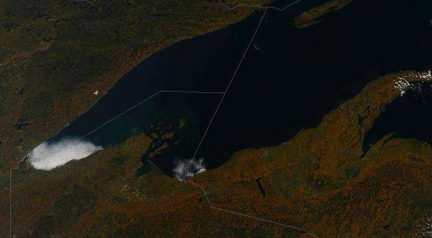
Fall Colors From Space
Thanks Scott Bachmeier (@CIMSS_Satellite) for this
satellite image of autumn tree color over MN, WI, and the UP of MI!
Gnarly! #WNTV ...
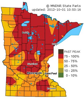
MN Fall Color Update
Thanks
to the MNDNR for the frequent updates on the fall colors statewide! As
of Sunday, most of central and northern MN were peaking! Get out there
and see them now (if you can)! A mid to late week storm will stir up the
winds and strip most of the leaves off the peaking trees by late week.
There will be a significant dent in the foliage on trees across the
state by PM Thursday/Friday as cold air settles in to the region!
Possible Mississippi Tornado
Thanks
to Derek Ladner (@vince_webb) for this picture out of Saucier, MS.
This is a POSSIBLE tornado on a tornado warned cell. Derek says there
was definite rotation with this particular part of the storm. It's hard
to actually see if there is a tornado in this picture since the tree
line is in the way, but it looks very ominous!

Tornado Reports
The
storm report map from Sunday shows 2 PRELIMINARY tornado reports in
southern Mississippi, one of those reports came from near Saucier, MS

Heavy Weekend Rainfall
Thanks to @emiliacakes for this picture out of Abilene, TX. Heavy rainfall over the weekend led to several areas of flooding.

7 Day Radar Estimates of Rainfall
The
7 day radar estimates of rainfall across the southern tier of the
nation suggests some 4" to 8" amounts from Texas to the Lower
Mississippi Valley.

Additional Rainfall
The
same storm system that slowly moved through Texas and the Lower Ohio
Valley over the weekend, will being lifting northeast through the
Tennessee and Ohio Valleys over the next couple of days. Additional
rainfall amounts in these areas could exceed 1" to 2" through midweek.

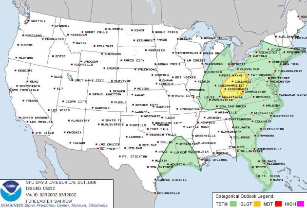
Tuesday Severe Weather Threat
The
Storm Prediction Center has issued a SLIGHT RISK of severe weather for
parts of the Ohio Valley. Hail, high winds and heavy rain would be the
primary threat, but an isolated tornado can't be ruled out!
Weekend Rain/Snow?
Other
than a little lingering shower/storm potential across Florida and the
New England states, there won't be much additional precipitation across
the country except for the Upper Mississippi Valley. A powerful late
week cold front will not only bring some much needed precipitation to
those areas, but temperatures will drop significantly and snow could fly
across the far north!

October Cold Blast
Look
at the images below. They represent the temperature analysis a few
thousand feet off the ground. The analysis for earlier Monday showed
'warmer' colors across much of the nation, especially from the Upper
Mississippi Valley to the West Coast.

In a
few short days... reality will set in when a significant cold front
drops into the Upper Mississippi Valley/Great Lakes Region. This air
mass will be cold enough to drop daytime high temperatures a good 30° to
40° from where they were last weekend and where they will be near
midweek this week.

November-like High Temps
Post
front, high temperatures will likely be more like that of a typical
early November day across the areas mentioned above. In fact, we will
struggle to get into the 50s for a number of locations! The image below
shows the high temperature forecast for this Saturday. With that said,
overnight lows will be cold enough to prompt widespread frost/freeze
conditions for a number of locations through the weekend/early next
week.

Thanks for checking in on this Monday, have a great rest of your week!
Don't forget to follow me on Twitter @TNelsonWNTV

No comments:
Post a Comment