76 F. high at Twin Cities International Airport Wednesday.
70 F. average high for September 19.
75 F. high on September 19, 2011.
Trace of rain fell at KMSP yesterday.
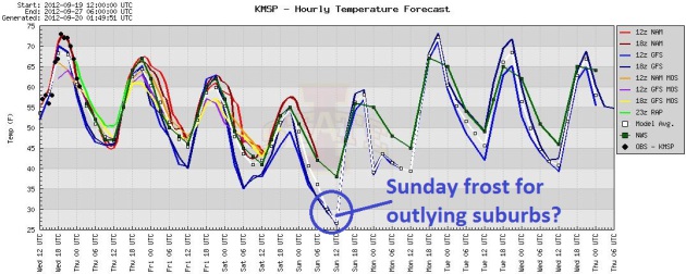
Frost possible over the outlying suburbs of the Twin Cities Sunday morning
70+ highs likely Monday thru Friday of next week. Don't abandon the summer clothes just yet.
Hail In Duluth. The same storms that went severe
near Hayward, Wisconsin (1" hail) sparked pea-size hail in the Duluth
area yesterday afternoon.
Twitter pic courtesy of Christy N. Ross.
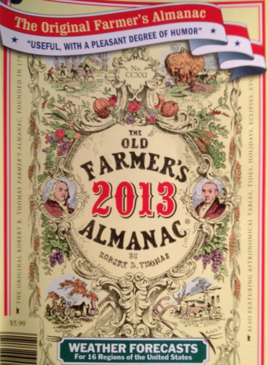
The Official Winter Forecast. Stop the presses (does
anyone say that anymore? Probably not. Sorry). I picked up a copy of
the 2012-2013 Farmer's Almanac yesterday, the bootleg copy I keep in my
(locked) desk drawer. A winter forecast that may surprise you below.
"...
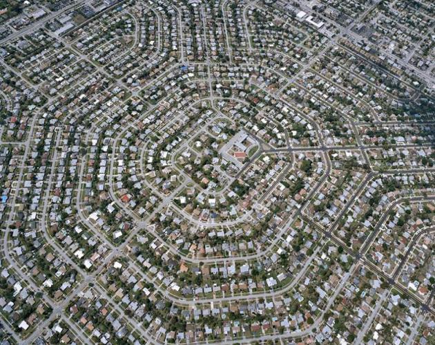
Today urban areas — ranging from Times Square to a small
town in India — cover perhaps 3 to 5% of global land. But Seto and her
co-authors calculate that between now and 2030, urban areas will expand
by more than 463,000 sq. mi. (1.2 million sq. km). That’s equal to
20,000 U.S. football fields being paved over every day for the first
few decades of this century." - from a Time Magazine story about urban sprawl and the potential impact on the environment. Photo:
twistedsifter.com.
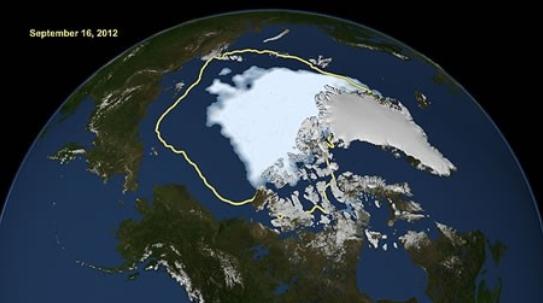
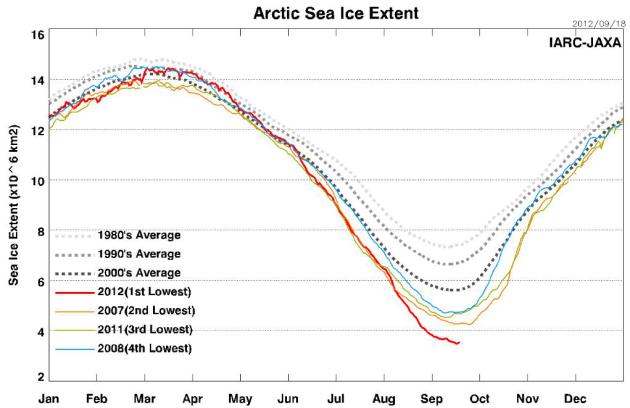
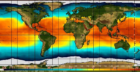
"
Arctic sea ice extent shatters 2007 record for lowest minimum by
an area the size of Texas. Last 6 years have had lowest 6 extents on
record (since 1979, when satellite measurements began)." - details from
The Capital Weather Gang.
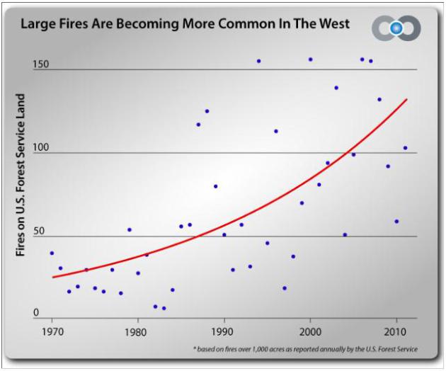
"
The National Research Council reports that for every degree
Celsius (1.8F) of temperature increase, the size of the area burned in
the Western U.S. could quadruple. According to the IPCC 4th Assessment
Report, summer temperatures in western North America could increase
between 3.6F and 9F by the middle of this century." - excerpt from a Climate Central story; full details below.
"...
At one point this summer, 97 percent of the surface of Greenland’s massive ice sheet was melting.
At current rates, Arctic waters could be ice-free in summer by the end
of the decade, scientists say. “Things are happening much faster than
what any scientific model predicted,” said Dr. Morten Rasch, who runs
the Greenland Ecosystem Monitoring program at Aarhus University in
Denmark." - excerpt from a New York Times article; details and links below.
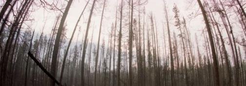
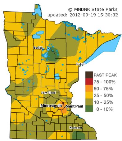
Fall Color Update. I was surprised to see that
50-75% of trees in the downtown metro area have ripened up. It's too
much of a coincidence that we have this one pocket of (advanced) color
close to the downtowns - urban heat island? More irrigation/water? Why
would colors be peaking in downtown Minneapolis before Brainerd or even
Duluth? I need to check on this - in the meantime
click here for the latest fall color update from the Minnesota DNR.
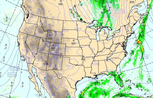
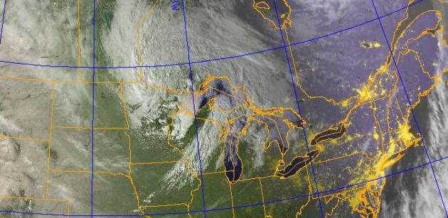
Today's Weather Map. The WRF model (valid 4 pm
today) shows heavy showers and T-storms lingering over Florida, the
latest Alberta Clipper whipping up showers over the northern Great
Lakes. Otherwise a dry, quiet day is shaping up for most of the USA.
Small Chance Of Frost Early Sunday. I think the
downtowns and close-in suburbs will not see a frost this weekend, but
far outlying suburbs could wake up to temperatures closer to 32 F. NOAA
is predicting 39F; I suspect mid-30s are possible outside the 494/694
freeway. And then we warm up nicely next week.
Raw Saturday - Mellow Sunshine Returns Next Week.
Have a Plan B for part of the day Saturday, temperatures will peak in
the 40s to low 50s with a northwest wind gusting over 20 mph at times, a
few passing showers (best chance morning hours). Sunday looks sunnier
and a bit warmer, but 70s return next week. Beautiful? Absolutely, but I
would remiss if I didn't mention the obvious: we need rain. ECMWF data
above.
Hints Of Slush. The GFS model is still printing out a
few snowflakes from the Minnesota Arrowhead into Wisconsin late Friday
night and Saturday morning. Do I think we'll see a few flakes in the
metro? No, but the atmosphere aloft will be marginally chilly enough for
a few flakes, best chance east of the St. Croix. A sign of the
seasons...
Race Is On As Ice Melt Reveals Arctic Treasures.
Ironically, warming and melting accelerated by the burning of fossil
fuels is melting polar ice, making it easier to drill for additional oil
and gas, which may further accelerate warming and melting (and
exploration). Here's an excerpt from
The New York Times: "
NUUK,
Greenland — With Arctic ice melting at record pace, the world’s
superpowers are increasingly jockeying for political influence and
economic position in outposts like this one, previously regarded as
barren wastelands. At stake are the Arctic’s abundant supplies of
oil, gas and minerals that are, thanks to climate change, becoming newly accessible along with increasingly navigable polar shipping shortcuts. This year, China has become a far more aggressive player in this frigid field, experts say, provoking alarm among Western powers."
Latest
Arctic Sea-Ice Monitor courtesy of JAXA, Japan Aerospace Exploration Agency, Earth Observation Research Center.
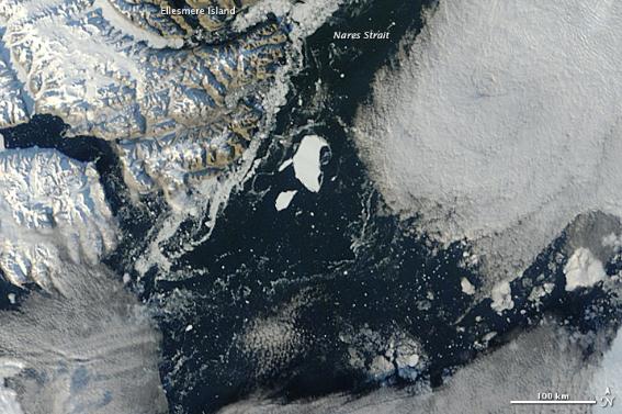
Massive Greenland Iceberg Now Adrift. Details from
EarthSky; here's an excerpt: "
NASA
has released a new image from space of a massive iceberg – widely
heralded in July 2012 to be twice the size of Manhattan – calved from
Greenland’s Petermann Glacier in mid-July 2012. NASA’s Terra satellite
saw it in September 2012, drifting slowly away from the glacier. It’s
drifting in the Nares Strait between Canada’s Ellesmere Island and
Greenland."
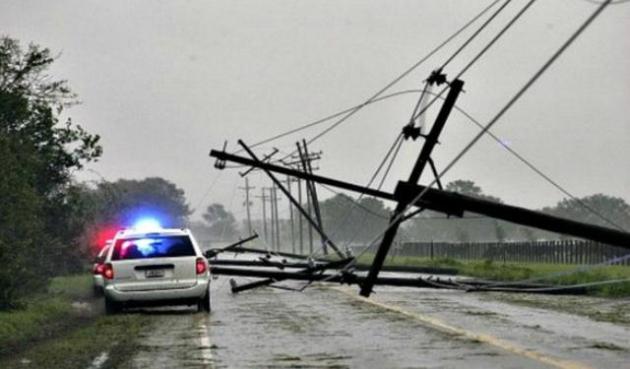
Entergy Reports Hurricane Isaac Power Restoration Costs Up To $500 Million. Details from Johnny Kelly at
examiner.com: "
The extensive damage caused to utilities following Hurricane Isaac, which left hundreds of thousands without power, will cost up to $500 million, the New Orleans-based Entergy Corporation said Tuesday. Hurricane Isaac made two landfalls on the southeastern Louisiana coast, both south of the city of New Orleans as the storm moved very slowly to the west and northwest. The first was just southwest of the mouth of the Mississippi
River in Plaquemines Parish and occurred the evening of Aug. 28, and
the second was just west of Port Fourchon and occurred in the early
hours of Aug. 29 with maximum sustained winds of 80 mph."
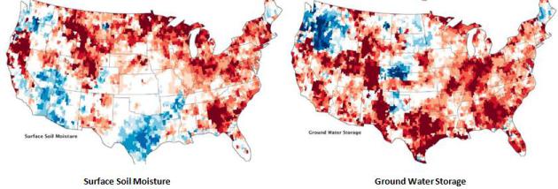
Signs Of U.S. Drought Are Underground. A new
generation of low-orbiting NASA "Grace" satellites are very powerful,
able to detect not only surface soil moisture, but what's happening deep
underground. Check out the "Ground Water Storage" map in the upper
right, and how it varies from what's happening at ground-level (upper
left). Details from
NASA's Earth Observatory: "
A
deep and persistent drought struck vast portions of the continental
United States in 2012. Though there has been some relief in the late
summer, a pair of satellites operated by NASA shows that the drought
lingers in the underground water supplies that are often tapped for drinking water and farming. The maps above combine data from the twin satellites of the Gravity Recovery and Climate Experiment
(GRACE) with ground-based measurements to map the relative amount of
water stored near the surface and underground as of September 17, 2012.
The top map shows moisture content in the top 2 centimeters (0.8
inches) of surface soil; the middle map depicts moisture in the “root
zone,” or the top meter (39 inches) of soil; and the third map shows
groundwater in aquifers. The wetness, or water content, of each layer
is compared to the average for mid-September between 1948 and 2009. The
darkest red regions represent dry conditions that should occur only 2
percent of the time (about once every 50 years). For a long-term view, download the animation below the third image, which shows the storage of groundwater from August 2002 through August 2012. (The animation is also available on YouTube.)"
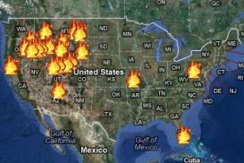
Report: The Age Of Western Wildfires. A combination
of factors: little snowcover last winter, drought, extreme heat, strong
winds, have all contributed to another major wildfire season out west.
It's a trend, according to this article at
Climate Central; here's an excerpt: "
The
2012 wildfire season isn’t over yet, but already this year is shaping
up to be the one of the worst on record in the American West. According
to the National Interagency Fire Center, with nearly two months still
to go in the fire season, the total area already burned this year is 30
percent more than in an average year, and fires have consumed more
than 8.6 million acres, an area larger than the state of Maryland."
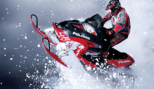
"Ask Paul". Weather-related Q&A:
Good afternoon,
"John Prusak here from Snow Goer magazine, a
North American snowmobiling magazine based right here in the good old
Twin Cities. I am putting together a story for an upcoming issue about
“types” of snow and getting at the question of who has the best snow and
most consistent snow in North America. Yeah, Utah has had the “Best
Snow On Earth” tagline on its license plates for years, but how much of
that is marketing fluff instead of powdery, fluffy snow?! My main focus
is on western states/provinces in the mountains, but I’d like to tie it
to lake effect snows here and in the Northeast as well.
In speaking with another meteorologist, he
shared a few generalities about the amount of moisture in snow and how
temperature has such a great influence on whether an area gets
bottomless powder or the “Sierra Cement” found around Lake Tahoe… are
there other factors I should work into my story? Would you have time for
a quick phone interview to discuss this?
Any help would be much appreciated."
John Prusak
Executive Editor and Group Publisher
Snow Goer Magazine and GS Media & Events
Plymouth
John - thanks for an excellent question. Is this marketing spin or is
there some truth to Utah's claims? I'm over my skis (or tracks) on this
one, so I teed up your question with a few people I trust, dedicated
snowmobilers who are serious about hitting the trails. Full disclosure:
Polaris is a valued customer, so we have a bit of an inside track there
as well. Here is the response I got back to your query:
"Good snow starts with a wet, heavy snowfall,
followed quickly by a deep freeze to start a base for thhe trails,
covering rough terrain. A frozen base gives a snowmobile the proper
consistency for carbides to steer responsively. Thereafter, the best
snow is light and fluffy. Snowmobiles require light and fluffy snow to
run properly. Radiator coils on a snowmobile depend on a mist of cold
snow to cool the two-stroke motors." - Cory Allar, St. Michael
"The best snow depends greatly on the type of
riding you plan on doing. Trail riding requires an adequate snowpack so
you don't end up in the dirt, but the conditions are perfect when you
get a fresh 3-4 inches of snow and temperatures of 10-25 degrees F.
Riding powder, regardless of mountain location or in-field, requires
consistently low humidity to both maintain the snow condition, but also
to eliminate crusting of the snow surface" - Todd Frostad, Media Logic Group (by friend and business partner).
So there you have it: the PR folks in Utah probably
have a legitimate claim, since humidity levels are consistently lower
in the western mountains for much of the winter. But I would argue that
from December thru February, with a consistent wind flow out of central
Canada, Minnesota's humidity levels are just as low as Utah's, and our
snow (nearly) as perfect. Sorry, couldn't resist waving the flag a
little. Good luck, and happy riding. If it was up to me we'd have 80" of
snow and temperatures in the 20s all winter. Sadly, it's not up to me.
Free Snowmobiling App. Yeah, I'm a little biased, since my company created this (
free) app, "
Snow Trails",
geared to snowmobilers. But in the spirit of planning ahead, download
this for Apple or Android. It shows where the snow is on the ground
(now) and how much is predicted. It also has every trail (and nearby
restaurants, dealers, bars, etc), so it's a great resource for getting
the most out of your sled. Give it 4-6 weeks and you'll be able to use
it.
_________________________________________________________________________
Hey Paul,
"
I enjoy reading your On Weather blog, but had a question. You
mention frequently the Arctic ice shelf and its record reduction in
size. What thoughts or explanation do you have for the record ice GROWTH
in the Antarctic region? I'm not refuting the numbers in the northern
hemisphere, but just wanted to know what you thought about what's going
on down south...WAY down south." :)
Thanks!
Daniel Lammert
Information Technologies Engineer
Physical Electronics, USA
Chanhassen
Daniel - thanks for the note. You're right - there's nothing to
refute when it comes to trends at the top of the world. The data is the
data. As for Antarctic trends I teed up your question with a couple of
climate scientists I know (and trust). Here is what Rob Honeycutt wrote
back:
"Both Arctic and Antarctic sea ice extent are characterized by fairly
large variations from year to year. The monthly average extent can vary
by as much as 1 million square kilometers (386,102 square miles) from
the year-to-year monthly average. The area covered by Antarctic sea ice
has shown a small (not statistically significant) increasing trend."
Gareth Renowden e-mailed me this response:
"1: The Arctic and Antarctic are literally polar
opposites - one's an ocean surrounded by land, the other's a cold
continent surrounded by ocean, and they're not expected to behave the
same way as warming progresses.
2: Despite that, the Antarctic peninsula's one
of the fastest warming places on the planet, ice shelves have been
crumbling, and satellites suggest the continental ice sheet is losing
mass - particularly in West Antarctica."
Christian Shorey writes:
"From a centurey scale view, there are
indications that Antarctic sea ice has declined 20-25% mainly from the
40s to the 70's. See:
http://data.aad.gov.au/analysis/crc/eceawiki/files/delamare1997.pdf
* A good explanation of the difference between Arctic and Antarctic ice trends can be found here, courtesy of the
National Snow and Ice Data Center.
Skeptical Science
has another helpful page that highlights the polar opposites (sorry)
between the North Pole and the South Pole; here's an excerpt: "Skeptic
arguments that Antarctica is gaining ice frequently hinge on an error of
omission, namely ignoring the
difference between land ice and sea ice. In glaciology and particularly with respect to Antarctic ice,
not all things are created equal. Let us consider the following differences.
Antarctic land ice
is the ice which has accumulated over thousands of years on the
Antarctica landmass itself through snowfall. This land ice therefore is
actually stored ocean water that once fell as precipitation.
Sea ice in Antarctica is quite different
as it is generally considered to be ice which forms in salt water
primarily during the winter months. In Antarctica, sea ice grows quite
extensively during winter but nearly completely melts away during the
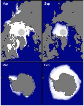
summer (Figure 1). That is where the important difference between
antarctic and arctic sea ice exists.
Graphic credit above: Coverage of sea ice in both the Arctic
(Top) and Antarctica (Bottom) for both summer minimums and winter
maximums Source:
National Snow and Ice Data Center
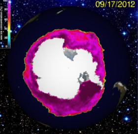
University of St. Thomas climate scientist
John Abraham wrote:
"Here is the key site (
The Cryosphere Today).
The
southern hemisphere varies wildly. Sometimes it is positive, sometimes
negative. There is a very slight positive trend in Antarctic ice area
because of the ice shelf growth relate to ozone holes and the
circumpolar current. There is a net ice LOSS in the south (land ice
loss exceeds the very small ice shelf gains). When you add it together, a
small area increase in the south, huge area decrease in north = net
area decrease worldwide."
* image above courtesy of The Cryosphere Today, courtesy of the Polar Research Group at the U. of Illinois.
Hello Paul Douglas
"Would love your expertise on this question! We follow your weather expertise in the StarTrib daily.
What do you think the weather will be
Saturday October 6?? Our son and our "nearly" daughter -in-law will be
married outdoors at 2PM in the Brooklyn Center area. There is an outdoor courtyard and fountain and we hope it will be beautiful with color!
FYI.... October 15 1977 was 63 degrees and beautifully sunny for us with a hard frost that night."
Thank you,
Kris and Bob Rhodes
Kris and Bob - first of all congratulations on
the impending nuptials! Very happy for you and your family. In all
honesty October 6 is still a long way off. The models and forecasts will
change between now and then. Count on it.
Long-Range Outlook. The GFS (which goes out thru
October 5) shows a mild spell for the first week of October, highs in
the 60s and 70s. Buyer beware: although I can't guarantee anything at
this point, based on the latest, greatest available guidance it looks
like you may just salvage a lukewarm day. We're in a drought - the odds
of the pattern reversing between now and October 6 are slim to nil.
Check the
GFS Outlook yourself for the Twin Cities. I'll kick the Doppler and hope for the best!
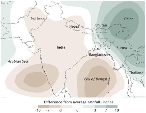
Late Monsoon Leads To Drought In India. ClimateWatch at
climate.gov has more details: "
The
rainy season in India arrived late and delivered far less
precipitation than usual in summer 2012, leading to severe drought
across large parts of the country. More than 50 percent of the labor
force in India—the world’s second most populous country—makes a living
in agriculture. Compare that to the United States, where the figure is
less than 1 percent, and you can start to imagine the widespread
hardship that a drought can cause."
Graphic credit above: "
Difference from average rainfall
from June–July 2012 compared to the recent historical average
(1981-2010). Greens indicate 3-10 inches more rain than average; brown
indicate 3-10 inches less rain than average." (Map by Dan Pisut, NOAA Environmental Visualization Laboratory, based on
NCEP reanalysis data from NOAA’s Earth System Research Laboratory.)
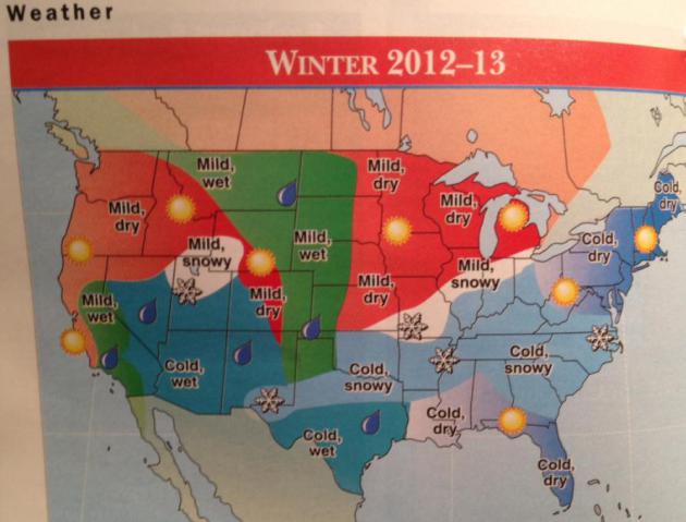
Farmer's Almanac: No Major Winter Weather Worries.
Here is a summary of November - March weather for the nation, found on
page 80 of the 2012-2013 Farmer's Almanac. Cold and dry for New England,
cold and snowy (for Atlanta, Memphis and Dallas!) and "mild and dry"
for Minnesota, Wisconsin and most of the Upper Midwest, a little
wetter/snowier as you head toward the western Dakotas and northern
Rockies. This is based on a fading La Nina, solar activity, and secret
ingredients that shall not be revealed! Hey, they have as good a shot at
the winter outlook as anyone else. Another data point. My gut: last
winter was Minnesota's 3rd warmest on record. I doubt this winter will
be warmer than last, in fact I'd bet a bagel that it'll be colder than
last winter, but still warmer than average overall.
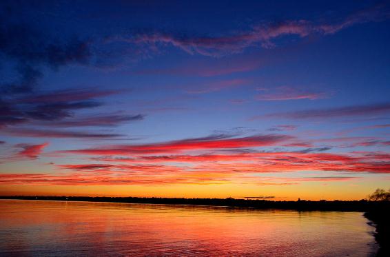
Long Island Sunset. This was the scene over Great South Bay, Long Island on Wednesday - truly postcard-worthy. Thanks to
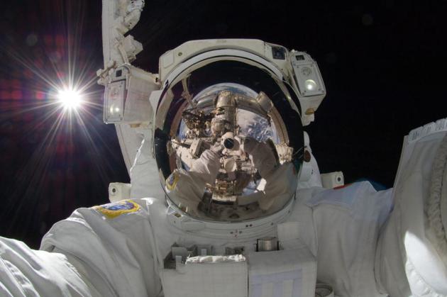
Photo Of The Day: Out Of This World. Here's a terrific photo from NASA and their
Astronomy Picture of the Day: "
Is it art? Earlier this month, space station astronaut Aki Hoshide (Japan) recorded this striking image while helping to augment the capabilities of the Earth-orbiting International Space Station
(ISS). Visible in this outworldly assemblage is the Sun, the Earth,
two portions of a robotic arm, an astronaut's spacesuit, the deep
darkness of space, and the unusual camera taking the picture. This image joins other historic -- and possibly artistic -- self-portraitstakenpreviously in space. The Expedition 32 mission ended yesterday when an attached capsule undocked with the ISS and returned some of the crew to Earth."
Apple's Magic Is In The Turn, Not The Prestige. An interesting (marketing and innovation) take on the latest iPhone 5 from
TechCrunch: "...
Apple
is not and will not change things just for the sake of change. And
while some may now be clamoring for this change, the paradox is that if
Apple did make some big changes, many of the same people would bitch
and moan about them. Apple is smart enough to know that in this case,
most people don’t really want change, they just think that they do
because that’s the easiest way to perceive value: visual newness.
Apple’s focus remains on The Turn, the process by which they make the
ordinary extraordinary. But even with a masterful Prestige, it’s hard
to convey that commitment. That is, until you walk into an Apple Store
and pick up the product."
A Road Crew Painted A Stripe Over This Dead Racoon.
Good grief, can't we have a little more respect for roadkill? This would
never, ever happen in Minnesota, right? Right? The story from
Jalopnik; here's an excerpt: "
Why
is roadkill is so funny? Whatever that sticky patch of mangled fur
used to be probably suffered and unfortunate demise, yet it can still cause a chuckle,
especially when it has a road stripe painted over top of it. A
Pennsylvania line painting crew failed to notice — or care about — this
raccoon as they engaged in what has to be one of the most dull jobs in
the world. A motorcyclist told the Tribune Democrat that he laughed so hard he almost crashed his bike."
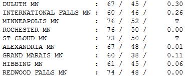
Not Bad. It was milder than expected or predicted - a
trend that has continued much of 2012. The actual observed temperature
winds up 2-4 F. warmer than the models forecast. Today's clipper yanked
enough warm air north for a high of 73 St. Cloud, 76 at Rochester and
the Twin Cities. Gusty northwest winds kicked in on the backside of the
clipper by late afternoon - hail-producing T-storms from Duluth into
northern Wisconsin.
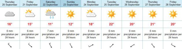
Paul's Conservation Minnesota Outlook for the Twin Cities and all of Minnesota:
TODAY: Partly sunny and pleasant much of the day. Winds: 10-20. High: 66
THURSDAY NIGHT: Clouds, a few showers possible. Low: 48
FRIDAY: Showers taper. Cool wind. High: 58
SATURDAY: Ragged, cold and showery. Low: 42. High: 49
SUNDAY: Frost outlying suburbs? Sun returns, a bit milder. Low: 35. High: 59
MONDAY: Sunny and milder. Perfect. Low: 45. High: near 70
TUESDAY: Warm sun. Take the day off. Low: 52. High: 72
WEDNESDAY: Shorts & A/C return. Hints of August. Low: 54. High: 74
El Nino = Warmer Winter? Maybe Not
I stand by my official winter outlook. "Colder
with some snow." Back to you, Earl.
Oh, you want dates and
details? Here, let me shake my Ouija Board for you!
Historic melting in the Arctic is a wild card
(warmer, high pressure over the North Pole may push the bitter, "polar
vortex" farther south). That would make for a long, cold winter for
Minnesota.
An El Nino is brewing, but that does NOT mean another mild winter is a foregone conclusion.
Katsumi Matsumoto is an oceanographer and
climate model specialist at the U. of Minnesota. Monday he shared new
research, showing ENSO events (El Nino & La Nina) have been focused
more in the central Pacific vs. the eastern Pacific in recent years.
This shift has influenced winter temperatures over the northwest and
southeast USA. "There is little impact of the latter ENSO on the
Midwest" he e-mailed. Moral of the story: don't count on El Nino to
insulate us from cold & snow. We could still get whacked.
A quiet Thursday gives way to blustery clippers;
showery rains tonight into much of Saturday. Frost can't be ruled out
for outlying suburbs Sunday morning.
Good news: a string of 70s return next week, maybe 80 by midweek?
Whew..
* graphic above courtesy of NOAA's
El Nino page.
Climate Stories...
"Zeal without knowledge is fire without light." – Thomas Fuller
Should The GOP Champion Climate Change As A National Security Issue? Here's an excerpt from a thought-provoking story at
globalwarming.org: "
Yes, argues Daveed Gartenstein-Ross in The Atlantic (Sep. 17, 2012). Gartenstein-Ross is the author of Bin Laden’s Legacy: Why We’re Still Losing the War on Terror. I haven’t read the book, but judging from the favorable reviews, Gartenstein-Ross
has the ear of defense hawks of both parties. Does he offer sound
advice on global warming? In his Atlantic article,
Gartenstein-Ross chides Republicans for taking a “decidely unrealistic
tack” on climate change. “The available evidence overwhelmingly
suggests that climate change is real; that extreme weather events are
increasing; and that this dynamic will have an impact on American
national security, if it hasn’t already,” he avers."
PBS NewsHour's Climate Change Report Raises Eyebrows. Details (and the original PBS NewsHour video that raised a furor among climate scientists) from
Huffington Post; here's an excerpt: "
A
recent report from "PBS NewsHour" on climate change has drawn sharp
criticism from climate groups that feel it provides a false sense of
debate around the facts of climate change. The segment, which aired on
September 16, features interviews with "converted skeptic"
and University of California, Berkeley professor Richard Muller, along
with climate skeptic Anthony Watts, a retired meteorologist. Despite
PBS' acknowledgement that climate scientists almost unanimously concur
that manmade climate change is occurring, critics charge that featuring
Watts "propagates confusion"
and obscures the distinction between a scientific consensus and a very
small, but vocal, minority who has a vested interest in this confusion."
* photo courtesy of
Media Matters, which has another angle on the (odd) PBS NewsHour story that has triggered an outcry in the scientific community.
Urban Planet: How Growing Cities Will Wreck The Environment Unless We Build Them Right. Time Magazine has an interesting story; here's an excerpt: "
It’s
easy to miss amid the day to day headlines of global economic
implosion, Presidential campaign foibles and Mideast rage, but there is a
less conspicuous kind of social upheaval underway that is fast
altering both the face of the planet and the way that human beings
live. That change is the rapid acceleration of urbanization,
as more and more people in every corner of the world put down their
farm tools and move from the countryside or the village to the city. In
2008, for the first time in human history, more than half the world’s population was living in towns and cities. And as a new paper
published in the Proceedings of the National Academy of Sciences shows,
the process of urbanization will only increase in the decades to come —
with an enormous impact on biodiversity and potentially on climate
change."
Climate Change: Optimizing Regulatory And Market Forces. The story from
EnergyBiz; here's an excerpt: "
Caught
in the shelling between those who think that addressing climate change
is urgent and those who think such action is farcical, voters are
thoroughly confused. The issue has become increasingly partisan with
fossil fuel interests funding one side and green technology providers
bankrolling the other. Beyond the money and the loud voices that seek
to distort the debate, some important environmental and economical
factors are surfacing. Consider the severe summer heat waves and the
subsequent droughts, all of which has hurt food production this year.
Then add to that the number of typhoons rolling across Asia, and it is
fueling concerns that man-made global warming is dawning right now."


 Should The GOP Champion Climate Change As A National Security Issue? Here's an excerpt from a thought-provoking story at globalwarming.org: "Yes, argues Daveed Gartenstein-Ross in The Atlantic (Sep. 17, 2012). Gartenstein-Ross is the author of Bin Laden’s Legacy: Why We’re Still Losing the War on Terror. I haven’t read the book, but judging from the favorable reviews, Gartenstein-Ross
has the ear of defense hawks of both parties. Does he offer sound
advice on global warming? In his Atlantic article,
Gartenstein-Ross chides Republicans for taking a “decidely unrealistic
tack” on climate change. “The available evidence overwhelmingly
suggests that climate change is real; that extreme weather events are
increasing; and that this dynamic will have an impact on American
national security, if it hasn’t already,” he avers."
Should The GOP Champion Climate Change As A National Security Issue? Here's an excerpt from a thought-provoking story at globalwarming.org: "Yes, argues Daveed Gartenstein-Ross in The Atlantic (Sep. 17, 2012). Gartenstein-Ross is the author of Bin Laden’s Legacy: Why We’re Still Losing the War on Terror. I haven’t read the book, but judging from the favorable reviews, Gartenstein-Ross
has the ear of defense hawks of both parties. Does he offer sound
advice on global warming? In his Atlantic article,
Gartenstein-Ross chides Republicans for taking a “decidely unrealistic
tack” on climate change. “The available evidence overwhelmingly
suggests that climate change is real; that extreme weather events are
increasing; and that this dynamic will have an impact on American
national security, if it hasn’t already,” he avers."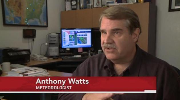 PBS NewsHour's Climate Change Report Raises Eyebrows. Details (and the original PBS NewsHour video that raised a furor among climate scientists) from Huffington Post; here's an excerpt: "A
recent report from "PBS NewsHour" on climate change has drawn sharp
criticism from climate groups that feel it provides a false sense of
debate around the facts of climate change. The segment, which aired on
September 16, features interviews with "converted skeptic"
and University of California, Berkeley professor Richard Muller, along
with climate skeptic Anthony Watts, a retired meteorologist. Despite
PBS' acknowledgement that climate scientists almost unanimously concur
that manmade climate change is occurring, critics charge that featuring
Watts "propagates confusion"
and obscures the distinction between a scientific consensus and a very
small, but vocal, minority who has a vested interest in this confusion."
PBS NewsHour's Climate Change Report Raises Eyebrows. Details (and the original PBS NewsHour video that raised a furor among climate scientists) from Huffington Post; here's an excerpt: "A
recent report from "PBS NewsHour" on climate change has drawn sharp
criticism from climate groups that feel it provides a false sense of
debate around the facts of climate change. The segment, which aired on
September 16, features interviews with "converted skeptic"
and University of California, Berkeley professor Richard Muller, along
with climate skeptic Anthony Watts, a retired meteorologist. Despite
PBS' acknowledgement that climate scientists almost unanimously concur
that manmade climate change is occurring, critics charge that featuring
Watts "propagates confusion"
and obscures the distinction between a scientific consensus and a very
small, but vocal, minority who has a vested interest in this confusion." Urban Planet: How Growing Cities Will Wreck The Environment Unless We Build Them Right. Time Magazine has an interesting story; here's an excerpt: "It’s
easy to miss amid the day to day headlines of global economic
implosion, Presidential campaign foibles and Mideast rage, but there is a
less conspicuous kind of social upheaval underway that is fast
altering both the face of the planet and the way that human beings
live. That change is the rapid acceleration of urbanization,
as more and more people in every corner of the world put down their
farm tools and move from the countryside or the village to the city. In
2008, for the first time in human history, more than half the world’s population was living in towns and cities. And as a new paper
published in the Proceedings of the National Academy of Sciences shows,
the process of urbanization will only increase in the decades to come —
with an enormous impact on biodiversity and potentially on climate
change."
Urban Planet: How Growing Cities Will Wreck The Environment Unless We Build Them Right. Time Magazine has an interesting story; here's an excerpt: "It’s
easy to miss amid the day to day headlines of global economic
implosion, Presidential campaign foibles and Mideast rage, but there is a
less conspicuous kind of social upheaval underway that is fast
altering both the face of the planet and the way that human beings
live. That change is the rapid acceleration of urbanization,
as more and more people in every corner of the world put down their
farm tools and move from the countryside or the village to the city. In
2008, for the first time in human history, more than half the world’s population was living in towns and cities. And as a new paper
published in the Proceedings of the National Academy of Sciences shows,
the process of urbanization will only increase in the decades to come —
with an enormous impact on biodiversity and potentially on climate
change."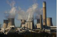 Climate Change: Optimizing Regulatory And Market Forces. The story from EnergyBiz; here's an excerpt: "Caught
in the shelling between those who think that addressing climate change
is urgent and those who think such action is farcical, voters are
thoroughly confused. The issue has become increasingly partisan with
fossil fuel interests funding one side and green technology providers
bankrolling the other. Beyond the money and the loud voices that seek
to distort the debate, some important environmental and economical
factors are surfacing. Consider the severe summer heat waves and the
subsequent droughts, all of which has hurt food production this year.
Then add to that the number of typhoons rolling across Asia, and it is
fueling concerns that man-made global warming is dawning right now."
Climate Change: Optimizing Regulatory And Market Forces. The story from EnergyBiz; here's an excerpt: "Caught
in the shelling between those who think that addressing climate change
is urgent and those who think such action is farcical, voters are
thoroughly confused. The issue has become increasingly partisan with
fossil fuel interests funding one side and green technology providers
bankrolling the other. Beyond the money and the loud voices that seek
to distort the debate, some important environmental and economical
factors are surfacing. Consider the severe summer heat waves and the
subsequent droughts, all of which has hurt food production this year.
Then add to that the number of typhoons rolling across Asia, and it is
fueling concerns that man-made global warming is dawning right now."
No comments:
Post a Comment