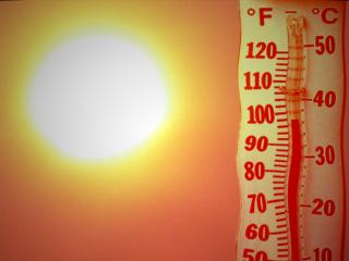
61 F. high on Tuesday in the Twin Cities.
71 F. average high for September 18.
61 F. high on September 18, 2011.
Frost possible for the outlying suburbs of the Twin Cities Sunday morning.
Slush for northern Wisconsin Saturday? The GFS is hinting at a rain/snow mix. No cause for panic in the metro...yet.
5 of Minnesota's warmest 7 winters since 1895 have taken place since 1997-1998. More from Dr. Mark Seeley below.
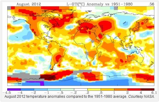
3rd hottest summer for the USA, 2.3 F. warmer than
the 20th century average. Only the summers of 2011 and 1936 were hotter
over the lower 48 states. A complete summer recap from NOAA NCDC below.
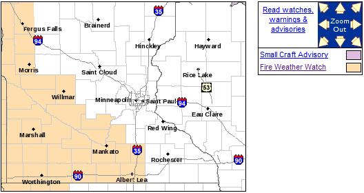
Fire Weather Watch. The combination of deepening
drought, low humidity and gusty winds accompanying the next clipper will
create ripe conditions for fire over southwestern and west central
Minnesota. Details from the Twin Cities NWS:
...FIRE WEATHER WATCH IN EFFECT WEDNESDAY AFTERNOON THROUGH
WEDNESDAY EVENING FOR WEST CENTRAL THROUGH SOUTH CENTRAL
MINNESOTA...

.A DRY COLD FRONT WILL MOVE ACROSS THE WATCH AREA WEDNESDAY
MORNING. NORTHWEST WINDS FROM 20 TO 25 MPH WILL OCCUR IN THE
AFTERNOON ALONG WITH GUSTS APPROACHING 35 MPH. RELATIVE HUMIDITY
VALUES WILL LOWER INTO THE 20 TO 25 PERCENT RANGE DURING THIS TIME
FRAME AS WELL. THE COMBINATION OF THE WIND AND LOW HUMIDITY MAY
RESULT IN DANGEROUS FIRE WEATHER CONDITIONS. THE FIRE WEATHER
WATCH IS ALONG AND SOUTH OF A LINE FROM MORRIS TO ST. PETER TO
ALBERT LEA.
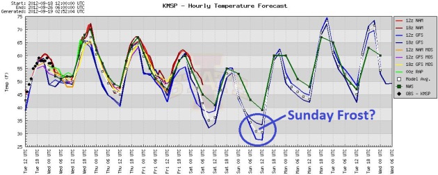
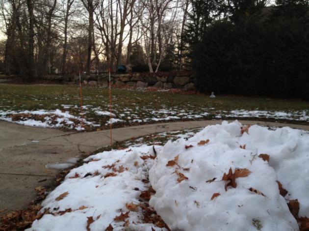
A 35 Degree Temperatures Swing. After peaking near
70 today (mild flow out ahead of a fast-moving clipper) temperatures
begin to tumble - Saturday looks like the chilliest day with highs in
the low to mid 50s. If skies clear and winds ease a light frost can't be
ruled out for the outlying suburbs Sunday morning - the best chance of
frost looking out 2 weeks. Graphic: Iowa State.
Bottom 10% Record heat and drought has resulted in a 2012 USA tornado count in the bottom 10%. Details from kansascity.com below.
"...
Now a Massachusetts Institute of Technology study has given
an estimate based on model simulations and observations: With every 1 C
rise in temperature, the study finds, tropical regions will see 10%
heavier rainfall extremes, with possible impacts for flooding in
populous regions." - from a story at rdmag.com below.
Minnesota's Warmest Winters. Dr. Mark Seeley e-mailed me some interesting information Monday. Using HDD (heating degree data) for the
entire state of Minnesota from November 1 thru March 31, he calculated the rankings dating back to 1895:
1). 2011-2012
2). 1999-2000
3). 2001-2002
6). 1997-1998 (strongest El Nino on record)
7). 2005-2006
According to Seeley, "..
.5 of the warmest 7 have occurred since 1997-1998 using statewide data."
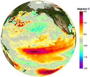
Two Types of ENSO. Here is a letter that came into
the Star Tribune Tuesday I wanted to share with readers. Katsumi
Matsumoto is an oceanographer who runs climate models. My take-away from
Katsumi's message (below): there is a recent trend for ENSO (both La
Nina cooling and El Nino warming phases) to have a lesser impact on
winter temperatures and weather for Minnesota and northern tier states -
more of an influence on the Pacific Northwest and the southeastern USA.
Against this backdrop we have a gradual warming trend (worldwide), but
the Arctic is a huge wildcard. Extreme melting this year (a new historic
low in Arctic ice) may displace the Polar Vortex southward, increasing
the possibly of bitter air penetrating into the USA. We're also seeing a
trend toward "polar amplification", more warming at northern latitudes
is decreasing the north-south temperature gradient over North America,
resulting in lower jet stream winds, which, in turn, increases the
potential for blocking patterns that can become temporarily "stuck" for
days at a time. I wish it were an easy formula. It's not.
Anyone who claims to have the inside track on what this winter will be like is trying to sell you something. Buyer beware.
Mr. Paul Douglas,
"I'm a professor of Earth Sciences at the U. As a subscriber to the Star Tribune, I enjoy your daily column. In today's column you mention that ENSO is typically associated with a mild winter in the Midwest. The notion is indeed supported by empirical evidence and something I mention in my own teaching as well.
However, you might be interested to know that we recognize two types of ENSO. Unlike
the conventional ENSO (Eastern equatorial Pacific), the Central-Pacific
ENSO, which is becoming more frequent in recent years, is associated
with temperature anomalies in the northwestern and southeastern US. There is little impact of the latter ENSO on the Midwest. I hope this bit of new finding will be useful to you.
I attach the relevant publication for your information."
Sincerely,
-Katsumi
Katsumi Matsumoto, Associate Professor
Dept. of Earth Sciences, University of Minnesota
* File El Nino image above courtesy of NOAA.
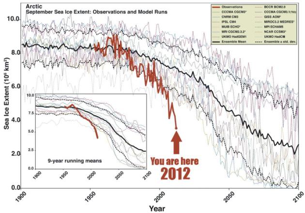
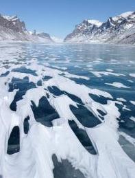
Worrying Trends At The Top Of The World. This
graph
pretty much sums up the state of the Arctic - magically transformed
into a giant Slushie this year, approximately 40-50% the size it was
back in the 1970s. What impact will this melting have on weather over
the Northern Hemisphere? Stay tuned - when I say we're in uncharted
waters it's not an exaggeration. More details on the graph above from
the AGU, the
American Geophysical Union: "
From
1953 to 2006, Arctic sea ice extent at the end of the melt season in
September has declined sharply. All models participating
in the Intergovernmental Panel on Climate Change Fourth
Assessment Report (IPCC AR4) show declining Arctic ice cover over
this period. However, depending on the time window
for analysis, none or very few individual model simulations show trends
comparable to observations. If the multi-model
ensemble mean time series provides a true representation of forced
change by greenhouse gas (GHG) loading, 33–38%
of the observed September trend from 1953–2006 is externally forced,
growing to 47–57% from 1979–2006. Given
evidence that as a group, the models underestimate the GHG response,
the externally forced component may be larger.
While both observed and modeled Antarctic winter trends are small,
comparisons for summer are confounded by
generally poor model performance."
* we are now
18% below the previous record low for Arctic ice set in 2007. Details from
Climate Denial Crock of the Week with Peter Sinclair.
Melting Arctic Ice Could Bring A Harsh New England Winter. Then again, it may not. There are too many variables in play. WBUR Radio has an
interesting interview that focuses on changes in the Arctic, and how melting there may displace cold air south into the USA; here's an excerpt: "
Some
weather researchers are predicting we could be in for a rough winter
this year due to melting ice thousands of miles away in the Arctic
Ocean. Research shows Arctic ice melted at a record pace this summer,
melting to the smallest area ever observed. Scientists say that could
mean more extreme weather this winter. Jennifer Francis, a research
professor at Rutgers University’s Institute of Marine and Coastal
Sciences, joins WBUR’s Morning Edition to help us understand why.
Francis has studied melting Arctic ice and its effects on weather."
File photo above: NOAA.
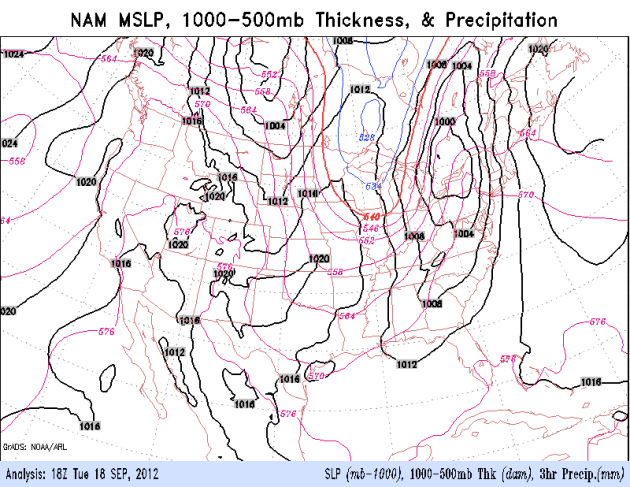
Family of Clippers. NOAA's 84-hour NAM model shows
the east coast drying out today, an Alberta Clipper spreading showers
across the Upper Midwest into the Great Lakes. A second surge of chilly,
Canadian air pushes south by Friday, setting the stage for a chilly
weekend from the Twin Cities to Milwaukee and Detroit. The west stay
sunny and hot; the southeast finally enjoys a few dry, sunny, quiet days
in a row.
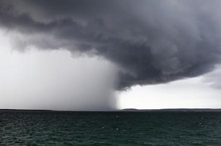
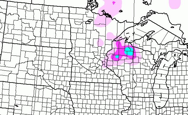
Saturday Slush? I have my doubts - but in the spirit
of full disclosure the GFS model is hinting at a little slushy snow
(probably melting on contact if it falls at all) over northern Wisconsin
Saturday. Yeah...it's too early to be showing this graphic. Odds are it
won't happen, but just in case...
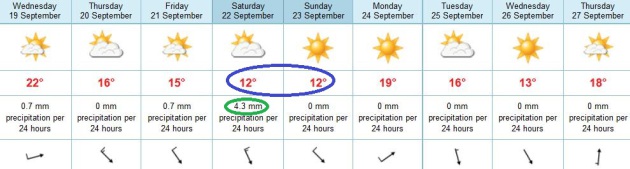
European Solution. The ECMWF, which consistently
does a better job (in my humble opinion) beyond 3-4 days, shows low 50s
Saturday and Sunday. The best chance of showers: Saturday. Sunday looks
marginally better: upper 50s to near 60 with less wind. More 60s return
next week, maybe a few days topping 70 F.
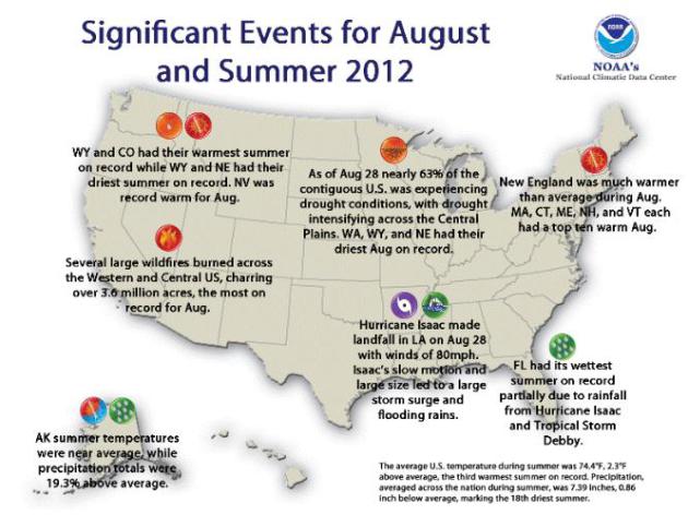
Summer Of 2012 Highlights. Here's an excerpt of a comprehensive summary of a very hot, dry summer for most of the USA, courtesy of
NCDC, NOAA's National Climatic Data Center:
- The summer season was warmer than average for a large portion of contiguous United States, with the exception of the Southeast and parts of the Northwest. Sixteen states across the West, Plains, and Upper Midwest had summer temperatures among their ten warmest. Colorado and Wyoming each had their record hottest summer, with seasonal temperatures 4.4°F and 4.9°F above average, respectively. Much of the Northeast was warmer than average, where seven states from New Hampshire to Maryland had a top ten warm summer.
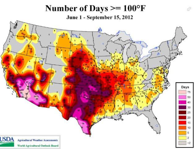
100 Degree Days This Year. We just got a taste in
Minnesota; portions of south Texas and Oklahoma saw more than 40 days
this summer above 100 F. Details from USDA and WeatherNation TV's
Facebook page: "
Our
friends with the USDA shared this graphic with us that shows the total
number of 100+ degree days through September 15, 2012. Fortunately,
temperatures are starting to moderate and Autumn is right around the
corner! The Autumnal Equinox (the official beginning of Autumn) is on
September 22."
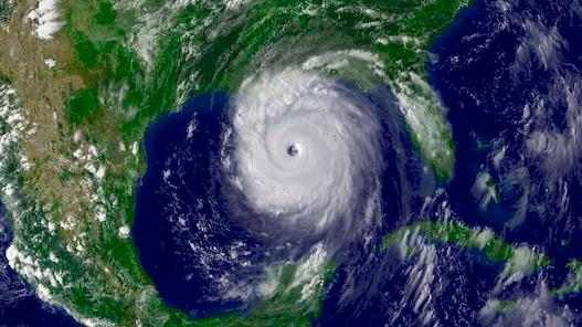
Fresh Water Feeds Hurricane's Fury. Here's a clip of a fascinating article from
Eureka Alert and the U.S. Department Research News: "
Hurricanes and tropical cyclones become up to 50 percent more intense when passing over oceans inundated with fresh water".
When
hurricanes blow over ocean regions swamped with fresh water, the storm
can unexpectedly intensify. According to a new study led by
researchers at Pacific Northwest National Laboratory and published in
the Proceedings of the National Academy of Sciences Early Edition,
though the probability that hurricanes will hit these conditions is
small—about 10 to 23 percent—the rate at which they intensify can be
relatively higher when they do, by as much as 50 percent on average.
"Sixty percent of the world's population lives in areas affected by
tropical cyclones," said Dr. Karthik Balaguru, lead author of the study
and oceanographer at PNNL. "Cyclone Nargis killed more than one hundred
and thirty eight thousand people in Burma in 2008. We can predict the
paths cyclones take, but we need to predict their intensity better to
protect people susceptible to their destructive power."
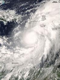
Photo credit above: "Hurricane Omar
wreaked destruction on the eastern Caribbean islands. As Omar approached
the islands it covered a huge expanse from the northern edge of South
America to well past Puerto Rico." Image captured by the Moderate
Resolution Imaging Spectroradiometer on NASA's Aqua satellite, October
15, 2008. Photo courtesy of NASA Earth Observatory.
NHC Fast-Tracks New Storm Surge Warnings. NHC is
experimenting with new ways to get the information out about hurricane
storm surges, the sudden rise in sea level triggered by low pressure and
sustained winds. Here's an excerpt from
gainesville.com: "
The
National Hurricane Center is planning to add a new "storm surge
warning" — as well as high-resolution maps detailing surge depths — to
the list of advisories it issues when tropical systems threaten the
United States. Hurricane center officials have been debating for four
years whether to completely overhaul the Saffir-Simpson Wind Scale,
which only reflects wind speed and not dangerous surges, rain flooding
and tornado threats."
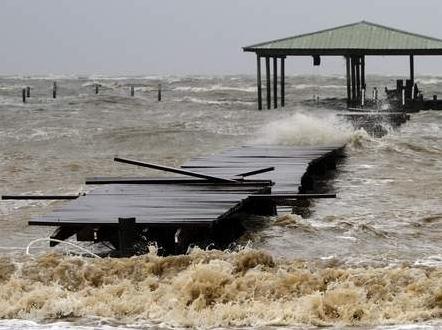
Photo credit above: "
This Aug. 28, 2012 file photo shows
waves caused by Hurricane Isaac tearing apart a pier along the Mobile
Bay in Coden, Ala., near Dauphin Island." (AP Photo/Butch Dill, file)
After A Busy 2011, Numbers of Tornadoes Dramatically Down This Year.
Just a gut call here, but I suspect the record heat and drought had
something to do with this (rare) silver lining. Here's an excerpt of an
article at
kansascity.com: "
When
most folks talk about the drought of 2012, they’re referring to the
lack of rain. But weather officials have noticed the absence of
something else: tornadoes. The past four months have all seen record or
near-record lows for tornado totals, said Greg Carbin, warning
coordination meteorologist for the National Oceanic and Atmospheric
Administration’s Storm Prediction Center. With the most active months
for tornadoes now past, 2012 is in the bottom 10 percent of years for
tornadoes since uniform records began being kept in 1952. “Pretty
remarkable,” Carbin said."
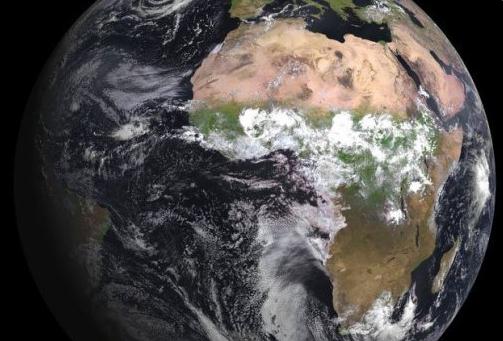
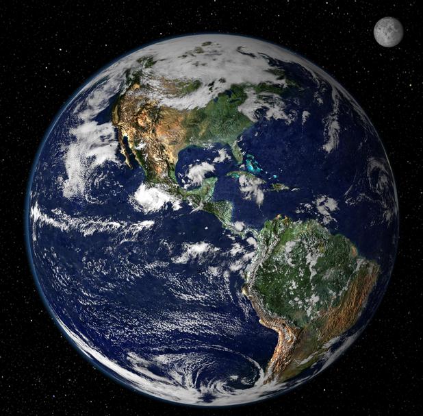
U.N. Hails 25-Year Ozone Treaty For Preventing Disaster. Details from
phys.org; here's the introduction: "
This
image, released by Eumetsat in August 2012, shows the planet Earth
taken by the Spinning Enhanced Visible and Infrared Imager instrument on
the MSG-3 satellite. The United Nations treaty to protect the ozone
layer signed nearly 25 years ago prevented an environmental disaster, a
chief U.N. scientist said Friday, cautioning though that the Earth's
radiation shield is still under threat."
Read more here: http://www.kansascity.com/2012/09/17/3819348/after-a-busy-2011-numbers-of-tornadoes.html#storylink=cpy
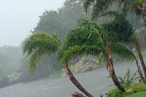
Blue Skies, Distractions Arise: How Weather Affects Productivity.
Wait, we get easily bored and distracted on the sunny, gorgeous days?
Now there's scientific PROOF that this is the case. Here's an excerpt
from a
Harvard Business School story: "
Autumn
has sprung, and the cold, dreary days of winter are around the corner.
But take heart, wistful sun lovers. It turns out that lousy weather
is actually good for business operations. A new research paper reports
that a decrease in sunny weather is directly related to an increase in
worker efficiency. In "Rainmakers: Why Bad Weather Means Good
Productivity," the authors show that workers are especially productive
on rainy days, simply because they're not tempted by the possibilities
of a sunny day—a walk in the park, for example, or an afternoon at the
beach. The paper also explores the practical implications of these
findings. For example, should managers save certain tasks for days when
skies are gray?"
Photo: Nicolle Rager Fuller, National Science Foundation.
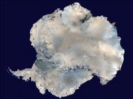
Veteran Explorer To Attempt The Coldest Journey On Earth. I'm feeling better about a Minnesota winter. Check out this story from
KAIT-TV in Jonesboro, Arkansas; here's an excerpt: "
Veteran polar explorer, Sir Ranulph Fiennes, will take on one of the last remaining polar challenges by attempting to cross Antarctica
in winter - the coldest journey on Earth - with five colleagues and
with the support of the Commonwealth and a number of sponsors. On 6 December 2012,
on board the expedition's South African ice-strengthened research
ship, 'SA Agulhas', the expedition team - led by Sir Ranulph - will
leave London, bound for Antarctica. Their aim is to complete 'The
Coldest Journey' - the first-ever trans-Antarctic winter expedition.
The Coldest Journey will also attempt to raise USD10 million
for Seeing is Believing, a global charitable initiative to fight
avoidable blindness. During their sea voyage, the team will undertake a
number of scientific tasks to provide unique data on marine life,
oceanography and meteorology. Using the very latest technological
innovations, this epoch-making journey will pave the way for a new dawn
in Antarctic, year-round exploration."
On This Date In Weather History (from the Twin Cities NWS office):
1998: 1 to 1 3/4 inch hail fell in Meeker, Wright, Todd, and Wilkin Counties winds were also estimated over 50kts.
1980: Golfball to baseball sized hail hit St. Paul. One company had 75 to 95 percent of the glass in their greenhouses smashed.
Football Weather.
It felt pretty good out there, with sunshine and a light breeze;
daytime highs ranging from 57 at Alexandria to 61 Twin Cities, and 62 at
St. Cloud.
Paul's Conservation Minnesota Outlook for the Twin Cities and all of Minnesota:
TODAY: Milder with patchy clouds, isolated shower. Gusty winds. Winds: W 15-25. High: 71
WEDNESDAY NIGHT: Isolated evening shower, then clearing. Low: 46
THURSDAY: Plenty of sun, pleasant. High: 66
FRIDAY: Next (stronger) clipper. Clouds, sprinkles possible. Low: 47. High: 59
SATURDAY: Mostly cloudy, windy & raw. Few showers. Low: 41. High: 56
SUNDAY: Slight risk of frost. More sun, turning milder by afternoon. Low: 35. High: near 60
MONDAY: Sunny, milder. Still too dry. Low: 47. High: near 70
TUESDAY: Blue sky, fine September weather. Low: 52. High: 69
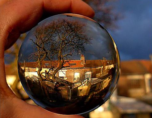
One Murky Crystal Ball
What will the winter be like? Easy, like last
year, or a snowy butt-kicker, like 2010-2011? The truth: if I knew (for
sure) I'd be sipping adult beverages on my own tropical island.
I'm not, by the way.
Record warming at the top of world may displace a
numbing "Polar Vortex" into the USA - OR - another warm, El Nino phase
may nudge the jet stream winds, blowing from the Pacific much of the
winter - a milder, drier pattern for Minnesota. It's an unsatisfying
answer, but it's too early to know.
Dr. Mark Seeley told me that 5 of the warmest 7
winters since 1895 have occurred since 1997 - 1998; looking at statewide
heating degree data. So the trends are warmer, no question. I believe
the odds of a "real winter" (65 inches or more of snow and 30+ subzero
nights) are probably less than 1 in 3.
It'll snow. It'll get cold. But Old Man Winter has been pulling his punch in recent years. When in doubt, go with the flow.
A mild Wednesday gives way to a couple more
clippers by late week. Expect a raw Saturday with 40s & 50s and
windblown showers. We may see frost in the suburbs early Sunday.
Keep jackets and shorts handy: I expect 3 or 4 days near 70F next week.
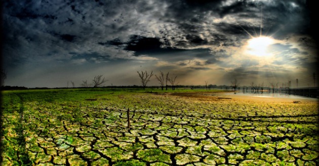
Our drought will get worse.
* photo credit above:
flickr.
Climate Stories...
How Fast Can Ice Sheets Respond To Climate Change? With the changes taking place in the Arctic (historic melting in 2012) I thought this article from
Eureka Alert was timely and relevant - here's an excerpt: "
BUFFALO,
N.Y. -- A new Arctic study in the journal Science is helping to
unravel an important mystery surrounding climate change: How quickly
glaciers can melt and grow in response to shifts in temperature.
According to the new research, glaciers on Canada's Baffin Island
expanded rapidly during a brief cold snap about 8,200 years ago. The
discovery adds to a growing body of evidence showing that ice sheets
reacted rapidly in the past to cooling or warming, raising concerns that
they could do so again as the Earth heats up. "One of the questions
scientists have been asking is how long it takes for these huge chunks
of ice to respond to a global climate phenomenon," said study co-author
Jason Briner, PhD, a University at Buffalo associate professor of
geology. "People don't know whether glaciers can respond quickly enough
to matter to our grandchildren, and we're trying to answer this from a
geological perspective, by looking at Earth's history."
Photo credit above: "
This shows Ayr Lake, Baffin Island, Canada.
UB geologists studying this remote region found that the island's
glaciers reacted rapidly to past climate change, providing a rare
glimpse into glacier sensitivity to climate events."
Credit: Jason Briner
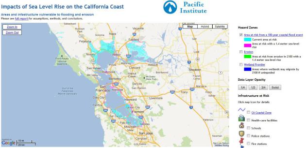
The Very Real Threat Of Sea Level Rise To The United States. Here's an excerpt of an article at
Huffington Post: "
Sea
levels are rising for two reasons: thermal expansion and an increase
in the volume of the ocean. As the planet warms, so do the oceans, and
warmer water takes up more space than colder water. As ice in glaciers
and the ice caps on Antarctica and Greenland melt, the volume of the
oceans grows. And we already see rising sea levels. Between 1993 and
the present, sea levels have been increasing an average of over 3 mm
per year -- more than 50 percent faster than over the past century.
Indeed, sea levels are actually rising at the upper range of model projections,
and there is growing concern that scientists have conservatively
underestimated the speed at which some of the massive ice volumes in
Greenland may deteriorate and melt. There is so much ice on Greenland
alone, that were it to melt into the oceans, sea levels would rise
nearly 24 feet. A global increase in sea level of a meter (more than
three feet) by the year 2100 is now "widely accepted as a serious
possibility" and even the U.S. Army Corps of Engineers recommends planning for as much as 1.5 meters (nearly five feet)."
Map above courtesy of
The Pacific Institute.
Study Estimates Increasing Rate of Extreme Rainfall With Global Warming. Here's a clip from
rdmag.com: "
Extreme
precipitation in the tropics comes in many forms: thunderstorm
complexes, flood-inducing monsoons and wide-sweeping cyclones like the
recent Hurricane Isaac. Global warming is expected to intensify extreme
precipitation, but the rate at which it does so in the tropics has
remained unclear. Now a Massachusetts Institute of Technology study has
given an estimate based on model simulations and observations: With
every 1 C rise in temperature, the study finds, tropical regions will
see 10% heavier rainfall extremes, with possible impacts for flooding in
populous regions. “The study includes some populous countries that
are vulnerable to climate change,” says Paul O’Gorman, the Victor P.
Starr Career Development Assistant Professor of Atmospheric Science at
MIT, “and impacts of changes in rainfall could be important there.”
Photo credit above: Tropical Storm Fay in 2008, courtesy of MIT.
Global Warming: Businesses See "Tangible And Present Risk". Here's a snippet from Climate Progress and
The Summit County Citizens Voice: "
The
number of large corporations reporting current risks from climate
change has grown substantially over the last two years. According to a survey
of 405 of the biggest global companies conducted by the Carbon
Disclosure Project, 37 percent say they are already seeing the impact of
climate change on their business — up from 10 percent in 2010. The
Carbon Disclosure Project attributes the increase in companies worried
about current climate risks to the rise in extreme weather
globally: "Recent extreme weather and natural events have tested
companies’ business resilience and increased their level of
understanding of the timeframes of the physical risks they associate
with climate change..."
Are Hurricanes Linked To Global Warming? The best
available evidence suggests that a warmer atmosphere (and ocean) may not
result in more hurricanes, but the storms that do spin up may have a
greater chance of becoming major, Category 3 plus storms. Details from
Mother Nature Network; here's an excerpt: "
Hurricanes are often seen as heralds of global warming,
which makes sense. They're fueled by warm seawater, and the warming of
Earth's oceans coincides with a recent spike in hurricane activity.
Plus, scientists have grown increasingly confident that global warming —
caused by greenhouse gases in the atmosphere, including those emitted
by human activities — raises the risk of severe weather.
But has global warming already started affecting hurricane intensity?
Can the planet's climbing temperatures help explain monster storms like
Hurricane Katrina? Those are tricky questions, but the world's top
climate experts are hard at work trying to answer them. One of those
experts is Thomas R. Knutson,
a research meteorologist with the U.S. National Oceanic and
Atmospheric Administration who studies Atlantic hurricane activity and
the impacts of greenhouse gas-induced warming."
Photo credit above: "
Hurricane Katrina approaches the U.S. Gulf Coast on Aug. 28, 2005." (Photo: NOAA)
Government Study: Climate Change Boosted "Unprecedented Drought". This story from
rawstory.com is focused on record drought across Australia; here's an excerpt: "
An
Australian government study published Friday claims to establish a
direct cause-and-effect relationship between man-made climate change
and the country’s recently ended decade of “unprecedented” drought.
While the study establishes a link between climate change and drought,
authors of the South Eastern Australian Climate Initiative’s synthesis report
(PDF) said the changes forecast by their research point to weather
systems becoming much more erratic and rainfall scarce across
south-eastern Australia as the average annual temperature rises. The
study began with urgency in 2006, amid Australia’s so-called Millennium
Drought, which got underway in 2001 and didn’t abate until 2010, then
the country saw record rains a major typhoon that brought devastating
floods."
Computer Models For Global Warming May Be Over-Estimating The Risk of Drought. The story from
inhabitat.com; here's an excerpt: "
One
might think that as the planet gets warmer and soil becomes more
parched, droughts would become more common. However according to new
research from Britain’s Centre for Ecology and Hydrology the opposite may be true. The UK team published a study in Nature this week stating that as soil becomes more parched, afternoon storms are more likely to develop, meaning that droughts are less likely to occur."
What Drove Early Man Across Globe? Climate Change. Here's a snippet of an article at
NPR: "
Anthropologists
believe early humans evolved in Africa and then moved out from there
in successive waves. However, what drove their migrations has been a
matter of conjecture. One new explanation is climate change.
Anthropologist Anders Erikkson of Cambridge University in England says
the first few hardy humans who left Africa might've gone earlier but
couldn't. Northeastern Africa — the only route to Asia and beyond — was
literally a no man's land. "The people couldn't really couldn't
leave," he says. "The climate was too arid and too hot, so humans were
bottled up."
Breaking Up The Echo. Here's an excerpt of a
New York Times Op-Ed that caught my eye: "...
Balanced
presentations can fuel unbalanced views. What explains this? The answer
is called “biased assimilation,” which means that people assimilate
new information in a selective fashion. When people get information
that supports what they initially thought, they give it considerable
weight. When they get information that undermines their initial
beliefs, they tend to dismiss it..."


No comments:
Post a Comment