88 F. high in the Twin Cities Sunday.
72 F. average high for September 2.
82 F. high on September 2, 2011.
Isolated T-shower today (best chance south of the metro, over far southern Minnesota).
2012: warmest year on record, to date, since modern day records started in 1891.
 Today's Dew point prediction:
7 am: 64 F. (still sticky)
7 pm: 52 F. (much more comfortable)
Tuesday night: best chance of showers and possible thunder as cooler air finally arrives.
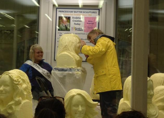 Last Day
to eat yourself into a food coma out at the Minnesota State Fair. The
only one staying cool yesterday was Princess Kay of the Milky Way in the
Dairy Building. It was hot and dusty out at the State Fairgrounds
yesterday. Yes, we need rain, preferably at night, preferably tomorrow.
There's a very slight chance of thunder today, a better chance closer to
the Iowa border. The next chance of (widespread) showers and T-storms
comes Tuesday night ahead of a cool front.

“
We don’t have much skill in forecasting drought development,” he
said. One reason for this, scientists say, is that the computer models
forecasters use don’t accurately capture the ways that land surface
conditions interact with the atmosphere. The models tend to have more
skill in predicting drought development or tendency out to a few weeks
in advance, but beyond that, they have major limitations." - from a story at Climate Central; details below. Photo: AP.
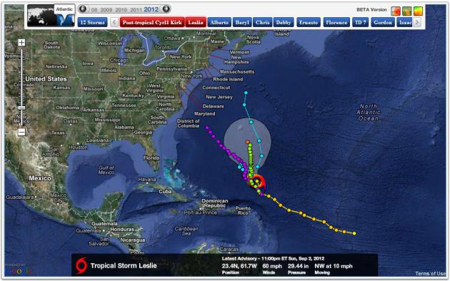 "Leslie".
The latest tropical storm northeast of Puerto Rico is forecast to
become a hurricane, possibly threatening Bermuda by the end of the week.
Odds favor a turn out to sea, but a few models are pulling Leslie
closer to the east coast of the USA. Map:
NHC and Ham Weather.
Thank You September. It's been the warmest year on
record for much of Minnesota, temperatures 2-5 F. warmer than average.
It's also been the warmest 12 months on record. Details below.
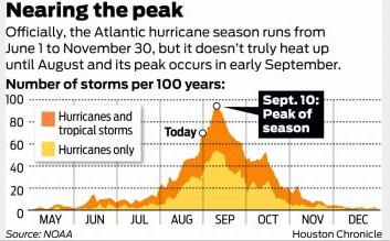
September 10. Date when hurricanes are most likely to strike the USA mainland. We are almost halfway thru hurricane season.
Twin Cities: Warmest Year To Date On Record. 2012 is
turning out warmer, to date, than 1987 or 2006, the previous records
for warmest years. St. Cloud and Eau Claire are also having their
warmest year. Details from the Twin Cities
NWS.
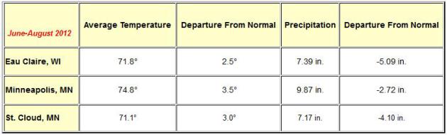
Meteorological Summer. Temperatures from June 1 thru
the end of August ran 3.5 F. warmer than average in the metro, nearly
3" drier than average. Source: Twin Cities NWS.
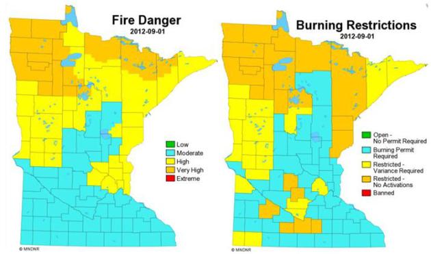
Growing Fire Danger. The Minnesota DNR is tracking
very high fire danger over far northern Minnesota; burning restrictions
are in place, statewide. (upper right).
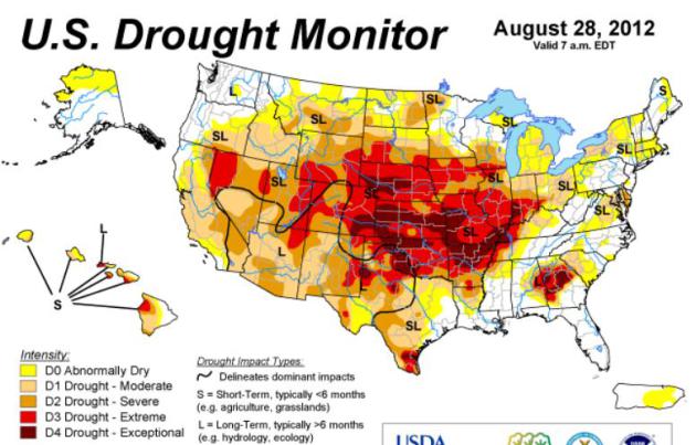
Lack Of Warning On Drought Reflects Forecasting Flaws.
There are limits to how well we'll ever be able to predict devastating
droughts in advance. It's true that La Nina patterns (Pacific cooling
phases) often nudge the jet stream into a pattern that favors drought
for the southern USA, but it's a sometimes unreliable signal. More on
the limits of drought prediction from
Climate Central meteorologist Andrew Freedman: "
In
May, the U.S. Agriculture Department predicted a record corn yield
after farmers planted the largest area of corn and soybeans since 1937.
Three months later, after a searing drought engulfed a wide swath of
the continental U.S., those crops lie in ruin. Despite all of the
resources at forecasters’ disposal, the worst drought to strike the
U.S. in nearly 50 years came on largely without warning across the
fields of the Midwest and High Plains during late spring and early
summer. Between May 1 and July 24, the drought footprint in the lower
48 states expanded from an already high 38 percent to a devastating 64 percent,
engulfing more than a dozen states in the process, including nearly
the entire corn and soybean growing region. Judging by past droughts,
the drought of 2012 will likely cost the U.S. somewhere on the order of
tens of billions of dollars."
* the latest U.S. Drought Monitor is
here.
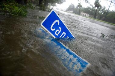
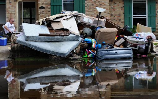
Hurricane Isaac Highlights Gaps In Flood Protection, U.S. Senators Say.
NOLA.com has the story; here's an excerpt: "
A
group of high-ranking elected officials and top Army brass Saturday
hailed the first major test of the New Orleans metropolitan area's new flood protection system during Hurricane Isaac
as a heartening success. But they attached several sobering caveats to
their celebratory speeches during an afternoon news conference
overlooking the Mississippi River....Even though the officials spoke at
length about needed improvements, they also devoted considerable time
to praising the metropolitan area's new system, which cost about $14.6
billion. Col. Edward Fleming, commander of the corps' New Orleans
district, said "we clearly would have had overtopping of floodwalls" if
Hurricane Isaac had hit before the new system was in place. He said
storm surge that came up as high as 14 feet on the flood defense
system's new 26-foot barrier would have spilled over old barriers."
Photo credit above:
Cheryl Gerber, The Associated Press. "U.S.
Senator David Vitter, R- La., left, Jefferson Parish President John
Young, second left, Louisiana Gov. Bobby Jindal and Army Corps of
Engineers Col. Ed Fleming, right, tour the new levee wall and pumps at
the 17th Street Canal in New Orleans on Tuesday."
Hurricane Isaac Storm Surge Reversed Flow Of Mississippi River. Just when you thought you'd read everything about Isaac, along comes this story from
The Christian Science Monitor; here's an excerpt: "
As hurricane Isaac reached southeastern Louisiana as a Category 1 storm earlier this week, it did something unusual to the Mississippi River: It threw the river into reverse. For nearly 24 hours, according to the US Geological Survey,
Isaac's storm surge drove upriver at a pace nearly 50 percent faster
than the downstream flow. This backflow produced a crest some 10 feet
above the river's prestorm height at Belle Chasse, La., in
flood-beleaguered Plaquemines Parish southeast of New Orleans. The surge added eight feet to the river's height at Baton Rouge,
father north. Isaac had help. A scorching, rain-starved summer in the
middle of the country sent river levels to lows not seen since a
similar drought struck the region in 1998, easing the Mississippi's flow."
Photo credit above: "
High winds from hurricane Isaac toppled signs and caused flooding and power outages in New Orleans Wednesday." Ann Hermes/The Christian Science Monitor.
We're Almost Over The Hurricane Hump For This Storm Season.
The date you probably want to avoid a Caribbean cruise is September 10.
That's the day when landfalling hurricanes are most likely to strike
the USA. More details from
The Houston Chronicle: "
When
Tropical Storm Leslie developed Thursday, this Atlantic hurricane
season jumped ahead of the record-setting 2005 season in its count of
named storms. That's because the 12th named storm in 2005, Tropical
Storm Lee, didn't form until Aug. 31. But the comparison ends there.
Just like Hurricane Isaac was no Katrina, most of this year's other
tropical storms and hurricanes have been pale imitations of their 2005
counterparts. That year, in July alone, Category 4 Hurricane Dennis
became the strongest hurricane ever in July. A week later, Emily became
the first Category 5 hurricane in July."
$2 billion in damage from Hurricane Isaac? Details from Bloomberg Businessweek below.
"...
The fact is, many people lack the resources to escape. Having
no money, no mode of transportation and no friends or family in safe
places means no choice but to weather the storm." - from an NBC News story on why some people won't (or can't) evacuate to a safe spot before a hurricane.
Photo credit above: "
A man makes his way down a flooded
street in a boat in the aftermath of Isaac Friday, Aug. 31, 2012, in
Ironton, La. Isaac is now a tropical depression, with the center on
track to cross Arkansas on Friday and southern Missouri on Friday
night, spreading rain through the regions." (AP Photo/John Bazemore)
Hurricane Isaac May Cost Insurers $2 Billion; AIR Says. Details from
Bloomberg Businessweek; here's an excerpt: "
Isaac,
the storm drenching Arkansas after making landfall in Louisiana as a
hurricane, may cost insurers as much as $2 billion in the U.S.,
risk-modeling firm AIR Worldwide said. The industry’s claims costs,
including wind and storm-surge damage to residential, commercial and
industrial onshore properties, will be at least $700 million, the
Boston-based firm said today in an e-mailed statement. The estimates are
a fraction of the $41.1 billion cost for Hurricane Katrina, the 2005
storm that struck Louisiana and caused flooding in New Orleans.
Hurricane Irene, which lashed the U.S. East Coast last year, cost $4.3
billion."
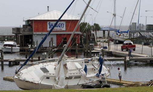
Photo credit above: "
Two sailboats, the Sweet Dreams,
foreground and the Caribe, were swept from their docks by Hurricane
Isaac to the parking lot in front and beside Shaggy's at Pass
Christian, Mississipi, on Friday, August 31, 2012." (Tim Isbell/Biloxi Sun Herald/MCT)
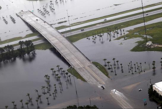
149 Photos Capture Isaac's Fury.
Huffington Post
has a good recap, and there's only so much you can convey about a
hurricane via text. The photos tell the story in a way no narrative ever
will. Many locals, officials and members of the media didn't pay Isaac
the respect it was due. Intensity (the "category" of the storm) is
important when estimating storm surge coming ashore, but in the end the
track and forward speed of the storm is even more important when
calculating the duration of the storm surge and total rainfall amounts.
Isaac stalled, stuttered and sputtered, hitting Louisiana twice as a
Category 1 hurricane, but that big, lazy loop prolonged the extreme
rains (and 8-12 foot storm surge), allowing a Category 1 storm to create
damage more typically found in a Category 2-3 hurricane. More details: "
As Gulf Coast states began to assess the damage from Hurricane Isaac, photos and video started to trickle in of the devastation. Although the death toll has been minimal compared to Hurricane Katrina, fatalities have occurred, and damage was extensive in some regions. Rising floodwaters from Isaac have forced thousands of evacuations, catching many by surprise, reported the Associated Press. Pictures of Isaac's impact
reveal residents and homes caught in flood conditions. Up to half of
Louisiana was left powerless on Thursday, and hundreds of thousands were
in the dark in Mississippi."
Flooding Spreads North. Jalen Brown captured this photo of severe flooding at Pine Bluffs, Arkansas Friday. Pic via
Twitter.
Isaac's Leftovers. Moisture leftover from Hurricane
Leslie continues to spark flooding rains from the Ohio Valley into the
Carolinas and Virginias, a few tornadic storms reported over Mississippi
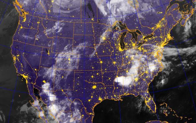
and Alabama Sunday. IR satellite image:
Naval Research Lab.
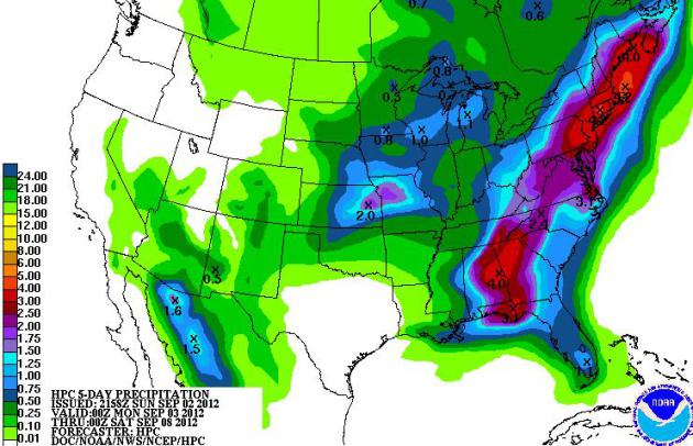
New England Flood Potential.
NOAA HPC prints out some 3-5"+ rainfall amounts from New England into
New York City and the Delaware Valley, another area of 2-4" rains over
the next 5 days across Georgia and Alabama.
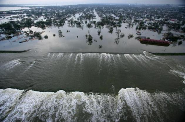
Billion Dollar Flood-Protection System Around New Orleans Proves Reliable.
It passed the first test, a Category 1 hurricane. Will it withstand a
Category 4 or 5? We'll see, but so far so good, as reported by
The Washington Post; here's an excerpt: "
Seven
years ago, the Army Corps of Engineers was desperately trying to plug
breaches in the city’s broken and busted levee system. Since those
catastrophic days, the Army Corps has worked at breakneck speed — and
at a cost of billions of dollars — to install new floodgates, pumps,
floodwalls and levees across New Orleans. The work paid off. A day
after Isaac hit New Orleans on the seventh anniversary of Katrina,
officials said the 130-mile flood protection system did its job."
Photo credit above: Vincent Laforet, Pool, File - Associated Press). "
In
this Aug. 30, 2005 photo, floodwaters from Hurricane Katrina pour
through a levee along Innter Harbor Navigational Canal near downtown New
Orleans, LA, a day after Katrina passed through the city."
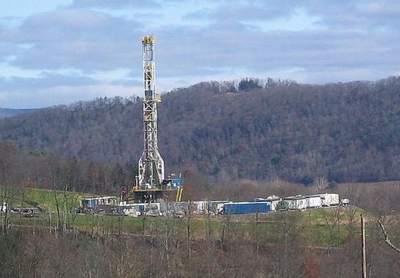
Hurricanes Don't Scare Natural Gas Anymore. Fracking
has changed the equation; gas and oil prices no longer spike (as much)
when a hurricane is churning into the Gulf of Mexico, littered with
drilling rigs.
Marketwatch explains: "
Even
with much of the Gulf of Mexico’s energy production shut down as
Hurricane Isaac approached the region earlier this week, the
natural-gas market barely blinked — and that’s exactly what analysts
said would happen. “Natural gas did not react like it has in previous
storms because, with the rapid development of shale gas over the last
several years, the Gulf is increasingly less important to overall gas
supply,” said Kim Pacanovsky, managing director and senior research
analyst for oil and gas at MLV & Co. in New York. As of Thursday,
about 72.5% of the current daily natural-gas production in the Gulf was
shut-in because of Isaac, according to U.S. government data. Price
action in natural-gas market over the past few days, however, indicates
just how little concern the market has for the production disruption."
Storm Psychology: Why Do Some People Stay Behind? Great question, and
NBC News
does a good job providing credible reasons why many people can't (or
won't) evacuate to higher ground in advance of a hurricane. Here's an
excerpt: "
It’s the question so many of us have while watching news coverage of
a hurricane or tropical storm like Isaac: Who are these people who
don’t leave home even as an angry storm is advancing – and what are they
thinking?! The short answer: For some, the up-and-leaving idea isn’t
as easy as it sounds to those of us watching from a safe and dry
distance. Actually, a 2009 article published in the journal Psychological Science
sought to examine the reasons some people won’t evacuate, despite the
urging or even mandates of city and state officials, by asking a group
who would know: Hurricane Katrina survivors who weathered the storm at
home."
Photo credit above: "
Tony Miranda takes a break from
clearing out his home after it was flooded by Hurricane Isaac in
LaPlace, La., Friday Aug. 31, 2012." (AP Photo/The Advocate. Arthur D. Lauck)
Site Suggestion: American Weather. If you're interested in digging into the meteorology behind "Isaac" check out this web site,
American Weather.
Estimating hurricane landfall is still as much an art as it is a
science - which model do you believe? Do you put your trust in an
ensemble of models, a weighted average, or go on a limb with a favorite
simulation? If you're a true weather geek (um..enthusiast) you'll like
this one. Thanks to Randy Peterson for teeing this one up!

"Ask Paul". Weather-related Q&A:
Hello Paul!
I’m a big fan of your blog and MN sunny days. Now
the question… I live in Champlin (TC) and I’ve already noticed that a
part of my Maple tree is changing colors as well as the Sumacs and
Weigelia bushes but at the same time the summer flowers are still going
strong, meanwhile, the critters are shedding like crazy and the geese
look like they are getting ready to head south… So do you think we’re
heading for an early fall colors (since we had such an early Spring) or
is all part of my crazy imagination… ???
Sincerely confused,
Marianella
Marianella - I have never seen any research
suggesting that leaves ripening early is in any way a predictive tool
for the autumn or winter to come. In reality those yellow sugar maples
are probably a reaction, to a lower sun angle coupled with unusually
cool nights in mid-August, and most important: a growing drought across
southern Minnesota. If it snows in mid-September (highly doubtful)
you'll be able to tell me "told you so!"
Hi Paul,
What is your prediction for this winter, 2012-2013? Warmer, less snow?
Thank you, you are the best!
Cate Murphy
Thanks
Cate - you may not feel that way after you get my forecast, more gut
feel than anything based on science. Winters have been trending milder,
with less snow in recent years. That's hardly breaking news. It seems 1
in 4 or 1 in 5 winters is a "real, butt-kicking Minnesota winter" with
significant cold and snow. We're heading into an El Nino, which
correlates with milder temperatures and somewhat less snow for
northern-tier states. I suspect we'll see more snow than last winter (22
whopping inches in the metro), but less than 2010-2011, when 86" fell.
My hunch: 40-50" snow; colder than last winter, but not as severe as two winters ago. Time will tell.
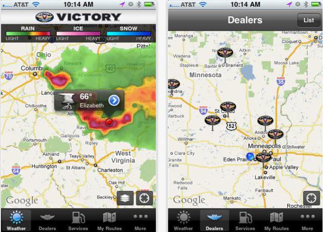
In
his weather page in the Star Tribune a couple of weeks ago Paul
mentioned 2 weather apps he liked best. One he had done but no longer
gets money from, and another one. I wrote them down and have lost the
paper. I would appreciate it if you would send me these names.
Thanks.
Sue Stover
Sue
- my favorites are My-Cast Weather Radar (which sends out severe
weather alerts in addition to Doppler radar and even lightning strike
data (for a surcharge). The other is RadarScope, which is still the best
Doppler app out there, in my humble opinion. Neither is free, but if
you're a weather enthusiast you'll get your money's worth. Full
disclosure: My-Cast was my previous company,
which we sold to Garmin in 2007. I no longer have any involvement with
the company and don't receive any $$ for recommending the app. But it's
partially my baby, and I'm happy to see it getting so much national
attention. The team at Digital Cyclone has done an amazing job upgrading
the app and keeping it current. I would add one more (free) app
to the list: "Victory Rides" for Polaris, which is a current client.
Again, the app is free - we receive no compensation for the sale of this
app on the iTunes store. Good luck!

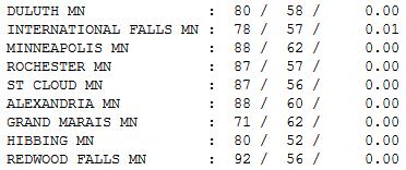
Summer Flashback.
Technically it's meteorological autumn. Historically, the warmest 90
days of the year runs from June 1 to September 1. But Sunday felt like
late July, highs in the 80s statewide, even some low 90s over
southwestern Minnesota. Highs ranged from 71 at Grand Marais to 87 St.
Cloud, 88 Twin Cities and a 92 Redwood Falls.
Paul's Conservation Minnesota Outlook for the Twin Cities and all of Minnesota
LABOR DAY: Intervals of sun,
still humid. Passing shower or T-storm possible, especially south of
MSP. Dew point: 64. Winds: SW, becoming NE 5-10. High: 87
MONDAY NIGHT: Partly to mostly cloudy, an isolated shower. Low: 69
TUESDAY: Unsettled and very warm. Best chance of a T-storm Tuesday night. Dew point: 57. High: 89
WEDNESDAY: Early shower, then clearing, breezy and cooler. Dew point: 47. Low: 67. High: 79
THURSDAY: Clouds increase, cooler. Dew point: 53. Low: 58. High: 76
FRIDAY: September-like. Stray shower? Low: 56. High: 72
SATURDAY: Cool sun, fresh breeze. Dew point: 51. Low: 55. High: 73
SUNDAY: Sunny and milder. Low: 56. High: 75
* Long-range model guidance shows 80s returning to Minnesota the week
of September 9; I wouldn't be surprised to see a 90-degree high or two.

50 Shades of Baffled
"This drink's on me" the server at the 331 Club in Minnapolis said Saturday. "Just promise me a nice, long Indian Summer." Done.
There is some precedent for saying this. 1).
We're sliding into an El Nino warming phase of the Pacific. 2). A
warming climate has lengthened our autumns in recent decades. According
to Dr. Mark Seeley the last 10 Novembers have been "warm enough to play
golf in November", which he called "historically unprecedented".
If only I could play golf.
Ice forms on lakes later each year (ask any ice
fisherman). Many years we don't have to drag out heavy parkas and gloves
until December.
Our winter outlook is an enigma wrapped in a
riddle, boxed up in a mystery. Anyone who tells you they have it all
figured out is trying to sell you something.
We've salvaged a fairly extraordinary holiday
weekend, but a weak frontal boundary may spark a few showers and
T-showers today. Best chance? Early morning, again around the dinner
hour. I expect enough midday sun for upper 80s.
We cool off this week; it'll feel like September
in 3 days. But long range guidance brings another surge of heat into
Minnesota next week. A few more 90s in September?
Count on it.
Climate Stories....
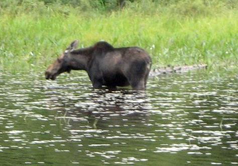
Minnesota Moose Mystery: Is Climate Change Killing This Icon Of The North? This isn't the first I've heard this theory. More details from
treehugger.com; here's an excerpt: "
It
seems like every third business in Northern Minnesota has "moose" in
its name, reflecting the importance of the iconic mammal on local
culture. But if current trends continue, the word on commercial signage
may be the only trace left of the moose population in northern
Minnesota. An unexplained population crash in the northwestern corner
of the state has led to the near extinction of the moose in that
territory. Naturalists fear that moose in the northeastern quadrant are
following the same pattern. Finding answers rivals a crime scene
investigation, as the Department of Natural Resources (DNR) and
Minnesota moose lovers seek answers that can help put a stop to further
moose deaths."
Photo credit above:
Colin McMillen/CC BY 2.0
New AMS Statement on Climate Change. Here are more details (and the complete text from AMS) courtesy of The
American Geophysical Union Blog: "
The
AMS has released it’s updated statement on climate change, and as
expected, it is considerably more direct than the previous one issued
in 2007. This is no surprise since the last 5 years have seen
a remarkable increase in understanding, along with 5 more years of
observations and measurements. Full disclosure here: I’ve been a proud
member of the American Meteorological Society for around 35 years. I
also serve on the AMS Committee for Station Science. For
someone wanting a non-political look at what we know, I
highly recommend reading the statement. It’s well done and to be honest
on the conservative side. A good example is the portion that talks
about sea level rise of 10-28 inches. If sea level continues to rise
only at the rate it is rising now it will exceed 10 inches. The next
IPCC summary of the science will (from everything I’ve read over the
past year or so) forecast a likely rise of over a foot by the end of
this century. "
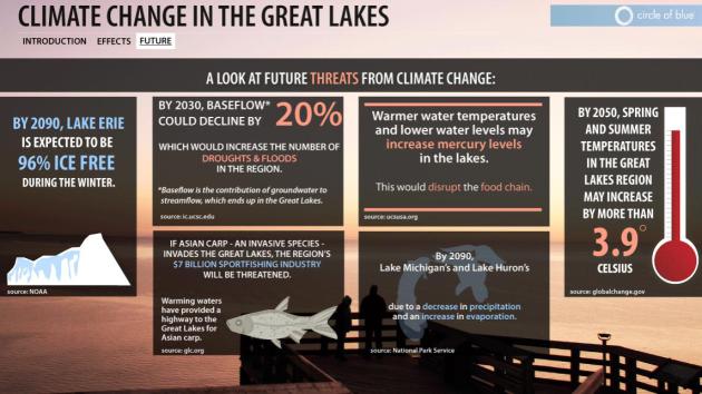
Climate Change In The Great Lakes. Here's an interesting infographic from
Circle of Blue Waternews.
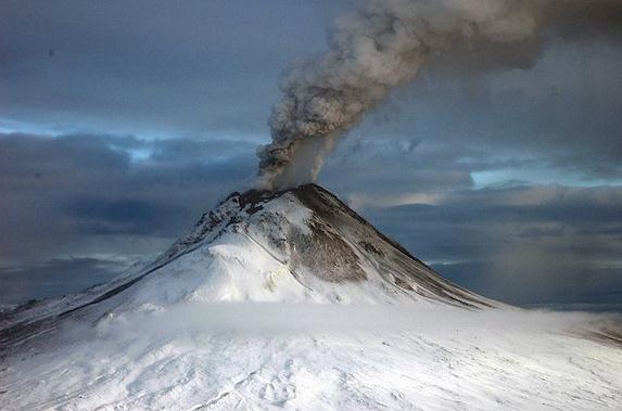
Is Geoengineering The Answer To Climate Change? Tinkering with the atmosphere - what can possibly go wrong? Here's an excerpt of an interesting article at
Smithsonian Magazine: "
Climate change used to be thought of as a long-term worry; now, there’s good reason to believe we’re already encountering its effects.
As the problem grows more urgent, some say we ought to take a radical
approach: Instead of struggling in vain to limit greenhouse gas
emissions, we should try to engineer systemsto
directly stop the warming of the planet. This approach is known as
geoengineering, and it might be the most controversial area in climate
science. The term encompasses a wide variety of techniques. One company
tried to fertilize the ocean with iron, to encourage the growth of algae to absorb excess carbon dioxide. Other scientists have suggested spraying clouds with seawater
to increase their whiteness—and thus reflectivity—reducing warming by
bouncing light back out to space. The U.S. government has even
considered gigantic, sun-blocking mirrors in outer space as a last-ditch option if climate change hits a tipping point."
Photo credit above: "
Geoengineering could replicate the cooling effects of a massive volcanic eruption as a tool to reduce climate change." Photo via Wikimedia Commons
GOP Platform Highlights The Party's Abrupt Shift On Energy, Climate. Here's an excerpt from
The Washington Post: "
Over
the past four years, the Republican Party has undergone a fairly
dramatic shift in its approach to energy and environmental issues.
Global warming has disappeared entirely from the party’s list of
concerns. Clean energy has become an afterthought. Fossil fuels loom
larger than ever. And one way to see this shift clearly is to compare
the party’s 2008 and 2012 platforms. It may seem difficult to believe
now, but back in 2008, the Republican Party’s platform (pdf) had a long and detailed section on “Addressing Climate Change Responsibly.” Here’s how it opened:
"The same human economic activity that has brought freedom and
opportunity to billions has also increased the amount of carbon in the
atmosphere. While the scope and longterm consequences of this are the
subject of ongoing scientific research, common sense dictates that
the United States should take measured and reasonable steps today to
reduce any impact on the environment. Those steps, if consistent with
our global competitiveness will also be good for our national security,
our energy independence, and our economy."
Photo credit above: "
No longer a Republican concern." (JOHN MCCONNICO / AP)


No comments:
Post a Comment