92 F. high in the Twin Cities Monday, 5 degrees shy of the all-time record of 97, set in 1925.
77 F. average high for September 3.
81 F. high on September 3, 2011.
29 days at or above 90 F. this year. Average for MSP is 13 days.
90+ highs possible again today, the last 90-degree high in sight.
.24" rain predicted tonight in the Twin Cities (00z NAM model).
"Leslie" posing a threat to coastal New England within a week? Details below.
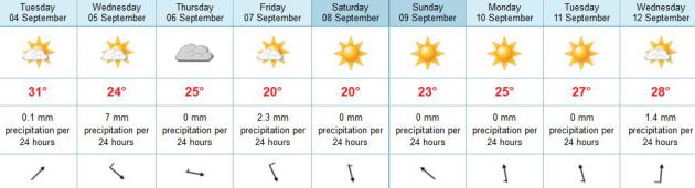
Meteogram. After peaking near 90 again today,
temperatures drop off noticeably Wednesday; the best chance of showers
and T-storms late tonight and early Wednesday morning. South winds today
become northwest tomorrow as dew points drop off behind a cooler front.
September At Its Best. After one more hot day today,
temperatures drop off - highs in the upper 60s and low 70s by Friday
and Saturday. Right now the weekend weather forecast looks encouraging,
comfortable sun both days; Sunday the warmer day. We should hit 80+
again the first half of next week before a more significant cold front
by the end of next week.
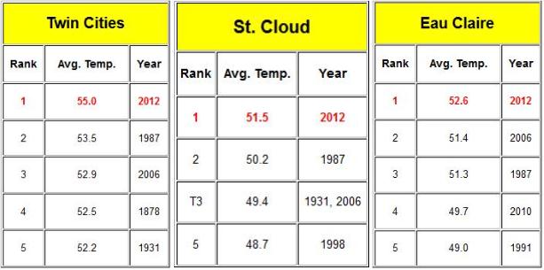
2012: Warmest Year On Record, To Date. As of
September 1, the end of "meteorological summer", the Twin Cities, St.
Cloud and Eau Claire were all experiencing the warmest year on record
(since the late 1800s). Summer details from the local
Twin Cities NWS office: "
Summer
2012 will be remembered as one of the hottest on record. Much of the
region saw temperatures well above normal thorughout much of the summer,
especially July. The summer was alos dry across most of the area, as
drought conditions persisted in many locations. The historic flood in
northeast Minnesota that occurred in June skewed the summer data for
that area, which did end up seeing above normal precipitation for the
season, not surprisingly. For the Twin Cities it was the 3rd warmest summer on record. July, 2012 was the 2nd warmest month on record in the Twin Cities,
so even with a nearly average August and moderately above normal June,
the month of July pushed Summer 2012 into the top 3 warmest on record."
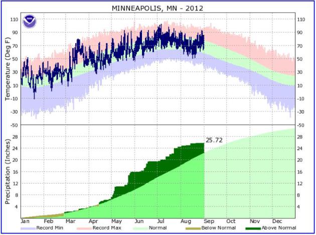
A Year To Remember. More details on 2012 from the Twin Cities National Weather Service: "
Above
is a graph showing temperature and precipitation from the beginning of
the year until the end of August for Minneapolis/St. Paul. Note the
record temperatures in March, the large jump in cumulative rainfall
totals in May, and the very hot July."
“
I believe the world is getting warmer… And number two, I believe
that humans contribute to that… So I think it’s important for us to
reduce our emissions of pollutants and greenhouse gases that may well
be significant contributors to the climate change and the global
warming that you’re seeing.” - Mitt Romney, June, 2011.
"
About half the carbon pool in soil globally is held in
permafrost in the Arctic, a region that is experiencing twice the
global average of climate warming, said the study led by researchers at
Stockholm University." - from a story at The Australian below.
101 F. high at Dallas and Waco, Texas on Monday.
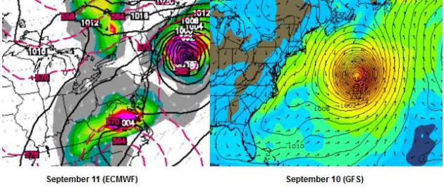
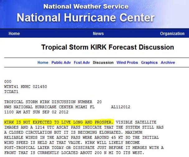
Too Close For Comfort. Although the GFS model is
steering Hurricane Leslie well away from the U.S. mainland, on a course
that may brush the Canadian Maritimes, the (usually more reliable)
European ECMWF model brings Leslie's fierce winds much closer to New
England in about 7 days. This far out it's truly anyone's guess, but if
you have friends or family in New England you may want to encourage them
to keep an eye on Leslie in the days to come. More details from
NHC.
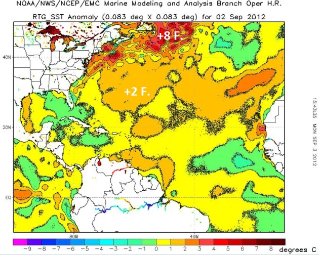
Sea Surface (SST) Anomalies. The map above shows the departure
from normal. What is unusual, almost unprecedented, is the huge area of
sea surface temperatures in the North Atlantic running 6-9 F. warmer
than average for early September, the result of historic warmth over the
northern hemisphere this summer. Normally when hurricanes push north
into colder ocean water they weaken rapidly. That may not be the case
with “Leslie”.
Official Track. Right now most of the computer simulations
sweep Leslie harmlessly out to sea, a threat to ships and whales. But
I’m putting more weight on the ECMWF model, which tends to do a better
job 7+ days out. We need to see a few more model runs, but if the
ECMWF is on the right track, New England may see more of Leslie than
they bargained for. Stay tuned...
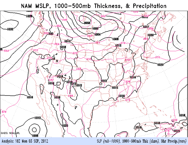
NAM Solution. Much of today should be dry, the best
chance of showers and T-storms late tonight and Wednesday morning ahead
of an advancing cool front. On screen right you can watch Hurricane
Leslie coming into view, tracking toward the north/northwest. Bermuda
may feels the effects of Leslie by late week. Loop: NOAA.
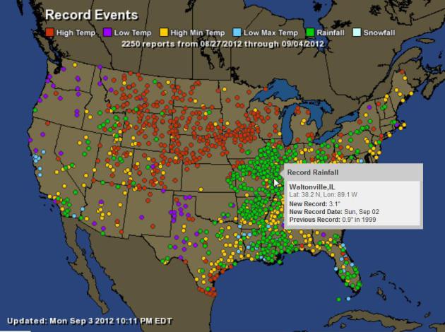
2000+ Daily Weather Records In The Last Week. On this
interactive map
from Ham Weather you can see the impact of Isaac, 24 hour rainfall
records broken from the parishes of Louisiana into Ohio and even
Pennsylvania; more record heat from the Great Lakes and Upper Midwest
into the northern Rockies.
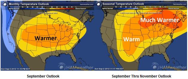
Extended Outlook: Warm Bias Continues. Based on a
strengthening El Nino (warming phase of the equatorial Pacific Ocean
waters) NOAA CPC is predicting not only a warmer than average September,
but warmer than normal temperatures into November. Maps:
Ham Weather.
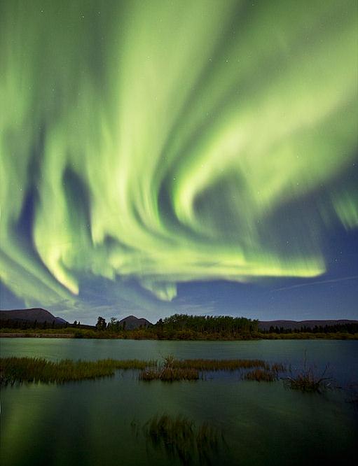
"Northern Lights Watch" There is no way to predict
an aurora in advance. All we can do is track what's happening on the
sun, which is becoming increasingly busy and stormy with more numerous
solar flares (CME's). The chance of seeing the Northern Lights from
Minnesota should increase this week, but we can't get any more specific
than that. More details from
spaceweather.com:
" As expected, a coronal mass ejection
hit Earth on Sept. 3rd at approximately
1200 UT (5 am PDT). The impact induced
significant
ground currents
in the soil of northern Scandinavia and
sparked bright auroras around the Arctic Circle.
A moderate geomagnetic storm is
underway.
Photo credit above: "Jonathan Tucker photographed
this display over Whitehorse in the
Yukon Territories during the early hours
of Sept. 3rd."
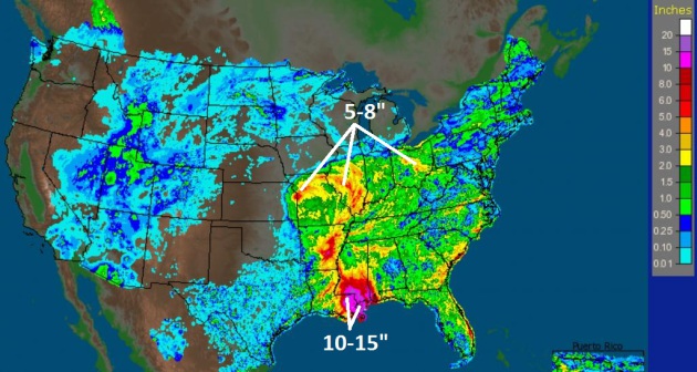
Isaac Brings Touch of Relief, And Hope For Next Season, to Corn Belt. It was too late for farmers worried about their 2012 crop, but the jolt of rain from Isaac may help in 2013, as reported by
The New York Times; here's an excerpt..."
Isaac’s
rains may fortify younger soybean plants whose leaves are not already
jaundiced, allowing the beans to plump up. It should help farmers sow
winter wheat this month, and it should help revive the pastures where
cattle have been grazing on nubs of dead grass. But it will take weeks
to measure the rain’s effect on late-summer crops, and even longer to
know whether the storm offered anything more than a teasing break from
the drought. The government’s latest assessment of the record-breaking
drought, released before the shards of the hurricane moved north from
the Gulf Coast, contained only the tiniest hints of improvement."
* 7-Day Doppler-derived rainfall estimates courtesy of
NOAA.
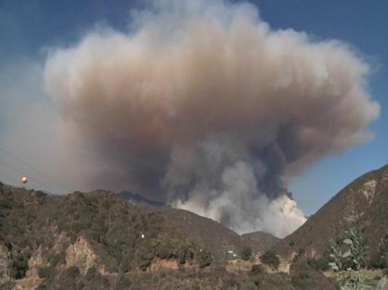
Smoky Mushroom Cloud. Thanks to Brad Mack, who
captured this photo of the blaze that has already engulfed 4.000 acres;
the Azusa Canyon Williams Brushfire at Angeles National Forest in
California. I sense it's going to be a very long fire season out west.
More from NBC News
here.
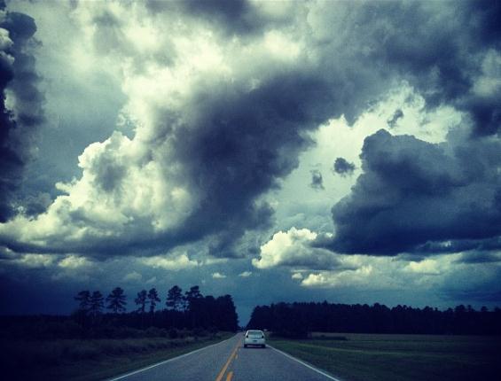
A Ragged Sky. Emilee McDaniel captured this photo of
an ominous sky above Jackson Springs, North Carolina on Labor Day.
Thanks to WeatherNation TV for passing it along.
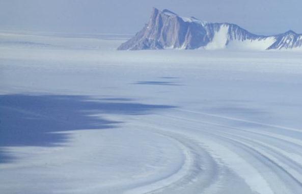
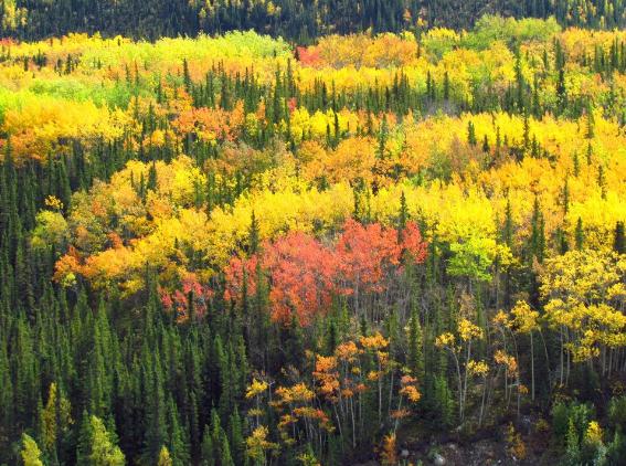
The Wonders of Denali. Photo courtesy of the Denali National Park and Preserve.
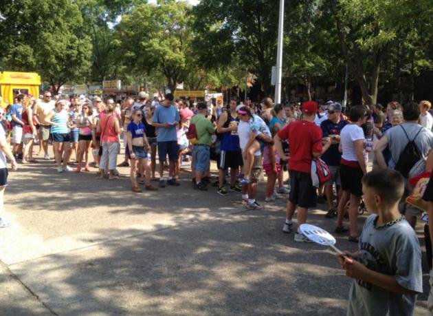
A Long Line At The Star Tribune Booth At The State Fair.
Were these people in line to get my autograph? You sorry old fart -
guess again. Sunday afternoon, a throng of people, hundreds, stood in a
hot sun for 30-45 minutes for....wait for it...
Pickle-Flavored Lip Balm. That's right. Lip balm.
Because you can never have enough pickle-flavored lip balm. It was one
of several surreal moments at the fair this year. Another was watching
clouds of dust and smoke swirling around, a mini-Dust Bowl. Yes, it's
getting dry out there. Here, put a little pickle-flavored lip balm on
those hot, chapped lips...
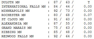
What September? Yes, it felt like July out there
yesterday, 92 in the Twin Cities with dew points falling thru the 60s
into the 50s - so it felt more tolerable as the day went on. Rochester
picked up .07" rain. Statewide highs ranged from 75 at Grand Marais to
91 St. Cloud, 92 Redwood Falls and the Twin Cities.
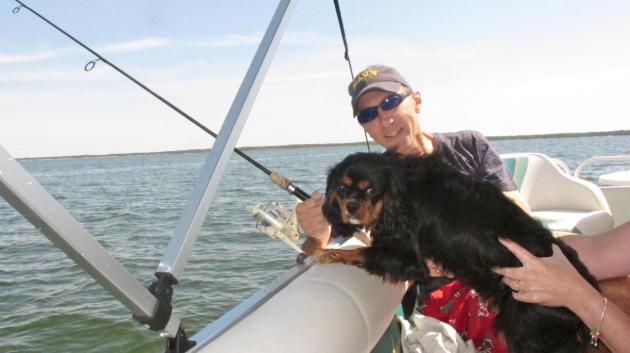
"Leo". That's our 1 year old spaniel, Leo, who loves walleye fishing off a pontoon. He catches more fish than I do.
Paul's Conservation Minnesota Outlook for the Twin Cities and all of Minnesota:
TODAY: Hot and sticky with a mix of clouds and sun. Winds: SW 10+ High: 91
TUESDAY NIGHT: Showers and T-storms likely, locally heavy rain possible late. Low: 65
WEDNESDAY: Wet start, then clearing, breezy and less humid. Dew point: 53. High: 76
THURSDAY: Some sun, more comfortable. Low: 56. High: 74
FRIDAY: Quick shower, feels like September. Low: 54. High: near 70
SATURDAY: Sunny, pleasant. Dew point: 44. Low: 52. High: 71
SUNDAY: Warm sun, just about perfect. Low: 53. High: 76
MONDAY: Summer rerun. Warming up with lot's of sun. Low: 57. High: 81
* temperatures warm well into the 80s the first half of next week, before a vigorous cold front arrives the end of next week.
Thinking Ahead
My State Fair food coma is wearing off. Hot and
dusty - it summed up the (real) summer we've had. Although more 80s, and
even a 90-degree day may return next week, it's probably human nature
to turn the page and ponder what comes next.
"Paul, for the first time in 35 years I couldn't
do any cross-country skiiing last winter" Dennis told me out at the
fair. "Tell me this winter will be better." El Nino, El Schmeeno -
statistical odds favor more than the paltry, Memphis-like 22 inches that
fell on the metro last winter. And yet I don't see anywhere close to
the 86 inches that buried MSP in 2010-2011.
This was the hottest summer since 1988. That
winter a whopping 70 inches fell at MSP, but there was no El Nino to
detour the jet stream. My gut feel (nausea?) 40-50 inches. Less than
average, but more than last winter. The atmosphere is warming, yes, but
we will still enjoy winter.
We approach 90F today before a southbound cool front sparks T-storms tonight. Within 24 hours we'll all be breathing easier.
A sunny, comfortable weekend gives way to a warming trend; 80s early next week.
Soak it up, because A REAL (jacket-worthy) cold front is brewing for late next week.
Climate Stories...
Climate Change This Week: Headlines from Huffington Post. Here's an excerpt of an article at
HuffPo:
Tipping, tipping ... And Thar She Goes! As Arctic summer ice likely disappears by 2022,
most Arctic experts say, after being taken aback by the swiftness of
this summer's record-breaking melt, reports Fen Montaigne at
Environment360. Most experts now agree that the polar summer ice is
beyond the point of return, and consequences will be profound,
including significant changes in weather patterns for the U.S. and
other countries in the northern hemisphere. And you thought 2012 was
interesting....
Global Warming Is Real! says an organization of American weather broadcasters,
the American Meteorological Society, reports Joe Romm at
ClimateProgress. Important, since most Americans rely on and trust
their weather broadcasters on weather and climate -- and most Americans
want to learn more about climate change from them.
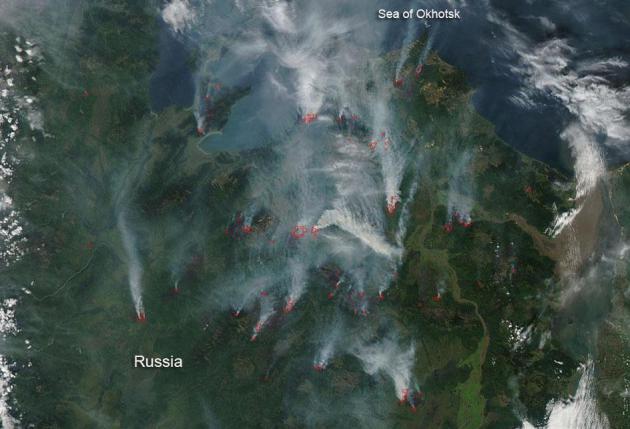
Hot Times in Siberia: Record wildfires in Siberian forests
and boglands have burned close to a half million acres during their
unusually hot summer, reports Brian Dunbar at the National Atmospheric
and Space Administration website. Hotter times for all of us, since the
wildfires' huge emissions of carbon dioxide further accelerates global
warming..."
* image of Siberian wildfires above courtesy of
NASA.
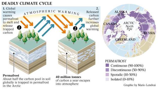
Siberian Thaw Unlocks Ice Age Carbon Vault. The
domino effect (positive feedback cycles) are now well underway. Who
cares that Siberian permafrost is melting, releasing methane, which is
21 times more potent than carbon dioxide?
The Australian explains why you should care; here's an excerpt: "
A
VAST outcrop of the Arctic Siberian coast that had been frozen for
tens of thousands of years is releasing huge carbon deposits as rising
temperatures thaw parts of its coastline, a study warned yesterday. The
carbon, a potential source of Earth-warming CO2, has lain frozen along
the 7000km northeast Siberian coastline since the last ice age. But
atmospheric warming and coastal erosion are gnawing at the icy seal,
releasing about 40 million tonnes of carbon a year - 10 times more than
previously thought, said a study in the journal Nature."
Illustration credit above: Mario Lendvai, The Australian.
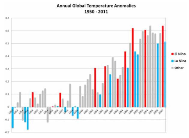
NOAA Says "50% Chance" El Nino Will Develop In Second Half of 2012; Which NASA Says Would Lead to "Rapid Warming". Wait,
haven't we already experienced "rapid warming"? 2012 is the warmest
year ever recorded, to date. The last 12 month average the warmest ever
recorded. Let's not even rehash July's records. Here's an excerpt of a
story at
Think Progress: "
NOAA’s Climate Prediction Center issued an “El Niño Watch“ today.
This chart from NOAA makes clear why that is a big deal: An El Niño in
the second half of 2012 would make it quite likely that 2013 would be
the hottest year on record. NASA had a long discussion of this very
point in a January analysis, “Global Temperature in 2011, Trends, and Prospects.” NASA explains that the apparent recent slowdown in global surface temperature rise is likely to prove “illusory”:
The cool La Niña phase of the cyclically variable Southern
Oscillation of tropical temperatures has been dominant in the past
three years, and the deepest solar minimum in the period of satellite
data occurred over the past half dozen years. We conclude that the slowdown of warming is likely to prove illusory, with more rapid warming appearing over the next few years."
Graph credit above: "Global average surface temperatures during El Niño and La Niña years."
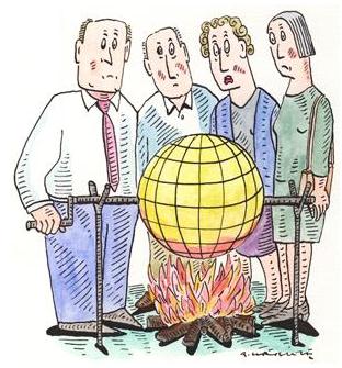
If 2013 Breaks Heat Record How Will Deniers Respond? Here's an excerpt of an interesting article at
newscientist.com: "
With an El Niño on the way, 2013 could be the warmest year on record. But the climate-denial machine will keep on churning.
IT HAS been another "normal" global-warming summer in the northern hemisphere. The US sweltered in the hottest July on record, following the hottest spring on record.
More than 60 per cent of the contiguous US is suffering from drought,
as are parts of eastern Europe and India. In the Arctic, sea ice cover
is at a record low and the Greenland ice sheet shows what the US National Snow and Ice Data Center calls "extraordinary high melting". Global land temperatures for May and June were the hottest since records began in the 19th century. Meanwhile, El Niño conditions are forecast to develop in the tropical Pacific Ocean,
warming up ocean surface temperatures. Some observers have predicted
that this will lead to record-breaking global temperatures next year. If
El Niño does arrive and temperature records are broken, there will
inevitably be much discussion of the causes of the warming. So now is a
good time to sort signal from noise in the global temperature records."
Illustration credit above: Andrzej Krauze.
 Democratic Party Platform Engages Climate Change
.
I'm still waiting to see if the Republican platform makes any attempt
to quantify climate change as an issue, or if it ultimately gets swept
under the rug. Here's an overview of the Democratic position on climate
change from
getenergysmart.com: "
In contrast to its total absence from the Republican Party platform
(as a sign of the GOP’s anti-science global warming denial), the Democratic Party platform directly engages on climate change issues — with the term appearing 18 times in the platform.
Not surprisingly, the environment section has direct discussion of climate change issues.
We know that global climate change is one of the biggest
threats of this generation – an economic, environmental, and national
security catastrophe in the making. We affirm the science of climate
change, commit to significantly reducing the pollution that causes
climate change, and know we have to meet this challenge by driving smart
policies that lead to greater growth in clean energy generation and
result in a range of economic and social benefits."


No comments:
Post a Comment