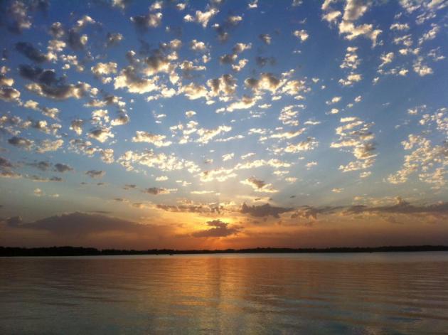
68 F. high in the Twin Cities Tuesday.
68 F. average high for September 25.
67 F. high on September 25, 2011.
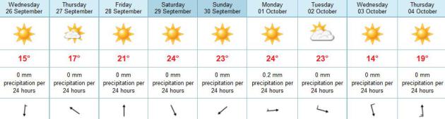
No rain predicted thru Sunday.
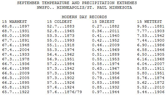
Driest September since 1882.
107 days above 70 F. in Duluth in 2012, a new
record. Monday's high of 73 F. broke the old record of 106 days above
70, set in 1955. Source: Duluth News Tribune. Average number of days
above 70 for KDLH? 85. Image: Wikipedia.
$1 billion. The amount of money that reportedly
changed hands (legal gambling) as a result of Monday night's blown call
against the Green Bay Packers. Source: ESPN. Photo credit:
wrapupp.com.
Driest September Since 1882. We've picked up a
paltry .30" rain so far this month, nearly 2.5" less than average, to
date. Only 1882 was drier (.27" for the month). So unless something
changes between now and Sunday this should wind up being the second
driest September in modern day records. Source:
Minnesota Climate Office.
Supernaturally Dry. Second driest September on
record for the Twin Cities and much of Minnesota, and it looks like
October will at least get off to a dry start. 60s today and Thursday,
then back into the 70s from Friday into next Tuesday, the ECMWF model
hinting at a stray shower Monday from a passing clipper (better chance
of showers over Wisconsin).
Drier Than Normal. The 84-hour NAM model prints out a
narrow band of showers across the Ohio River Valley into Pennsylvania,
spreading into southern New England by Thursday morning. Scattered
T-showers pop up frm Florida into Texas by the end of the week, while
the west stays dry and hot.
"...
Climate change is accelerating. The atmospheric
concentration of carbon dioxide (CO2) has risen by 31% since 1750 and
is now at the highest concentration seen in the last 420,000 years..." - from a Huffington Post story below.
"...The future points to intense, less frequent
precipitation; and wetter winters and springs, along with drier
summers, Jarchow said. “We are seeing more events like 3 inches (of
precipitation) followed by long periods of no rain, compared to
spread-out rainfalls. That requires much adjustment,” she said..." - from a story at The Yankton Press & Dakotan; details and links below.
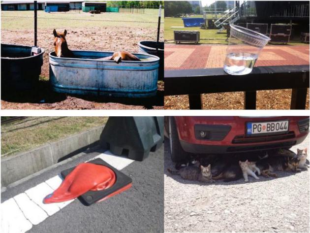
How Hot Was It? (part 2). If a picture tells a
thousands words, then I've just run out of reasons to keep typing. Here
is a collection of photos that sum up the relentless, at times
unbearable heat of the Summer of 2012. Thanks to Gary Botzek from
capitolconnections.com.
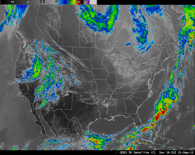
NOAA's Main Weather Satellite Goes Offline Amidst Hurricane Season.
GOES-13 began vibrating and then went dead. Another geosynchronous
weather satellite is being positioned to take its place - forecasters
hoping there are no big hurricanes in the Atlantic in the interim.
Here's a good summary of where things stand from
Think Progress: "
In
the midst of the very active North Atlantic hurricane season, the
main weather satellite scientists use for keeping tabs on the weather
across eastern North America and the Atlantic Ocean has gone offline. [Climate Central]
A San Diego County brush fire that has already destroyed 20 homes and
damaged 10 others continued to threaten an additional 80 homes,
officials said. [Los Angeles Times]
Forty-seven Republicans in the U.S. House of Representatives are
pushing Speaker John Boehner to eliminate the wind production tax
credit, a tax break that has split Republicans and drawn criticism from
presidential hopeful Mitt Romney. [Reuters]"
Using Polar-Orbiting Satellite Data To Help Fill In The Gaps During A GOES-13 Outage. Yes, satellite data has been wonky in recent days; there's an explanation - here's an excerpt from the
CIMSS Satellite Blog from The University of Wisconsin: "
The GOES-13 (GOES-East) satellite suffered anomalies that forced it to be placed into standby mode late in the day (at 21:22 UTC) on 23 September 2012 (NOAA NESDIS notification message).
The GOES-15 (GOES-West) satellite was then placed into Full Disk scan
mode, supplying images to cover as much of the eastern US and adjacent
offshore waters as possible at 30-minute intervals. During the GOES-13
outage, satellite imagery viewed in AWIPS on the “CONUS” scale did not
display the complete full disk scan information from GOES-15, resulting
in large areas with no data over the southeastern and eastern US
(note: the full GOES-15 scan sector is available when viewed on the AWIPS “North America” scale, but the data resolution is degraded due to the very large satellite viewing angle)."
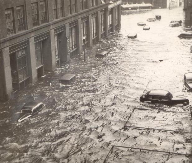
Weather Service Warns That 1938-Type Hurricane Could Someday Devastate Massachusetts.
Meteorologists are concerned about a growing sense of apathy, an "it
can't happen here" mentality, especially over coastal New England.
Here's an excerpt of an ominous article at
boston.com: "
If
a storm similar to the Great New England Hurricane of 1938 were to
strike again, communities in Buzzards Bay could be devastated, according
to a computerized model developed by the National Weather Service.
“It’s beautiful to live at the coast, that’s for sure, but one of these
days it’s going to get us,” said Glenn Field, warning coordination
meteorologist for the weather service in Taunton. The SLOSH, or Sea,
Lake, and Overland Surges from Hurricanes, model was used to simulate a
Category 3 hurricane traveling at 60 miles per hour, similar to the
1938 storm, moving through Narragansett Bay, just west of Buzzards Bay,
Field said."
Photo credit above: "
Could this happen again someday? The 1938 hurricane left the heart of Providence…" (Associated Press )
Concerns Grow As Tsunami Debris Continues To Arrive In U.S. The forecast calls for...debris? Here's an excerpt from
Stars and Stripes: "
HONOLULU
— Concern is growing about the potential effects on the environment
and on boating as more tsunami debris from Japan reaches Hawaii and the
western coast of Canada and the United States. Japanese officials
confirmed Friday that a container fished out of the ocean Wednesday
off Windward Oahu between the Makai Research Pier and Rabbit Island
was tsunami debris. The 4-foot-tall blue bin was spotted floating 150
yards offshore. It was encrusted with crabs and barnacles and
contained dead birds. In addition, officials continued to look Friday
for a floating concrete dock, about 50 by 30 feet, reported by Maui
fishermen and last seen Wednesday afternoon about 15 miles northwest
of Molokai."
Photo credit above: "
In this Sept. 19, 2012 file photo
provided by the Hawaii Department of Land and Natural Resources, a
worker removes barnacles and other marine life from the bottom of a
large blue plastic bin in Honolulu. There were no foreign plant or
animal species on the bin, the first confirmed piece of marine debris
from last year's tsunamis in Japan to arrive in Hawaii." (AP Photo/Department of Land and Natural Resources, Division of Aquatic Resources, File)
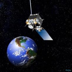
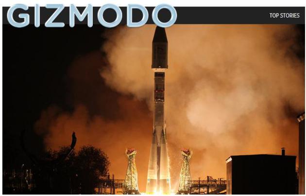
This School-Bus-Sized-Satellite Will Deliver Insanely Accurate Weather Reports.
The data may be insanely accurate - let's hope it leads to a noticeable
improvement in forecast accuracy. It's not always a direct line from A
to B. And any improvements will probably be limited to Europe, but
having better "eyes in the sky" benefits a global community of weather
consumers, no question. Here's an excerpt of a story at
Gizmodo.com: "
Europe
will receive nearly infallible weather data thanks to this trio of
school bus-sized spacecraft, and the EU saves £4.5 billion in
weather-related damage annually. This is what the atmosphere will look
like in HD. The satellite MetOp-B, which launched yesterday,
is part of a 3.2 billion Euro joint venture between the European Space
Agency and the European Organisation for the Exploitation of
Meteorological Satellites (EUMETSAT)."
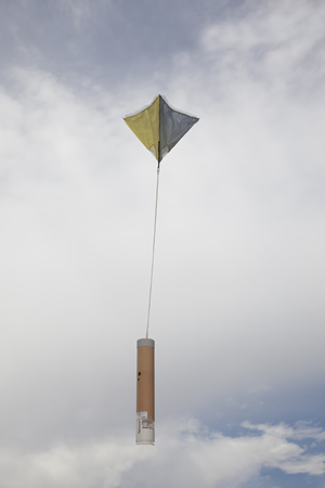
Dropsondes - Work Horses In Hurricane Forecasting. These little instruments that drop (via parachute) into hurricanes send back vital data to NHC forecasters. The
National Science Foundation (NSF) has a good article about how they work; here's an excerpt: "
Small
cylinders dropped from airplanes gather atmospheric data on their way
down. Inside a cylinder that is about the size of a roll of paper towels
lives a circuit board filled with sensors. It's called a dropsonde, or
"sonde" for short. It's a work horse of hurricane forecasting,
dropping out of "Hurricane Hunter" airplanes right into raging storms.
As the sonde falls through the air, its sensors gather data about the
atmosphere to help us better understand climate and other atmospheric
conditions. "Dropsondes have a huge impact on our understanding of
hurricanes and our ability to predict hurricanes," explains electrical
engineer Terry Hock at the Earth Observing Laboratory in the National
Center for Atmospheric Research (NCAR), located in Boulder, Colo." Photo:
NCAR.
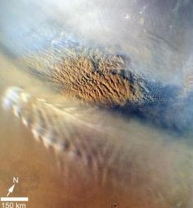
Curiosity's Weather Report From Mars Reveals "Truly Enormous" Daily Atmospheric Pressure Swings. Oh, to be a weatherguy on Mars. Here's a snippet from a fascinating story about weather extremes on the surface of Mars from
phys.org: "...
Over
the last 35 years, a total of four NASA probes had reached the Martian
surface and returned weather data. "These earlier observations had shown
a large daily cycle in temperature and air pressure on Mars. The
atmospheric temperature near the surface of Mars generally varies by
more than 100 F. between day and night because of the overall thinner
Martian atmosphere and lack of oceans and their moderating influence,"
says Hamilton."
Photo credit above: "
Image of a dust storm on Mars from NASA's Mars Reconnaissance Orbiter." Credit: Jet Propulsion Lab.
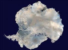
WeatherTalk: Russian Research Station In Antarctica Records Minus 129 F. Good grief. Remind me not to complain about -20 F. ever again. Details from Fargo/Moorhead's
inforum.com: "
Antarctica
is by far the coldest area on the planet. The coldest temperature
recorded on Earth was recorded at Vostok, the Russian Antarctica
research station in July 1983, when the temperature plunged to minus
129 degrees. That same station, just last week, recorded a low
temperature of minus 119 degrees on Sept. 16. That was very close to
the coldest temperature recorded on earth during the month of September
of minus 122 degrees at that very same site."
A Finger In The Wind: Forecasters Of Yesteryear. Yes, I have my bootleg copy of the
Farmers' Almanac
in my (locked) desk drawer - always fun and informative to see their
predictions for the upcoming season. Hey, I'm not ruling anything out -
and neither should you. The more data points the better. Here's an
excerpt of an article that provides some historical context with weather
forecasting thru the ages: "
From the beginning of time, weather and
the forecasting of it have affected the course of history.
Accordingly, the quest to understand, forecast, and adequately
communicate conditions in a timely manner has consumed civilization in
one form or another for hundreds and even thousands of years. Based on
Aristotle’s treatise on earth sciences Meteorologica, the name
“meteorology” has come to mean the science of the atmosphere and
weather. But long before the Greeks delved into the tenuous world of
weather observation and prognostication, ancient Babylonians—among the
earliest weather forecasters—had learned enough about the subject to
write “when a cloud grows dark in heaven, a wind will blow,” opening the
door to exploration and discovery."
"Ask Paul". Weather-related Q&A:
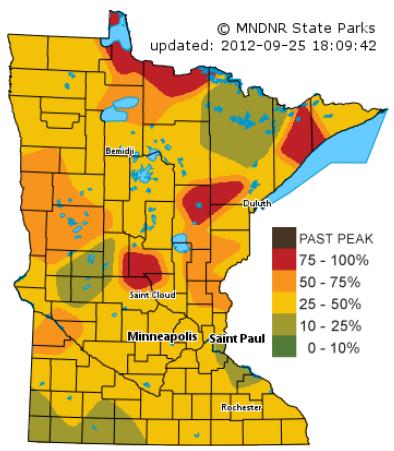
Paul -
Just took a look at the Fall Colors map on the DNR
site and it seems like they've actually bumped the Ft. Snelling
percentages back down to 25-50%. This essentially has removed all
portions of the metro from that 50-75% back down to the 25-50%. Not sure
why the 'downgrade' in percentage.
You can really see the 'spotchiness' on the map now as a handful of state parks are reporting 75-100% color.
Jon deJong
Weather Data Performance Manager @ Telvent
Jon - I see what you mean. Baffling. The latest Minnesota DNR
fall foliage map
is here. Colors are peaking north of St. Cloud and from Crosby to
Aitkin - more intense color along the North Shore of Lake Superior and
the International Falls area. Thanks for the note.
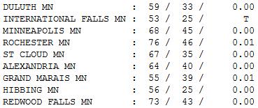
Another Perfect Day. Getting sick of this? Me
neither. Although a little rain would be nice to break the San
Diego-like monotony. Under a sunny sky with a few cirrus clouds
streaking overhead highs ranged from 53 at International Falls to 67 St.
Cloud, 68 Twin Cities to 73 at Redwood Falls.
Paul's Conservation Minnesota Outlook for the Twin Cities and all of Minnesota
TODAY: What else? Sunny, comfortable. Winds: N 10. High: 65
WEDNESDAY NIGHT: Clear and cool. Low: 44
THURSDAY: Blue sky, beautiful. High: 69
FRIDAY: Lot's of sun, a bit milder. Low: 48. High: 72
SATURDAY: We're in a drought. Still sunny - still dry. Low: 51. High: 75
SUNDAY: Yawn. Yep, still sunny. Light winds. Low: 53. High: 74
MONDAY: A few clouds? Wisconsin shower possible. Low: 54. High: 75
TUESDAY: One more time Paul: "sunny & mild". Low: 57. high: 78
Only 1882 Was Drier
Let's review state capitals and fantasy football
pics...and give thanks we didn't take a part-time NFL referee gig.
Ouch. There's no "weather" out there, and won't be looking out more than
a week.
This is why I plead with
atmospherically-challenged June brides to consider late September for
that "little outdoor wedding for 350 people". The odds are in your
favor.
The Force is with you.
Spring comes earlier (most years), and autumns
tend to be super-sized now; weather since 2000 consistently warm enough
for golf as late as November. If you need dry weather for an outdoor
bash, odds of quiet, dry, sunny weather are much higher in autumn than
spring or summer. Especially during a drought.
I'm enjoying a lukewarm blue sky just as much as
the next guy, but I agree with NOAA: our drought will, in all
probability, get worse in the months to come. I don't see a drop of rain
for most towns thru the end of next week.
Cool 60s today give way to 70s from Friday into Tuesday of next week.
Sketchy long-range model guidance is hinting at
some rain the first weekend of October. At .30 inches, this will be the
driest September since 1882; second driest on record.
Let it rain.
Climate Stories...
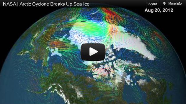
NASA: Arctic Cyclone Breaks Up Sea Ice. A series of major storms accelerated Arctic ice loss during August and September; more details in this excerpt from
Staple News: "
Watch
how the winds of a large Arctic cyclone broke up the thinning sea ice
cover of the Arctic Ocean in early August 2012. The storm likely
contributed to the ice cap's shrinking to the smallest recorded extent
in the past three decades. The frozen cap of the Arctic Ocean likely
reached its annual summertime minimum extent and broke a new record
low on Sept. 16, the National Snow and Ice Data Center (NSIDC) at the
University of Colorado in Boulder has reported. Analysis of satellite
data by NASA and the NASA-supported NSIDC showed that the sea ice
extent shrunk to 1.32 million square miles (3.41 million square
kilometers), or 293,000 square miles less than the previous lowest
extent in the satellite record, set in mid-September, 2007."
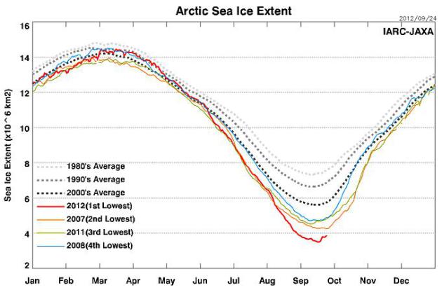
Ice-Free Arctic Is "Uncharted Territory." Here's an excerpt from
Common Dreams: "
UXBRIDGE, Canada -
The melt of Arctic sea ice has reached its lowest point this year,
shrinking 18 percent from last year’s near-record low. Summer ice this
year is half what it was 30 years ago and is now affecting weather
patterns. The massive declines in ice in recent summers have shocked
scientists and Arctic experts. Some predict that in just a few years we
will witness an event that hasn’t happened in millions of years: the
complete loss of summer ice. “We are now in uncharted territory,” said
Mark Serreze, director of the National Snow and Ice Data Center (NSIDC)
in Colorado."
Graph above courtesy of
JAXA: Japan Aerospace Exploration Agency, Earth Observation Research Center.
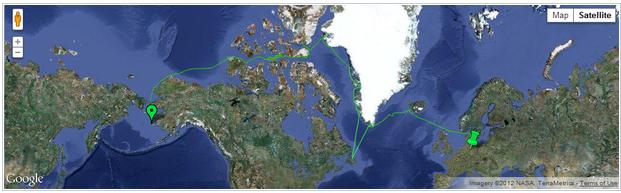
Climate Change Adventure: The Arctic's Melting, So These Guys Sailed Across It. Amazing.
The Atlantic has details of a cross-Arctic voyage that would not have been physically possible 10 years ago; here's an excerpt: "...
For
centuries European explorers searched for a passage unsuccessfully,
until 1906 when an expedition led by Norwegian explorer Roald Amundsen
made it across. Since then, better boat and navigation technology have
enabled more regular crossings, but the most northern routes have
remained off-limits for all but the strongest, diesel-powered,
extra-fortified, ice-breaking boats. Until this year, when three men
made the complete Northwest crossing through the M'Clure strait (the
northernmost of the direct routes) in the Belzebub II -- a sailboat
with no fortification. Previously, the only boats that had made it
through M'Clure were ice-breakers, and none had been able to complete
the pass through Viscount Melville Sound after shooting through
M'Clure. Usually only either the sound or the straight are open to
boats, but not both at once..."
How To Relate Climate Extremes To Climate Change. Is there a connection? Here's a clip from a story at
theenergycollective.com:
Trenberth: "
The answer to the oft-asked question of whether an
event is caused by climate change is that it is the wrong question. All
weather events are affected by climate change because the environment
in which they occur is warmer and moister than it used to be….
The air is on average warmer and moister than it was prior to
about 1970 and in turn has likely led to a 5–10 % effect on
precipitation and storms that is greatly amplified in extremes. The
warm moist air is readily advected onto land and caught up in weather
systems as part of the hydrological cycle, where it contributes to more
intense precipitation events that are widely observed to be occurring."
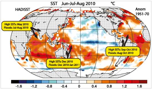
Graphic credit above: "
Seasonal Jun-Jul-Aug 2010 sea
surface temperature (SST) anomalies relative to 1951–70. Record high
SSTs were recorded in the locations and at the times indicated with
record flooding nearby."
Undecided Voters Care About Global Warming, Report Finds. Here's an excerpt from
Live Science: "
Only
about 7 percent of likely voters have not yet decided whether they
will support Barack Obama or Mitt Romney in the 2012 election, a new national
survey finds. But on the topic of climate change, at least, these
undecideds look more like Obama supporters than Romney voters. Undecided
voters are more likely than Romney voters to see climate change as an
important issue, and their desire for government action approaches
levels seen in Obama voters. What's more, undecideds are as likely as
Obama supporters to believe that global warming is happening and that humans are causing it."
U.S. Needs Climate Change Plan, Carbon Tax, Says Sachs. Here's a clip from an article at
bloomberg.com: "
The
U.S. needs a policy to address climate change and a plan to reduce
emissions that may include a carbon tax and bonds, Columbia University
Professor Jeffrey Sachs
said. “We have to make a technological transition that’s quite deep to
new energy systems, new transport systems, more efficient buildings and
that can be back loaded,” Sachs said to reporters today at Climate Week
NYC in New York. The public needs a plan that isn’t just about
electricity prices rising, said Sachs. “You can’t tell the public that
our plan is cap-and-trade,” he said. “That’s not a plan, that’s
frightening, that just means: our electricity prices are going up.”
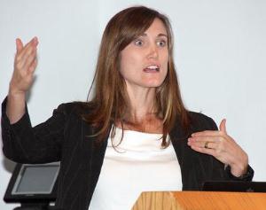
USD Panel: "Climate Change Will Change Us." Here's another article that caught my eye, an excerpt of a story from
The Yankton Press & Dakotan: "
VERMILLION
— At Monday’s forum, University of South Dakota panelists found global
warming to be a very hot topic. “Global Warming: The Evidence Is In!”
covered the scientific data pointing to global warming. But the
panelists also acknowledged the political, social, economic and
religious issues. Climate change will directly affect agriculture and
the way an exploding world population is fed, according to Dr. Meghann
Jarchow, assistant professor of Sustainability in the Department of
Biology. The future points to intense, less frequent precipitation; and
wetter winters and springs, along with drier summers, Jarchow said."
Photo credit above: "
Dr. Meghann Jarchow, assistant
professor of Sustainability, speaks about the challenges facing
agriculture because of climate change during Monday’s international
forum at the University of South Dakota in Vermillion." (Kelly Hertz/P&D)
"The Climate Clock Is Ticking". Bianca Jagger (yes, that Jagger) has a story at
Huffington Post
that caught my eye Tuesday; here's an excerpt: "...If you had told me
twenty years ago that by 2012 global carbon emissions would have
increased by around 50%, that 1 billion people in the world would be
hungry, that fossil fuel subsidies would amount to $1 trillion a year, I
would have been horrified. The science cannot be ignored. Climate
change is accelerating. The atmospheric concentration of carbon dioxide
(CO2) has risen by 31% since 1750 and is now at the
highest concentration seen in the last 420,000 years.
August 2012 was the fourth warmest such month on record worldwide.
July 2012 was the hottest month on record for the continental US. In June 2012 monitoring stations in the Arctic showed the
highest ever recorded concentrations
of carbon dioxide, of over 400 ppm (parts per million). The rest of
the world will soon follow suit. Between the 8th and the 12th of July
2012 the
melted ice area
in Greenland increased from the usual 40% to 97%: a 57% increase over
the course of just four days. On 4 September, sea ice extent fell below
four million sq km,
a record low in the 33-year satellite record...
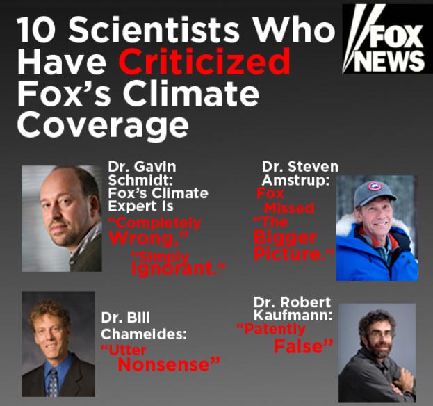
"Utter Nonsense." 10 Scientists Who Have Criticized Fox's Climate Coverage.
Media Matters has the story; here's the introduction: "
An analysis by the Union of Concerned Scientists found
that 93 percent of Fox News' recent climate change coverage was
misleading. Over the last two years, several leading scientists have
told Media Matters the same thing, calling Fox's climate change stories
"completely wrong," "patently false," and "utter nonsense." Here are
ten scientists who have criticized Fox for distorting science to
downplay the threat of climate change:
1. Scientist Called Fox's Global Warming Claims "Utter Nonsense."
Last summer, Fox News hosted global warming "expert" Joe Bastardi to
claim that the human-induced climate change contradicts the 1st law of
thermodynamics and Le Chatelier's Principle. Duke University scientist
William Chameides called Bastardi's
claims "utter nonsense," and the University of Chicago's David Archer
said Fox is "wrong" to suggest that these basic principles negate the
risks of climate change. Richard Muller, a physics professor at the
University of California, Berkeley, agreed that Bastardi's claims are
"completely wrong," adding that "even skeptics of global warming, if
they know physics, would disagree with him." Even Judith Curry, a
climatologist at the Georgia Institute of Technology and a frequent
critic of the IPCC, said that
Bastardi's statements imply that "he does not understand the very
basics of the science." She added, "Fox News needs to find a more
credible spokesperson."
*
here is a long list
of Bastardi's factual errors and persistent confusion about how science
and physics really works. CO2 can't cause warming? In short, he is
using hand-waving arguments and blog posts to try and invalidate 200
years of scientific discovery. Joe Bastardi is a gifted meteorologist
and weather forecaster but on the subject of climate science? Not so
much.


No comments:
Post a Comment