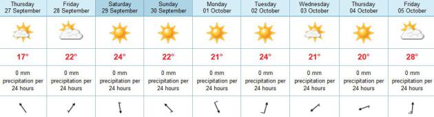
65 F. high in the Twin Cities on Wednesday.
67 F. average high for September 26.
70 F. high on September 26, 2011.
No significant rain thru at least Friday of next week.
Ah, The Memories: data courtesy of The Minnesota Climatology Working Group:
October 9, 2011: last 80-degree high last year (83 F. in the Twin Cities).
October 11, 2011: last 70-degree high in the metro (76 F).
November 12, 2011: last 60-degree high at KMSP (64 F.)
November 9, 2011. Date of the first trace of snow flurries in the Twin Cities last autumn.
November 19, 2011. 3" of snow fell at KMSP, the first "plowable snowfall" last winter season.
Ditto. We warm up in the coming days: 70s likely
from Friday into much of next week, in fact the ECMWF model is hinting
at highs near 80 by Friday of next week. Yes, it's premature packing
away the shorts. Not a drop of rain in the extended outlook.
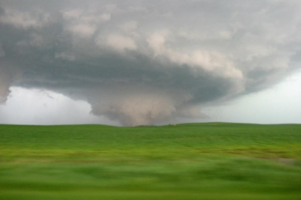
724 tornadoes reported, nationwide, as of September 25.
1,692 tornadoes in 2011 across the USA. Source:
NOAA SPC.
“
This is what global warming looks like at the regional or
personal level,” said University of Arizona scientist Jonathan
Overpeck, speaking to the Associated Press recently. “The extra heat
increases the odds of worse heat waves, droughts, storms and
wildfire. This is certainly what I and many other climate scientists have been warning about.” - from a post at Think Progress; details below.
"...
How did denial of science become a partisan issue? One
possible explanation comes from a field of psychology known as cultural
cognition. The basic idea is that our personal values color our
perception of everything, even science. If a scientific finding
contradicts deeply held values, we tend to discount it..." - from a WGBH News report, full details and links below.
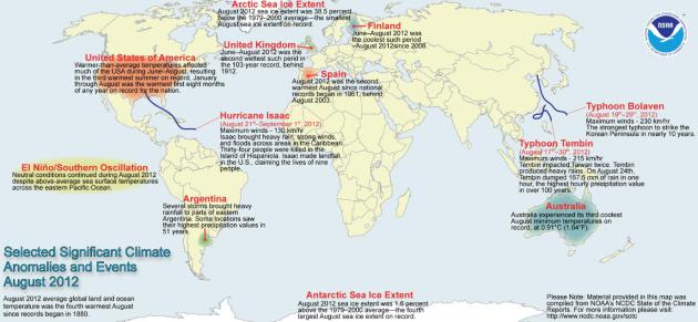
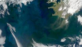
4th Warmest August, Worldwide, Since 1880. Global temperatures were 1.12 F. warmer than the 20th centery August average temperature of 60.1 F. Source:
NOAA. A larger version of the map highlights above is
here.
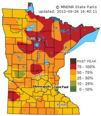
Colors Peaking Up North. My hunch: this may be the
best weekend to load up the kids into the SUV or minivan and head north,
colors close to peak from Leech Lake to International Falls and Lake
Superior's North Shore. Patches of vibrant color can also be found near
Little Falls and Wadena. Source: Minnesota
DNR.
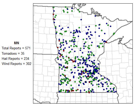
No Metro Tornadoes In 2012. Well, the stinking hot
summer did have a few benefits: less quality time huddled in the
basement with tornadic storms raging overhead. According to
SPC:
35 (mostly small) tornadoes statewide, none in the immediate metro
area. That's highly unusual, a rare silver lining to the sustained heat
and drought.
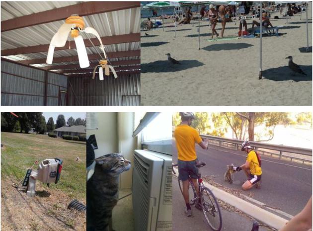
How Hot Was It? (part 3). This is the last batch of
sizzling summer photos, courtesy of Gary Botzek at
capitolconnections.com. Yep, that pretty much sums it up. I've
discovered that cats love A/C as much as we do, and on a blazing day a
koala will accept a cool drink from a complete stranger. That had to be
in Australia, right?
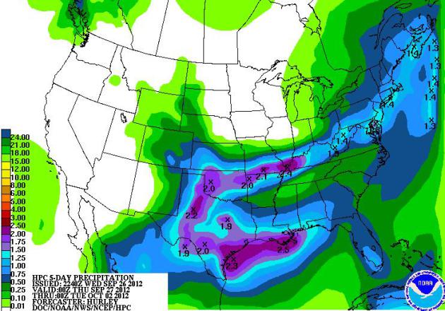
5-Day Rainfall. NOAA HPC is predicting 1-3" rains
from Texas into the Ohio River Valley along a stalled frontal boundary -
no rain of significance from the Upper Midwest into most of the western
USA.
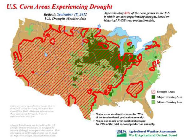
85% of America's Corn-Growing Regions Experiencing Drought. Here's an excerpt of a drought summary from USDA and
NOAA: "
USDA’s
World Agriculture Outlook Board, as of September 18, estimates that 85%
of the corn grown in the U.S. is experiencing drought. Similarly, 82%
of soybeans, 67% of hay, and 75% of cattle are experiencing drought.
This has resulted in a reduction in corn and soybean production since
July. The U.S. Drought Impact Reporter also keeps track of U.S. drought
impacts."
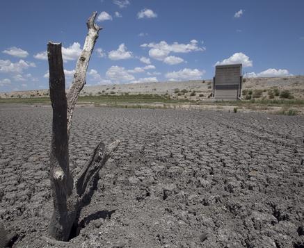
Texas Drought Killed 300 Million Trees Last Year. USA Today has the details
here. Photo credit: "
A dead tree rises out of a dried-up lake bed in San Angelo, Texas, in August 2011." Tony Gutierrez, AP.
Scientists Seek Insights Into Drought Outlier Projects.
Will we ever get better at predicting drought and major heat waves,
months in advance? Here's another very timely article from
Climate Central,
focused on drought. The more I look at the maps (over the span of
decades) the more I see a trend toward more drought, covering more of
the USA. It almost seems like we're in a perpetual drought, punctuated
by a few wet periods during the late spring and early summer months.
But so much of 2012, like many recent years, has brought a dry bias.
Here's an excerpt: "
Although official drought outlooks failed to provide Americans with advanced notice
of one of the worst droughts to strike the U.S. since the Dust
Bowl-era — a drought that is still ongoing — there were some computer
models that got the forecast right. Viewed as outliers at the time by
climate forecasters tasked with making seasonal forecasts, such models
look downright prescient with hindsight. In the wake of the flawed
forecasts, climate researchers are seeking to understand what enabled
certain computer models to anticipate the drought and intense heat that
affected much of the U.S. beginning in March, in order to recognize
the early warning signs the next time around. Their task is a complex
one, since models show varying levels of skill depending on the initial
climate conditions and time of year when a forecast is made."
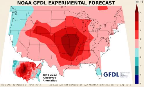
Graphic credit above: "
The
GFDL's experimental climate forecast for temperatures during June that
was initialized on March 1. Actual June temperature anomalies are
shown in the bottom left of the image." Credit: Gabe Vecchi/GFDL.
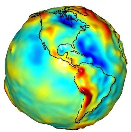
Gravity Probe Shows Groundwater Reserves Slipping Away. Gizmag.com
has an interesting article about the new generation of NASA's "Grace"
satellites that can detect ground water supplies, worldwide. Here's an
excerpt: "Recently, drought seems to be a fact of life. As
the lead photograph poignantly illustrates, most of the U.S. has been
struggling with serious levels of drought for the past several years.
Worldwide, drought affected areas include Europe, India and Pakistan,
Russia, much of Africa, South America – the list goes on. But when the
rains start again, everyone expresses great relief, not realizing that
long-term depletion of groundwater reserves is part of the price for
surviving drought. It was with this in mind that GRACE (Gravity
Recovery and Climate Experiment), a joint U.S. and German space
project, was designed a decade ago."
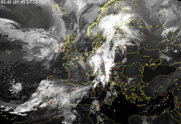
Storm Caused By Most Intense Low To Cross U.K. In 30 Years.
The U.K. Met Office has details on an unusually intense storm to strike the British Isles; here's an excerpt: "
The
low pressure system that has brought heavy rain, strong winds and
flooding to the UK is the most intense to cross the UK for more than 30
years, with the lowest air pressure of 973mb being recorded on Tuesday
morning. To find a similarly intense low pressure system that affected a
wide part of the UK in September you need to go back to 1981, when
pressures below 970mb were reported across central parts of the UK."
IR satellite image above:
sat24.com.
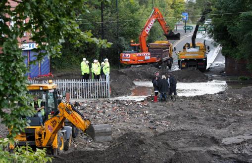
Heavy Rain Causes Flooding Across The U.K.
The BBC has more details (and video): "
Homes
have been evacuated and train services disrupted, as heavy downpours
continue across parts of the UK. In England, the Environment Agency has
issued 78 flood warnings - indicating flooding is expected - for the
Midlands, the North East and North West. There is one in place for
Wales. In Scotland, there are eight flood warnings, mostly for the
Borders, while in Northern Ireland there is no flood warning system but
the Met Office has warned of persistent rain and gales."
Photo credit above: "
Worker's are surrounded by debris
washed from a block of apartments which have had there foundations
washed away by the heavy flood waters in Newburn, near Newcastle,
England, Wednesday, Sept. 26, 2012 as communities work to rescue
stranded residents from their homes, after heavy rain caused flash
floods across parts of Britain. People have been evacuated from their
homes and flooding has caused major disruption to transport after parts
of the United Kingdom were battered with more heavy rain." (AP Photo/Scott Heppell)
Poll: Hunter, Angler Concerns Include Global Warming. Dennis Anderson has an interesting story in
The Star Tribune; here's an excerpt: "
Forty-two
percent of hunters and anglers who consider themselves Republicans,
and an even greater percentage who say they are ideologically
conservative, agree with hunters and anglers of more independent and
liberal persuasions that global warming is occurring and that the
nation’s natural resources should be protected for future generations.
These and other findings of a nationwide poll conducted for the
National Wildlife Federation (NWF) were released Tuesday in an effort to
inject conservation into discussions leading up to November’s local,
state and national elections. “Hunters and anglers have a strong desire
to pass on this incredible (outdoor) legacy,’’ NWF supporter Theodore
Roosevelt IV said in a conference call with reporters. “We want to
encourage sportsmen to raise their hands and ask questions (of
candidates) this fall.’’ A high percentage of hunters and anglers vote,
the poll found, and while gun rights are important to them, natural
resource conservation is also important..."
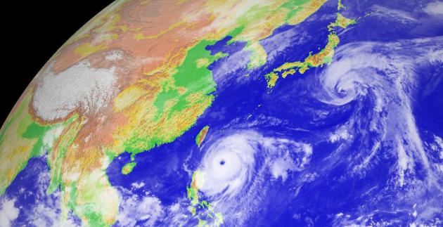
Super Typhoon Jelewat Headed Towards Okinawa. Dr. Jeff Masters has the latest in his
Wunderblog; here's an excerpt: "
Super Typhoon Jelawat
completed an eyewall replacement cycle over the past 24 hours,
resulting in a slight weakening of the storm below Category 5 strength.
Jelawat is now a Category 4 super typhoon with 155 mph winds.
Fortunately, Jelawat is located well east of the Philippine Islands, and
the storm is not expected to hit land while it is at major typhoon
strength. Wind shear
remains a light 5 - 10 knots over Jelawat, and the typhoon is over
very warm ocean waters of 29°C that extend to great depth, so it is
possible that Jelawat could regain Category 5 status later today. Satellite loops
show an impressive, well-organized typhoon with a 25 mile-wide eye,
and a large, symmetric area of heavy thunderstorms with cold cloud tops."
* image above courtesy of Digital Typhoon.
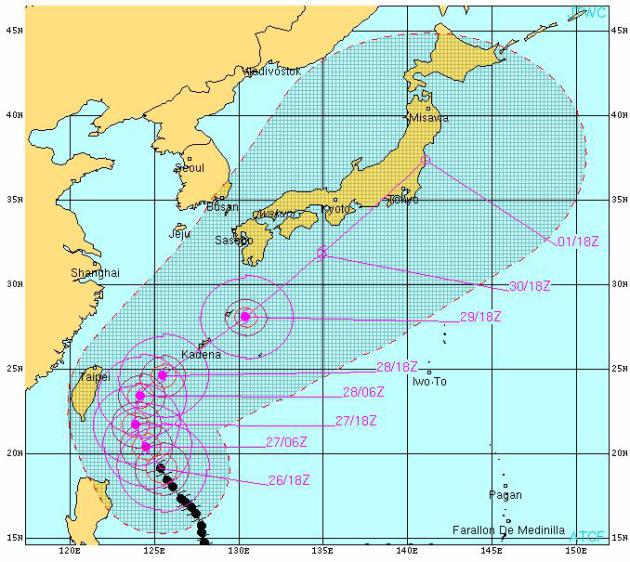
Typhoon Track. Typhoon Jelawat is forecast to score a
direct strike on the island of Okinawa, probably weakening to tropical
storm force before brushing Japan in the days ahead. Track map above
courtesy of the
U.S. Navy.
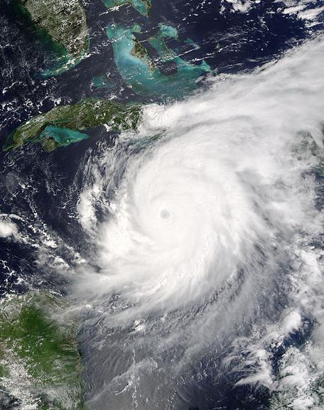
Hurricane History: Fewer Storms In October. We're
past the historic peak of the hurricane cycle (September 10) but we're
not quite out of the woods just yet. Here's a clip of a story from
WDSU-TV and
The Sun Herald: "
We've
passed the peak of hurricane season with 14 storms, eight hurricanes
and one intense hurricane. October is fast upon us, a time we may
actually see a secondary spike in tropical activity in the middle of
the month. Even though cold fronts are beginning to move into the Gulf,
water temperatures are still in the upper 80s in the south central
Gulf, and low to mid-80s just offshore. Water temperatures just need to
be 80 degrees for tropical development. Thunderstorms along those
early-season cold fronts that stall in the Gulf of Mexico can linger
and develop into depressions, storms or hurricanes. We also still watch
waves moving off the coast of Africa, though most development this
time of the year is closer to the southeastern United States, the
Caribbean or in the Gulf." Hurricane Ivan file photo courtesy of NASA.
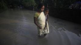
Nearly 2 Million Displace After India Floods. Details from
The Voice of America; here's a clip: "
Flooding
has killed at least 18 people and displaced nearly two million others
in India's northeastern Assam state. Military and disaster relief teams
have launched rescue and relief operations delivering food and medicine
and moving others to higher ground. The state's disaster management
officials say hundreds of relief camps have been set up across the to
assist flood victims. Sixteen of the Assam's 27 districts have been
affected by the floods, but rising levels in the Brahmaputra River
threaten some of the state's lower-lying areas."
Photo credit above: "
A flood
affected woman with her child wades through a flooded road in
Chandrapur village, outskirts of Gauhati, Assam state, India, Sept. 25,
2012."
Read more here: http://www.sunherald.com/2012/09/25/4208582/hurricane-history-fewer-storms.html#storylink=cpy
BMW Crowdsourcing The Future Of Urban Driving Technology. This makes sense, pulling on social media and crowdsourcing to come up with the most viable, popular solutions.
Gizmag.com explains: "
One
of the most established luxury auto marques is teaming up with one of
the market's latest, buzziest firms to visualize the future of design
and technology. BMW is working with crowd-source guru Local Motors in a
new contest designed to gain a broader perspective on the future of
sustainable urban mobility."
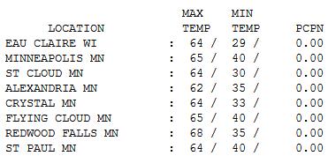
Another Flawless Day. Setting aside the growing
drought - yes, it was another phenomenal day statewide, temperatures 1-5
F. cooler than average. Under a perfect-blue sky, highs ranged from 62
at Alexandria to 64 St. Cloud, 65 Twin Cities and 68 at Redwood Falls.
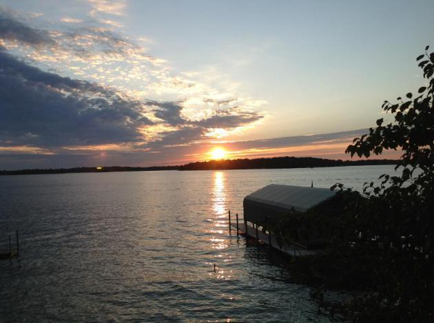
Just Ducky. WeatherNation TV meteorologist Addison
Green snapped these photos at Lake of the Isles Wednesday. A nice day
for a stroll indeed.
Paul's Conservation Minnesota Outlook for the Twin Cities and all of Minnesota:
TODAY: Lukewarm sun, beautiful. Winds: SE 3-8. High: near 70
THURSDAY NIGHT: Clear and cool. Low: 49
FRIDAY: Sunny and warmer. High: 77
SATURDAY: Blue sky - still unseasonably warm. Leaves peak up north. Low: 52. High: 79
SUNDAY: Monotonous sunshine. Still perfect. Low: 53. High: 77
MONDAY: Still dry, turning slightly cooler. Low: 55. High: 73
TUESDAY: Breezy and warmer with a mix of clouds and sun. Low: 53. High: 79
WEDNESDAY: Some sun, showers far northern Minnesota. Low: 51. High: 72
A Dry-Silver Lining
Were you paying attention? Fewer favorite TV
shows interrupted by breathless meteorologists tracking wobbly red blobs
on Doppler this summer? No tornadoes in the metro; most of the 35
twisters over western and southwestern Minnesota were small. Yes, it's
hard getting tornadoes when it's sunny and 97.
Rabid heat pushed the main storm track into Canada; Saskatchewan saw more touchdowns than the USA during July.
So lake water levels are down, the fire risk is
high, and my lawn looks like something out of the bottom of an Easter
Egg basket, but at least I didn't have to flee to my basement.
Nationwide: 724 tornadoes so far in 2012. That compares to 1,692 last year. Weather-whiplash.
I honestly can't remember the last time we
enjoyed a soaking, all-day rain - and the maps aren't very encouraging.
Northern Minnesota will see some rain next week, but the metro and
surrounding 'burbs may not see a drop of rain thru next Friday.
Remember Dustin Hoffman in "The Graduate"? Well forget plastics. Two words: "irrigation equipment".
The weather? The same. Blue sky; 70F today - 80 not out of the question Saturday, again next Tuesday.
I told you not to pack away the shorts just yet.
Climate Stories...
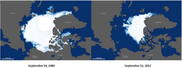
The Big Melt.
NASA's Earth Observatory
has a comparison of Arctic ice levels from September 1984 to September
2012. This made me stop in my tracks. Arctic ice is the Northern
Hemisphere's air conditioning system - the proverbial canary in the
coalmine.
Markey/Waxman Report: Carbon Pollution Creating "Cocktail of Heat and Extreme Weather". Think Progress has the details; here's an excerpt: "
Two House Democrats have released a report that aims to connect the dots on climate change and extreme weather events. The staff report,
issued by Henry Waxman (D-Calif.) and Edward Markey (D-Mass.),
outlines the past year’s record-setting temperatures, storms, droughts,
water levels and wildfires, and is being circulated in an attempt to
rebuild congressional momentum to address climate change. “The evidence
is overwhelming — climate change is occurring and it is occurring
now,” said Rep. Waxman, a Ranking Member of the Energy and Commerce
Committee, in a statement."
30 Issues: Behind The Partisan Divide On Climate Change.
Using established science as a litmus test for how conservative you
are? Climate science as a political football? It's all a bit surreal, as
WGBH News in Boston reports; here's an excerpt: "
It’s
been said so many times, it’s hard to even find an original source.
Everyone is entitled to his or her own opinion, but not her own facts.
When it comes to climate change, though, there seem to be two versions
of the facts – the Democratic and the Republican. Democrats largely
align themselves with the scientific consensus (and it is a remarkably
strong consensus; at least 97% of climate scientists are in agreement)
that climate change is happening and largely human-caused. In contrast,
climate change denial has become a litmus test for Republican
political candidates."
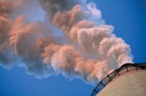
As The U.S. Warms, Power Plants Face New Water Limits. Meteorologist Andrew Freedman has the story at
Climate Central; here's an excerpt: "
The
study, conducted by a team of U.S. and European researchers and
published in Nature Climate Change in June, found that increasing water
temperatures and reduced river flows during the summer months
constitute the achilles heal of the power sector, making power plants
vulnerable to significant disruptions in service at the very times when
they are needed most. The study's findings were based on computer
modeling of how climate change will affect summer river flows and water
temperatures at 61 U.S. power plants and 35 plants in Europe. Previous
studies had only examined changes in river flows, overlooking the
cooling water issue." Photo: EPA.
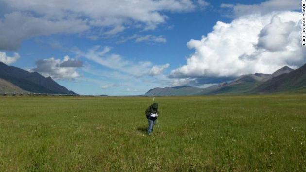
Next Global Warming Worry: Thawing Tundra. Here's a snippet of a story at
cnn.com: "...
And
in case you thought that what happens on the tundra stays on the
tundra, consider that many of the sparrows, robins and warblers that
visit our backyards in winter, or pass through come fall and spring,
spend their summers breeding on the tundra; so, whatever happens to
them there will affect which ones and how many of them show up at your
bird feeder in the future, potentially setting off a local domino
effect. Since the Arctic as a whole is responding to climate change
earlier and more acutely than the rest of the planet, we should think
of it as an early warning system -- a proverbial canary in a coalmine.
Perhaps if we pay closer attention to how the tundra is changing, we
can learn some practical lessons on what types of changes to expect
here at lower latitudes, which would enable us to mitigate the
consequences, or at least plan for how to cope with them."
Photo credit above: Ashley Asmus. "
Researcher Shannan
Sweet working in the Alaskan tundra in summer. Natalie Boelman says
thawing of the tundra could release vast amounts of carbon dioxide and
methane into the atmosphere."


No comments:
Post a Comment