79 F. high in the Twin Cities Saturday.
75 F. average high for September 8.
86 F. high on September 8, 2011.
36 mph. Peak wind gust at KMSP at 3:53 pm yesterday.
17 F. low temperature at Roseau, Minnesota on September 8, 1917.
92 F. predicted high for Tuesday, probably the 31st day this year of 90+ temperatures in the Twin Cities.
Fire Weather. The combination of 80s and 90s
(Tuesday) with gusty winds and low humidity will increase the potential
for wildfires early this week. The risk will peak on Tuesday. More from
the local office of the
National Weather Service.
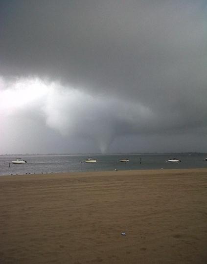
Money Shot.
Here is the waterspout that came ashore, sparking significant wind
damage in parts of Queens and Brooklyn, New York. Credit: Joey Mure and
Michael Abrams from 11 Bayside, Breezy Point, New York. Well done.
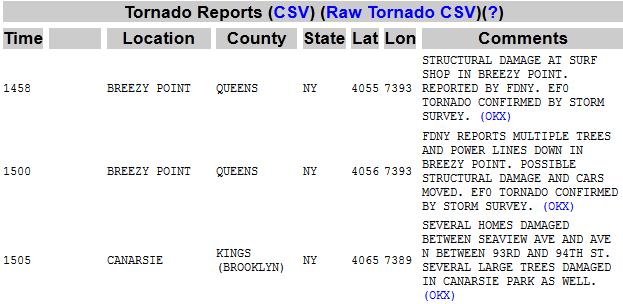
EF-0 Tornadoes reported at Breezy Point, Queens
(started as a waterspout over New York Harbor). Another touchdown in
Brooklyn. Data: SPC.
Tornadoes in New York City? Here's an excerpt from
Time Magazine: "
The
September weather system marks the second time in four months that
tornado-like circumstances have touched down in New York. From
1950-1974, the city experienced a dry spell, with no storms on record.
But since the mid 70s, seven tornadoes had touched ground, including
July 25, 2010′s EF1 system in the Bronx (86-110 mile-per hour winds)."
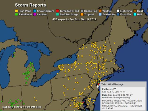
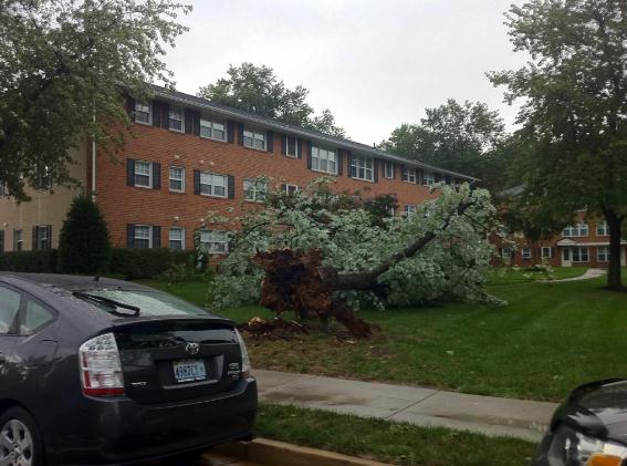
Saturday Storm Damage. There were scores of reports
of wind damage from New England southward to the D.C. area. SPC reports
at least 3 tornado touchdowns in metro New York, another north of
Annapolis, Maryland. An interactive storm damage map from Ham Weather
here.
Storm Damage. Lauren Crawford took this
photo
in Arlington, Virginia. High winds downed trees and knocked out power
to hundreds of thousands of residents in the Mid Atlantic Region.
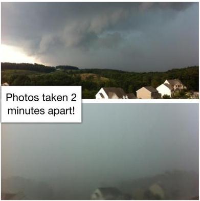
Instant Downpour. Thanks to meteorologist Justin Berk for passing on this photo sequence: "That
was the fastest I’ve seen it roll in and we get active weather here.
This is south central York County Pa. About 30-40 miles north of
Baltimore looking southwest."
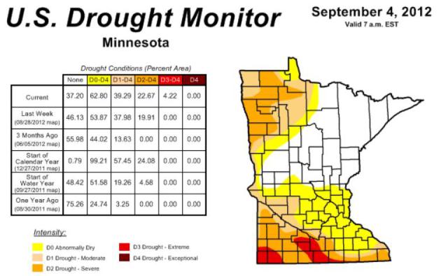
Drought Worsens Over Southern Minnesota. Here's more information from the
Minnesota Climatology Working Group: "
The U. S. Drought Monitor, released on September 6 places portions of southwestern and south central Minnesota in the Extreme Drought category (map at right).
Many northwestern Minnesota counties, and many of Minnesota's
southernmost counties are said to be in Severe Drought. In total,
approximately 63 percent of Minnesota is considered to be in the
Abnormally Dry category or worse.
Topsoil moisture across 63 percent of Minnesota's landscape is said to be Short or Very Short.
Stream flow measurements at reporting stations in the driest areas of the state rank below the 10th percentile when compared with historical data for the date.
The drought situation in northwest Minnesota is the result of an
historically dry autumn in 2011, a snow-sparse winter, and a dry 2012
growing season (maps below). The moisture deficits in southern Minnesota developed rapidly due to very hot and very dry conditions over the past eleven weeks (maps below).
Over this period, rainfall totals in many Minnesota counties fell
short of average by four or more inches. This is the climatological
equivalent of missing an entire summer's month worth of precipitation.
In some south central Minnesota communities, late-summer rainfall
deficits are in excess of six inches."
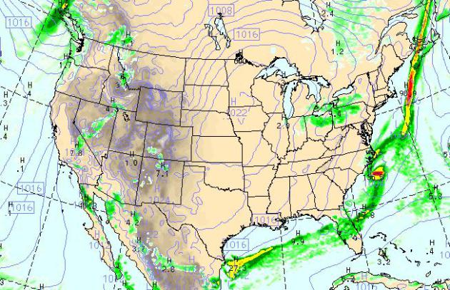
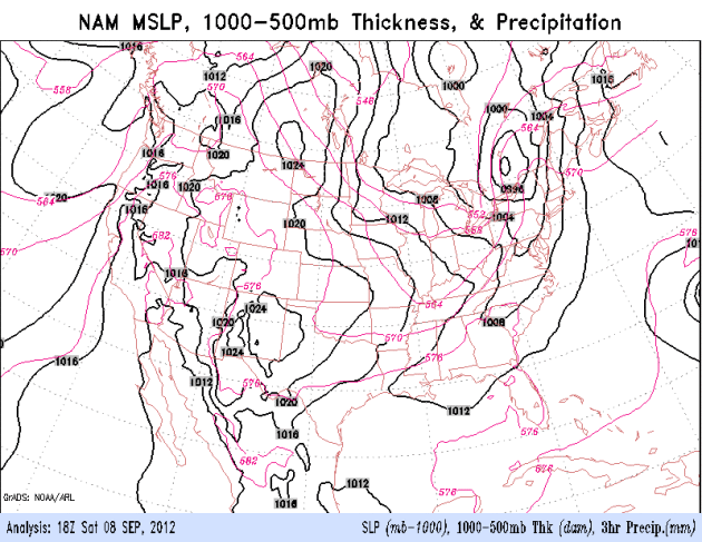
4 pm Today. The WRF model shows Saturday's squall
line of intense thunderstorms pushing out to sea, a sunny, quiet day
from Boston to New York and D.C. Lake effect showers pop up from Detroit
to Cleveland and Pittsburgh, while the southeast dries out, dry weather
the rule over most of the USA.
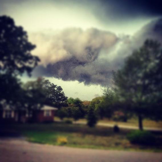
Stormy Magic. I love this effect: sharp focus at
screen center, blurring the edges. Thanks to Chris Whitney, who snapped
this photo in Arkansas. Photo via
Twitter.
Drier, With Fewer Sirens. The NAM model shows a
badly-needed clearing trend east of the Appalachians, T-storms pushing
across Florida, while cool high pressure of Canadian origin provides a
fresh breeze across the Great Lakes and Midwest.
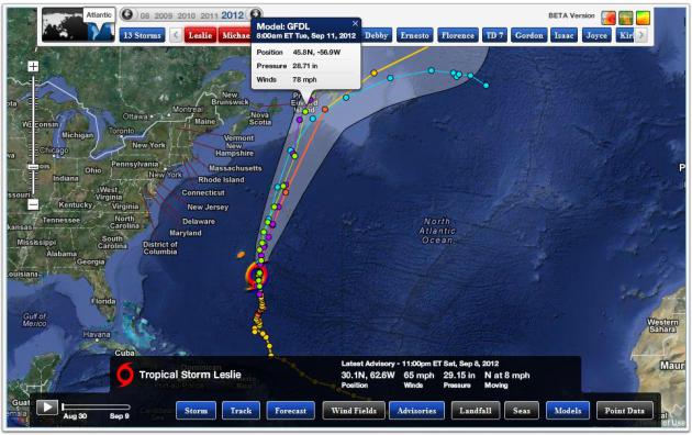
"Leslie". As of late last night Leslie was still a
tropical storm with 65 mph sustained winds. Models still show
strengthening to Category 1-2 status, reaching St. John's, Newfoundland
by Tuesday morning. Map: Ham Weather.
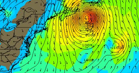
Landfall. The GFS model continues to intensify
Leslie into a significant hurricane; unusually warm ocean water in the
North Atlantic could mean hurricane landfall somewhere near
Newfoundland, Canada early next week.
Warming Trend, Then (A Little) Rain. The ECMWF model
is somewhat wetter and cooler than it was yesterday. After peaking near
90 Tuesday we cool off rapidly the latter half of next week, a little
rain from Wednesday into Friday - skies clearing in time for next
weekend. Right now Saturday looks like the warmer day, highs well up
into the 70s.
"
Here's what makes the general silence on climate and the mocking
from the self-identified pro-business party so absurd: tackling climate
change is the smartest thing we can do for both our public health and
our private sector. Reducing carbon emissions from our power plants,
cars, and factories cleans the air and saves a lot of money." - from an Op-Ed at Bloomberg, details below.
"...
The good news is that creating businesses that will power our
growth, and reduce our carbon output while protecting resources, is
also the greatest wealth-generating opportunity of our generation.
[There is no] choice between growth and reducing our carbon output." - Sir Richard Branson, quoted in a Bloomberg article below.
6 lowest Arctic sea ice levels on record all occurred in the past 6 years. Source: Wall Street Journal.
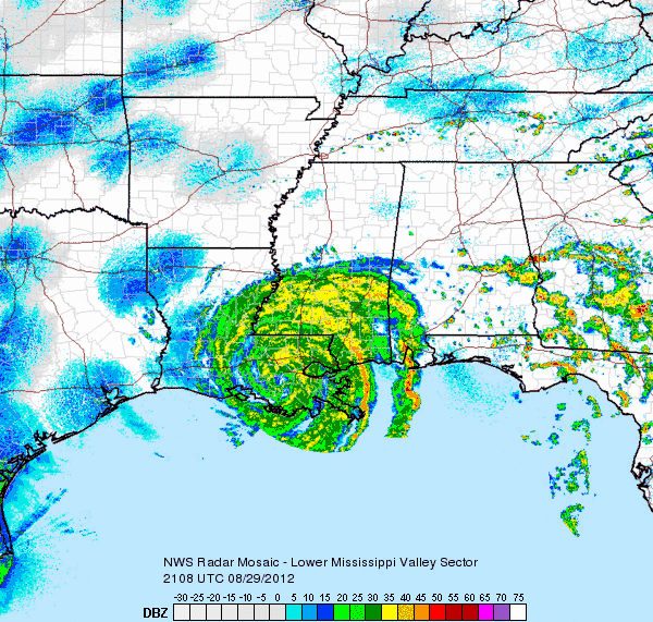
$3 billion in damage from Hurricane Isaac, with 40 deaths reported. Details below at earthsky.org.
13,000 homes damaged or destroyed by Isaac in Louisiana alone. Radar loop above: NOAA, earthsky.org.
Second wettest summer on record for the U.K. Only 1912 was wetter.
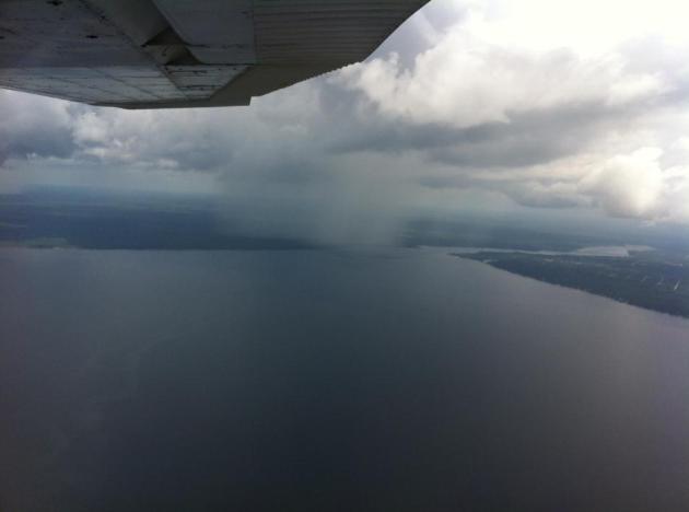 Definition Of An "Isolated Shower"
.
This photo was taken by Navy Ensign Brett Kruhoeffer 3,000 feet above
Pensacola Bay in a Cessna 172, a rain shaft 2 miles away the only shower
in the area.
Dryness Continuing Into September. Dr. Mark Seeley has more details on the expanding, deepending drought across Minnesota in this week's installment of
Minnesota WeatherTalk; here's an excerpt: "
Not
only was the 12-day run of the State Fair dry (only .08 inches), but
the drought picture worsened across the state according to the latest
US Drought Monitor. Some southwestern and south-central counties (9 in
total) were placed in the Extreme Drought category this week, while
many others continued to be in the Severe Drought category (another 23
counties). Little widespread rainfall has occurred across the state
since the week of August 22nd. Normal amounts of September rainfall
range from 2.50 to 3.50 inches, but the first week of September brought
little relief to most places. Only Orr (1.12"), Rushford (1.15"), Lake
City (1.16"), Preston (1.34"), and Lanesboro (1.40") reported over an
inch during the first week, while Caledonia received 2.57 inches. Much
of this fell with the thunderstorms that crossed the state on
September 4th bringing high winds and hail to many areas."
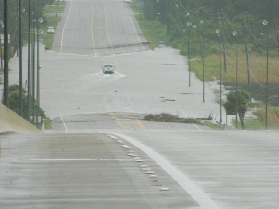
A Look Back At Hurricane Isaac. Some interesting details from
earthsky.org: "
Hurricane
Isaac, the 9th named storm and 4th hurricane of the 2012 Atlantic
hurricane season, caused plenty of problems across portions of
Hispaniola and the United States during the last week of August. Isaac’s
slow movement after making landfall in the U.S. resulted in large
flooding across Louisiana and through neighboring states. The slow
movement brought upon more tropical moisture to push into the southeast
providing flash flooding for parts of Mississippi and Alabama. For some
areas, the threat for severe weather and tornadoes were a huge concern."
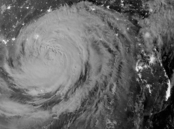
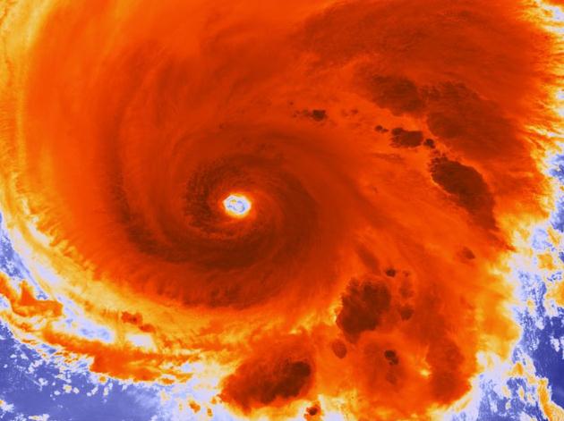
Image credit above: "
Visible Infrared Imaging Radiometer
Suite on the Suomi-NPP satellite captured this nighttime view of
Hurricane Isaac and the city lights early on August 29, 2012." Image Credit: NASA.
Awareness Of Flood Risks Remains Low: Swiss Re Report. Here's an excerpt of an interesting story at
Business Insurance: "
No
other natural catastrophe affects as many people as flooding, but
awareness of flood risks and their impact remains relatively low,
according to a report released Thursday by Swiss Re Ltd. The report,
“Flood — An Underestimated Risk: Inspect, Inform, Insure,” says that
insured flood losses have increased significantly in recent decades,
amounting to $15 billion in 2011. The report says that population
growth, higher concentrations of assets in exposed areas and climate
change are among the factors contributing to the increased cost of
flooding."
We Need Ratings For Snowstorms And Heat Waves. I've
written about this in the past, especially when it comes to snowstorms. A
newspaper in Grand Forks gave major winter storms names of famous local
hockey players and politicians years ago, but it didn't last. A rating
scale from 1-5, much like tornadoes and hurricanes, might make more
sense, and help to set expectations. Isaac was, on paper, a Category 1
hurricane, but the size of the storm and central pressure made it
something closer to a Category 2-3 storm, as described in this post at
The New York Times; here's an excerpt: "
...For
instance, Isaac was rated as a Category 1 storm at its peak intensity,
but it was Category 1 only in terms of its maximum wind intensity. Its
central pressure, of 964 millibars, would have given it a weak
Category 3 rating, and its storm surge qualified it as a Category 2 or
3. Its size, had that been a consideration, would probably have ranked
as a 4. So if we had a weighted ranking system, Isaac would have come
in as slightly over a 2.5 storm. The billions of dollars of damage
caused by Isaac and its impact on the affected region would have
justified this higher ranking."
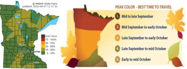
"Ask Paul". Weather-related Q&A:
Dear Mr. Paul Douglas-
"Here is the yearly question on where & when to
view the best fall colors in MN. Pardon me if you already answered this
question, can you send me the link if so?
1. Where in Minnesota is Peak fall color going to be the best on Oct 1st? (given the choices of North Shore- Gooseberry falls, Hinckley, Stillwater, Red Wing, Winona)
2. Is
it true north shore colors are better than Red Wing – Winona area
because North Shore had better rain fall and southern MN in drought?
3. When do you forecast peak colors for Gooseberry Falls area?
4. When do you forecast peak colors for Red Wing – Winona area?
I realize the Minnesota DNR has this info, but I’m banking on your help for a romantic fall getaway with my lovely wife!"
Thank you,
Steve Grimm, Sales Estimator
Advanced Response Systems
Steve - you are a hopeless romantic. God knows you could teach me a
trick or two. Sadly, I am a bewildered meteorologist; the science of
leaf-tracking is a niche within a science within a science. I too have
to rely on the Minnesota DNR, which has a
comprehensive list
of parks and trails with the latest leaf-watching conditions. That
said, your best bet on October 1 should still be The North Shore, 30-90
minutes north of Duluth. That would be my first choice. It does seem
like the drought is accelerating color this year, so you may run into
pockets of amazing color closer to Hinckley and Sandstone as you drive
up I-35 (nasty construction, leave extra time). Historically leaves peak
in the metro in mid-October, but it may be a week or so earlier this
year. Good luck.
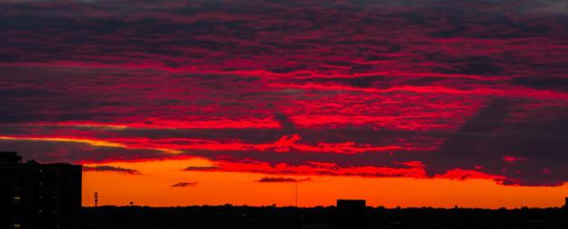
"
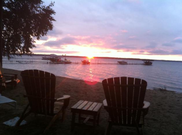
Paul,
thanks for continuing to post my sunset pic from Centerville Lake. What
an honor! Attached is a shot from (Friday night's) sunset from my new
apartment. I live just north of Target Field, and in a few months the
sun will be setting just over the field, which should make for some cool
pictures! This is obviously tightly cropped, but came out well.
Enjoy!"
Earthquake-Resistant Bed Can Withstand 65 Tons Of Falling Debris.
Come to think of it, this might not be a bad idea the next time an F-4
tornado catches me snoozing. For your friends in L.A. and the Bay Area?
Details from
gizmag.com: "
Following the lead of the Earthquake-proof school desk,
Wood Luck is an earthquake resistant bed that can withstand up to 65
short tons (59 metric tonnes) of falling debris. Designed by Shinko
Industries, the bed has been built to give users some “good luck”
protection during an earthquake. And with the ability to withstand 65
tons of tumbling detritus, it may just become a lifesaving piece of
furniture during an emergency situation."
Favorite recent gadget ("productivity tool"):
Dropcam. If you're looking for a way to keep an eye
on your home or cabin, or dock, or anything, and you have a WIFI signal
you can tap into - this is a terrific solution. It sets up in 5 minutes,
for PC or Mac, and sends back a live, HD stream accessible on any
desktop, tablet or smartphone. Pretty slick. You can even sign up for a
DVR service that records video from each webcam, so you can go back and
see if the kids were trashing the lakeshore 36 hours ago. It includes
audio (I can hear the hawks and crows up at my place north of Brainerd);
you can even speak into the system and talk to someone at the other
end. 2-way audio? What will they think of next. $149 from
amazon.com. And no, I don't get a commission.
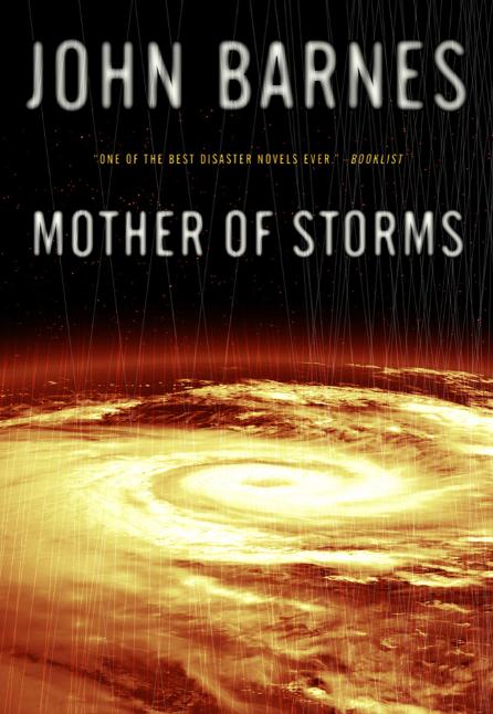
What I'm reading (as if anyone cares):
"Mother of Storms". A Category 12 hurricane? O.K.
This is set in the future (2028), and a sudden and catastrophic release
of methane in the Arctic has warmed the oceans to the point where
mega-hurricanes now circle the globe. Science fiction? I sure hope so.
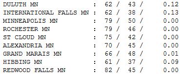
Windblown Saturday. Except for the whitecaps and
gale-force wind gusts it wasn't such a bad day. At least the sun was
out, and it was mild over central and southern counties. Tell that to
folks up in Hibbing, where the high struggled to 61 with .09" of rain.
Highs ranged from 62 at Duluth to 75 at St. Cloud, 79 Twin Cities and
Rochester and 82 at Redwood Falls.
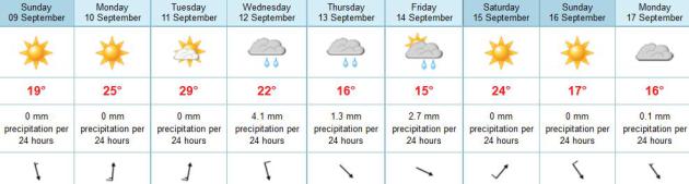
Paul's Conservation Minnesota Outlook for the Twin Cities and all of Minnesota:
TODAY: Cool sunlight. Less wind than yesterday. Dew point: 44. Winds: NW 10. High: 71
SUNDAY NIGHT: Clear and comfortably cool. Low: 50
MONDAY: Sunny and warmer. Dew point: 45. High: 81
TUESDAY: Hot sun, low humidity. Dew point: 49. Low: 65. High: 92
WEDNESDAY: Cooler. Clouds increase, PM showers. Low: 63. High: 72
THURSDAY: Rain south, cool sun up north. Low: 56. High: 68
FRIDAY: Clouds linger, cool & damp. Low: 52. High: 67
SATURDAY: Sun returns, lukewarm breeze. Low: 53. High: 75
Winter Mumblings
"Winter is not a season, it's an occupation"
wrote Sinclair Lewis. How true, especially at this latitude. It's human
nature to want to know what comes next. We just muddled through the 3rd
hottest summer on record. Only 1988 and 1933 were hotter. The Winter of
1988-89 brought a whopping 70 inches of snowy goodness. 1933-34? A wimpy
25 inches.
The severity of summer heat is NOT a good predictor of the winter to come.
NOAA expects an El Nino warming of the Pacific
to kick in later this month and linger into spring '13. A warm stain of
water may hijack the jet stream, keeping the southern US wetter, a
slightly drier, warmer bias for northern states, including Minnesota.
Would I bet the farm on that? No way.
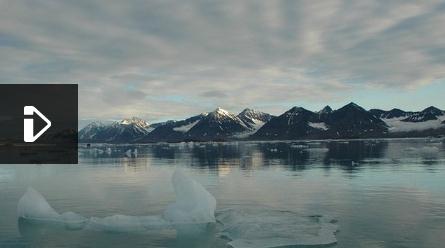
Record ice loss and warming over the Arctic may have unforeseen effects here at home.
I do expect recent trends to continue: fewer subzero blasts, more sporadic snows and warmer nights.
I suspect Minnesota's drought will get worse this month; no rain until the end of next week.
A comfortable, blue-sky Sunday gives way to 80F
Monday, highs top 90F on Tuesday. That would be the 31st day at or above
90 this year.
If this keeps up we may just lose our chilly reputation.
Climate Stories...
Those With Conspiracy Beliefs Apt To Deny Global Warming Too.
MSNBC.com has the story; here's an excerpt: "
A
study suggesting climate change deniers also tend to hold general
beliefs in conspiracy theories has sparked accusations of a conspiracy
on climate change-denial blogs. The research, which will be published in
an upcoming issue of the journal Psychological Science, surveyed more
than 1,000 readers of science blogs regarding their beliefs regarding global warming.
The results revealed that people who tend to believe in a wide array
of conspiracy theories are more likely to reject the scientific
consensus that the Earth is heating up."
Photo credit above:
Nicolle Rager Fuller, National Science Foundation. "Even
after years of research, scientists, policymakers and the general
public still can’t seem to agree that climate change is a problem, let
alone on how to address the changes the Earth is undergoing."
Disease-Spreading Ticks On The Move As Climate Changes. Here's a lovely symptom of warming from News Watch at
National Geographic: "
The
blood-sucking, disease-spreading parasites are expanding into new
territories as wildlife populations, forest habitats and weather
patterns change across North America, biologists have found. “This
year’s mild winter and early spring were a bonanza for tick populations
in the eastern United States,” the National Science Foundation said today. “Reports of tick-borne disease rose fast.” While Lyme disease
is the most common tick-borne disease in the Northeast and Upper
Midwest, new research finds that it is not the greatest cause for
concern in most Southeastern states, the NSF said in a news statement about a research paper in the journal Zoonoses and Public Health."
Photo credit above: lovely huh? "
A female blacklegged tick converting its blood-meal into thousands of eggs." Credit: NSF/Graham Hickling, University of Tennessee
Obama Counterpunches On Climate Change. Here's a clip from a
New York Times story: "
Mitt Romney, the Republican presidential nominee, took a not-too-subtle jab at President Obama in his convention speech
last week, mocking Mr. Obama’s soaring 2008 campaign language about
rolling back the rising seas and healing the planet. Mr. Romney’s gibe
drew thunderous applause from the Republican delegates, many of whom
express doubt about the existence of climate change. Mr. Obama jabbed
back on Thursday night in his acceptance speech
while detailing his energy program, which includes increased
investment in renewable energy and higher mileage standards for
vehicles. “And, yes,” the president said, “my plan will continue to
reduce the carbon pollution that is heating our planet – because
climate change is not a hoax. More droughts and floods and wildfires
are not a joke. They are a threat to our children’s future. And in this
election you can do something about it.”
Arctic Ice Melting At "Amazing" Speed, Scientists Find. Details (and a video) from
The BBC; here's an excerpt: "
Norwegian
researchers report that the sea ice is becoming significantly thinner
and more vulnerable. Last month, the annual thaw of the region's
floating ice reached the lowest level since satellite monitoring began,
more than 30 years ago. It is thought the scale of the decline may
even affect Europe's weather. The melt is set to continue for at least
another week - the peak is usually reached in mid-September - while
temperatures here remain above freezing."
Hurricane Link To Climate Change Explained. Here's an except from an important interview at
Discovery News. Is there a link?
Discovery News: At the risk of asking you to distill
complex science into a simplistic soundbite: Is climate change
affecting the number and intensity of cyclones and hurricanes?
Kerry Emanuel: Most of us think that we are
seeing a climate change signal in the North Atlantic, which is by far
the best observed and has been observed for the longest period of time;
but I hasten to add that only about 12 percent of the world’s tropical
cyclones occur in the Atlantic. The other parts of the world are not
so well observed.
What we expect from a combination of theory and modeling is that
as the climate warms, the actual total number of these storms should
decline globally, but the incidence of the severe Category 3, 4 and 5
storms is expected on the other hand to go up. And we do see some
indication that the proportion of hurricanes that are intense around
the world has been going up, although our data is a bit tenuous and is
not for very long, so nobody has a great deal of confidence in it.
Politicians Who Deny Climate Change Cannot Be Pro-Business. Here's a portion of a recent Op-Ed at
Bloomberg: "
It
finally seems to be dawning on many Americans that there's something to
this climate change thing. The historic drought has been hard to
ignore. While belief in a long-term trend because it's hot out right now
is a bit ridiculous, it's a start. You can see a shift in how the media
covers weather. The statement "because of climate change..." is often
stated clearly without caveats such as, "what some scientists think may
be a warming planet." You see it in the UN calling for action to help
the hungry cope with rising food prices "in an age of increasing
population, demand and climate change." And you see it in the growing
number of mega-corporations — including America's Alcoa, Coca-Cola,
Cisco, HP, J&J, Nike, and P&G — signing on to the "2 Degree
Challenge Communiqué," a call for the world's governments to take strong
action to slow greenhouse gas emissions."
The Motivated Rejection Of Science. Here's an excerpt from
Slashdot: "
"New research (PDF) to be published in a forthcoming issue of Psychological Science has found that those who subscribed to one or more conspiracy theories
or who strongly supported a free market economy were more likely to
reject the findings from climate science as well as other sciences. The
researchers, led by UWA School of Psychology Professor Stephan
Lewandowsky, found that free-market ideology was an overwhelmingly strong determinant of the rejection of climate science.
It also predicted the rejection of the link between tobacco and lung
cancer and between HIV and AIDS. Conspiratorial thinking was a lesser
but still significant determinant of the rejection of all scientific
propositions examined, from climate to lung cancer. Curiously, public
response to the paper has provided a perfect real-life illustration of the very cognitive processes at the center of the research."
Company Profits Unaffected By Climate Change Laws: Poll.
The business community doesn't seem very concerned about risks
associated with a warmer, stormier climate. Perhaps they're not paying
attention. Here's an excerpt from a story at
Bloomberg Businessweek: "
Almost
50 percent of global investors in a survey said government efforts to
combat climate change will have little effect on corporate profits,
while most say global warming is a danger to the planet. Actions to
limit pollution will have “not much impact” on profitability, according
to 49 percent of respondents in the Bloomberg Global Poll, while a third
said profit may fall. Eight percent of the investors, analysts and
traders surveyed among Bloomberg’s global customers said such efforts
would have a positive impact on corporate profitability in their nation.
Overall, 38 percent of investors said climate change was a major threat
to the environment, down from 48 percent in July 2009. Forty percent
called it a minor threat in the most recent poll and 19 percent said
warming presents no real threat."
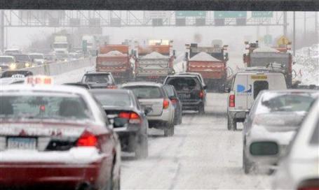
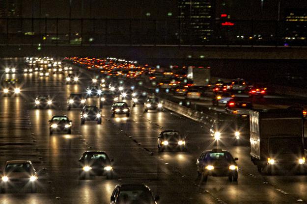
Photo credit above: "
Cars travel along Interstate 80 in
Berkeley, California. President Barack Obama’s administration has
required automakers to double the average fuel economy of passenger
vehicles sold in the U.S. by 2025." Photographer: Chip Chipman/Bloomberg.


No comments:
Post a Comment