78 F. high at 12:10 am Wednesday. Afternoon highs in the metro were closer to 64, a 30-40 degree temperature drop in 24 hours.
73 F. average high for September 12.
90 F. high on September 12, 2011.
.09" rain fell yesterday at Twin Cities International Airport. It was the wettest day since August 15, when .73" fell.
49 dry days in a row in Seattle, the second longest stretch on record (old record: 51 days in 1951).
Seattle Times.
100 days above 80 F. this year in Chicago. All-time record: 103 days. 46 days at or above 90 F.
31 days at or above 90 F. this year, a three-way tie for the
7th most days of 90+ since 1891. Got it? Source: NOAA.
1939. The last time we saw a 95 F. high temperature on, or after, September 11. Details:
Last time it was 95 degrees or warmer on or after September 11th was in 1939...
(Tuesday)
marked only the 8th time (and 5th year) in the 139-year Twin Cities
record where the max temp reached or exceeded 95 degrees F on, or after,
9/11. It was the first time this has happened since 1939.
Date Max Temp
09/11/1895 96
09/17/1895 96
09/11/1931 96
09/22/1936 95
09/13/1939 95
09/14/1939 98
09/15/1939 98
09/11/2012 95
* information above courtesy of the
Twin Cities National Weather Service. Photo above: MainStorm Tower.
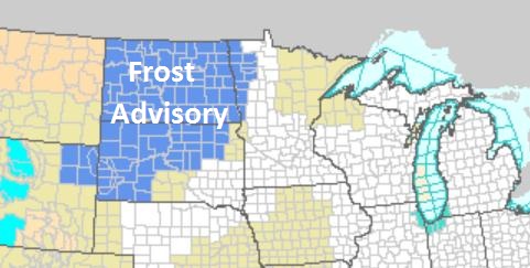
Definition Of A "Cold Front". From 80s and 90s on a Tuesday to Frost Advisories on a Thursday morning, at least across the Dakotas and Red River Valley.
Looks Like Autumn. No rude smacks of numbing air are
brewing (yet), but next week start to feel like fall with a few days in
the 60s, maybe 50s by midweek. The ECMWF (European) model doesn't show
any significant rain looking out 7-10 days.
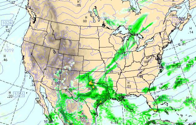
Today's Weather Map. Another quiet day is shaping up
for most of the USA, an eastbound cool front sparking mostly light
showers from Milwaukee and Chicago to St. Louis; heavier showers and
T-storms over Texas and Louisiana. Warm, dry, sunny weather will
dominate the west. WRF model valid 4 pm courtesy of NOAA.
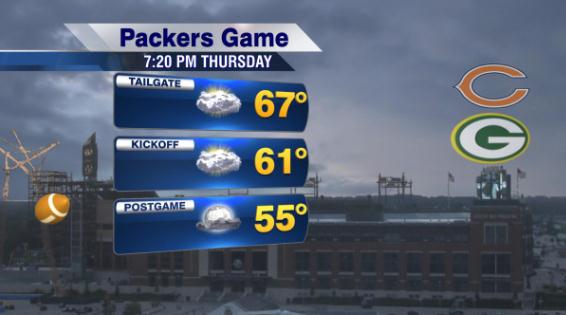
Classic Green Bay Weather. Expect temperatures mostly in the 50s for this evening's game in Green Bay - probably dry.
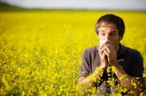
Yes, Your Allergies ARE Worse This Year. KARE-11
confirms what those of us who suffer from allergies already know: the
drought is making things worse. Check out the video; here's an excerpt
of the story: "
If you're going through tissues like they're going
out of style, you're not alone. It's ragweed season, and it's a doozy.
"This time of year I take my prescription allergy medication but I also
take Sudafed on top of that, plus I quadruple the strength of my
asthma inhaler," says Kristine Crossman-Little. Kristine is like
thousands of others who always suffer at the end of summer, but this
year seems to have an extra allergy kick. Why? there are a couple of
reasons. First of all, the weather has been nice, which means you're
likely spending more time outdoors with the pollen. Then, there's the
fact that it has been so dramatically dry."
Allergy Season Made Worse By Drought. Just what you wanted to hear. Details from
KWWL-TV in Dubuque:
"Many
Iowans have found the symptoms of allergy season are bad this year.
Ragweed, a plant native to Iowa, is the main cause of what people
commonly call hay fever. Due to the drought, the pollen count is
especially concentrated. Rain helps wash away a weed's pollen, according
to Bob Hartzler, weed specialist with the Iowa State University
extension office and ISU professor of agronomy. With a drought this
summer, he said, wave after wave of pollen has entered the air -- and
people's sinuses. "The fall of the year tends to be very problematic
for allergy sufferers, especially those that are pollen allergic,"
allergy and asthma doctor Brad McClimon said Tuesday afternoon at
Medical Associates in Dubuque. "The weeds, such as ragweed, tend to
pollinate in the fall of the year, from about mid-August until the first
frost, so we're right in the midst of the pollen season."
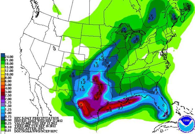
Southern Soaking. NOAA HPC is
predicting some 3-4" rains from near Dallas and Austin to New Orleans
over the next 5 days, bone-dry weather west of the Rockies.
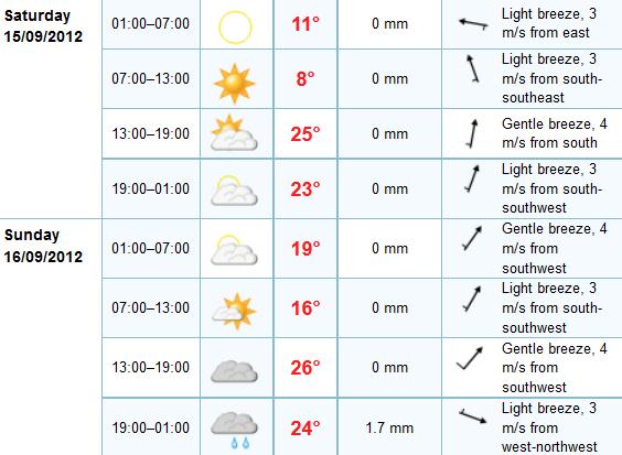
Weekend Preview. Another 3-star, blue-ribbon,
award-winning weekend is shaping up, Saturday probably the sunnier day
with highs in the mid 70s. The mercury may approach 80 Sunday as clouds
increase, the ECMWF model hinting at showers, maybe a clap of thunder
late Sunday into Monday morning as the next cool front approaches.
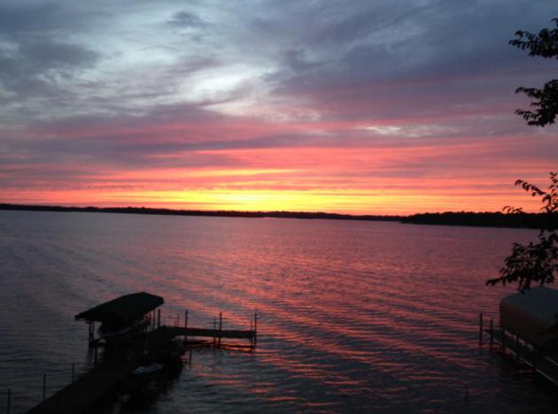
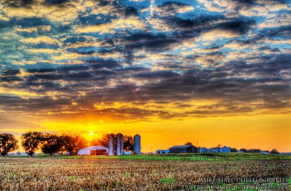 Sunset On Muddy Gut Road
. Mike Hall snapped this terrific shot near Hancock, Kentucky late yesterday. Perfect.
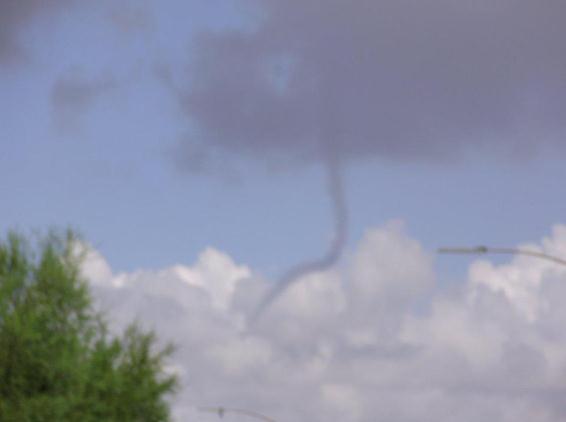
Funnels In Unlikely Places. The Tucson, Arizona
office of the National Weather Service snapped this photo of a funnel
hovering over the Oro Valley. Details via
Facebook: "
An
employee with the Oro Valley Police Department snagged this photo of a
funnel cloud today over Oro Valley. The picture is a little blurry, but
you can still clearly make out the funnel. The funnel lasted but a few
short moments before dissipating. Did anybody else notice the funnel
today?"
 Wall of Water
. Thanks to
WeatherNation TV for passing this one along. I'd say at least a 30% probability of a shower.
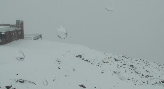
Snow Season Returns. Here's an update on Pikes Peak from the
Pleasant Hill, Missouri office of the NWS: "
While
temperatures are expected to climb near 90 today, here is just another
reminder that the Fall season and then Winter season are approaching
rapidly. Winter fans will love this shot from Pikes Peak in Colorado
this afternoon as the first snowfall of the year falls above the tree
line with a current temperature of 28 degrees! Some mountain areas are expected to receive upwards of 10" of snow by tonight."
New App Provides Green Fuel Map For The U.S. If you own a hybrid, or use E-85 fuel for your vehicle, this free app might come in handy; details from gizmag.com: "Switching
to a vehicle running on alternative fuel presents a clear challenge -
where do you fill it up? Designed by Leonardo Academy, Cleaner and
Greener Fuels is a free app that gives users interactive maps to help
them find the nearest alternative fuel stations all over the U.S.
Available for both iPhone and Android devices, the app caters for
electric cars as well as vehicles running on CNG (Compressed Natural
Gas), Biodiesel, LNG (Liquefied Natural Gas), E85, LPG (Liquefied
Petroleum Gas, also known as propane) and hydrogen. The information is
based on the database compiled by the Department of Energy’s Alternative
Fuels & Advanced Vehicles Data Center (AFDC)."
Apple Introduces iPhone 5. Wait, did Apple just
release a new smart phone? I had no idea. Yeah - I'm a fanboy. I tried
Android and it compared directly with the iPhone, and I preferred the
latter. It's just a better ecosystem. I prefer to invest my money in the
innovators, not the imitators. Here are some of the latest specs,
courtesy of
Apple: "
Apple®
today announced iPhone® 5, the thinnest and lightest iPhone ever,
completely redesigned to feature a stunning new 4-inch Retina™ display;
an Apple-designed A6 chip for blazing fast performance; and ultrafast
wireless technology*—all while delivering even better battery life.**
iPhone 5 comes with iOS 6, the world’s most advanced mobile operating
system with over 200 new features including: the all new Maps app with
Apple-designed cartography and turn-by-turn navigation; Facebook
integration; Passbook® organization; and even more Siri® features and
languages. “iPhone 5 is the most beautiful consumer device that we’ve
ever created,” said Philip Schiller, Apple’s senior vice president of
Worldwide Marketing. “We’ve packed an amazing amount of innovation and
advanced technology into a thin and light, jewel-like device with a
stunning 4-inch Retina display, blazing fast A6 chip, ultrafast
wireless, even longer battery life; and we think customers are going to
love it.” iPhone 5 is the thinnest smartphone in the world, with an
all-new 7.6 mm anodized aluminum body that is 18 percent thinner and 20
percent lighter than iPhone 4S. Designed with an unprecedented level
of precision, iPhone 5 combines an anodized aluminum body with diamond
cut chamfered edges and glass inlays for a truly incredible fit and
finish."
* CNET.com has a comprehensive review of the iPhone 5
here.
CruxSKUNK Case Converts iPad Into A Laptop. Details from our techno-geek buddies over at
gizmag.com: "
The CruxSKUNK is a new case for the iPad, designed to make your device look and feel like a laptop. There are already plenty of iPad cases with keyboards built-in,
but most of them look like standard cases, and do little to add style
to the iPad itself. With this new case, however, you might actually
confuse your iPad for your laptop."
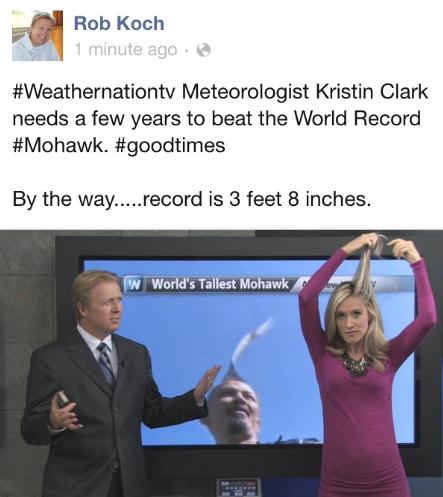
You Never Know What You'll See On WeatherNation TV.
Yes, we take the weather seriously 24/7 on KARE-11.2 and cable systems
statewide, but we try not to take ourselves too seriously. It was a
relatively quiet weather-day. That's Rob Koch next to meteorologist
Kristin Clark, the one with the new mohawk. Nice try Kristin.
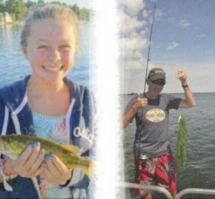
Skunked By My Niece. Elizabeth caught a nice litlte
walleye. Her clueless uncle? Nothing but weeds. Story of my life. There
are fish up in Pelican Lake - I just haven't been able to catch many...
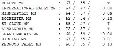
A Rare Rain Event. No, it wasn't nearly enough rain,
but I was reassured by the fact that it can still rain in the metro
area. The streak of rain set up 50-100 miles farther north than the
models were suggesting Tuesday. Rochester and Redwood Falls picked up
.13", just a trace at St. Cloud. Under a gray sky afternoon highs ranged
from 62 at Rochester to a sloppy 64 at MSP, 68 St. Cloud and 72 at
Alexandria, where the sun was out by afternoon (behind the front).
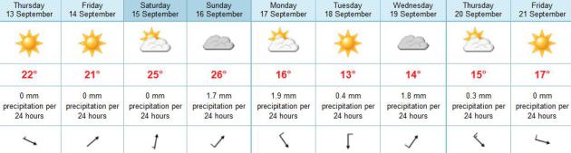
Paul's Conservation Minnesota Outlook for the Twin Cities and all of Minnesota:
TODAY: Partly sunny, pleasant. Winds: NW 10. High: 71
THURSDAY NIGHT: Clear and cool. Low: 48
FRIDAY: Bright sun, less wind. DP: 29 (!) High: 72
SATURDAY: Sunny, breezy, warmer. Winds: S 10-20. Low: 49. High: 80
SUNDAY: Fading sun, still lukewarm. Low: 56. High: 81
MONDAY: Showers, then gusty, colder. Low: 57. High: 65
TUESDAY: Sunny and brisk. Low: 46. High: 61 (50s for greater Minnesota)
WEDNESDAY: Unsettled, passing shower. Low: 49. High: 68
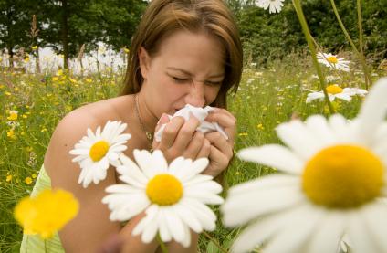
Plenty to Sneeze At
Sneezing and wheezing, gurgling and sputtering -
allergy-sufferers are not happy. Yesterday's (rare) rain event helped
to bring some of the pollen to the ground, but a deepening drought has
set the stage for a rough season. Ragweed is in full bloom from
mid-August until the first frost, which is probably 2-3 weeks away. In
the meantime common sense applies: shut the windows, turn on the A/C,
and shower immediately after spending time outside.
That strange, liquid-substance falling out the
sky yesterday was "rain". Roads were slick; oils can build up on highway
surfaces; add a little rain or mist at the beginning of a storm or
frontal passage and you can wind up fishtailing down the interstate.
No significant rain in sight for the next week.
Skies clear; highs near 70 today and Friday. A south wind returns for
the weekend, with highs approaching 80. Soak it up, because next week
may feel more like October. The first flakes of autumn are possible over
the North Shore of Lake Superior Monday night; an Alberta Clipper
pushes even colder air into town late next week.
I suspect central and northern Minnesota will see their first frost within 10-14 days. Metro area? Early October.
Climate Stories...
Climate Change Will Extend Hay Fever Season By Six Weeks.
Oh that's just great. I'm liking the milder trends to some extent, but 6
more weeks of sneezing, wheezing and sniffling? Details from The
Guardian and
Mother Jones: "
Hay
fever sufferers face longer pollen seasons and highly allergenic new
strains from invasive plants, a new report on the health effects of
climate change on the UK warned on Tuesday. Global warming will cause
earlier flowering, possibly extending the hay fever season by six
weeks, and enable new species to grow in the UK. Pollen is also
getting more potent, packing more allergen into each grain. The report,
from the Health Protection Agency
(HPA), analyses a wide range of risks including killer heatwaves,
increased flooding, greater food poisoning and new infectious diseases
carried by mosquitoes."
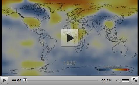
Hot Graphics - Global Warming In Images. Here's a
snippet of a post that summarizes the global trends we're witnessing in
recent decades with excellent visuals and animations; from
getenergysmartnow.org: "..
This NASA graphic impressively provides 131 years of temperature data in 26 seconds. "The
global average surface temperature in 2011 was the ninth warmest since
1880, according to NASA scientists. The finding continues a trend in
which nine of the 10 warmest years in the modern meteorological record
have occurred since the year 2000. … The comparison shows
how Earth continues to experience warmer temperatures than several
decades ago. The average temperature around the globe in 2011 was 0.92
degrees F (0.51 C) warmer than the mid-20th century baseline."
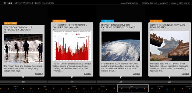
Extreme Weather & Climate Events: 2012.
Here is a remarkable timeline summary of 2012: the warmest, and
probably the most severe year in U.S. history, but an unusual number of
extremes were witnessed worldwide. Check it out for yourself at
tiki-toki.com.
Heat: A Bridge To Climate Consensus? Huffington Post has the story; here's an excerpt: "
Excessive heat is becoming a public health threat, especially in cities. It leads to heat stroke, heat exhaustion, and is a catalyst for ground-level ozone creation as well as asthma and lung disease.
However, and perhaps even more importantly, heat may be the bridge to
climate consensus. While extreme heat is not climate change in itself,
it amplifies the heat impacts of climate change
-- thus also amplifying the threats to human health. It therefore
provides an opportunity that allows climate believers, agnostics, and
deniers to work together to address a common threat to our society.
Regardless of the motivations, dealing with extreme heat can help
mitigate climate change, providing added benefits to society."
Arctic Warning: As The System Changes, We Must Adjust Our Science. Here's an excerpt from
Climate Code Red: "
The Arctic sea-ice big melt of 2012 “has taken us by surprise and we must adjust our understanding of the system and we must adjust our science
and we must adjust our feelings for the nature around us”, according
to Kim Holmen, Norwegian Polar Institute (NPI) international director.
From Svalbard (halfway between mainland Norway and Greenland), the BBC’s
David Shukman reported
on 7 September that Holmen had described the current melt rate “a
greater change than we could even imagine 20 years ago, even 10 years
ago”.
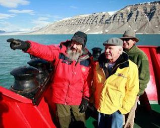
Photo credit above: "
Northern Polar Institute Research
Director Kim Holmen, left, with UN Foundation Board Chairman Ted Turner
and President Timothy Wirth in the Arctic."
Faking That NASA Faked The Moon Landing. More on conspiracy theories and a possible link to ongoing climate change denial from
shapingtomorrowsworld.org: "
Data
integrity is a central issue in all research, and internet-based data
collection poses a unique set of challenges. Much attention has been
devoted to that issue and procedures have been developed to safeguard
against abuse. There have been numerous demonstrations that internet
platforms offers a reliable and replicable means of data collection,
and the practice is now widely accepted. Nonetheless, each data set must
be examined for outliers and “unusual” responses, and our recent paper
on conspiracist ideation and the motivated rejection of science is no
exception. Perhaps unsurprisingly, after various unfounded accusations
against us have collapsed into smithereens,
critics of our work have now set their sights on the data. It has been
alleged that the responses to our survey were somehow “scammed,”
thereby compromising our conclusions."
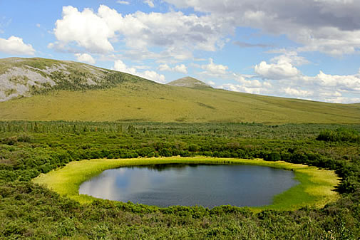
Permafrost Thaw Will Speed Up Global Warming, Study Says.
CBC News has the story; here's an excerpt: "
Permafrost
soils in Canada's Arctic are melting at a rate that will significantly
speed up global warming, according to new research from the University
of Victoria. The study, published this week in Nature Geoscience,
predicts that the thawing permafrost will release between 68 billion
and 508 billion tonnes of carbon into the atmosphere by the year 2100.
As a result of those carbon emissions, researchers say the Earth's
temperature will rise by more than 0.5 C by the end of the century." Image above: NASA.


No comments:
Post a Comment