95 F. high yesterday, just 1 degree away from the record of 96 F, set in 1931.
99 F. high in Madison, Minnesota Tuesday.
32 mph. Peak wind gust yesterday at KMSP.
74 F. average high for September 11.
89 F. high on September 11, 2011.
Too Dry. The ECMWF shows a return to more
comfortable temperatures the next few days: 60s and low 70s, before
warming up to near 80 by Sunday. A more significant cool front is
shaping up by next Tuesday; highs in the 50s and 60s. No freakishly cold
weather, just a gradual slide into more typical, September-like
weather. I still don't see anything resembling a "storm" with
significant rain looking out 7-10 days.
"...The urban heat island in large cities has been shown to delay
fall color by 1-2 weeks, compared to surrounding areas, and that
effect is thought to be due to warmer nights.." - Lee Frelich, Director of the University of Minnesota Center for Forest Ecology; his full comments below.
"Matthew Nisbet,
an associate professor in the School of Communication at American
University, and colleagues have found that people who are indifferent,
or even hostile, to climate change are more receptive to the issue when
it's talked about as a health issue." - from an article focused on the health implications of a warming climate at NPR.
"
The whole issue of climate change is now so intensely
politicized and so intensely fought over, if you put a foot wrong in
any regards, if you make a claim that can't stand up, it then becomes
ammunition in this intense culture battle that we have." - George Marshall, Climate Outreach Information Network, from an NPR story below.
"...
Or an iced area larger than Alaska, Texas and California
combined melted away in 31 days last month while you and I carried on
our usual business. And it's still melting. Should we be concerned?
What do you think?" - from Doug Craig's eye-opening Climate of Change post at redding.com; details below.
First Flakes? No need to hyperventilate, panic or
call your mother just yet, but the GFS is hinting at temperatures in the
lowest 4,000 feet cold enough to support the first flurries of the
season over North Dakota by Tuesday morning of next week. Something to
look forward to.
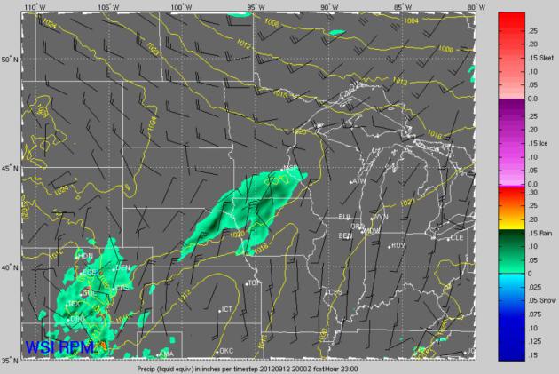
The Edge of Dampness. Will it actually rain? I'm
having my doubts. The high-resolution, 12-kilometer RPM model from WSI
shows a smear of light rain over southern Minnesota at 3 pm, the best
chance of puddles south of the metro area.
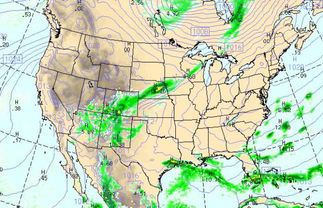
Today's Weather Map. NOAA's WRF model, valid 4 pm
today, shows a streak of light rain from Denver to Sioux City to Eau
Claire, showers along the leading edge of cooler air. More heavy
T-storms are predicted for Florida, a surge of Gulf moisture pushing
rain into Houston, more showers and T-storms over the four-corners
region of the southwest. Otherwise dry weather prevails.
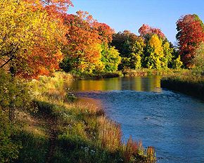
Will Dry Weather Impact Minnesota's Fall Foliage?
The answer is a qualified yes, at least for unwatered trees in the metro
area. I posed this question to Lee Frelich, Director of the University
of Minnesota Center for Forest Ecology. Here is his e-mail response:
"
For most species of trees, droughts, and cool late summer/early
fall temperatures bring on fall color, whereas wet weather and warmer
late summer/fall temperatures delay fall color. For a few species of
trees, early versus late spring also plays a role, since their leaves
only last a certain length of time, so that an early spring causes
leaves to fall off earlier.
I think we are seeing the effects of the developing drought on
trees right now in the Twin Cities area. I don't think the August cool
spell was cool enough to affect trees here, but it probably was in
northern MN. 8-10 days of temperatures at night in the 40s are needed to
trigger fall color development. The urban heat island in large cities
has been shown to delay fall color by 1-2 weeks, compared to surrounding
areas, and that effect is thought to be due to warmer nights.
It's interesting that we have hardly any fall color development
on campus in St. Paul - the lawns here are watered and trees are not
under drought stress, but just off campus, unwatered trees are shedding
leaves."
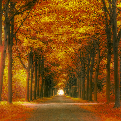
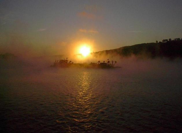
* photo credit above: Flickr.
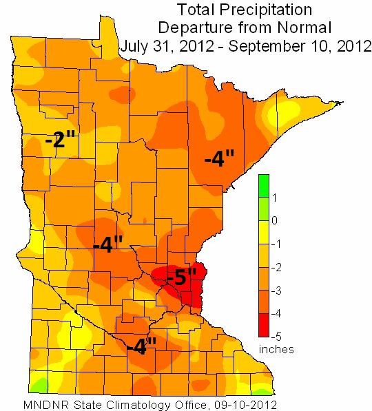
Rainfall Departure From Normal Since July 31. The
north metro is running a 4-5" rainfall deficit since August 1, most of
Minnesota trending (much) drier than average. Details and
more maps explaining the evolving drought from The Minnesota Climatology Working Group: "
The
abnormally dry conditions in central and east central Minnesota
developed rapidly during the month of August and during early September
with many locations reporting less than one and one-half inch of
rainfall."
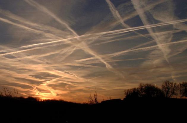
Airplane Contrails And Their Effect On Temperatures.
In light of 9/11 I wanted to repost an article that highlighted
research into the impact of jet contrails on surface temperatures. After
planes nationwide were grounded by the FAA in the wake of the terrorist
attack, meteorologists noticed something curious: air temperatures
spiked by 1-2 F. The theory: no jets meant no jet contrails, high thin
cirrus clouds at 25,000 feet, which can have a slight cooling effect
during the day, a warming effect at night. Here's an excerpt from The
Christian Science Monitor: "
...Then
Sept. 11, 2001 presented a unique opportunity to study what the sky
looked like without airplanes and contrails. In the wake of the 9-11
terrorist attacks, the FAA prohibited commercial aviation over the United States for three days. That's when David Travis, an atmospheric scientist at the University of Wisconsin, Whitewater, thought to look at how temperatures might differ at temperature stations around the country. He found that
[PDF], for those three days, the average range between highs and lows
at more than 4,000 weather stations across the US was 1 degree C wider
than normal. In other words, contrails seemed to raise nighttime
temperatures and lower daytimes ones."
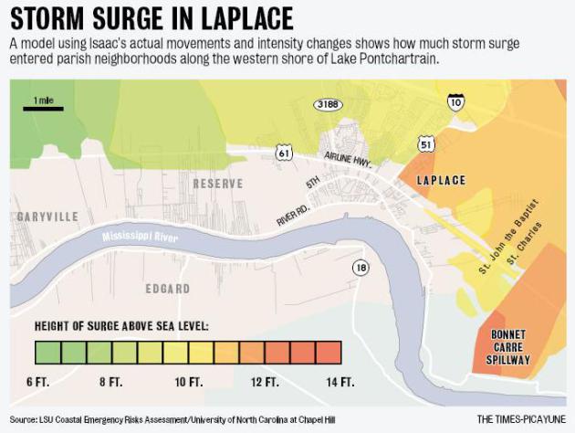
Surge Warnings Went Out Before Hurricane Isaac Hit.
There is still a huge amount of anger and indignation on the part of New
Orleans residents who live in parishes outside of the immediate metro,
unprotected from the new and improved levee system retrofitted in the
wake of Katrina in 2005. More from
NOLA.com: "
During the two days before Hurricane Isaac
plodded across southeastern Louisiana, parish and state officials were
given maps by federal weather forecasters and state and university
surge experts that detailed the significant storm surge flooding that
would occur in areas without levees, such as LaPlace, St. Tammany Parish and poorly protected locations on the east and west banks of Plaquemines Parish.
Some of those maps and detailed written warnings of storm surge
heights were issued directly to the public, but the public fixation on
Isaac's low Category 1 ranking under the outdated Saffir-Simpson system
likely led many residents to forgo evacuating those areas."
Map credit:
Times Picayune.
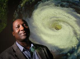
Researchers Devise More Accurate Method For Predicting Hurricane Activity. Here's an excerpt of a fascinating article from
NC State University: "
Researchers
from North Carolina State University have developed a new method for
forecasting seasonal hurricane activity that is 15 percent more
accurate than previous techniques. “This approach should give
policymakers more reliable information than current state-of-the-art
methods,” says Dr. Nagiza Samatova, an associate professor of computer
science at NC State and co-author of a paper describing the work. “This
will hopefully give them more confidence in planning for the hurricane
season.” Conventional models used to predict seasonal hurricane
activity rely on classical statistical methods using historical data.
Hurricane predictions are challenging, in part, because there are an
enormous number of variables in play – such as temperature and humidity
– which need to be entered for different places and different times.
This means there are hundreds of thousands of factors to be considered."
Photo credit: "
The researchers, including Dr. Fredrick
Semazzi (pictured), hope to use their new method to improve our
understanding of hurricane behavior."
Curiosities: How Are Hurricane Named And Who Names Them? I get this question a fair amount;
madison.com has a timely article that provides some answers; here's an excerpt:
Q: How are hurricanes named and who names them?
A: The first known scientific use of hurricane
naming arose in the Pacific during World War II. It was an easy and
effective way to distinguish one tropical cyclone from another on the
weather maps, said Steve Ackerman, a UW-Madison professor of
atmospheric and oceanic sciences and director of the Cooperative
Institute for Meteorological Satellite Studies. The system was simple
and alphabetical: The name of the first storm of the season would begin
with A; the second, B; the third, C; and so on.
Naming hurricanes, he added, also gave homesick soldiers a way
to recall loved ones. Thus began the practice by predominantly male
meteorologists of giving female names to hurricanes. This practice
persisted at the National Hurricane Center in Miami until the late
1970s.
Is Earth In Danger Of Solar Flares?
Great. One more thing to worry about. But solar activity is forecast to
peak in 2013, and there is a small, but not insignificant risk of a
solar flare large enough to impact communications and even power grids
here on Earth. Here's an excerpt from a not-so-comforting story at
My Fox Phoenix: "...
But
scientists warn a solar storm, if it's big enough, can knock out power
anytime, anywhere. "Once the magnetic field of the Earth starts to
change, that affects things on the day side and night side of the
planet, so the effects are global," said Penn. And the damage could be a
life changing event. Severe solar damage to SRP's power grid could
take more than a year to fix. "In a time of less strong demand, it might be as little as 10 to 12
months. In a time when electrical demand is expanding quickly, it might
be as much as 18 months or more," said Hunt. 18 months or more?"
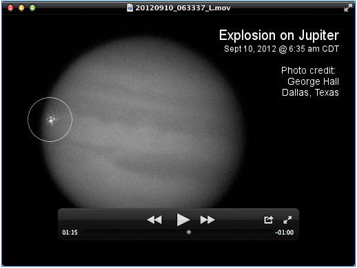
Explosion On Jupiter. Details from
spaceweather.com; here's an excerpt: "
Apparently,
something hit Jupiter during the early
hours of Sept. 10th (11:35 UT), igniting a
ferocious fireball in the giant planet's
cloudtops. Amateur astronomer Dan
Peterson Racine, Wisconsin, saw it first through
his Meade 12" LX200 telescope. "It was
a bright white flash that lasted only 1.5 - 2 seconds,"
he reports. Another amateur astronomer, George Hall
of Dallas, Texas, was video-recording
Jupiter at the time, and he confirmed the
fireball with this video screenshot
(above)."
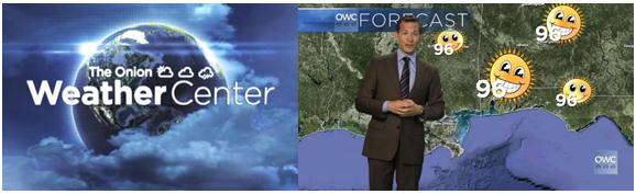
The Onion Weather Center: "We Dumb It Down The Best We Can For Our Viewers In The Deep South". Mildly offensive? You bet. Funny? You be the judge. More from
The Onion: "
The
Onion Weather Center delivers a very special weather report for all of
our very special viewers in the Deep South, who require a little extra
attention to help them understand that really big numbers mean hot
temperatures."
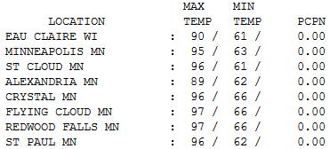
September Hot Flash. Upper 90s on the 11th day of
September? The way this year is going - the warmest in Minnesota history
- I guess we shouldn't be surprised. Under bright sun with gusty south
winds highs ranged from 89 at Alexandria to 95 Twin Cities, 96 St. Cloud
and 97 at Redwood Falls.
Paul's Conservation Minnesota Outlook for the Twin Cities and all of Minnesota:
TODAY: Much cooler- clouds increase, shower possible (steadier rain over far southern MN). Winds: W 10. High: 69
WEDNESDAY NIGHT: Mostly cloudy, more comfortable. Chance of a shower, mainly south of MSP. Low: 52
THURSDAY: More clouds than sun, brisk. High: 71
FRIDAY: More sun, a bit milder. Low: 49. High: 73
SATURDAY: Warm sunshine, a beautiful September day. Low: 51. High: 75
SUNDAY: Summer flashback. One last dip in the lake? Low: 57. High: near 80
MONDAY: Turning windy and cooler. Low: 58. High: 74
TUESDAY: Chill wind, light PM showers. Low: 51. High: 59
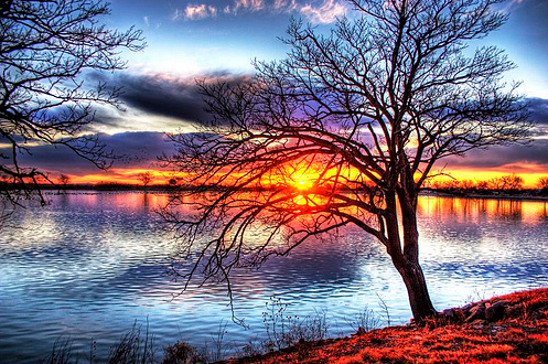
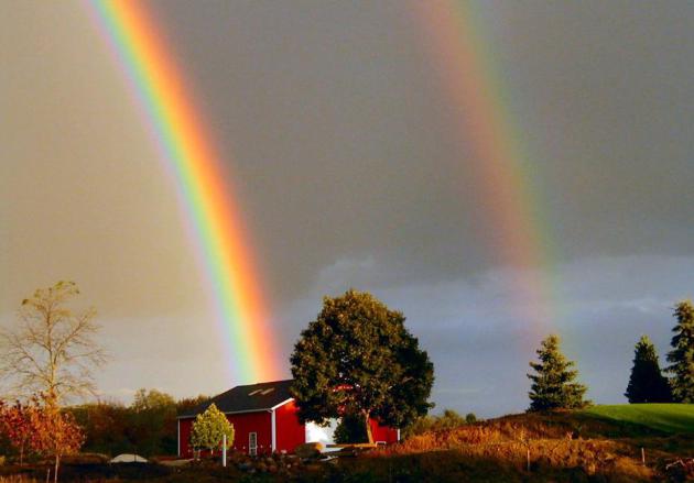
The Leaves are Leaving
It's dry out there; yesterday's Fire Warnings
more typical of Montana than Minnesota. Will a deepening drought have an
impact on the blaze of color on area trees in the coming weeks? I posed
that question to Lee Frelich, Director of the University of Minnesota's
Center for Forest Ecology.
"For most species of trees, droughts, and cool
late summer/early fall temperatures bring on fall color, whereas wet
weather and warmer late summer/fall temperatures delay fall color."
Frelich told me that 8-10 nights in the 40s are needed to trigger fall
color.
We haven't seen that yet, but dry weather may be
having an impact. "I think we are seeing the effects of the developing
drought on trees right now in the Twin Cities area". Frelich added that
irrigated trees in St. Paul are fine; off-campus (unwatered) trees are
shedding leaves.
We cool off today, 20 degrees cooler than
yesterday - a shower possible later; not nearly enough rain to put a
real dent in the drought. Skies clear and warm into the weekend; more
70s likely; 80 possible by Sunday.
It's almost time to drag your favorite jacket
out of cold storage - highs hold in the 50s by the middle of next week; a
vague, windblown hint of brisk days to come.
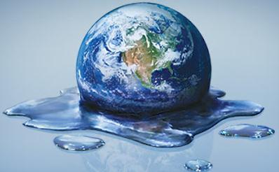
Climate Stories...
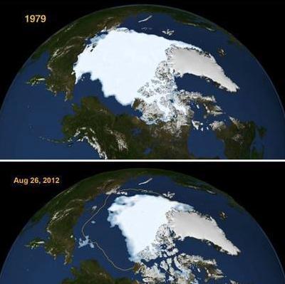
Canaries Of Climate Change (1). One of the things
I'm trying to do, in addition to sharing stories and posts that catch my
eye from day to day, is provide some perspective. Not only what is it,
but what does it MEAN, and why should I care? Doug Craig does a
remarkable job of putting Arctic ice melt into perspective in his
Climate of Change posts at
redding.com; here's an excerpt of a must-read entry: "...
And
get this. In 2007, the melt rate for August was 66,000 square
kilometers (25,400 square miles) per day. Each day in August of 2007 an area of ice the size of West Virginia melted
into the ocean. Every day. That means 31 West Virginias of ice
melted away that month. The following year it got worse. "In
August of 2008, the year with the previous highest August ice loss, the
rate was 80,600 square kilometers (31,100 square miles) per day."
That means that each day, an area of ice close to the size of South
Carolina vanished. The whole month. 31 South Carolinas. Melted away.
And this year it got worse yet. This year, "the rate of ice
loss for August was 91,700 square kilometers (35,400 square miles) per
day, the fastest observed for the month of August over the period of
satellite observations." An area of ice the size of Maine disappeared every day. 31 Maines of ice went bye-bye last month."
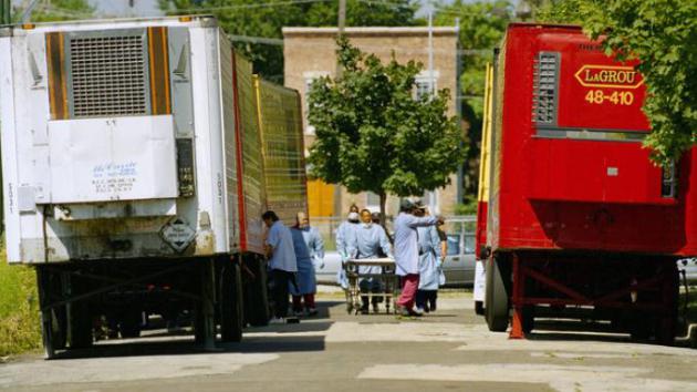
When Heat Kills: Global Warming As Public Health Threat.
I was living in Chicago in 1995, when a "heat storm", a deadly spike in
heat arrived, with very little advance warning. The Executive Producer
at the local station I was working at wanted to do a schtick piece for
the newscast, a back and forth with a meteorologist in Phoenix. "Which
city is hotter?" Hahahaha. I told her that people were going to die, to
position reporters at Chicago hospitals. We wound up getting into a
shouting match in the newsroom. "You don't get it!" she screamed. "You
don't get television!" That may be true, but in this specific case she
should have listened to her meteorologist. The next day: wall-to-wall
coverage of the 700+ heat deaths and a city-wide Chicago heat emergency.
Researchers discovered it wasn't so much the daytime heat as it was the
nighttime warmth; temperatures
stayed above 84 F for 3 nights. There was no relief, no chance for people to recover.
NPR has the story; here's a clip: "
The
current poster child for global warming is a polar bear, sitting on a
melting iceberg. Some health officials argue the symbol should,
instead, be a child. That's because emerging science shows that people
respond more favorably to warnings about climate change when it's
portrayed as a health issue rather than as an environmental problem.
Epidemiologist George Luber
at the Centers for Disease Control and Prevention says the most
obvious risk from a warming world is killer heat. A deadly heat wave
that struck Chicago in 1995 made many people aware of how disastrous
sustained high temperatures can be. About 750 people died from the heat
in Chicago, "and that was amplified by the European heat wave of 2003,
where we had over 70,000 excess deaths attributable to the heat wave,"
he says. Today, Luber's job at the CDC is to deal with health issues related to climate change. And heat waves are just part of his portfolio."
Photo credit above:
Mike Fisher/AP. "Cook
County morgue workers walk between a row of refrigerated trucks
outside the morgue in July 1995, when a deadly heat wave struck Chicago."
How Climate Change Could Make Summer Crime Waves Worse. There is a correlation between heat and crime. It's that simple.
The Atlantic looks at recent trends and research and connects the dots into the future; here's an excerpt: "
Chicago has suffered over the past few months from a particularly bad case of the twin maladies of summer in the city: heat and crime waves. In the last week of August alone, 82 people were shot in Chicago, including as many as 19
over a single mid-week night. As a depressing indicator of just how
common this news had become, the local media was reduced to reporting the shootings in bullet-point form.
The Chicago spree, as unusually severe as it has been, mimics a pattern
that researchers (and police officials and, heck, just about all of
us) have long observed. When temperatures go up, crime often does, too (last summer’s startling London riots were partly blamed on the weather)."
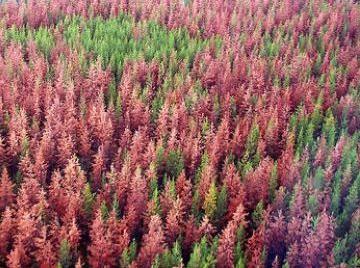
Forest Mortality And Climate Change: The Big Picture.
Warm weather isn't killing trees (directly). But it's allowing pests to
live yearround, bark beetles capable of weakening and destroying
millions of acres of vibrant forestland. Here's a clip from an article
at
labspaces.net: "
Over
the past two decades, extensive forest death triggered by hot and dry
climatic conditions has been documented on every continent except
Antarctica. Forest mortality due to drought and heat stress is expected
to increase due to climate change. Although research has focused on
isolated incidents of forest mortality, little is known about the
potential effects of widespread forest die-offs. A new analysis of the
current literature on this topic by Carnegie's William and Leander
Anderegg is published September 9 in Nature Climate Chang."
"TruthMarket". A Wikipedia for the truth?
Crowd-sourcing complex issues to find out what is based on rumor vs.
fact? An intriguing concept; more details at
pointofinquiry.org: "
Wouldn't
it be nice if there were a way to make American politics just a little
more rational, just a little more evidence based? Wouldn't it be even
nicer if there was a website, or an app, that helped that process along?
Maybe, just maybe, a promising innovation called TruthMarket can
help with the problem. It's a site where people who care about the
truth crowd-fund campaigns dedicated to either proving the veracity of
true claims, or the falsity of wrong ones... where, in essence, you make
money by showing definitively that you're right. The goal, of course,
is to use market forces to vanquish truthiness... and, well, here's
hoping that it works."


No comments:
Post a Comment