80 F. high in the Twin Cities Sunday.
72 F. average high for September 16.
60 F. high on September 16, 2011.
.25" rain predicted today (NAM
model)
30+ mph wind gusts possible today as colder air arrives.
 40 Degree Temperature Drop in 36 Hours
.
From 80 Sunday afternoon to 40 Tuesday morning, some upper 30s in the
outlying suburbs. Most of the metro area, even the outlying suburbs,
will probably avoid a killing frost late tonight. Graph: Iowa State.
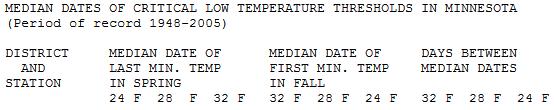
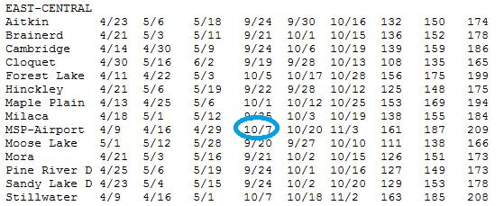 First 32?
 According to the Minnesota State Climate Office the average (median) date of the first 32 F. low at MSP
International
is October 7, but outlying suburbs usually see the first 32-degree
temperature the last few days of September. The first killing freeze (28
F. for several hours)
is October 20, on
average. At the rate we're going we may still see an early frost this
season, although I think most suburbs will avoid a frost this week.
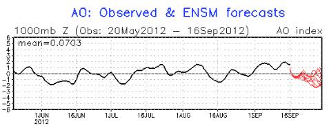
Greenland Block. Technically it's a
negative phase of the AO (Arctic
Oscillation). Translation: the jet stream winds are buckling, plunging
Canadian air southward in a pattern that may become temporarily "stuck",
at least for the next 1-2 weeks, sending a series of 3-4 separate
surges of Canadian air south of the border. Arctic Oscillation trend
since June 1 (and prediction for the next week) courtesy of
NOAA CPC.
ECMWF: Not Quite As Chilly As Previous Runs. With
the latest European model run Mother Nature pulls her cold punch just a
bit. Highs may hold in 50s to near 60 Tuesday, a second push of 50s by
Friday and Saturday before warming up a bit Sunday, probably the nicer
day of next weekend. A third surge of cool air arrives early next
week; more 50s by Monday and Tuesday of next week.
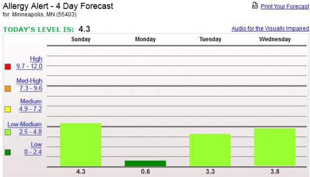
One Silver Lining To Today's Cold Front. Rain will
bring some of that nasty ragweed pollen to the ground today, resulting
in a (rare) Pollen Count in the low range. Graph above courtesy of
pollen.com.
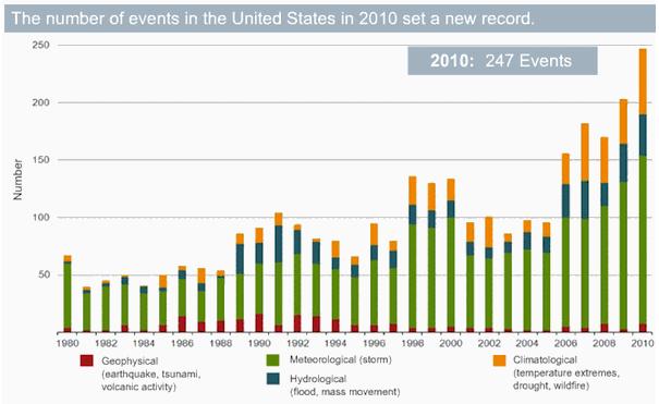
"
So in the latest 15 year period there were almost twice as many
billion dollar plus extreme weather events as in the 15 year period
preceding it..." - from a story at The San Diego Free Press; details below. AP photo: Peter Morgan.
"
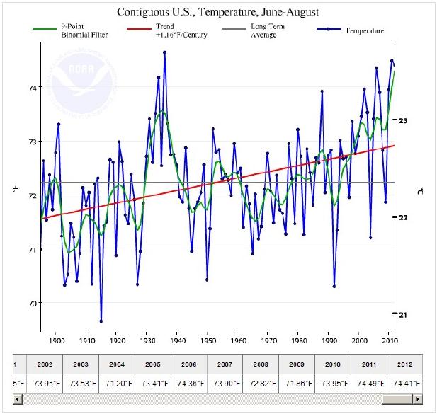
The first eight months of 2012 have gone into the books as the
warmest January-August period on record for the continental US,
according to the National Oceanic and Atmospheric Administration's National Climatic Data Center in Asheville, N.C.
The 12-month span ending in August 2012 was the warmest 12 months on
record. The summer itself ranks third among the warmest summers on
record." - from a Christian Science Monitor article; details below.
"
Only the USA has been experiencing extreme heat this year - the rest of the planet has been unusually cool." Sorry, that statement doesn't hold up. Check out global 2012 temperature trends from NASA below.
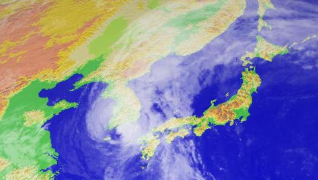
Typhoon "Sanba". As of Sunday evening Sanba was
still a Category 2 typhoon (same thing as hurricane) with sustained
winds close to 100 mph. Seoul will be brushed with 30-50 mph wind gusts
and 3-6" of rain, the core of strongest winds and heaviest rains passing
south/east of South Korea's capital city. Image:
Digital Typhoon.
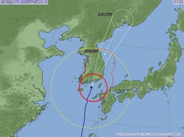
Sanba's Track. The center of the red circle marks
the location as of Sunday evening. Sanba will hit the southern/eastern
coast of Korea with winds gusting to 80-95 mph before accelerating out
to sea Monday night and Tuesday. Forecast map: Japan Meteorological
Agency.
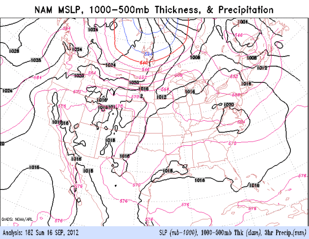
A Big Canadian Leak. The 84-hour NAM model shows a
chilly blast of air pushing east today and Tuesday, sparking a band of
heavy showers and T-storms from the Great Lakes to the east coast,
followed by a risk of frost for Michigan and northern Wisconsin Tuesday
morning. Model data: NOAA.
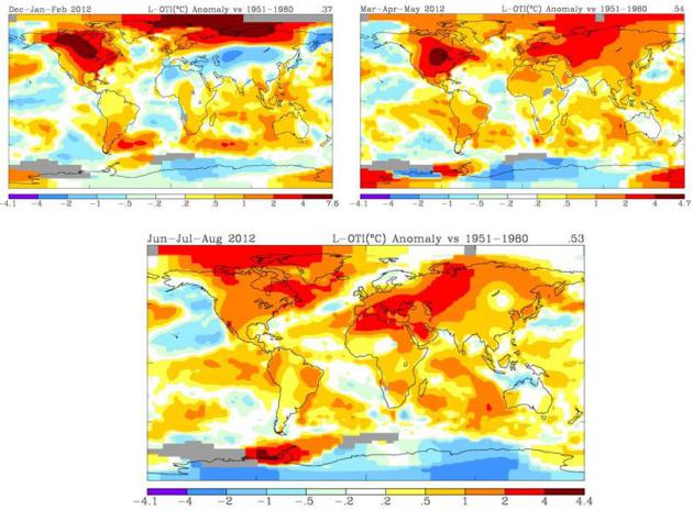
2012: Global Warming. I run into a fair number of people who tell me "
Paul, yes, the USA had a very hot summer. So what? The rest of the world has been unusually chilly so it all cancels out." Really? The global data set doesn't support that statement.
NASA data
(above) shows global temperatures anomalies since December, 2011. The
upper left graphic shows December - February temperature trends, showing
intense warming over North America and far northern latitudes, but a
cool bias for portions of Asia. Spring anomalies (upper right) show a
fairly uniform warming over most of the planet, the same with summer
anomalies (bottom map) - average summer temperatures 3-5 F. warmer than
the long-term average for Canada, North Africa and a big chunk of Asia.
The data is the data, and the maps above reflect trends seen not just
since December of 2011, but since the mid-80s.
Summer Of 2012: Just Hot Or Did We Do It? WJLA-TV
meteorologist Bob Ryan does a good job of sorting out the (global)
trends from land-use issues and "normal" variations in temperature in
this
important post; here's an excerpt: "...
The
long term trend is clear, but the year to year variability is also
clear. I deal with probabilities so I'll go out on a limb and say I
think it is unlikely next summer in Washington will be our 4th really
hot summer in a row. Then to answer the question in my title. Did "we"
make the past summer as hot as it was? I think the answer is no . . .
but we sure helped make it hotter than average and our footprints of a
warmer world, probably a warmer DC area in the coming decades are
clearer and clearer all the time. Some of my colleagues don't agree. I
look forward to their blogs on climate and if there is a human
"footprint" on our environment, climate and weather patterns."
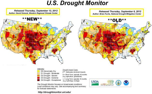
Drought of 2012: Status Quo. Not much change in the
U.S. Drought Monitor
- the driest conditions from the Midwest into the Central and Southern
Plains, a pocket of extreme/exceptional drought over eastern Alabama
and Georgia.
Blocking Patterns: How Global Warming May Have Worsened U.S. Drought.
Extreme warming over the Arctic is affecting the jet stream patterns,
with a greater tendency toward "blocks", holding patterns aloft that can
make heat, drought (and flooding) worse.
The Christian Science Monitor explains; here's an excerpt: "
As the summer of 2012 winds down, with drought and searing temperatures its hallmark for much of the continental United States,
researchers are trying to get a better handle on the factors that
contribute to the persistence of weather patterns responsible for the
extremes. The immediate culprit: patterns of atmospheric flow that
steer storms along a given path for weeks, heating and depriving some
areas of needed rain while drenching others. Such blocking patterns are
a global phenomena, a normal component of Earth's weather systems. But
some researchers suggest that global warming's influence on the Arctic
and on the tropics can change circulation patterns in ways that keep
blocking patterns in place longer than they otherwise might."
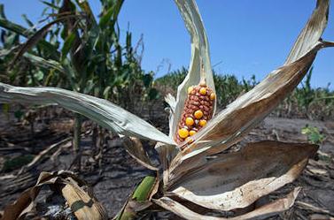
Photo credit above: "
Drought-damaged corn is seen in a field near Nickerson, Neb., on Aug. 16." Nati Harnik/AP/File
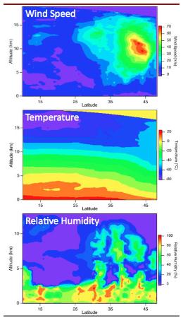
Getting The Drop On Storms. Hurricane Hunter
aircraft drop highly-sensitive weather instruments into hurricanes;
these "dropsondes" send back a real-time stream of information that
bolsters the high-resolution computer models hurricane forecasters rely
on to get a handle on these massive, Texas-size storms. Here's a great
explanation of how these instruments work in a post at
NCAR's AtmosNews: "
Whenever
NOAA’s National Hurricane Center (NHC) warns millions of coastal
residents about a potential storm, one of the tools backing up the
decision is a small and highly sophisticated instrument package
developed at NCAR. Dozens of these packages, known as dropsondes, are
released at high altitudes by “hurricane hunter” aircraft to transmit
data on temperature, pressure, humidity, and wind while descending by
parachute through tropical storms and hurricanes. Equipped with GPS
technology to pinpoint atmospheric conditions by location, the
dropsondes have led to an average 10–20% improvement in track forecasts
for the critical 48-hour window in which hurricane watches and
warnings are issued, according to the NHC. Those warnings are estimated
to save an average of about 200 lives yearly."
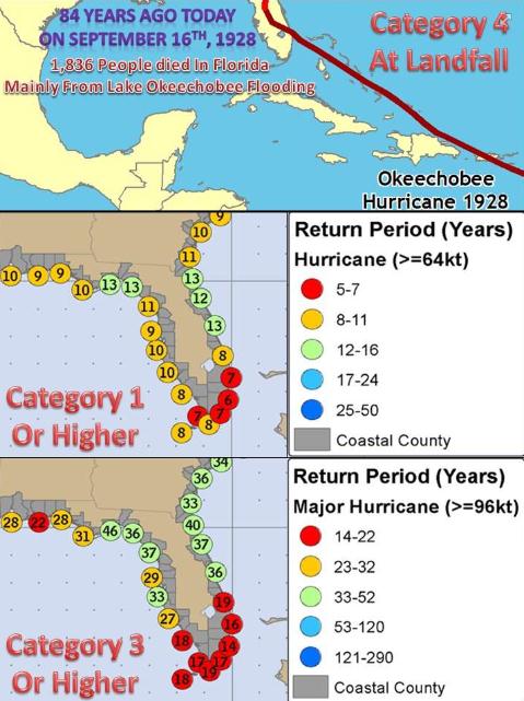 Hurricane Climatology
. The
Tampa office
of the National Weather Service has an interesting post, reminding us
of a the tragic Hurricane of 1928 (before storms had names) that claimed
nearly 2,000 lives across Florida. Other charts include the return
frequency of all hurricanes (middle) and major, Category 3+ hurricanes
(bottom). Details:
"
Florida's
deadliest hurricane struck on this date back in 1928. The "Okeechobee"
hurricane of 1928 made landfall near Palm Beach as a category 4 storm.
Over 1800 people lost their lives, mostly from a 6 to 9 foot storm
surge on Lake Okeechobee. The bottom two images show the
average return date for hurricanes and major hurricanes. On average,
Tampa Bay would see a hurricane pass within 50 nautical miles every ten
years. Tampa Bay would see a major (category 3 or higher) hurricane
pass within 50 nautical miles every 33 years. The last major hurricane
to make landfall within 50 miles of Tampa Bay was in 1921!"
"After You". I mean, what were these guys thinking?
iPhone 5: Everything You Need To Know. Did you hear, Apple just came out with a new smartphone?
Gizmodo.com does a nice job of summarizing the iPhone 5; here's an excerpt: "
The
new iPhone 5 is here. It's thinner and faster than ever, with a new
form factor that uses a gorgeous panoramic screen with more resolutions
and less consumption. It also surfs the web much faster, thanks to its
new LTE capabilities. And, just as we knew, it has a new smaller dock
connector called Lightning. Overall, it seems they have incrementally
improved every single aspect of the iPhone. It's not a revolutionary
phone, but it is a very nice release."
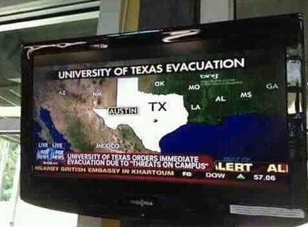
"Fair, Balanced, And Not Especially Good at Geography."
Hey, cut us a break, it was spot news and there was a new guy on Chyron
who got a little confused. It's those crazy southern states anyway. Who
cares where Missouri, Alabama and Mississippi are on a silly map
anyway. We got Texas right!
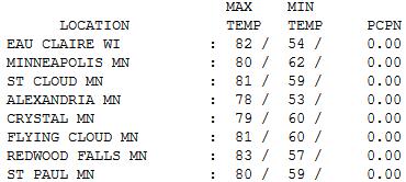
Last 80 of 2012? Probably Not. I base that on the
overall trends: this year is the warmest on record (to date) and long
range guidance is hinting at 70s and 80s the last few days of September.
But a definite correction is shaping up through at least the middle of
next week. Sunday highs ranged from 80 in the Twin Cities to 81 St.
Cloud and 83 Redwood Falls.
On This Date in Weather History (courtesy of the
Twin Cities National Weather Service):
1955: A late-season tornado hits Koochiching County. Most damage was confined to trees.
1911:
Pipestone is hit with baseball-sized hail that smashes numerous windows
at the Calumet Hotel and high school. The local observer measured hail
three inches deep. People got their photos taken in automobiles
surrounded by the icy white ground.
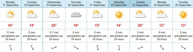
 Paul's Conservation Minnesota Outlook for the Twin Cities and all of Minnesota:
TODAY: Gusty & cooler with showers. Winds: NW 15-25. High: 59
MONDAY NIGHT: Stil raw - much colder. Low: 39
TUESDAY: Chilly start. Bright sun, breezy. High: 59
WEDNESDAY: Next clipper. Milder, patchy clouds. Low: 46. High: near 70
THURSDAY: Partly sunny, cooler. Low: 49. High: 64
FRIDAY: Mix of clouds & sun, brisk. Low: 45. High: 62
SATURDAY: Sunny start, PM clouds, cool wind. Low: 39. High: 59
SUNDAY: Fading sun, brief warm-up. Low: 43. High: 69

Why Weather?
Why weather? I'm not smart enough to be a lawyer
or doctor. I'm still mesmerized by storms; they remind me how small,
insignificant and powerless I really am.
On sunny, quiet days I can turn to my wife for that.
There's the intellectual challenge of predicting
the future, and the communications challenge: choosing the right words
to paint a picture in the mind of the reader. Great toys (um technology)
too. That, and every day is different. Weather patterns may be similar,
but never identical. Tough to get stuck in a boring rut.
Especially this year. No snow is in sight for
the metro area through the end of the month. Where else does the weather
guy have to put that down on paper in mid-September? A light frost
can't be ruled out for far outlying suburbs Tuesday morning, but right
now I don't see a widespread frost/freeze for most suburbs. It doesn't
look quite as cold as it did 24 hours ago.
A blocking pattern over Greenland keeps a family
of windblown clippers pumping chilly air into Minnesota thru early next
week. The first reality check arrives today with showers; by tomorrow
there will be NO doubt in your mind that it's meteorological autumn.
Don't write off warmth just yet: 70s, even a few 80s are possible the last few days of September.
Climate Stories...
Extreme Weather Watch: The Effects Of Global Warming Are Here Right Now. Here's an excerpt from a story at
The San Diego Free Press: "
Even
those global warming deniers can’t escape the fact that the weather
events causing a billion dollars or more of damage and destruction are
piling up at an increasing rate. The National Climatic Data Center (NCDC)
is the Nation’s Scorekeeper in terms of addressing severe
weather/climate events. The NCDC tracks and evaluates climate events in
the U.S. and globally that have great economic and societal impacts.
The U.S. has sustained 133 weather/climate disasters since 1980 where
overall damages/costs reached or exceeded $1 billion - assuming Consumer Price Index (CPI) adjustment to 2012. 46 of these events occurred between 1980 and 1995 and 87 occurred between 1996 and 2011."
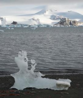
Global Warming: How Fast Will The Ice Melt? Here's a clip from a recent story at
The Summit County Citizens Voice: "
It’s
pretty clear that glaciers and ice fields have been melting the past
few decades under relentless global warming. But scientists aren’t sure
exactly how fast the melting will proceed, whether it will speed up,
or perhaps stabilize at some point. A new study looking back at historic
changes in response to climate variations may help answer some of
those questions. The research shows that glaciers on Canada’s Baffin
Island expanded rapidly during a brief cold snap about 8,200 years ago,
suggesting that changes can be sudden and drastic."
Photo credit above: "Research finds that ice sheets can be very sensitive to short-term temperature variations." Photo by Bob Berwyn.
In the Future Living In U.S. Will Be More Neighborly. I hope this extended outlook proves prescient; details from
The Detroit Free Press; here's an excerpt: "
In
the next American metropolis, people will live in smaller homes, relax
in smaller yards, park their smaller cars in smaller spots. They will
be closer to work, to play and, above all, to one another. Global
warming will be a fait accompli in 30 years, and so these urban
Americans will raise their own food, in fields and on rooftops, and
build structures to withstand everything from hurricane winds to
Formosan termites. They will walk and ride more and drive less. And they
will like it. This is the future envisioned by Andres Duany, architect,
town planner, teacher and polemicist. And the future, he will tell
you, is his business."
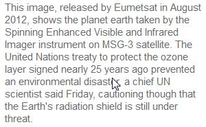
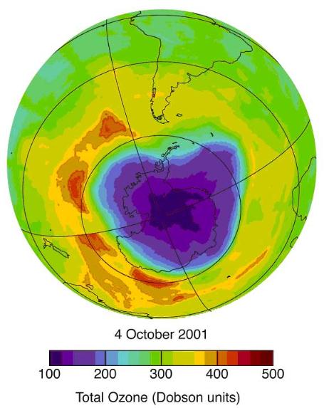
Saving The Ozone Layer: Lessons For Fighting Climate Change. Here's an excerpt of an article from NRDC and
Huffington Post: "....
Now
that CFCs have been eliminated through the Montreal Protocol, the
ozone layer has started to repair itself and to restore its capacity to
shield us from disease. Just phasing out the U.S. portion of CFCs will prevent nearly 300 million cases
of non-melanoma skin cancer in America and many more worldwide by the
year 2165. The effort to restore the ozone layer is a resounding public
health and environmental success -- one in which I am proud to say NRDC
played a central role. It is a testament to the human community's
ability to solve global problems. And it is proof we can do it faster
and cheaper than originally thought. Now it is time to apply the
lessons learned in the ozone achievement to the fight against another
planetary crisis: climate change."
Image above: NASA.
.
Fossil Fuel Industry Ads Dominate TV Campaign. Have
you noticed any commercials for "clean coal" in recent weeks? Me too.
Details on the geyser of fossil-fuel money involved in this year's
presidential campaign from
The New York Times; here's an excerpt: "
When Barack Obama first ran for president, being green was so popular that oil
companies like Chevron were boasting about their commitment to
renewable energy, and his Republican opponent, John McCain, supported
action on global warming. As Mr. Obama seeks re-election, that world is a distant memory. Some of the mightiest players in the oil, gas and coal
industries are financing an aggressive effort to defeat him, or at
least press him to adopt policies that are friendlier to fossil fuels.
And the president’s former allies in promoting wind and solar power and caps on greenhouse gases? They are disenchanted and sitting on their wallets."
Forecast The Core Facts On Climate Change. Doug Craig has had enough, and he's not mincing words in his latest "
Climate of Change" post
at redding.com. I'm not sure name-calling is the answer, although I'm
amused when people call me a "warmist" or "alarmist". The trends are in
fact, alarming. Just calling it like it is. Here's an excerpt from the
post: "
Calling the deniers by the name deniers is too kind. A
better name would be saboteurs. A saboteur is someone who engages in
sabotage. "Sabotage is a deliberate action aimed at weakening another entity through subversion, obstruction, disruption, or destruction."
The saboteurs have one aim. Delay. They pretend to participate in
this process in good faith but they cannot be trusted. Nothing they say
can be believed. They offer us nothing. They come in the name of
science but they deliberately deceive. They are the enemies of the
Earth, our children, their own children, future generations, the poor
and non-human life. They are essentially a destructive or negative force
in the world. Some of them do this consciously. They know the truth
and deliberately choose to lie. Others are simply misinformed, easily
misled or closed to new information that conflicts with their core
beliefs and values...."


No comments:
Post a Comment