64 F. high on Monday in the Twin Cities.
71 F. average high for September 17.
67 F. high on September 17, 2011.
.19" rain fell from Monday morning's cold frontal passage.
.30" rain so far this month.
1.79" average rainfall for the first 16 days of September.
 Big Swings
.
Today will be about 5-10 F. cooler than average, but still a pleasant
fall day. After warming to or above 70 Wednesday we cool off again late
in the week, a few weather models showing lows in the mid 30s Saturday
morning.
"...
Incredibly, in some areas, even in "Tornado Alley," public
shelters are closing because of manpower issues, inflexible Americans
with Disabilities Act requirements, or underfunding for emergency
management. Certainly, homes can be built more cheaply and quickly on a
slab – and for a generation now, we have built homes without
basements, resulting in homes that have greatly decreased tornado
survivability. However, basements can be built almost anywhere,
notwithstanding claims that the water table is too high. More
basements, storm cellars, and safe rooms simply must be built in more
of "tornado country." - from a post about protecting populations from tornadoes and other deadly weather risks at enterstageright.com below.
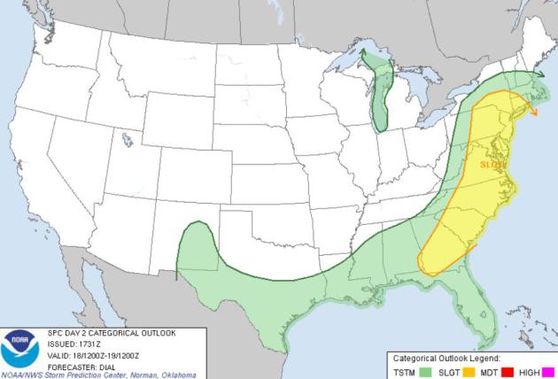 Severe Weather Outbreak
.
Conditions are ripe for a squall line with hail, straight-line winds,
even an isolated tornado for much of the east coast later today. SPC
has a slight risk from New York southward to Atlanta and Savannah.
"
The most frequently described experiences of global warming were
changes in seasons (36 per cent), weather (25 per cent), lake levels
(24 per cent), changes in plant and animal species (20 per cent) and
snowfall (19 per cent). Notably, most of these perceived signals were
indeed borne out of regional climatic records." - from a story at The Calgary Herald below.
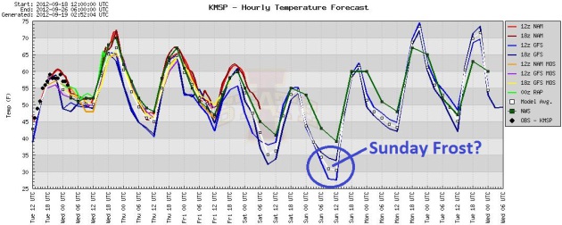
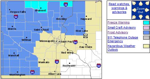
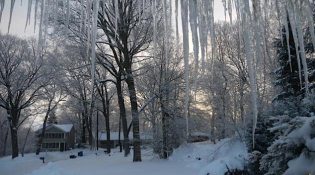
F-F-F-Freeze Warnings and Frost Advisories. No
frosty worries here in the Twin Cities metro, at least not yet - a few
outlying suburbs waking up to upper 30s. A Freeze Warning is posted for
far northern Minnesota (north of a line from Brainerd to Duluth) for a
few hours colder than 28-30, which may kill off a significant amount of
plant life (and ragweed!). A Frost Advisory is posted for Willmar, St.
Cloud and Marshall - I suspect a much closer call over the weekend,
especially Sunday morning, when even close-in suburbs of the Twin Cities
may come very close to 32 F.
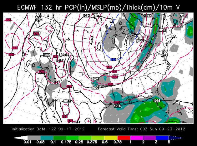
Cold Enough Aloft For Flurries (and Frost). The map
above shows the ECMWF (European) outlook for Saturday evening, a massive
wrinkle of cold air aloft hovering above the Upper Midwest and Great
lakes. Clouds will form during the day Saturday, and depending on cloud
cover the stage may be set for a frost for some Twin Cities suburbs
Saturday morning, again early Sunday. The downtowns should remain
frost-free, but from Medina to Ham Lake to Stillwater and Lakeville, I
suspect a little frost may be on the pumpkin by 7 am Sunday morning.
Map: WSI.
 Ups and Downs
. The ECMWF
(European)
model
also shows 70+ Wednesday, cooling into the low 50s by Saturday with a
few light showers (rain). Sunday looks sunnier and a bit milder, 70
returning by Monday. Nothing resembling a storm with significant rain in
sight.
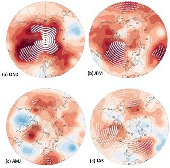
Evidence Linking Arctic Amplification To Extreme Weather In Mid-Latitudes.
This study caught my eye earlier this year, and with record melting
over the Arctic I thought it might be timely to highlight the findings
once again. The impact of a warmer Arctic (slower jet stream winds over
mid-latitudes favoring high-amplitude patterns which can cause weather
to stall for days, even weeks) tends to be most pronounced in spring and
autumn. Here's the abstract at GRL,
Geophysical Research Letters: "
Arctic
amplification (AA) – the observed enhanced warming in high northern
latitudes relative to the northern hemisphere –
is evident in lower-tropospheric temperatures and in 1000-to-500 hPa
thicknesses. Daily fields of 500 hPa heights from the
National Centers for Environmental Prediction Reanalysis are
analyzed over N. America and the N. Atlantic to assess changes
in north-south (Rossby) wave characteristics associated
with AA and the relaxation of poleward thickness gradients. Two
effects are identified that each contribute to a
slower eastward progression of Rossby waves in the upper-level flow:
1) weakened zonal winds, and 2) increased wave
amplitude. These effects are particularly evident in autumn and winter
consistent with sea-ice loss, but are also
apparent in summer, possibly related to earlier snow melt on
high-latitude land. Slower progression of
upper-level waves would cause associated weather patterns in
mid-latitudes to be more persistent, which may lead to an
increased probability of extreme weather events that result
from prolonged conditions, such as drought, flooding, cold spells,
and heat waves."
* Meteorologist Andrew Freedman at Climate Central has a
good explanation
of this paper and recent trends, how an Arctic warming twice as fast as
mid-latitudes may be impacting our weather here at home - reprinted
from earlier this year.
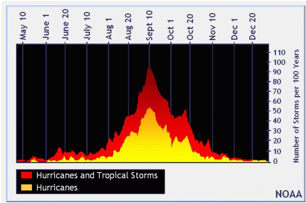
The Texas Hurricane Season Is Over. Here's an excerpt of interesting post (with some great facts and figures) from Eric Berger at
The Houston Chronicle: "
Writing
this is crazy. Preposterous, really. After all the Atlantic hurricane
season just reached its historical peak intensity last week. But you
only live once, so here goes: Hurricane season for Texas is probably,
likely, pretty much and almost certainly over. Oh, enough hedging —
it’s over people.
Let’s list the reasons.
1. Nothing appears likely to affect Texas over the next 10 days, reliable models suggest.
2. After Sept. 24, the historical odds of Texas
getting hit by a hurricane are 1-in-50, meaning it’s happened three
times in the last 150 years. So it’s rare."
* graph above courtesy of NOAA and The Houston Chronicle.
Lengthy Airline Delays In July Blamed Mostly On Storms.
Wait, wasn't there a sprawling heat wave and drought in July? Around
the edge of the heat-bubble-high there were strong to severe storms, and
they had more impact on airlines than winter storms will ever have.
Here's an excerpt from
The Los Angeles Times: "
Severe
summer storms in Chicago were blamed for most of the 18 lengthy delays
that kept passengers stuck on grounded planes in July, the U.S. Department of Transportation
reported Monday. Federal rules that took effect in 2010 prohibit
airlines from keeping passengers stranded on a grounded domestic flight
for more than three hours without allowing passengers to return to the
terminal. On international flights, the limit is four hours. Airlines
that violate the rules can be fined up to $27,500 per passenger. The
Department of Transportation is investigating 18 tarmac delays of more
than three hours for domestic flights that took place in July and one
international flight that was delayed for more than four hours."
Photo above: AP, courtesy of Owen Humphreys.
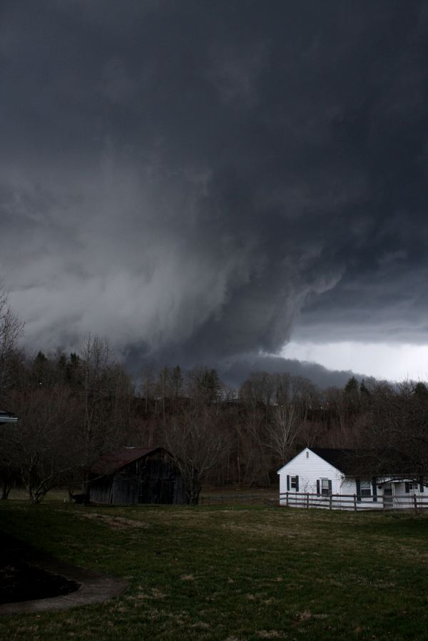
Helping At-Risk Populations Survive Tornadoes. No
matter how good the technology is, or the amount of time between when a
tornado is detected and when it arrives, you can never guarantee a happy
ending for everyone. Even with 30 minutes advanced notice a significant
percentage of the population may not have a safe place to ride out an
EF-3+ tornado. I found this to be a very insightful article from a
couple of researchers, appearing at
enterstageright.com; here's an excerpt: "...
It
is assumed that how the population utilizes this information is a
matter for emergency preparedness teams. Unfortunately, there is no
real fix for irrational human behavior. People will make bad and
sometimes deadly decisions for stupid reasons, even when they are
educated enough to know better. No NWS terminology can "cut through"
this clutter, unless a disaster arrives – and then it's too late. Just
as important, additional lead time does little for at-risk populations
that cannot evacuate and must seek "shelter-in-place." The poor, the
elderly, people with disabilities, and people without adequate shelter
(travelers and those living in mobile homes or pre-fabricated
housing) have disproportionate death rates in tornadoes. Especially
for elderly or disabled people, the alternative to
"sheltering-in-place" is being caught in a car while en route to a
shelter when the storm hits. And economically disadvantaged families
often live in substandard housing that lacks adequate shelter."
Photo above courtesy of Kent Nickell, taken near West Liberty, Kentucky.
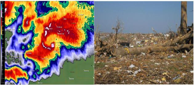
Tornado Victim's Family Names Joplin Wal-Mart In Wrong-Full Death Suit. Here's an excerpt of a story at
The Joplin Globe: "
The
family of a man killed inside the Wal-Mart Supercenter on Range Line
Road during the May 22, 2011, tornado has filed a wrongful-death
lawsuit against the Arkansas corporation and the store’s manager. Janice
Kirk and Jodelle Kirk, both of Joplin, are listed as plaintiffs in a
lawsuit that was filed July 31 in Jasper County Circuit Court and
transferred Friday to the U.S. District Court for the Western District
of Missouri. They are the wife and daughter, respectively, of Stanley
Kirk, 62, an aircraft engine technician who died as a result of injuries
suffered during the EF-5 tornado that led to the deaths of 161 people." Image credit above: NOAA.
On Our Radar: Nuclear Plants And Flood Risks. Most
nuclear plants rely on nearby rivers for cooling, which as all fine and
well until major floods threaten. Here's a clip from a
New York Times article: "
An engineer within the Nuclear Regulatory Commission accuses its regulators
of deliberately covering up information related to the vulnerability
of nuclear power plants that sit downstream from large dams and
reservoirs. [The Huffington Post] Tree deaths
from insects and diseases have plunged recently in the United States,
mainly because mountain pine beetles are running out of food, the
Forest Service says. But the next cycle of infestation is well under
way in the south-central Rockies, where spruce beetles are devastating
mature trees. [The Summit County Voice]"
Photo credit above:
Associated Press. "The Fort Calhoun nuclear plant in Nebraska in June 2011, when it was surrounded by floodwaters."
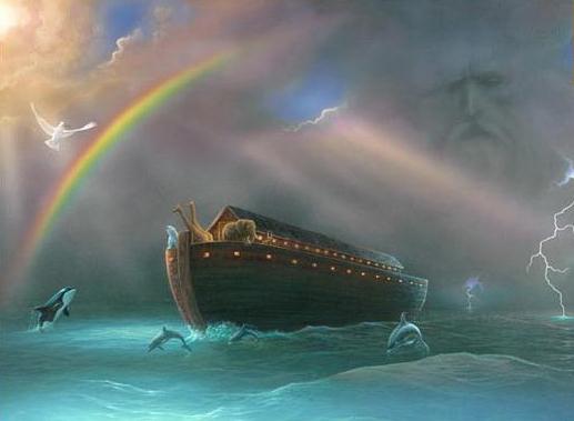
Q&A: Geologist David Montgomery On Noah's Flood. I read this book review at
The Seattle Times and it resonated - here's a quick excerpt from a longer read: "
David Montgomery
goes where most scientists might fear to tread. The University of
Washington geologist and MacArthur Fellow has written a new book,
"The Rocks Don't Lie: A Geologist Investigates Noah's Flood"
(Norton), which takes on the polarized argument between science and
some Christians over the very nature of creation. What could be more
charged than the debate between "young earth" creationists, who believe
the world was made by God less than 10,000 years ago, and geologists,
who peg the age of the Earth at about 4.54 billion years? But
Montgomery has written a thoughtful, readable book that respects both
sides." Photo:
The Peope's Forum.
BMW To Show New i3 Concept In Paris. Talk about
pushing the envelope - you may not appreciate the asthetics, but
something tells me BMW will do very well with the i3 and the beefed-up,
more elegant i8. Here's an overview from
gizmag.com: "
BMW will present a new version of its i3 Concept
electric vehicle at the Paris Motor Show later this month. This time
around, BMW is emphasizing its holistic approach to sustainability by
focusing not just on the all-electric drive-train and extensive use of
carbon fiber reinforced plastic (CFRP) to reduce weight, but on the
renewable materials employed to put the finishing touches on the
high-tech interior."
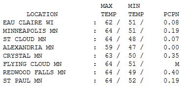 Brisk
Brisk.
So this is what autumn is supposed to feel like. After a wet start
temperatures held in the 50s most of the day, statewide with some midday
and PM sun giving way to instability clouds and sprinkles up north.
Highs ranged from 59 Alexandria to 64 St. Cloud and the Twin Cities.
On This Date In Weather History (courtesy of the
Twin Cities NWS):
1997: An F3 Tornado destroyed
several buildings and numerous others damaged. Hundreds of trees were
knocked down. A number of cattle were also killed in a barn that
collapsed. One man was injured when the tornado engulfed his car and
threw it into a nearby woods. A second man was critically injured when
his garage collapsed. He died several weeks later. The total path length
of the tornado from 1 NE of Lastrup to Onamia was 17 miles. Total
property damages were estimated at $1.7 Million. In total, 6 tornadoes
touched down in Morrison, Mille Lacs, and Kanabec.
1991: Duluth got a 2.5 inch summer snowstorm. (Fall was still five days away)
1971:
A brush fire at Lake Alexander in Morrison County started a 10-foot
wide, 50-foot high "fire whirl." It moved out over the lake, overturned a
1,800 pound pontoon boat, and then dissipated as it moved back to
shore.
1903: 3.75 inches of rain fell in the Minneapolis area.
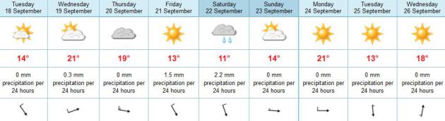
Paul's Conservation Minnesota Outlook for the Twin Cities and all of Minnesota:
TODAY: Plenty of sun, cool breeze. Winds: NW 10-15. High: 61
TUESDAY NIGHT: Clear to partly cloudy, not as chilly. Low: 47
WEDNESDAY: Milder, stray shower possible. High: 70
THURSDAY: Blue sky, a bit cooler. Low: 49. High: 66
FRIDAY: Next Alberta Clipper. Gray and gusty, few showers. Low: 47. High: 58
SATURDAY: Patchy frost outlying suburbs early? Mostly cloudy and raw, October-like. Low: 36. High: 54
SATURDAY NIGHT: Partial clearing - frost can't be ruled out, especially outer suburbs. Low: 37
SUNDAY: Sunnier, nicer day of the weekend - warming up a bit. High: 64
MONDAY: Sunny and milder. Low: 50. High: 71
* photo above courtesy of NASA.
The Big Slide
Addison Green stuck his head in my office, a
look of bemused horror on his face. One of 12 TV meteorologists on the
air here at WeatherNation, our new national channel focused on 24/7
weather, he had just flown in from his boyhood home in New York City.
"What can I expect Paul? Is it going to be as rough as everyone says?"
I scratched my jaw thoughtfully. "I have no idea" I confided. "But odds are it won't be average".
We'll either have another easy winter (courtesy
of an El Nino warm phase of the Pacific) or we'll get hammered, like 2
winters ago. I'm leaning toward the former, based on the historic warmth
of 2012, but at this point nothing would surprise me.
A Freeze Watch is posted up north this morning,
but the metro stays frost-free into Friday. On average (ha!) we enjoy
our first 32 F. low October 4, our first flurries by October 15-20; the
first 1 inch of snow greases up area highways by November 2.
A hiccup of warmth Wednesday (70F) will be
drowned out by repeated sneezes of October-like air; a stronger push of
Cool Canadian Fun arrives by the weekend. If skies clear Saturday night
we may see our first suburban frost. It'll be close.
Hang in there Addison.
Climate Stories...
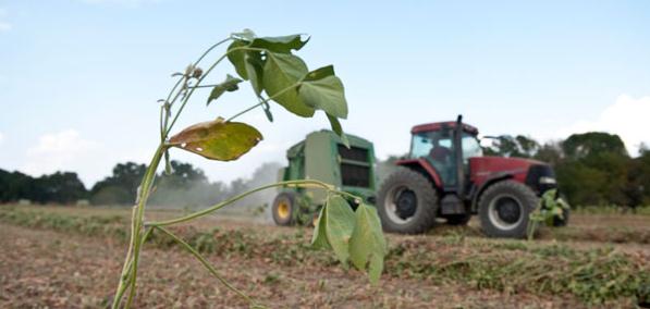
Droughts Latest Wrinkle In Climate Debate. The story from
Politico; here's an excerpt: "
Climate
change is here. Even those who differ over its cause agree that it’s
happening. In the United States alone, 28,570 high-heat records have
been set so far this year, more than ever before, the National Oceanic
and Atmospheric Administration reported this month. As if that weren’t
problem enough, the world is also plunging into another major food
crisis. And what most people don’t know is that the two issues are
directly related. Food prices “soared by 10 percent in July” alone, the
World Bank said, because of “an unprecedented summer of droughts”
worldwide. The U.S. is hardly the only nation affected, but the
Department of Agriculture said more than half of this nation’s counties
have been designated disaster zones because of the summer’s
devastating drought, including many major food producers. That has
never happened before either."
Photo credit above: "Experts said they don’t know if this food-price spike will be as severe as the one in 2008." | AP Photo
Financial Cost Of Climate Change Seriously Underestimated By U.S. Government Calculations.
Treehugger.com has the story; here's a clip: "
I'm
not really sure economic calculations play much role in how the US
government approaches climate change policy, thanks entirely to
philosophical obstructionism and corporate lobbying in Congress, but
this is nevertheless serious business: A new study in the Journal of Environmental Studies and Sciences
shows that current calculations on the future financial impacts of
climate change are being underestimated by the US government somewhere
between 2.6 and 12 times. Report co-author Laurie Johnson from NRDC
explains the full economic reasoning in two though blogs,
but the the gist of it is that the government uses a figure for the
damage caused by carbon pollution at $21 per ton of CO2, wheres a more
accurate estimate is in the range of $55-266 per ton—and that's for a
middle-of-the-road climate scenario, not worst case."
Photo credit above:
Jerry Angelica Photography/CC BY-ND 2.0
False Balance Lives: In Worst Climate Story Of The Year PBS Channels Fox News. I watched the PBS NewsHour yesterday, as I do every day, and my jaw almost hit the floor. Joe Romm at
Think Progress sums up the severe journalistic disconnect: "
If
you happened to be watching the PBS News Hour tonight, you probably
thought the show had been hijacked by Fox News. At first, their climate
segment seemed to be about Koch-funded former “skeptic” Richard Muller
and his conversion to scientific reality. But then PBS decided that the
way to “balance” a former skeptic who merely confirmed what climate
scientists have demonstrated repeatedly for decades was by quoting
nonsense from Sen. James Inhofe and then giving an extended interview
to former TV weatherman and current A-list disinformer Anthony Watts.
The video of the show itself isn’t online yet, but I’ll post it when it
is. It should forever kill the absurd notion that false balance is
dead — or that the News Hour has some sort of liberal bias. Not that
this is news — see the CP post from May, “False Balance On Climate Change at PBS NewsHour.”
Climate Change Threat More Real To Those With Perceived Personal Experience: Study. Some interesting data points in this story from
The Calgary Herald; here's an excerpt: "
We
have dramatically shrinking glaciers. We have freight trains of
science. We have adorable polar bears treading water. But wouldn’t you
know it, what really makes us fret over climate change is making it all
about us. A new study finds that a feeling of “personally
experiencing” global warming heightens people’s perception of risks
related to the environmental phenomenon – and particularly those risks
germane to where they live. Changes to the seasons, unusual weather,
water levels, snowfall patterns and shifts related to plants and animals
were among the most common signs cited by laypeople."
Deniers Lose. Freedom Of Thought Wins. The Koch Brothers Have No Right To Read Your Mail. Peter Sinclair has the latest at
Climate Crocks: "
A rare-as-hens-teeth-these-days win for freedom of thought, science, truth, justice and the American way. Deniers 0, Smart people, 1. For this week anyway – but then its only monday. Mike Mann’s Facebook Announcement:
Breaking: A victory for science! ATI loses ATI/UVa FOIA case. Judge
issues final order. Affirms the university’s right to withhold
scholarly communications and finds that the documents & personal
emails of mine demanded by ATI were indeed protected as the university
had contended."
 Court Rules for University of Virginia and Michael Mann Against Denialist Inquisition: Scholarly E-Mail and Documents are Protected Communication
.
Here's a good summary of what the courts did in response to a demand
for climate scientist Michael Mann's e-mail correspondence while doing
research at UVA from
Climate Science Watch: "
A Virginia court has affirmed the University of Virginia's right to
withhold confidential scholarly communications, thus ruling against the
global warming denialist American Tradition Institute's demand to make
public climate scientist Michael Mann's documents and email
correspondence with dozens of other scientists during his time at UVa.
This is an important victory in a case that threatened to send a
chilling message to university scholars that they could no longer to
expect to engage in personal communications without having the whole
world reading over their shoulders."


No comments:
Post a Comment