71 F. at 4:40 pm Sunday afternoon. Did you notice
your neighbors in a zombie-like trance, raking the same section of
leaves for 6 hours without a break? Not bad at all for late October. And
no, of course it can't linger (beyond Wednesday).
55 F. average high for October 21.
.27" rain predicted for the metro area by Thursday morning (00z NAM model).
35-42 F. highs return by next weekend. Enjoy 3 more days of 60s and low 70s!
Lukewarm Into Midweek. Expect 60s into midweek, even
a shot at low 70s Wednesday. Not bad considering the sun is as high in
the sky as it was the third week of February. Soak it up, because it'll
feel like November by the weekend.
East Coast Tropical Storm or Hurricane? It sounds
unlikely, yes, but during the last 2 years I've seen many things I never
thought I'd see on a weather map. It's still early, but an "October
Surprise" may be brewing for D.C, Philadelphia, and New York by next
Sunday. Details below.
Deer-Hunting Opener Outlook? No, it won't be this
mild the first weekend of November, in fact there's a good chance highs
will be in the 30s and low 40s with a chance of snow flurries and snow
showers, maybe a dusting or coating of slush up north for tracking.
Details below.
"...
Their paper, “The Republicans Should Pray for Rain: Weather,
Turnout, and Voting in U.S. Presidential Elections” confirmed the
conventional wisdom that weather does affect voter turnout, bad weather
benefits Republicans and most interestingly, two presidential
elections in the last 60 years may have had different results had the
weather been different..." - excerpt from a story focused on the
impact of weather on presidential elections over the years, details
and links below. Image above:
venturebeat.com.
The Human Touch
We're good at communicating, but really
connecting? For all the e-mails, tweets, texts and tags, there's still
no substitute for face to face.
I see it every day. We launched a high-tech
alerting system for companies, but the most popular feature?
Meteorological briefings. Simple phone calls. Talking to a human being!
It's in our DNA to prefer face-to-face interaction, hand shakes, looking people in the eye. Few deals are ever closed via Skype.
Then again, it's a good thing meteorologists
hide behind the glass of your plasma TV, so we can't hear what you
REALLY think of the weather.
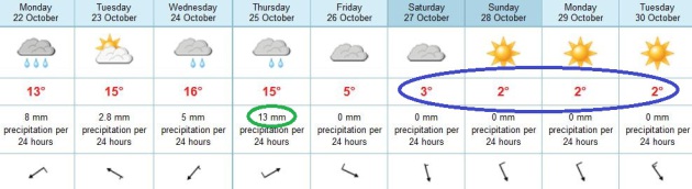
Few complaints thru midweek; highs in the 60s - 70s possible Wednesday.
Drought is overshadowing everything now. Storms
appear on computer maps, only to disappear, like meteorological mirages,
days later. Light rain falls today; a T-shower Wednesday giving way to
steadier rain Wednesday night into Thursday, but once again the heaviest
amounts stay west of MSP.
And then it cools down, rather dramatically.
Highs hold near 40 next weekend - blue sky here, but heavy snow bands
setting up over the Great Lakes.
October surprise? Many of our weather models are
hinting that a hurricane or tropical storm may hit the east coast next
weekend. Huh? Details below.

In Constant Digital Contact, We Feel "Alone Together". Following up on my brief thoughts above, I wanted to include this thoughtful article from
NPR, which shows the disconnect that digital communication can have on all of us; here's an excerpt: "...
When
Turkle asked teens and adults why they preferred text messaging over
face-to-face conversation, they responded that when you're face to
face, "you can't control what you are going to say, and you don't know
how long it's going to take or where it could go." But Turkle believes
that these perceived weaknesses of conversation are actually
conversation's strengths. Face-to-face interaction teaches "skills of
negotiation, of reading each other's emotion, of having to face the
complexity of confrontation, dealing with complex emotion," Turkle says.
She thinks people who feel they are too busy to have conversations in
person are not making the important emotional connections they
otherwise would. All this leads to Turkle's theory that it is possible
to be in constant digital communication and yet still feel very much
alone..."
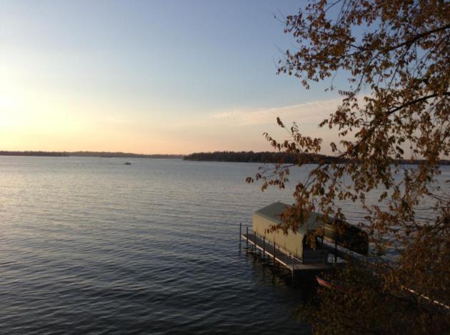
A 7 Month Boating Season. Where Am I Living Again?
Is this really Minnesota? Impossible. There were (a few) boats in the
water the very end of March, and there were boats on the lake yesterday.
I counted (on my fingers, just to be accurate and thorough) 7 months of
boating in 2012. Like you might expect to find in Washington D.C. or
maybe Memphis. How is that possible?
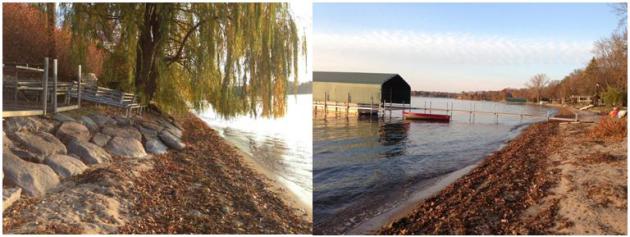
Less Water - More Shoreline. On 'Tonka water levels
are down about 2 feet, but more than 3 feet lower than last summer.
Normally the water is lapping near the top of the rocks in the upper
left. Not this autumn...
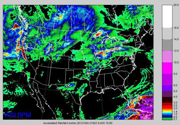
72 Hour Precipitation. WSI's high-resolution RPM
model hints at some .25 to .50" rainfall amounts for southeastern
Minnesota by Wednesday morning, some 1-2" amounts from Rockford to
Chicago and Detroil, with soaking rains for Cuba and the Bahamas as a
potential tropical storm forms in the Caribbean.
A Wetter Week. Not sure if it's real or yet another
meteorological mirage. Models print out about .20 to .25" rain later
today and tonight, a break on Tuesday, then a few T-showers late
Wednesday, followed by heavier, steadier rain Thursday as much colder
air arrives. Graph: Iowa State.
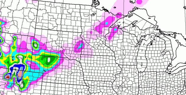
Thursday Slush Up North?
It's getting closer. The GFS prints out an inch of slush from Brainerd
to Hibbing Thursday as a cold rain (possibly) ends as a little wet snow.
Over a foot of snow is predicted for the mountains of Colorado, with
some plowable amounts into western Nebraska. Not sure I'm ready for
this...
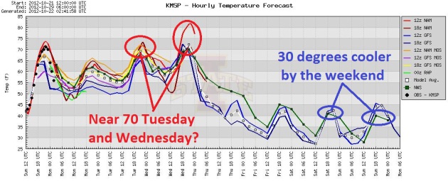
Temperature Tumble.
We should see 60s the next 3 days, into Wednesday. If skies brighten 70
isn't out of the question from MSP to the Iowa border Tuesday and
Wednesday. And then it cools off rather dramatically, highs forecast to
be near 40 by the weekend.
Something For The Entire Family.
The ECMWF solution (above) shows light rain, fog and drizzle today, a
chance of thunder Wednesday afternoon, a cold rain Thursday (possibly
the most rain all week), followed by an outbreak of heavy jackets by the
weekend, with highs holding in the 30s to near 40.
One More Tropical Storm or Hurricane in the Atlantic?
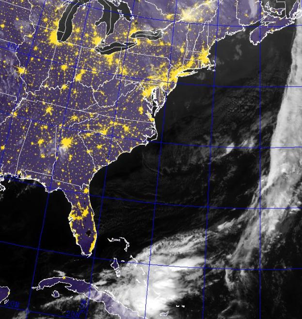
Tropical Depression.
The Sunday evening infrared satellite image from the Naval Research Lab
shows an area of heavy showers and T-storms pushing across Cuba into
the Bahamas. According to
NHC there is a 70% probability this disturbance will strengthen to tropical storm status. Lovely.
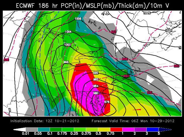
Worst Case Scenario.
The 186 hour ECMWF model brings a tropical storm or possible hurricane
into the Chesapeake Bay Sunday or Sunday night, with torrential rains
inland, turning to heavy wet snow over the Great Lakes. Far-fetched?
Let's hope so. Not buying it yet, but in the spirit of full
disclosure...
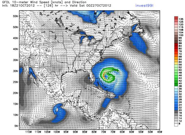
GFDL Solution.
The high-resolution hurricane model from NOAA NHC (one of many) shows a
hurricane south of Bermuda by Friday evening. The GFS solution tries to
sweep it out to sea, but ECMWF and a few other models absorb "
Sandy"
into a deep area of low pressure approaching the east coast, nudging it
inland by next weekend. It's still too early to tell with any level of
confidence.
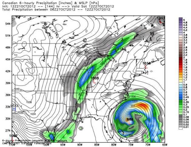
Canadian Solution.
The GEMS model shows a (very intense) hurricane off the Carolina coast
by 7 am Saturday morning. Let's hope this solution doesn't verify
either. Why do I sense a long week on the way?
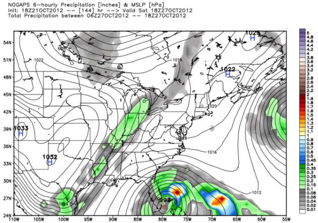
NOGAPS Model.
Just to show you how frustrating long-range forecasting can be
(especially hurricane tracks) here is the Navy's NOGAPS solution, valid
Saturday at 1 pm, showing a tropical storm or minimal hurricane pushing
into south Florida. Place your bets!
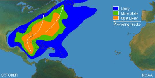
October Hurricane Climatology. The potential track of “Sandy” is
fairly typical for late October. The map above shows the most likely
tracks for October storms, from the Gulf and Caribbean into the
Carolinas before turning out to sea.
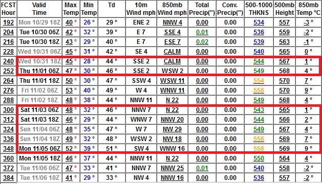
A Seasonably Cool Deer Hunting Firearms Opener. The
GFS model data (below) hints at 40s up north, maybe 50 in the metro the
first weekend of November, at or just a few degrees cooler than normal.
Right now I can't promise fresh snow up north for tracking. Nothing new
there...
Rolling Dice. Please don't put much stock in the
16-day GFS numbers. I'm including them here to pass the time, a pleasant
(?) diversion or distraction from having to do real work. Yes, it'll
change over time as new (higher resolution) data arrives. But right now
the Halloween forecast calls for upper 40s to near 50 (probaby dry).
Weather for the Deer Hunting Opener the first weekend of November looks
comparable, mid 40s to low 50s. Right now the GFS does not print out
major storms (of any flavor) from late October into the first week of
November.
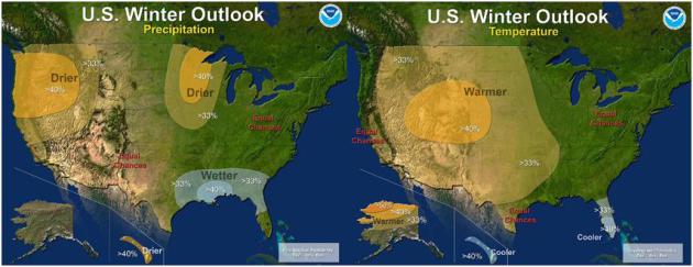
Elusive El Nino Challenges NOAA's 2012 U.S. Winter Outlook.
The on-again, off-again El Nino warming of Pacific Ocean water is
looking shaky, the odds now close to 50/50, basically a coin-flip. So
NOAA has tweaked the winter outlook from December thru February - here's an excerpt of a longer explanation: "
The
western half of the continental U.S. and central and northern Alaska
could be in for a warmer-than-average winter, while most of Florida
might be colder-than-normal December through February, according to
NOAA’s annual Winter Outlook announced today from the agency’s new
Center for Weather and Climate Prediction in College Park, Md.
Forecasters with NOAA’s Climate Prediction Center say a wavering El
Niño, expected to have developed by now, makes this year’s winter
outlook less certain than previous years.
“This is one of the most challenging outlooks we’ve
produced in recent years because El Niño decided not to show up as
expected,” said Mike Halpert, deputy director of NOAA’s Climate
Prediction Center. “In fact, it stalled out last month, leaving
neutral conditions in place in the tropical Pacific.” When El Niño is
present, warmer ocean water in the equatorial Pacific shifts the
patterns of tropical rainfall that in turn influence the strength and
position of the jetstream and storms over the Pacific Ocean and
United States. This climate pattern gives seasonal forecasters
confidence in how the U.S. winter will unfold. An El Niño watch
remains in effect because there’s still a window for it to emerge..."
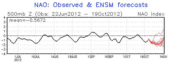
Meteorological Mirage or Reality: Heading Into a Stormier Pattern? When the
NAO
(North Atlantic Oscillation), a measure of the capacity for the
atmosphere to become stuck in a blocking pattern, goes negative, odds of
significant storms tend to rise, especially east of the Mississippi. A
strongly negative signal in late October and early November may signal
a better chance of Gulf moisture reaching Minnesota. I hope it's not
wishful thinking.
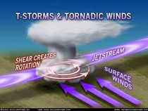
In Spite of Severe 2011, No Evidence That Tornadoes Are Getting Worse.
There's an uptick in small, brief tornadoes, possibly due to better
detection (Doppler) and more spotters out in the field looking for them,
but according to this
USA Today article, there is no evidence that major/severe tornadoes are on the rise, nationwide.
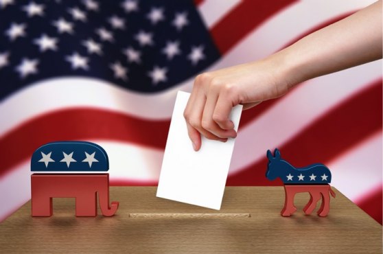
Why Republicans Should "Pray For Rain". Here is the summary of a 2005 paper (pdf here); political science researchers conclude: "
The
relationship between bad weather and lower levels of voter turnout is
widely espoused by media, political practitioners, and, perhaps, even
political scientists. Yet, there is virtually no solid empirical
evidence linking weather to voter participation. This paper provides an
extensive test of the claim.We examine the effect of weather on voter
turnout in 14 U.S. presidential elections. Using GIS interpolations, we
employ meteorological data drawn from over 22,000 U.S. weather stations
to provide election day estimates of rain and snow for each U.S.
county. We find that, when compared to normal conditions, rain
significantly reduces voter participation by a rate of just less than
1% per inch, while an inch of snowfall decreases turnout by almost .5%.
Poor weather is also shown to benefit the Republican party’s vote
share. Indeed, the weather may have contributed to two Electoral
College outcomes, the 1960 and 2000 presidential elections."
Could A Hurricane Ever Strike Southern California?
With warming oceans the idea isn't as far-fetched as it might sound at
first blush. Tropical storms have struck San Diego and L.A. before, a
long time ago, so the odds aren't zero, but California residents
probably shouldn't lose much sleep over this. Here's an excerpt of a
NASA JPL story: "
There's
an old adage (with several variations) that California has four
seasons: earthquake, fire, flood and drought. While Californians
happily cede the title of Hurricane Capital of America to U.S. East and
Gulf coasters, every once in a while, Mother Nature sends a reminder
to Southern Californians that they are not completely immune to the
whims of tropical cyclones. Typically, this takes the form of rainfall
from the remnants of a tropical cyclone in the eastern Pacific, as
happened recently when the remnants of Hurricane John brought rain and
thunderstorms to parts of Southern California. But could a hurricane
ever make landfall in Southern California? The answer, as it turns
out, is yes, and no. While there has never been a documented case of a
hurricane making landfall in California, the Golden State has had its
share of run-ins and close calls with tropical cyclones. In fact,
California has been affected by at least a few tropical cyclones in
every decade since 1900. Over that timeframe, three of those storms
brought gale-force winds to California: an unnamed California tropical
storm in 1939, Kathleen in 1976 and Nora in 1997. But the primary
threat from California tropical cyclones isn't winds or storm surge.
It's rainfall -- sometimes torrential -- which has led to flooding,
damage and, occasionally, casualties..."
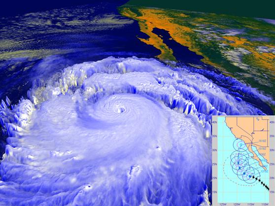
Image credit above: "
In September 1997, powerful Hurricane
Linda, shown in this NASA rendering created with data from the NOAA
GOES-9 satellite, was briefly forecast to strike Southern California,
most likely as a tropical storm, as shown in the inset forecast track
from the Naval Research Laboratory’s Marine Meteorology Division. The
storm eventually turned westward away from land, but still brought
rainfall to parts of Southern California and high surf." Image credit: NASA/NOAA/NRL
TV Viewers "Left In The Dark" About Flood Of Political Ads.
As one political scientist explained to me "other countries give
candidates free airtime. But not the USA, where stations and networks
that take advantage of (free) spectrum, spectrum that belongs to
everyone, and is
licensed to broadcasters with the charge that
they "serve the public interest", CHARGE politicians for the priviledge
of reaching viewers over our nation's airwaves. The result is a
money-treadmill that would make the Founding Fathers turn over in their
graves. Candidates spend much of their time, not legislating, but
raising money to fund negative attack-ads on television. The entire
system is out of whack."
Maybe so. Here's an excerpt from
Free Press: "
On Monday, Free Press released Left in the Dark,
an analysis of political advertising and local news coverage in five
cities — Charlotte, Cleveland, Las Vegas, Milwaukee and Tampa — where ad
spending has skyrocketed this year. With fewer than 45 days left until
Election Day, Americans across the country are facing an unprecedented
increase in political advertising on local stations. Media analysts
project that $3.3 billion — money that pads the bank accounts of
station owners — will be spent on television ads by Nov. 6. Left in the
Dark investigates whether stations airing political ads are balancing
out their often deceptive messages with local coverage of the role this
money is playing in the 2012 elections..."
* cartoon: Richmond Times Dispatch.
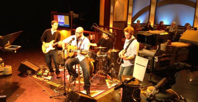
"The Lost Wheels" on TPT Almanac. If you missed the live show Friday evening on KTCA, Channel 2, you can watch the replay
here.
I babbled on about the drought, but the highlight of the show (for
dear old dad) was seeing my oldest son play lead guitar for an up and
coming Twin Cities band. Am I a little biased? Yep, but I know good
music when I hear it. You can hear some of the tracks on their new CD,
"Chipper" at their
home page. Hey, I'm hoping Walt supports me in my old age. Stranger things have happened...
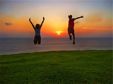
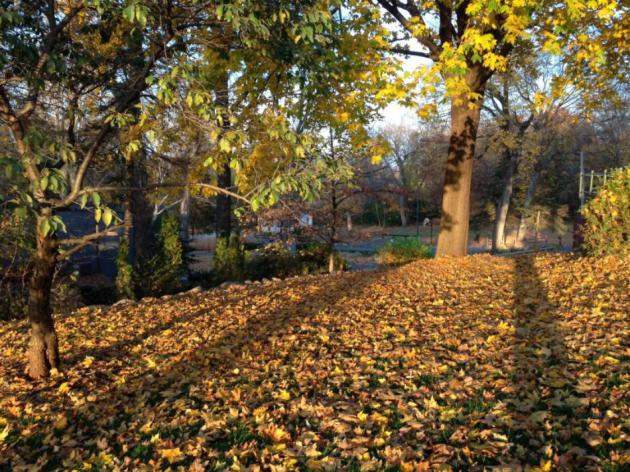
Sublime. No, it doesn't get any better than this in
late October, at least not in Minnesota. It was an atmospheric daydream
come to life, blue sky, light breezes, low humidity, and temperatures 15
degrees warmer than average. Highs ranged from 48 at Grand Marais to 65
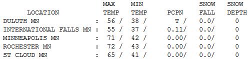
St. Cloud, 71 Twin Cities and 72 at Rochester.
Long Shadows. 71 F. on October 21? Impressive when
you consider that yesterday the sun was as high in the sky as it was on
February 21. Note to self: I really should rake those leaves...
Paul's Conservation Minnesota Outlook for the Twin Cities and all of Minnesota
TODAY: Dry start - clouds increase. A little light rain by afternoon. Winds: East 8-13. High: 62
MONDAY NIGHT: A period of light rain, patchy fog. Low: 55
TUESDAY: Mostly cloudy, still mild - passing shower north. High: 67
WEDNESDAY: Bright sun, late-day thunder? Mild. Low: 58. High: 72
THURSDAY: Heavier rain possible, cold wind. Low: 50. High: 53
FRIDAY: Partly sunny and brisk. Low: 34. High: 48
SATURDAY: Mix of clouds and sun, chilly. Low: 32. HIgh: 43
SUNDAY: Blue sky - heavy jackets. Low: 28. High: 42
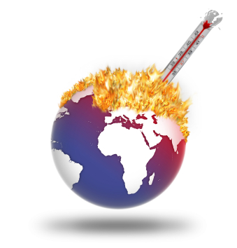
Climate Stories...

Targeting Solar Geoengineering To Minimize Risk And Inequality.
Science Codex
has the story; here's the introduction: "By tailoring geoengineering
efforts by region and by need, a new model promises to maximize the
effectiveness of solar radiation management while mitigating its
potential side effects and risks. Developed by a team of leading
researchers, the study was published in the November issue of
Nature Climate Change.
Solar geoengineering, the goal of which is to offset the global
warming caused by greenhouse gases, involves reflecting sunlight back
into space. By increasing the concentrations of aerosols in the
stratosphere or by creating low-altitude marine clouds, the as-yet
hypothetical solar geoengineering projects would scatter incoming solar
heat away from the Earth's surface. Critics of geoengineering have long
warned that such a global intervention would have unequal effects
around the world and could result in unforeseen consequences. They
argue that the potential gains may not be worth the risk..."

The Print Media And Climate Change. Here's the conclusion to a post from Doug Craig at redding.com's "
Climate of Change": "...
Back in 2000, McCright and Dunlap
examined "what they termed a 'conservative countermovement' to
undermine climate change policy, (as) they explored its organization
within right-wing think tanks, (and looked) first at its claims-making
activities and then its organization and tactics. They highlighted the
way such groups draw on scientific 'experts' linked to fossil fuel
industries and concluded that 'our
nation's failure to enact a significant climate policy is heavily
influenced by the success of the conservative movement in challenging
the legitimacy of global warming as a social problem.'" We
have no intention of solving the climate crisis. Neither presidential
candidate has uttered a word related to the topic in the two debates.
And even more telling, the American media establishment is perfectly
content to avoid the topic entirely. We know the laws of physics
require that the climate continue to warm in response to our
cataclysmic production of emissions, but the laws of politics and media
require that we pretend this is not happening."
One Mother's Reaction To The Climate Science: "I'm As Angry As Hell And High Water". Think Progress has the story; here's an excerpt: "
Over
here at Moms Clean Air Force, I’ve been–I’ll admit it–profoundly
depressed that the candidates have blown their chance to talk about the
most important issue facing our planet. Climate Change. Two debates
down. A moderator who says “Whoops! Ran out of time to ask about
climate. So sorry!” Well, I’m sorry too. And I’m angry. Angry as hell
and high water. Two debates about “domestic policy” and not one word has
been uttered about the chaotic domestic weather we’ve been enduring.
Not one word about our unreliable climate. Not one word about the pain
and suffering visited upon millions of Americans because of runaway
greenhouse gas pollution. Not one word about the ugly legacy we will
leave our children...."
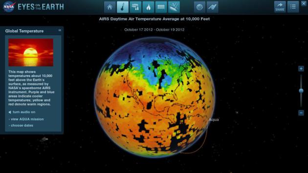
Eyes On The Earth.
NASA
has impressive on-line tools to be able visualize Earth's morphing
climate, including real-time global tracking of carbon dioxide and
carbon monoxide (showing huge plumes of pollutants sweeping across China
into the Pacific). The map above shows global temperatures from
Friday. By downloading a JAVA applet you can manipulate all these data
sets in 3-D. Very cool.
Why The Chill On Climate Change? Here's an excerpt of a thoughtful (on the money) Op-Ed at
The Washington Post: "...
Why
does it matter that nobody is talking about climate change? Because
if you accept that climate scientists are right about the warming of
the atmosphere — as Obama does, and Romney basically seems to as well —
then you understand that some big decisions will have to be made. You
also understand that while there are some measures the United States
could take unilaterally, carbon dioxide can never be controlled
without the cooperation of other big emitters such as China, India and
Brazil. You understand that this is an issue with complicated
implications for global prosperity and security. A presidential
campaign offers an opportunity to educate and engage the American
people in the decisions that climate change will force us to make.
Unfortunately, Obama and Romney have chosen to see this more as an
opportunity to pretend that the light at the end of the tunnel is not
an approaching train."
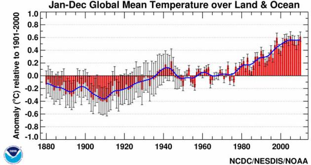
Climate Change: Journalism's Never-Ending Fight For Facts. Here's an excerpt of a story at
The Guardian's Environment Blog: "
The debate about climate change
is dogged – possibly even defined – by its interminable, intractable
tug of war over the "facts". A hand grenade is lobbed into no-man's
land triggering a volley of return fire. But, when the dust settles,
can anyone truly claim to have advanced their position? Of course, the
art of "manufacturing doubt"
has long been in the playbook of those hoping or needing to divert
attention away from evidence. We saw it a generation ago with smoking,
just as we see it today with climate change. But knowing how this
blatant tactic is deployed doesn't make it any easier to nullify or
deter. Compounding the problem is the speed at which "facts" can now
spread unchallenged across the internet. Rebutting or contextualising
inaccuracies takes expertise and, above all, time and energy..." Graphic above: NOAA NCDC.
The Sad History Of Climate Policy, According to David Brooks. Here's a clip from an important Ezra Klein Op-Ed at
The Washington Post's Wonkblog: "...
So,
to summarize: Addressing climate change by pricing carbon — an idea
Brooks supported then and supports now — was a bipartisan project in
2003. It became a partisan project because Al Gore thought it was
important enough to make a documentary about. Republicans began opposing
efforts to price carbon, in part because they hate Al Gore. That left
funding renewables research as the only avenue for those worried
about climate change. Funding renewables research means funding some
projects that won’t work out, and some that might make Al Gore rich.
This led to bad publicity that tarnished the whole program. The
passivity of Brooks’s conclusion is astonishing. This isn’t a story of
overreach, misjudgements, and disappointment. It’s a story of
Republicans putting raw partisanship and a dislike for Al Gore in front
of the planet’s best interests. It’s a story, though Brooks doesn’t
mention this, of conservatives building an alternative reality in which
the science is unsettled, and no one really knows whether the planet
is warming and, even if it is, whether humans have anything to do with
it. It’s a story of Democrats being forced into a second and
third-best policies that Republicans then use to press their political
advantage..."
Photo credit: "
Sorry, planet. You never should have let Al Gore make that documentary." (Joel Boh — Reuters)
* the David Brooks Op-Ed at The New York Times is
here. Subscription may be required.


No comments:
Post a Comment