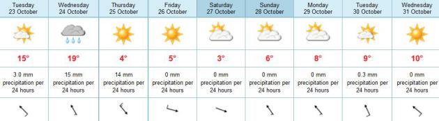
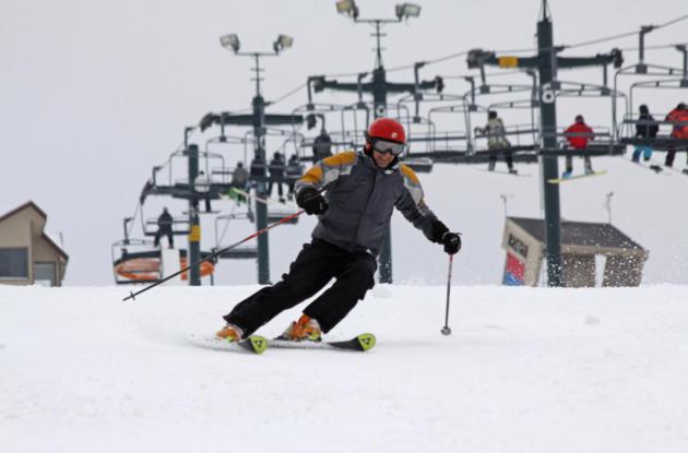
64 F. high in the Twin Cities Monday.
55 F. average high on October 22.
61 F. high on October 22, 2011.
Today: mildest day in sight - if skies brighten 70 is possible later today.
30 degrees colder by Friday.
October Surprise? It's still (very) early, but the
fairly reliable ECMWF model raises the distinct possibility of a
hurricane hitting coastal New England by Halloween of next week.
Residents of the east coast should pay attention. Details below.
Wet Halloween - Dry, 50-Degree Hunting Opener? The
extended forecast is below, potentially scary weather (soggy with a cold
rain) on October 31, but temperatures may mellow a bit for the first
weekend of November. Pumpkin photo:
lolpranks.com.
"...
As the World Bank’s World Development Report 2010 argues,
“Economic growth alone is unlikely to be fast or equitable enough to
counter threats from climate change, particularly if it remains carbon
intensive and accelerates global warming.” The World Bank goes on to
say, “climate policy cannot be framed as a choice between growth and
climate change. In fact, climate-smart policies are those that enhance
development, reduce vulnerability, and finance the transition to
low-carbon growth paths...” - from a Think Progress post on pro-business climate policies. Details below.
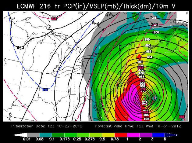
Halloween Hurricane?
Late October can be a harrowing time to be a
meteorologist. Huge north-south temperature extremes can brew up massive
storms. Exhibit A: Halloween Superstorm of 1991, which dumped nearly 30
inches of snow on MSP. The storm stalled, because "The Perfect Storm"
stalled off the coast of New England. None of the computer models picked
it up.
Two big weather stories today: a November-like
slap is shaping up later this week; a cold rain Thursday may end as a
little slushy snow up north.
The other story that has me pacing: a potential
hurricane landfall for the east coast within 8 days.
What? Late October
hurricanes are rare, but not impossible; water temperatures still
abnormally warm after 2012's record summer heat. The fairly reliable
ECMWF (European) model brings a hurricane into New England on Halloween.
Talk about an unpleasant "October Surprise". The truth: it's too early
to know with any confidence, but check the blog for frequent updates.
Showers give way to a mild south breeze today; a
shot at 70 F. Wednesday may be just as mild with a few PM showers, even
a clap or two of thunder.
Heavier, steadier rain arrives Thursday AM (.5
to 1 inch possible), heralding the arrival of a REAL cold front. Dig out
the heavy jackets for next weekend.
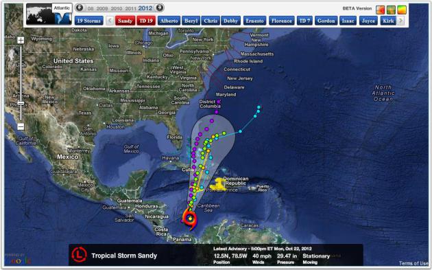
Here we go!
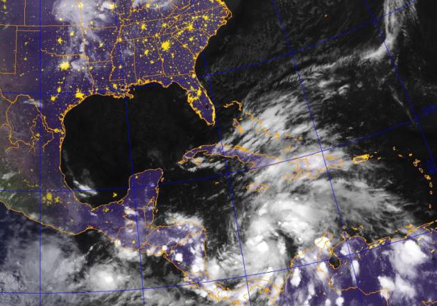
Tropical Storm Sandy. As of Monday night Sandy's
circulation was getting better organized, a lack of wind shear coupled
with unusually warm sea surface temperatures providing a ripe
environment for strengthening. Here's more on this growing tropical
storm from
NHC. Image above courtesy of the Naval Research Lab.
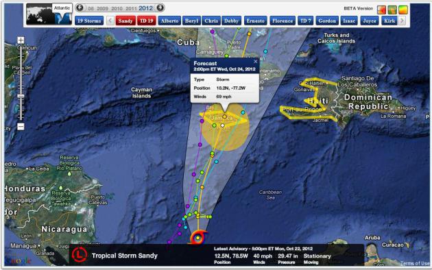
“Sandy” Hits Jamaica As Tropical Storm. Models show Sandy
hitting Jamaica as a strong tropical storm Wednesday, with sustained
winds of 65-70 mph, hurricane-force gusts over 80 mph. Map: NHC and Ham
Weather.
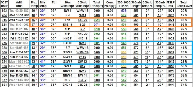
New England Landfall Next Week? It’s early, and the track will
change over time, as new data refines and improves computer model
accuracy. But we’ve had a few runs/row with the ECMWF model pulling
“Sandy” close to the coast, with landfall possible near Providence or
Boston by Wednesday of next week. If this forecast verifies, still a big
if, it will be a very rough Halloween for New England.
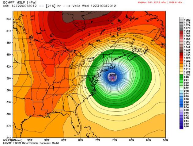
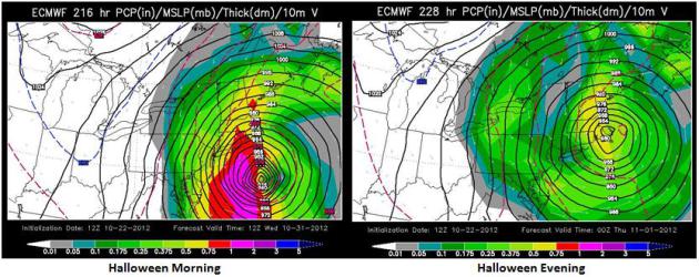
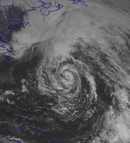
Continuity. As meteorologists, our comfort level rises when
the weather models agree. Such is the case above, the Canadian forecast
(upper left) and the NOGAPS (Navy) model (upper right) both valid Sunday
morning at 7 am – showing a MAJOR Hurricane Sandy east of North
Carolina, with hurricane-force winds and extensive beach erosion and
coastal flooding possible from the Carolinas into the Tidewater of
Virginia.
Much of Caribbean Spared. Sandy will produce serious flash
flooding for Jamaica, Cuba and the Bahamas, as well as Haiti, but Puerto
Rico and other island nations should avoid the worst of the storm. All
the models track Sandy due north. Some models whisk the growing
hurricane into the Atlantic, and there’s a 40-45% chance this could
still happen. But some of the more reliable models show Sandy much
closer to the east coast of the USA.
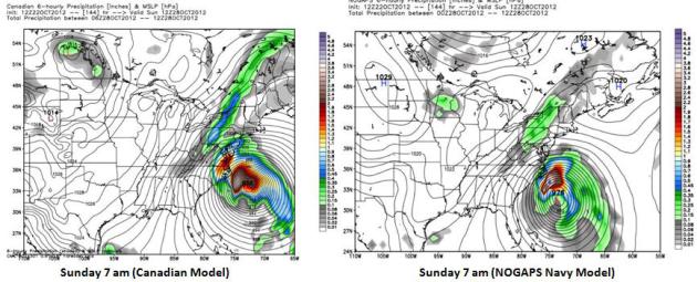
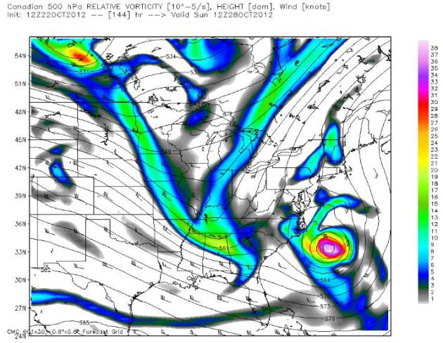
Complicating Factors. The Canadian GEMS model, valid
Sunday morning at 7 am, shows "Sandy" being pulled into a large and
deepening trough of low pressure approaching the east coast. Normally
hurricanes would veer quickly out to sea. This may not be a normal late
October hurricane scenario. Map above shows predicted Sunday winds at
500 mb, roughly 18,000 feet above the ground.
Similarities To Hurricane Grace? The remains of
"Grace", which formed in late October, 1991, eventually got sucked into
an extratropical low pressure system, mutating into a nearly stationary
super-storm that became "The Perfect Storm" - the storm that proved to
be the inspiration for the book and the movie. How quickly "Sandy" will
weaken as it pushes north remains to be seen, whether it's even possible
to push into New England as a full-fledged hurricane is uncertain. More
details on Hurricane Grace from
Wikipedia: "
Hurricane Grace was a short-lived Category 2 hurricane that contributed to the formation of the powerful 1991 Perfect Storm. Forming on October 26, Grace initially had subtropical origins, meaning it was partially tropical and partially extratropical
in nature. It became a tropical cyclone on October 27, and ultimately
peaked with winds of 85 knots (100 mph; 160 km/h). The storm had minor
effects on the island of Bermuda as it passed to the south. A developing extratropical storm
to the north turned Grace eastward; the hurricane was eventually
absorbed into the large circulation of the larger low pressure system. Fed
by the contrast between cold air to the northwest and warm air from
the remnants of Hurricane Grace, this storm became a large and powerful
nor'easter that caused extremely high waves and resulted in severe coastal damage along the U.S. East Coast."
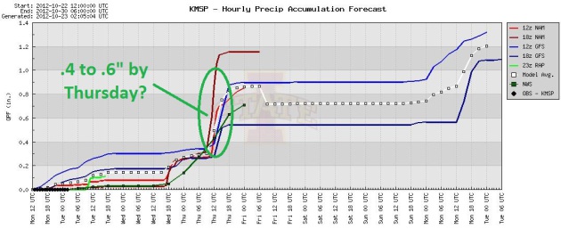 A Real Rain Event?
 I'm
tempted to discount this, because we haven't been very lucky in the
rainfall department in recent months, but the models all print out
roughly a half inch of rain late Wednesday into Thursday. I hope the
models are right.
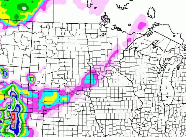
Thursday Touch of Slush? The NAM model shows a cold
rain ending as a little slusny snow, a narrow stripe of wet snow from
Marshall to Willmar, St. Cloud and Brainerd, where wet snow may
accumulate on lawns and fields by Thursday evening. With recent warmth
much of this snow may melt on contact.
Near 70 Wednesday, 30 Degrees Colder By Sunday. The
ECMWF continues to print out a significant amount of rain late Wednesday
into Thursday afternoon, as a surge of Canadian air plows south. By
Saturday temperatures may struggle just to reach 40. Some moderation is
likely next week, 50+ readings by Tuesday and Wednesday.
Soggy Halloween - Dry For Hunting Opener. The
long-range outlook is changing, morphing, as new data arrives. Making a
semi-accurate forecast beyond 3-4 days is problematic when jet stream
steering winds are howling almost directly overhead. The GFS is
suggesting a cold rain for Halloween (30s north, 40s south), but dry
weather and 40s and 50s for the first weekend of November, for the
Firearms Hunting Opener in Minnesota. Stay tuned...
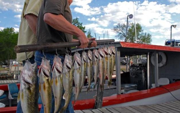
State: Walleyes On Mille Lacs Down In Numbers, Condition. Dennis Anderson has a story in the
Star Tribune; here's an excerpt: "
Mille
Lacs walleye abundance has fallen to its lowest level since 1972,
according to surveys completed this fall by the Minnesota Department of
Natural Resources. The disappointing survey results further complicate
the lake's walleye management. DNR fisheries researchers have worried
for some months that the lake's male walleyes were perhaps in short
supply. Test nettings found 4.8 walleyes per net, compared to 9.7 a year
ago, an unexpected decline, DNR fisheries managers said in a letter to
the Mille Lacs Input Group, a consortium of area resort owners, bait
businesses and others. And walleyes caught in the nets "were in poorer
condition than what is typically seen, especially for the larger
fish,'' the DNR said..."
"Ask Paul". Weather-related Q&A:
"
For the Twin Cities, are we looking at a winter closer to that of 2010-11, or a more mild winter such as last year (2011-12)?"
David Carroll
Lions Share Maintenance
David - I've mentioned it a few times on the weather blog. I suspect
our dry bias will hang on into at least the first half of winter, thru
December. A weak El Nino may steer the most significant storms well
south and east of Minnesota, but my gut (a "wish-cast"?) is that we'll
see more plentiful snows after the first of the year. I refuse to
believe that we could see two 20" winters, back to back. The odds of
this happening are slim. If I had to throw out an inch figure
(dangerous) it would be in the 40-45" range, so more than last winter,
but still almost half the snow that fell during 2010-2011, when a
strongly negative NAO (North American Oscillation) blocking pattern kept
a fresh supply of sloppy, southern storms pushing north across the
Plains. My gut is telling me this winter will be closer to last winter
than the 86" winter of 2011-2011, but I still suspect we'll see more
snow (and more cold) than last winter. Stay tuned...
Favorite Pics...
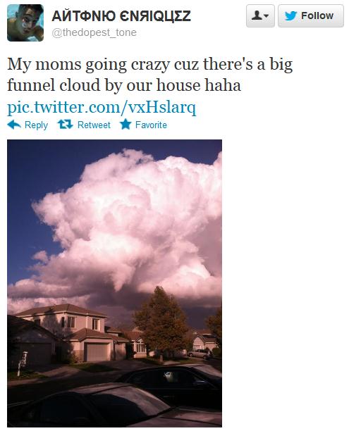
California Funnel Clouds. This photo was taken in Elk Grove, California.
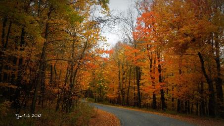
October Daydream. Larry G. Laird snapped this
photo in Center County, Pennsylvania over the weekend. Very nice.
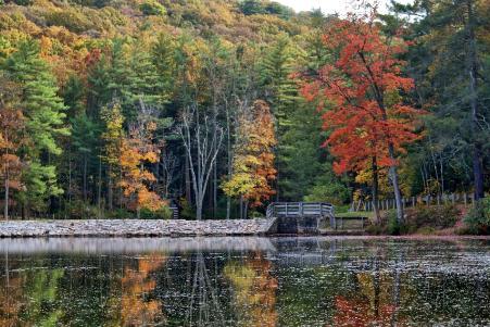
Rapid Ripening.
Timothy Garlick captured this photo near Altoona, Pennsylvania Sunday. Yes, I'd say it's close to peak color in the hills of south central PA.
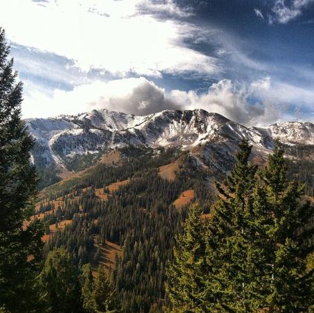
Sun Valley Panorama. The snow line is coming down -
looks (increasingly) like winter out there. Thanks to the Sun Valley,
Idaho Resort (and Instagram) for
this one.
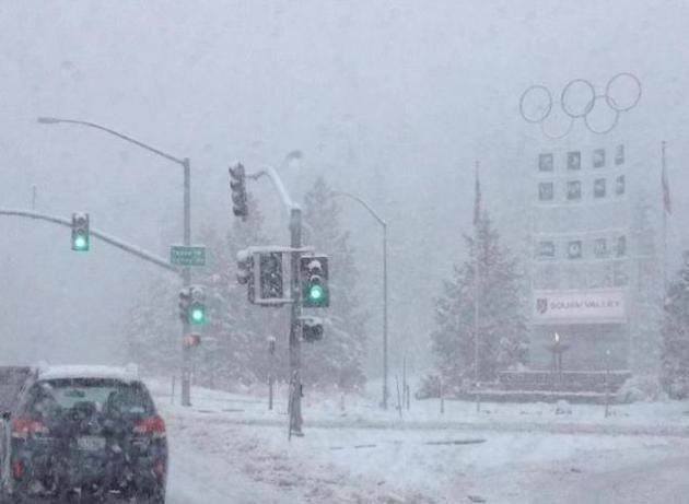
Looks Like Winter. Rachel Ward snapped this photo in North Lake Tahoe Monday. Looks like it might snow...?
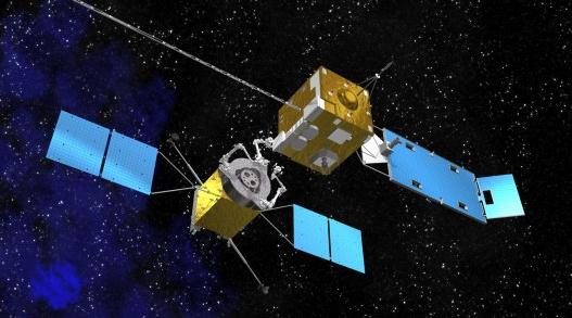
NASA Working On Refueling Satellites.
Gizmag.com has the interesting details - here's an excerpt: "
Geostationary
satellites cost a fortune and, despite their sophistication, they
break down or eventually run out of propellant to keep them oriented.
This is unfortunate when the nearest garage is back on Earth, so NASA
wants to remedy this with an orbital version of roadside service. The
space agency is developing a service robot that can visit ailing
satellites and refuel or even repair them on the spot. Geosynchronous
satellites are a vital part of the modern world. Orbiting 22,300 miles
(35,800 km) above the earth, they are a key link in global
telecommunications, and keep a constant eye on the planet’s weather..." Image above: NASA.
Scientists Convicted Of Manslaughter For Failing To Predict Italian Quake.
Wait a second. Do the Italians realize it's still scientifically
IMPOSSIBLE to predict a quake in advance? This one is a head-scratcher,
and may have a chilling effect for seismology; here's an excerpt from a
story at
ABC News: "...
Before
the verdict, 5,000 scientists from around the world signed a letter
supporting those on trial, arguing it was impossible to predict an
earthquake and accusing the court of putting science on trial. "It is
manifestly unfair for scientists to be criminally charged for failing
to act on information that the international scientific community would
consider inadequate as a basis for issuing a warning," said the
letter, signed by Alan Leshner, the CEO and executive published of the
journal Science. "Subjecting scientists to criminal charges for
adhering to accepted scientific practices may have a chilling effect on
researchers, thereby impeding the free exchange of ideas..."
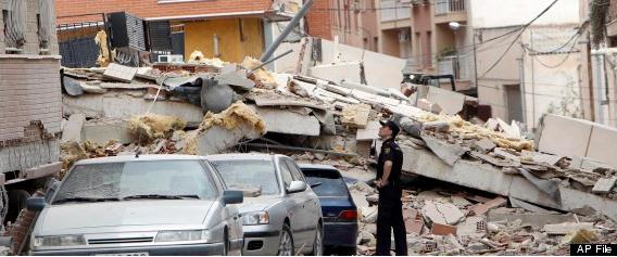
Spain Earthquake, Drilling Wells Linked In New Study Of Lorca Tragedy. A link between drilling deep wells for water extraction and possible earthquakes? Here's an excerpt of a story at
Huffington Post: "
Farmers
drilling ever deeper wells over decades to water their crops likely
contributed to a deadly earthquake in southern Spain last year, a new
study suggests. The findings may add to concerns about the effects of
new energy extraction and waste disposal technologies. Nine people died
and nearly 300 were injured when an unusually shallow magnitude-5.1
quake hit the town of Lorca on May 11, 2011. It was the country's worst
quake in more than 50 years, causing millions of euros in damage to a
region with an already fragile economy. Using satellite images,
scientists from Canada, Italy and Spain found the quake ruptured a
fault running near a basin that had been weakened by 50 years of
groundwater extraction in the area..." Photo above: AP.
iPad Mini Pricing May Have Been Leaked. More details on the forthcoming announcement from Apple from
gizmag.com; here's an excerpt: "
Like most of Apple's recent products, many of the iPad Mini's details have leaked.
It will probably sport a 7.85-inch display with narrow bezels, share
many internals with the iPad 2, and be ridiculously light and thin. The
biggest remaining question, then, may be the tablet's price. If a new
report has any legs, we may now know that too. As reported by 9to5Mac,
the base model of the iPad Mini (or iPad Air?) will ring up at US$329.
The tablet would also be available in models with extra storage, each
of which would add $100 in increasing increments.."
A Diamond Bigger Than Earth? I hope my wife doesn't read this post. Details from
Reuters; here's an excerpt: "
Forget the diamond as big as the Ritz. This one's bigger than planet Earth. Orbiting
a star that is visible to the naked eye, astronomers have discovered a
planet twice the size of our own made largely out of diamond.
The rocky planet, called '55 Cancri e', orbits a sun-like star in the
constellation of Cancer and is moving so fast that a year there lasts a
mere 18 hours. Discovered by a
U.S.-Franco research team, its radius is twice that of Earth's and its
mass is eight times greater. It is also incredibly hot, with
temperatures on its surface reaching 3,900 degrees Fahrenheit (2,148
Celsius)."
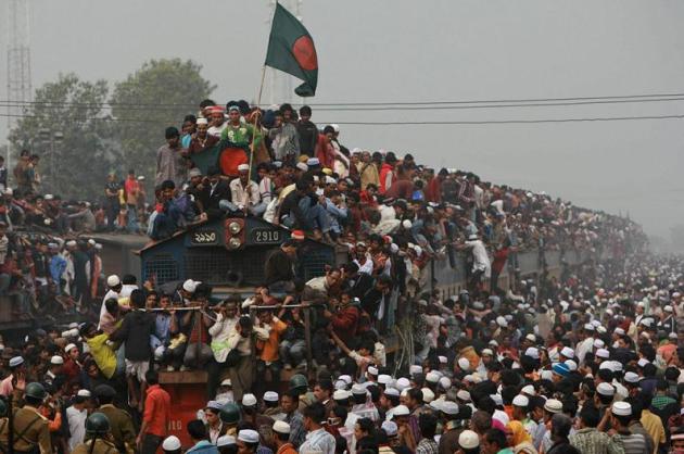
Feeling Better About My Commute. This photo was taken in India. Good grief...
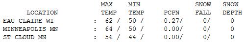
An Easy Monday. Mondays are rough enough - at least
the weather cooperated. Skies were gray, but temperatures were 5-10
degrees warmer than average, ranging from 56 at St. Cloud to 61
Alexandria to 64 in the Twin Cities. Over a quarter inch of rain fell at
Eau Claire.
Paul's Conservation Minnesota Outlook for the Twin Cities and all of Minnesota:
TODAY: Morning showers, skies brighten a bit by afternoon, still mild. Winds: South 5-10. High: 69
TUESDAY NIGHT: Mild with clouds and patchy fog. Low: 58
WEDNESDAY: Last warm day. Few showers, passing T-storm? High: 64
THURSDAY: A cold rain tapers, Windy & much colder (rain may end as a little wet snow up north). Low: 42. High: 48
FRIDAY: Chilled sunlight, heavy jackets return. Low: 30. High: 44
SATURDAY: A brisk blue sky - feels like early November. Low: 28. High: 43
SUNDAY: More clouds than sun, chilly. Low: 29. high: 49
MONDAY: Fading sun, not as cool. Low: 33. High: near 50
Climate Stories...
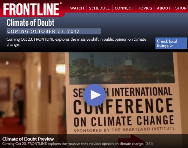
DVR-Worthy. Be sure to tune in or record "
Climate of Doubt",
a Frontline documentary on PBS tonight, focused on the climate denial
machine. Here's a preview in a Frontline press release: "...
Climate
of Doubt describes the individuals and groups behind an organized
effort to attack science by undermining scientists, and to unseat
politicians who say they believe there is current climate change caused
by human activity. Andrew Dessler, a climate scientist at Texas
A&M, says, “I fully expect that after this program airs I’ll get
another FOIA request for all of my emails with you. And you know, I’ll
just deal with that. As a climate scientist, I think a lot about the
future. It goes with the job. And I want to make sure that in 50 years
or 100 years or 200 years, nobody could ever say we didn’t warn them.”
FRONTLINE also investigates the funding that powers the skeptic
movement in the name of free market, anti-regulation, small government
causes. Hockenberry finds that funding has shifted away from fossil fuel
companies to more ideological, and less public, sources. According to
Robert Brulle, a sociologist studying the funding patterns of these
groups, “The major funders of the climate counter-movement are
ideologically driven foundations that are very much concerned about
conservative values and world views...”
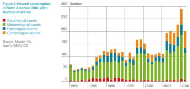
Study Finds "Climate Change Footprint" in North America, "Continent With The Largest Increases In Natural Disasters". Some interesting trends from global reinsurance company Munich Re, as reported in this
Think Progress story: "
“Climate-driven changes are already evident over the
last few decades for severe thunderstorms, for heavy precipitation and
flash flooding, for hurricane activity, and for heatwave, drought and
wild-fire dynamics in parts of North America.”
So concludes Munich Re, a top reinsurer, in a major new study
that, for the first time, links the rapid rise in North American
extreme weather catastrophes to manmade climate change. At the same
time non-climatic events (earthquakes, volcanos, tsunamis) have hardly
changed, as the figure shows. Prof. Peter Höppe, who heads Munich Re’s
Geo Risks Research unit, said:
“In all likelihood, we have to regard this finding as an initial climate-change footprint in our US loss data from the last four decades.
Previously, there had not been such a strong chain of evidence. If
the first effects of climate change are already perceptible, all
alerts and measures against it have become even more pressing.”
Communicating Climate Science. I don't pretend for a
second to have the Answer Key about the best methods for communicating
climate science, but I've been asked to put down my ideas on paper for
TV meteorologists interested getting up to speed and accurately
communicating the state of climate science in their markets. Here are a
few ideas that are top of mind:
Here is my "Top 10 Suggestions for Communicating Climate Science" list:
1). Stick to the science; peer-reviewed climate science. Avoid policy discussions with anchors.
2). Keep it current.
Viewers have become conditioned to expect breaking news. If there isn't
a major storm bearing down, consider a :15 to :30 update on climate
headlines. Sign up for (free) Google Alerts
for climate change and global warming will keep a steady stream of
timely articles coming to you every day. Which ones strike a nerve and
might be interesting/relevant for your viewers?
3). Bring it home.
Changes in the Arctic may not resonate with viewers. What does it mean
for me and my family? Show how polar amplification may be slowing
weather patterns, making droughts drier and storms even wetter. How will
this impact rising sea levels and possible water shortages? There are
always effective ways to personalize and localize the science.
4). Communicate with your News Director.
Local stations are licensed by the FCC to serve the public interest.
That means holding up a mirror to your community and showing the changes
taking place, and how climate change may impact your market in the
years to come. Remind your managers that you have an obligation, as
meteorologists, to communicate the science.
5). Your local Climate Office is a gold mine of data.
All TV meteorologists want to go beyond the 7-Day to provide analysis,
context and perspective. Tap data (and graphics) from your local climate
office to show how extreme rainfall events are increasing, winter
nights are trending warmer, with longer growing seasons for farmers.
6). Tease on-air, drill into details on-line.
We know you don't have enough time to explain all the science during
your regular TV weathercast. But you can share a couple of headlines,
and then point viewers to your web site for more details. Jim Gandy, Dan Satterfield and Mike Nelson have done a good job of explaining the science on-line, and helping to build an audience in the process. On my Star Tribune blog
I mix meteorology with climate science and articles that catch my eye,
addressing questions, comments and criticisms. On our new national
weather channel, “WeatherNation TV”,
we include brief climate science headlines with longer 3:00 segments
focused on the trends. This is a chance to show your scientific
credentials and push back against misinformation.
7). Look for local hooks.
How are farmers, fishermen, hunters, gardeners, insurance agents and
other people who spend extended time outdoors personally experiencing
climate change. A 20 second sound bite and one simple graphic can tell
the story; again - directing viewers to your station's web site for more
detail.
8). Weather is not climate. It’s tempting to look out the window and make global assumptions. Using NOAA, NCDC and NASA tools you can help viewers keep a global perspective, using temperature anomaly maps to explain the trends.
9). Dig into the science.
The debate is over. This is more than a “natural cycle”. What we’re
seeing, worldwide, was predicted 30 years ago, and changes are
accelerating even faster than predicted. Remind viewers not to rely on
dubious blog links or talk radio to get their science. It should come
from you, and the only way to make it accurate and timely is to spend
the time and get up to speed on peer-reviewed climate science yourself.
Become the local climate expert. It will only add to your credibility
and the trust and equity you’ve built up in your market.
Good luck!
Addressing Climate Change Is Pro-Business. Here's an excerpt of a timely article at Think Progress: "
An
ongoing argument in the presidential election campaign is whether Gov.
Romney’s or President Obama’s positions are better for small
businesses on issues such as government regulation and energy policy. I
asked David Levine for his opinion. Levine is cofounder and CEO of the American Sustainable Business Council
(ASBC), a growing non-partisan coalition of business networks and
businesses committed to creating a vision, a framework and policies that
support a vibrant, just and sustainable economy. Founded in 2009,
ASBC’s mission is to inform and engage business leaders, and to educate
policy makers and the media, about the need and opportunities for a
sustainable economy..."
Nobody Mentions Climate Change. But Somebody Did Something About It. Here's a clip from a "Swampland" post at
Time Magazine: "
I
constantly whine about the Beltway media, and I believe global warming
is the most important issue facing humanity. So I was infuriated but
not surprised to hear Candy Crowley explain after the last debate that
she considered a question for “you climate change
people,” but ditched it because “we knew the economy was still the
main thing.” Actually, the technical term for people affected by
climate change is “people.” It’s already an economic issue—drought
is overwhelming the middle of the country—and, memo to Bob Scheiffer,
it’s a foreign policy issue, too. But unless Schlieffer asks about it
tonight in Boca, this will probably be the first election
since 1984 that climate change doesn’t come up in a debate, and the
candidates certainly haven’t been raising the issue themselves..."
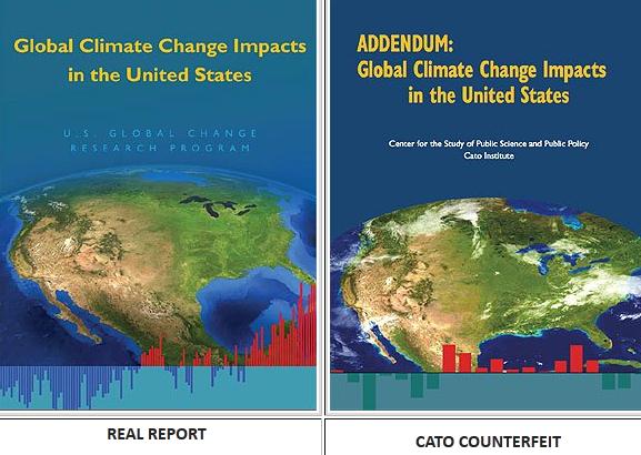
Is Patrick Michaels Trying To Pass Us a Counterfeit $20 Bill? An explanation from
Global Warming, Man or Myth - here's an excerpt: "
What
if I were to tell you that the one on the left was provided by a
member of the United States Treasury and had the endorsement of
virtually every currency expert on the planet? What if I told you that
the one on the right was passed by a guy who has a history of deception
and that virtually every currency expert thinks the one on the right is
fake? I am guessing that you think the one on the left is real and the
one on the right is a fake because you considered the credibility of the people who passed that bill to you. Now keep your “credibility eyes” open when Patrick Michaels tries to pass you a counterfeit document that is supposed to make you and our elected officials believe climate change is not a major concern for the United States..."
Scientific American has more on the Cato "report", designed primarily to confuse members of Congress,
here.


No comments:
Post a Comment