78 F. high in the Twin Cities Wednesday.
64 F. average high for October 3.
83 F. high on October 3, 2011.
Winter Storm Warning in effect for the Red River Valley, for 6-10" of heavy wet snow by Friday.
First flurries of the winter season possible in the metro area by Saturday.
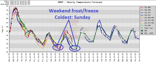
Frost possible Saturday, a frost/freeze is even more likely Sunday morning for even the close-in suburbs.
Indian Summer. 60s &
70s return to much of Minnesota from late next week thru October 18.
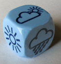
First Metro Flakes on Saturday? Models consistently
bring a pool of unusually cold air over MSP Saturday, an "upper level
disturbance" capable of a few light showers of rain and wet snow, even
in the metro. Accumulation? Doubtful, but not impossible, depending on
the timing. Last year the first flurries reached the metro November 9.
I have a hunch it may be more than a month earlier than that this time
around. Graph: Iowa State.
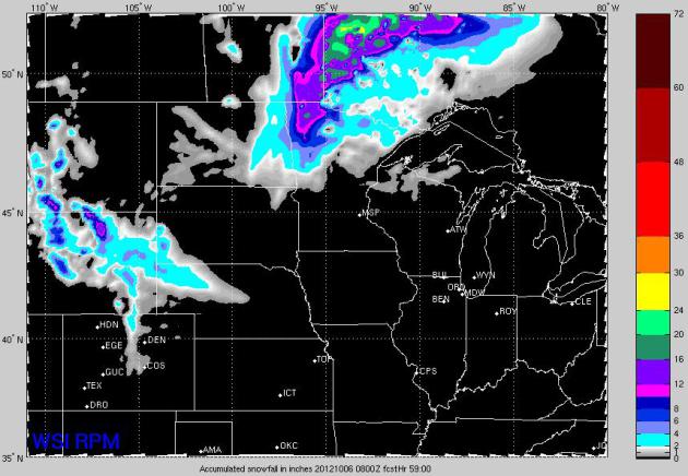
Answer Key. WSI (Weather Services International)
runs a high-resolution (RPM) model that tends to do a very good job
during most snow situations. Much of northern Minnesota is forecast to
pick up at least 1-2" of snow, with a 100 mile wide swath of 6-12" from
near Thief River Falls northward to Roseau.
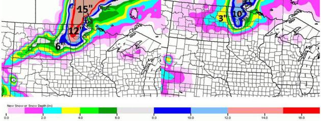
Dueling Models. The NAM model (upper left) prints
out more snow than the GFS (upper right), but there's little doubt that
5-10" of heavy, wet snow will fall on northwestern Minnesota by midday
Friday. A light coating to 1" is possible for Fargo/Moorhead, a few
inches at Bemidji and International Falls, with the greatest potential
for heavy snow from Thief River Falls to Hallock and Roseau.
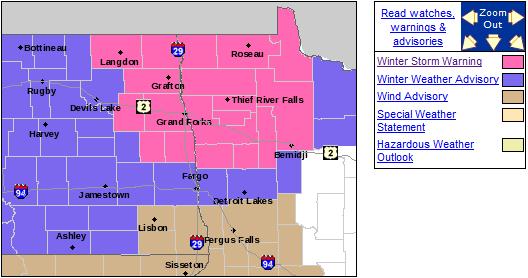
Winter Storm Warning. A warning means potentially
dangerous, wintry weather is imminent - it usually means 6" or more of
snow is a fairly good bet. Details on the Winter Storm Warning:
...EARLY WINTER STORM ACROSS THE NORTHERN RED RIVER VALLEY INTO
NORTHWEST MINNESOTA THURSDAY AND THURSDAY NIGHT...

.A LOW PRESSURE SYSTEM WILL DEVELOP AND MOVE INTO CENTRAL
MINNESOTA THURSDAY. AS THIS SYSTEM DEVELOPS...RAIN WILL SPREAD OVER
THE REGION TONIGHT. THE RAIN IS EXPECTED TO MIX WITH AND THEN
CHANGE OVER TO ALL SNOW BY THURSDAY MORNING FROM WEST TO EAST. THE
SNOW MAY BE HEAVY AT TIMES ON THURSDAY...ESPECIALLY ACROSS THE NORTHERN
RED RIVER VALLEY INTO NORTHWEST MINNESOTA. SNOW ACCUMULATIONS FROM 6
TO 10 INCHES ARE EXPECTED IN THE NORTHERN RED RIVER VALLEY...AND
10 TO 12 INCHES ACROSS PORTIONS OF NORTHWEST MINNESOTA. NORTH
WINDS WILL STRENGTHEN BY THURSDAY...LEADING TO AREAS OF NEAR
BLIZZARD CONDITIONS IN FALLING AND BLOWING SNOW IN THE NORTHERN
RED RIVER VALLEY.
 First Stab Of Winter
.
Fresh surges of bitter air often spin up strong storms; the greater the
contrast in temperature the stronger the winds and potential for
intensification. A vigorous storm blows up over the Red River Valley,
the heaviest snow bands setting up just north/west of the storm track,
dumping some 5-10"+ amounts on much of the Red River Valley. Showers and
T-storms stalk Florida, while the western USA
remains dry and seasonably warm. NAM model data courtesy of NOAA.
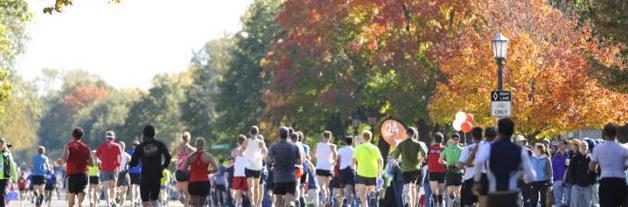
Medtronic Twin Cities Marathon Outlook: No concerns
about heat exhaustion this year. Just be glad you're not running
Saturday, the colder, windier, more November-like day of the weekend.
Expect a morning frost/freeze with wake-up temperatures around 28-31 F,
but morning temperatures should rise quickly thru the 30s into the 40s
under a blue sky. Winds ease up a bit, blowing from the west at 5-15
mph. All in all a kinder, gentler day than Saturday. For more details on
this year's Medtronic Twin Cities Marathon
click here. Good luck!
* will climate change slow marathon times? Hmm. Not this year, at
least not in the Twin Cities. Mother Nature Network takes a look at this
vexxing question
here. More details below.
Metro Plants Are About To Freeze Their Buds Off. If
you've missed out on a frost so far this autumn your luck is about to
run out. Model ensembles are consistently bringing temperatures to or
just below 32 Saturday and Sunday morning. My hunch is that Sunday will
be the colder day of the weekend with less wind and more sun.
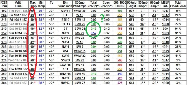
Extended Outlook: Lukewarm. The GFS model (which
goes out 16 days with some level of accuracy) is consistently showing a
warming trend from late next week thru October 18, give or take, a
streak of 60s, even a few days above 70.
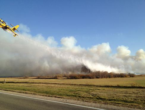
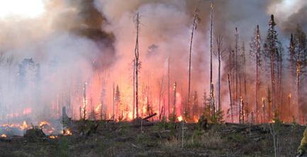
Karlstad Fire Contained; 7 Homes Lost. Far northwestern Minnesota will go from brushfires to shoveling snow, all the span of 48 hours. Amazing. Here's an excerpt of a comprehensive update on the recent blaze from AP and valleynewslive.com: "
Evacuees
have returned to their homes in a small northwestern Minnesota town
after fire crews contained a rapidly-spreading wildfire fueled by brisk
winds. State fire marshal Bruce Roed said Wednesday the fire is 95
percent contained and has not grown since Tuesday night when about 400
people returned to their homes in the Kittson County town of Karlstad.
The wildfire earlier burned about 12 square miles and destroyed six to
eight homes in the Karlstad area. Authorities evacuated Karlstad's
nursing home, school, assisted living center and a group home as the
fire blanketed the community in thick smoke..."
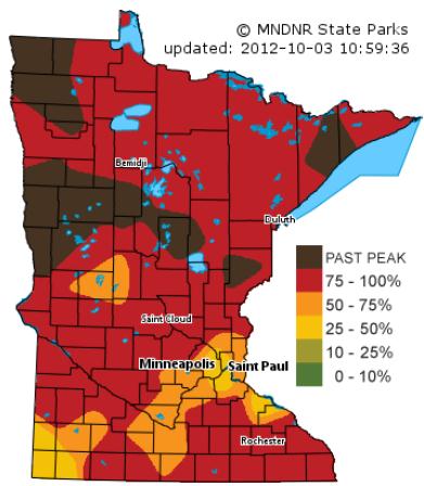
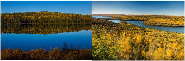
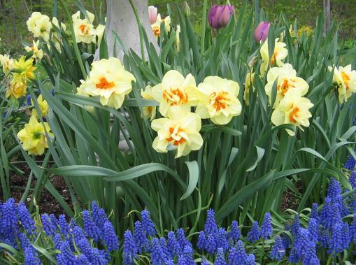
A Crescendo Of Color. Fall foliage is peaking across
Minnesota right now, already past-peak from near Brainerd westward to
Detroit Lakes and the Fargo/Moorhead area, as well as far northwestern
Minnesota. Strong winds today will bring down many leaves - we're
probably a week away from peak color in the immediate Twin Cities metro.
Map courtesy of the
Minnesota DNR.
"...Taken together, extreme events cost our country at least $55
billion in 2011. This year has delivered another round of extreme
events, from record-breaking heat waves to freak storms and devastating
wildfires. Purdue economist Chris Hurt estimates the
cost of the drought alone could rise to $77 billion." - from a Huffington Post story below.
"...
More than 90% of books published between 1972 and 2005 that
expressed skepticism about environmental issues" are not written by
climate scientists but "have been linked to conservative think tanks." And what is their goal? Misinformation." - from a Doug Craig post at "Climate of Change". Details and links below.
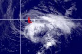
Resilient Nadine. "Nadine" has been a tropical storm
or hurricane for 21 days, and counting, making it the 5th
longest-lasting storm ever observed in the Atlantic. Details from
The Capital Weather Gang.
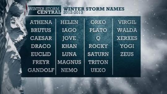
Like The Herald, Weather Channel Gets Into Name Game For Winter Storms. It turns out
The Grand Forks Herald newspaper
has been naming major winter storms for decades, naming them after
local hockey players, politicians, etc. Here's their take on the recent
announcement from TWC: "
When the next big blizzard rolls around, the
Herald might not be the only news organization giving it a name — The
Weather Channel said Tuesday it too will join the fun. The weather news
behemoth said it would be the first national organization in North
America to name winter storms. “Our goal is to better communicate the
threat and the timing of the significant impacts that accompany these
events,” the organization said. “The fact is, a storm with a name is
easier to follow, which will mean fewer surprises and more preparation..."
A Storm About Naming Storms. Marketing gimmick or
something more? Hurricanes are named because it's easier to remember a
name than a number (or "Alpha", "Bravo", "Charlie" etc). But blizzards?
Here's a portion of a post at
Digital Meteorologist that purports to explain the real reason why TWC is naming blizzards this winter: "...
So, when TWC’s new winter weather expert Tom Niziol claims,
“Naming winter storms will raise awareness, which will lead to more
pro-active efforts to plan ahead, resulting in less impact on the public
overall”, we simply have to take his word for it that it’s a good
thing and hope the parallels to naming tropical storms and hurricanes –
which we have been doing for decades for many of the very same reasons
– hold up. But make no mistake about it: This is not only, or even
primarily, about raising awareness about storms or reducing the impact
on the public.
A nuclear bomb of marketing
Sure, calling that next winter storm by a proper name will get
people talking, and that will help ensure a high awareness of winter
storms. Then again, is that ever a problem? No, and this is more
about marketing and branding than improving weather communication with
the public, and TWC tips their hand in the fourth bullet above when
they mention social media..."
At The Weather Channel It's Marketing First, News Second.
Maybe I'm not quite as cynical as a number of other weather
enthusiasts. Any large media company needs to promote effectively. I
don't think any of us should be shocked to discover that naming
blizzards is less a public service than a potential
home run on
the marketing and visibility side. Look at all the press TWC has gotten
since the announcement. Here's another perspective from
mghus.com: "
The
Weather Channel, the cable network that has progressively shifted from
local forecasts on “the 8’s” to a primetime line up filled with
original reality series programming, took another step today toward
being more marketing machine than news organization by announcing its plan to name winter storms this year.
To avoid confusion with tropical storm and hurricane names, which are
created by the World Meteorological Organization and then used by the
National Hurricane Center (an office within the federal government’s
National Oceanic and Atmospheric Administration), many of the names are
a bit, shall we say, “different.” Draco, Gandalf, Q and Yogi, just to
name a few. Since tropical storms and hurricanes are named by the
federal government, all news organizations feel an obligation to report
on them using these names. This creates a common language and ensures
the public understands government-issued alerts pertaining to the
storms..."
TV Weathercasters Criticize Unilateral Action by The Weather Channel On Storm Naming.
Uh oh. Can you say meteorological smack-down? Atmospheric rumble? The
knives are coming out, as highlighted in this excerpt of an article at
The Washington Post's
Capital Weather Gang: "
A day after The Weather Channel (TWC) announced plans to name winter storms,
a number of broadcast meteorologists are expressing significant
concerns about the initiatve. Most don’t have a conceptual problem with
the act of naming storms, but TWC’s failure to coordinate with the
rest of the meteorological community on the initiative is being viewed
by many as self-serving and not in the interest of coordinated weather
communication. Andrew Frieden, a broadcast meteorologist in Richmond, put it bluntly: “Weather Channel to name Winter Storms! First Thought: “Who died and made them King?!” Graphic above: weather.com.
* personally, I'm kind of looking forward to Yogi, the blizzard. Not
sure why so many of my colleagues are getting their undies in a bunch.
It's America, Land of the Free, Home of Creative Marketing and Endless
Corporate Hype! I say let them name these storms and let's see how it
goes. Life is too short to get agitated over storm names. Good grief...
TWC Storm Naming "Will Mislead Public". Here's an excerpt from the latest volley by arch-competitor,
Accu Weather: "
The
Weather Channel announced Tuesday that they plan to begin naming
"noteworthy" winter storms in the 2012-2013 season. The decision has led
to an outpouring of comments and criticism on the web, and particularly
on social media outlets. After reviewing The Weather Channel's release
in its entirety and taking into account all factors, Dr. Joel N. Myers,
AccuWeather Founder and President, released the following statement:
"In unilaterally deciding to name winter storms, The Weather Channel
has confused media spin with science and public safety. We have explored this issue for 20 years and have found that this is not good science and will mislead the public. Winter storms are very different from hurricanes.
..."
* Ouch. Stay tuned for the latest on Blizzard-Name-Gate.
"Ask Paul". Weather-related Q&A:
Paul
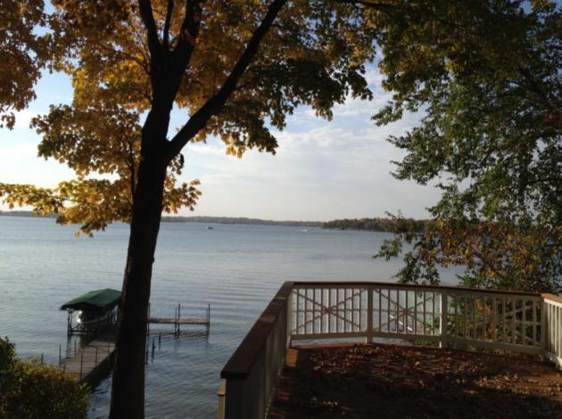
Here are 2 pics from a canoe trip I took to the
BWCA last weekend. The first is a great reflection from a small pond on
the Gunflint Trail. The other is from an overlook on the Border Route
Trail looking at South Lake, Rat Lake and Rose Lake from left to right.
Such an amazing weekend with beautiful fall colors and a crisp blue
sky!
Lastly, can you give some specific forecasts for
the marathon this weekend? It's always kind of tricky deciding what to
wear in that 25-40 degree range. Thanks!
Steve Burns
Thanks Steve - it's amazing how fast the colors ramped up, just in
the last 1-2 weeks. I'm hearing rave reviews from Twin Cities residents
who made the trip up north to check out the colors. Check out the top of
today's blog for a first look at Sunday's weather for the Twin Cities
Marathon. And thanks for sharing these!
Paul
_________________________________________________________________________
Paul -
Your column on core-suburban (Wednesday) morning
puts specific numbers on something I’ve known but not had numbers for.
But it raises a question that’s important to those of us who garden. Are
the numbers forecast in the newspaper for the core cities or for the
outer suburbs? My understanding is that NWS forecasts for the airport,
which is a little cooler than south Minneapolis.
Steve Brandt
Reporter
Star Tribune (Minneapolis)
612-673-4438
Hi Steve,
You bring up a very good question, one we wrestle
with all the time. The forecast numbers I provide are for MSP
International, where the “official” measurements are taken by the local
NWS. It’s not a perfect set-up, but it’s a baseline, an attempt to have
some continuity on the forecast/verification side.
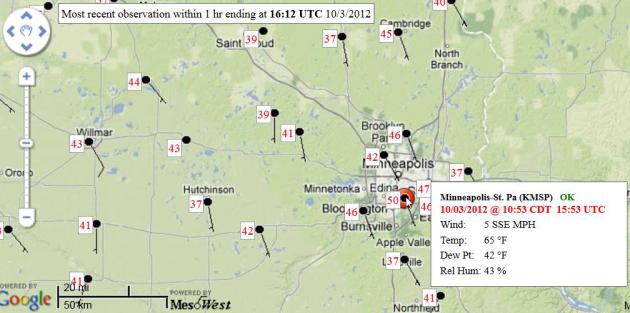
The reality: MSP International is something of a
compromise, consistently 1-3 F. cooler than the downtowns, a fairly good
indicator of what close-in suburbs will experience with temperatures.
On a clear night with light winds there can be a 10-13 F. temperature
difference between (downtown) Minneapolis and St. Paul and outer
suburbs, like Lakeville, Stillwater and Ham Lake to the north. The map
above (
MesoWest)
shows Wednesday morning's observed low temperatures, ranging from 50 at
MSP International to 41 Northfield, 37 Lakeville, 39 St. Cloud and 37
at Princeton, a perfect example of the urban heat island.
It gets to a core question: where are you
forecasting for? Since 80% of the population lives in the Twin Cities
metro there’s a strong bias to make the forecast temperatures reflect
what 80% of the readership will experience, but we all know there are
huge temperature variations, across the MSP metro, and across the rest
of the state.
But to answer your question: for better or worse,
the forecast temperature is for MSP International, since that is where
the NWS takes official measurements, and where we have a strong
historical baseline of observed temperatures.
Paul
__________________________________________________________________________
Hey Paul - Just wondering if you have any idea how
much its going to snow this winter? I have to let my snow plow guy know
if I want to pay monthly or by each time he shows up. It's $150
unlimited monthly or $50 each time he comes. I've always done the
unlimited monthly, but I took a major financial hit last winter because
he only came 4 times all winter.
Is this winter looking to be like last year's
pitiful winter, or more like the previous year's awesome winter, when we
got the 100 inches?
Thanks
Jeff Fischer
Jeff - if I could nail that question I'd be hanging out with Mitt
Romney. That's the truth, and anyone who has a high level of confidence
about what the winter will bring is trying to snooker you. Buyer beware.
It's like trying to predict where the S&P 500 will be in February,
or interest rates next March. Good luck with that. Billions of variables
involved, a handful of which may prove critical.
We have a (mild) El Nino, but this warm stain of
water is forming in the central Pacific, where impacts on Minnesota
winters are less direct. Odds favor a wetter than average winter for the
Pacific Northwest and the Southeast, but there is no strong signal for
the Upper Midwest. As I've been saying (ad nauseum) for weeks, the
Arctic is a huge wildcard. Record melting and a subsequent warm dome of
high pressure at the top of the world may displace the main "polar
vortex", the most bitter air, farther south, increasing the odds of more
numbing fronts for Minnesota than last winter. Factor in the fact that
winters have been trending milder in recent decades and you're left with
a muddled, confused outlook.
My gut, and that's all it is, a semi-educated gut
feel, is that we'll have a tougher winter than last year: more snow, and
more cold. I just can't believe we'll have two easy winters, back to
back. Overall I still suspect it'll wind up (a little) milder than
average, but I'm fairly convinced we'll see more snow than last winter's
paltry, pathetic 22", but not nearly as much as 2010-2011, when more
than 86" buried the metro. If I had to guess, and that's all it is,
a guess, I'd go with 40-45" of snow, and more subzero nights than last winter (when we had only 3 nights of negative numbers).
Personally, I'd go with the unlimited monthly plow
option this winter, and not pay $50 a pop. I hope I'm giving you good
advice. Let me know how it worked out for you next spring ok?
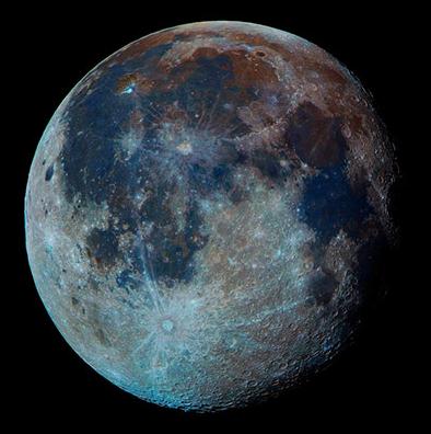
Some pretty sky sites in the next week or so:
Thursday night/Fri morning Oct 4/5
At 11:30 p.m., Jupiter about 7 degrees below left of Moon. Look low in east
By 5 a.m., Jupiter left of Moon, high in south
Friday night/Saturday morning Oct 5/6
At 11:30 p.m., Jupiter 5 degrees above right of Moon. Look low in east
By 5 a.m., Jupiter right of Moon, high in south
Thursday, Oct 11 5:30 to 6 a.m.
Thin crescent Moon 13 degrees above right of bright Venus, low in east
Friday, Oct 12, 5:30 to 6 a.m.
Very thin crescent Moon 5 degrees right of bright Venus, low in east
Clear skies
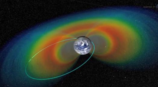
NASA's Radiation Belt Storm Probes Record Electromagnetic "Earthsong". Here's a fascinating snippet of an article at
gizmag.com: "
NASA’s twin Radiation Belt Storm Probes
(RBSP) took a musical interlude and listened to the Earth singing to
itself. This “Earthsong,” as NASA calls it, was recorded by the two
spacecraft as they orbited inside the highly radioactive Van Allen Belts
that surround the Earth. The “song” is in the form of radio waves
generated by the belts and the study of it may provide a clue toward
answering the question of how to protect satellites and astronauts from
deadly radiation storms." Image above: NASA.
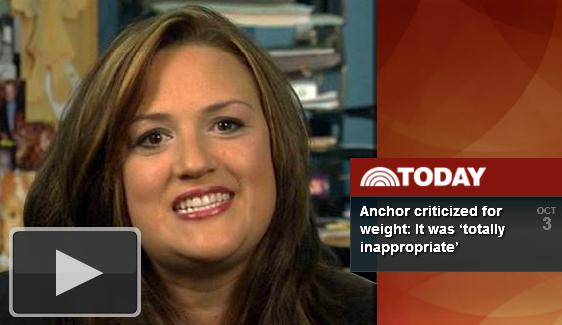
Following On-Air Editorial On Her Weight, Jennifer Livingston Appears On Network Morning Shows.
I have to give this woman credit for stepping up and calling attention
to this. So many of us are quick to make snap judgments and stereotypes.
Here's an excerpt of a story (and accompanying video) from
TVspy.com: "
Just a day after Jennifer Livingston delivered a gutsy on-air editorial responding to a viewer complaint about her weight, the WKBT
anchor told her story on the three network morning shows. “This was a
personal attack,” Livingston said on ABC’s “Good Morning America”
(video above). “Calling me obese is one thing. Calling me a bad role
model to our community that I’ve worked at for 15 years, and especially
young girls when I have three girls, was a low blow. I thought it was
uncalled for, and I wanted to call him out on it.” Livingston, who is
the sister of actor Ron Livingston, appeared on “GMA” with her husband, WKBT evening anchor Mike Thompson, and on NBC’s “Today” and “CBS This Morning” solo."
Be Happier: 10 Things To Stop Doing Right Now. This story at
inc.com caught my eye. Of course I don't do any of these, but just in case YOU do, here's an excerpt: "
Happiness--in your business life and your personal life--is often a matter of subtraction, not addition.
Consider, for example, what happens when you stop doing the following 10 things:
1. Blaming.
People make mistakes. Employees don't meet your expectations. Vendors don't deliver on time.
So you blame them for your problems.
But you're also to blame. Maybe you didn't provide enough
training. Maybe you didn't build in enough of a buffer. Maybe you asked
too much, too soon..."
Photo credit above: Flickr Creative Commons.
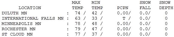
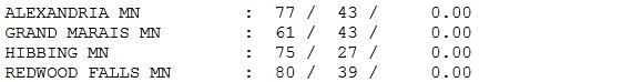
So Long Summer. We'll see more warmth, of that
I have no doubt. More 60s and a few more 70s are likely before the
flakes begin to fly on a regular basis. Wednesday was yet another
extraordinary day with blue sky giving way to increasing clouds late in
the day. Highs ranged from 61 at Grand Marais to 77 at St. Cloud, 78
Twin Cities and 80 at Redwood Falls.
Paul's Conservation Minnesota Outlook for the Twin Cities and all of Minnesota:
TODAY: More clouds than sun, blustery and much
colder. (heavy wet snow far northwestern MN). NW 15-35, gusts over 40
mph. High: 52
THURSDAY NIGHT: Partial clearing Low: 35
FRIDAY: Partly sunny. Flurries up north. High: 47
SATURDAY: Heavy jackets. Frosty start - clouds increase, PM sprinkle or flurry? Low: 31. High: 44
SUNDAY: Brisk Twin Cities Marathon. Sunny & cool with less wind. Low: 29. High: near 50
MONDAY: Sunny, milder. Indian Summer returns! Low: 39. High: 62
TUESDAY: Early shower possible, then clearing. Low: 40. High: 58
WEDNESDAY: Blue sky, classic fall weather. Low: 33. High: 56
Rolling Dice
Jeff Fischer writes: "Hey Paul - Just wondering
if you have any idea how much its going to snow this winter? I have to
let my snow plow guy know if I want to pay monthly or by each time he
shows up?" Hmm. Jeff, if I had a definitive, scientifically-sound answer
to that (excellent) question I'd be hanging out with Mitt Romney.
Here is what I suspect: we probably won't have 2
easy winters, back to back. It won't be as Memphis-like as last winter
(22 inches), but not as severe as 2010-2011, when 86 inches swamped the
metro. El Nino probably won't save us, and in spite of a trend toward
milder winters since the 90s - record Arctic melting may displace the
polar vortex farther south.
The drought is flavoring all weather now, and I
don't see any sudden shift in that department. Bottom line: I think
we'll be colder than last winter, but still milder than average,
overall. I'm thinking 40-45 inches of snow for MSP (give or take 30
inches). I'd sign up for the monthly plan.
Brushfires give way to 5-10" snow for northwest
MN today. A few flurries may drift into the metro Saturday. A weekend
freeze gives way to 60s & 70s by mid-October.
Whew.
Sunday Marathon weather updates on the blog.
Climate Stories....
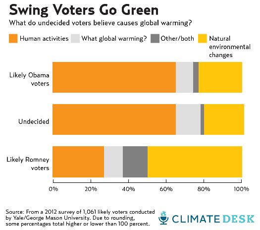
Is Climate Change The Sleeper Issue Of 2012? It
turns out not just Democrats are interested in this topic, but a
significant number of moderates and independents. Here's an excerpt of a
very interesting article at
Mother Jones: "...
Recent polling data make clear, however, that extreme weather is leaving Americans increasingly worried about climate change. A mid July survey
from the University of Texas at Austin, for instance, found that 70
percent of the public thought climate change was happening, an increase
from 65 percent in March. What's more, a series of public opinion
reports and analyses—some based on data collected prior to the record
heat waves of the summer, which suggests the public is even more alarmed
now than when those surveys reached them—have indicated that global
warming is a potential political winner, rather than an electoral
albatross..."
Will Climate Change Slow Marathon Times? Say what? That was my first reaction, but after reading this article at
Mother Nature Network I see what they're driving at; here's an excerpt: "
Climate
change is blamed for melting ice, shrinking animals and brewing more
intense storms around the globe — but is it slowing the top finish
times at the Boston Marathon? Not yet, researchers found, though future
increases in temperature could mean fewer records are broken. Runners
typically dread hot race days. Warmer temperatures tend to drag on
finish times, studies have shown, and the slower you run, the more
minutes you're likely to pile on during a boiling hot day. This year saw
one of the hottest marathons in Boston,
with temperatures on April 16, 2012, soaring into the 80s — about 20
degrees Fahrenheit (11 degrees Celsius) higher than the normal high.
Though that race day was unseasonably warm, temperatures in Boston have
been rising at a relatively high rate over the past century..."
Earth's Carbon Sink Downsized. "But extra CO2 is
GOOD for plant life - think how big the plants will get!" I hear that a
fair amount, but latest research from the good 'ol University of
Minnesota suggests otherwise. Here's an excerpt from
Nature: "...
Some
scientists have argued that the increase might even be good for
plants, which would presumably grow faster and mop up even more CO2.
Climate models estimate that the world’s oceans have absorbed about 30%
of the CO2 that humans have released in the past 150 years
and that land plants have gulped another 30%. But the latest study, by
ecologists Peter Reich and Sarah Hobbie at the University of Minnesota
in St Paul, suggests that estimates of how much CO2 and plants can use
are far too optimistic. Plants also need soil nutrients, such as
nitrogen and phosphorus, to grow. But few studies have tested whether
soils contain enough of these nutrients to fuel growth in proportion to
rising CO2."
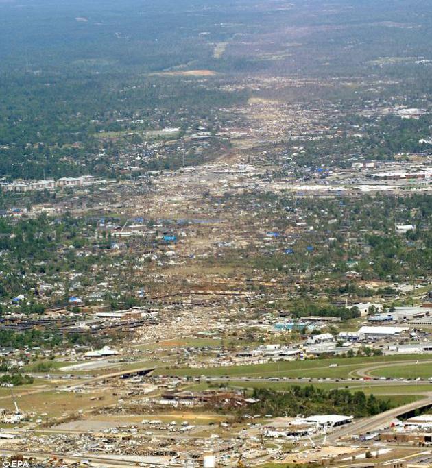
Disaster Planning And Climate Change. Here's a clip from a story at
Huffington Post that's worth a read: "
Fall
may have arrived, but it hasn't brought an end to the great drought of
2012. My home state of Nebraska has been hit hard, with nearly 98 percent of the state
still experiencing extreme or exceptional drought. Friends and family
have told me that cities have restricted water use, farmers have plowed
their crops under, and ranchers have thinned their herds. Tens of
thousands of acres have caught fire across the state, and fire
departments have had to ask for emergency increases
in property taxes to cover the cost of fighting the flames. Residents
of the Great Plains are no strangers to erratic weather, but this year
has been hotter and drier than any in recent memory. We could chalk it
up to a one-time anomaly, except climate change is loading the dice and
making these arid conditions more and more likely. Scientists say climate change is increasing the frequency and intensity of extreme weather events like drought, heat waves, downpours, and intense storms." Image: EPA.
"The Greatest Moral Issue Of Our Times". Here's a snippet from a story at
mlive.com, focused on a group of professors at Western Michigan University and their efforts to get the word out: "...
Climate
change “is causing millions of innocent deaths, destroying livelihoods
and threatening major changes to the world that future generations
will inherit,” reads a university release. The professors will also
speak about the effects such as the risk of widespread extinctions,
loss of land due to sea level rise and forced population movements."
Misinformed On Climate Change. Here's an excerpt of another excellent post from Doug Craig in his "
Climate of Change" series at redding.com: "...
And there is a name for this "process of willful manufacture of mistaken beliefs." It is called "agnogenesis." Most of us know that back in 2006, "a
U.S. federal court ruled that major domestic cigarette manufacturers
were guilty of conspiring to deny, distort, and minimize the hazards of
cigarette smoking." What most Americans may not know is that "starting
in the early 1990s, the American Petroleum Institute, the Western
Fuels Association (a coal-fired electrical industry consortium), and
The Advancement of Sound Science Coalition (TASSC; a group sponsored by
Philip Morris) drafted and promoted campaigns to cast doubt on the science of climate change." Their
goal was vast dissemination of misinformation and as anyone who has
ever read the posts following any of my blogs, they have had over two
decades of outstanding success..."
Is Business Our Last Great Hope On Climate Change? Here's an excerpt from a thoughtful post at
greenbiz.com: "
As
I sit here writing this article, it has started raining again here in
London. No surprises there, you might think. But even by soggy British
standards, this summer has been extreme — the wettest for a century,
meteorologists say. Communities in the north of England are under
several feet of water, for the second time in less than three years.
Meanwhile, on the other side of the Atlantic, North America was until
recently sweltering in a lengthy heat wave that has resulted in an
estimated 82 deaths, while scientists report that the extent of polar
ice melt this year has broken all records. With mounting signs of a
changing climate such as these, anyone trying to identify which issue
should be at the heart of a company’s sustainability strategy -- and
looking for clues as to where citizen and consumer expectations are
headed -- might have expected public concern to be on the rise. But
this does not appear to be the case..."


No comments:
Post a Comment