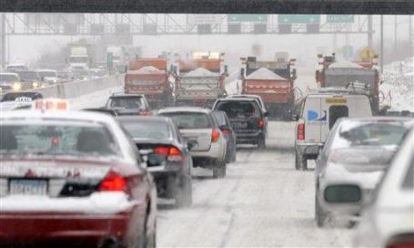
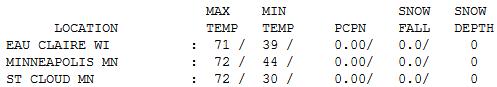
72 F. high in the Twin Cities Tuesday.
65 F. average high for October 2.
80 F. high on October 2, 2011.
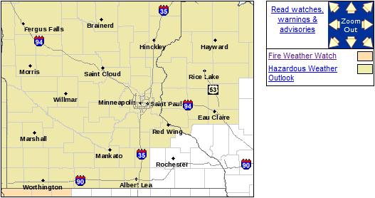
Fire Weather Watch posted for most of Minnesota, including the Twin Cities.
November 9, 2011. First flurries spotted in the Twin Cities.
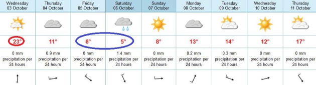
October 6, 2012. There's a chance of flurries in the Twin Cities metro this Saturday. It's not definite. Then again, it never is.
October 7, 2012. Good chance of a frost/freeze
across most of the Twin Cities metro, first widespead outbreak of
temperatures below 32 F. of the season for the close-in suburbs.
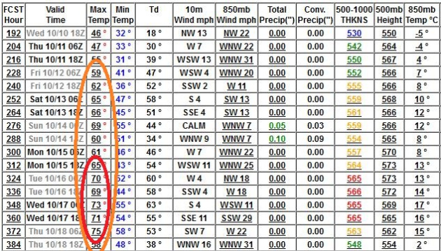
60-degree highs return late next week, a few 70-degree highs after October 15. More mild days ahead.
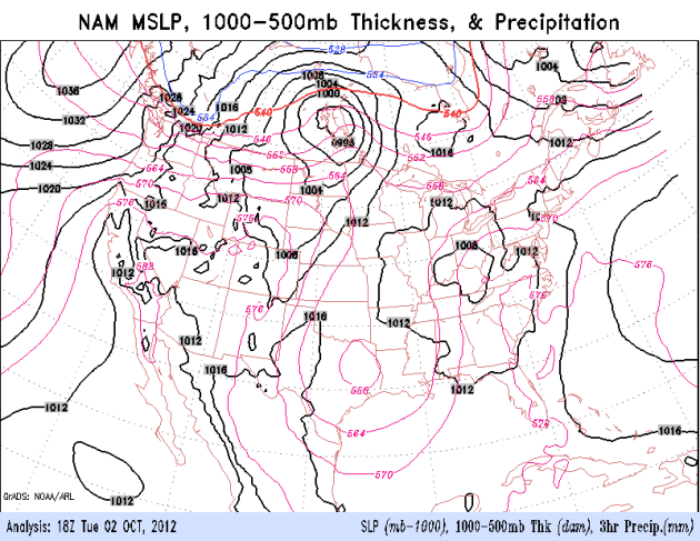
Minnesota's Weather Story: Fire & Ice:
Fire Weather Watch. Drought, gusty winds, low
humidity and sunshine will all combine to increase the brushfire risk
again today; the watch may be upgraded to a Red Flag Warning, meaning a
critical fire risk. More from NOAA:
...FIRE WEATHER WATCH FOR AREAS SOUTH OF INTERSTATE 90 FOR
WEDNESDAY AFTERNOON AND EARLY EVENING FOR STRONG WINDS...AND VERY
DRY HUMIDITY VALUES ONCE AGAIN...

.ON WEDNESDAY...A STRONG COLD FRONT WILL MOVE EASTWARD TO THE NEAR
JAMES RIVER VALLEY BY LATE AFTERNOON. BEHIND THE FRONT...WINDS WILL
BECOME NORTHWEST AND WILL BE VERY STRONG...AVERAGING 25 TO 45 MPH IN
SOUTH CENTRAL SOUTH DAKOTA. THIS WILL BE COUPLED WITH HUMIDITY VALUES
FALLING TO NEAR 25 PERCENT. AHEAD OF THE FRONT... THE WINDS WILL BE
FROM THE SOUTH ROUGHLY FROM AREAS AROUND YANKTON AND POINTS EASTWARD.
THE SOUTHERLY WINDS WILL AVERAGE 15 TO 30 MPH THROUGH THE
AFTERNOON...WITH HUMIDITY VALUES FALLING TO AROUND 18 TO PERCENT.
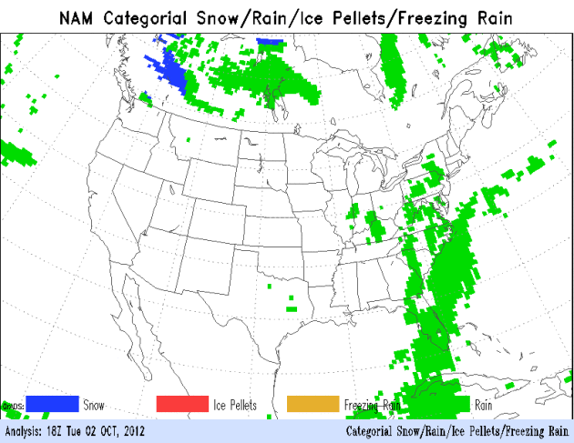
10.4" snow predicted for Grand Forks, North Dakota
Thursday. Data: 18z NAM model using Cobb Method. No, I don't want to
believe it either. Details, and a forecast snowfall map that'll get
snowmobilers excited below.
Rain Changing To (Heavy) Snow Up North. The NAM
model shows a cold rain changing over to snow, heavy at times, over the
Red River Valley Thursday, gradually tapering to flurries on Friday.
Near-blizzard conditions are possible north of Grand Forks late Thursday
into Friday morning. Animation: NOAA.
“
We believe that there will be an El Niño, but the strength of it
is debatable, and it may be a fairly weak one,” said Huug van den
Dool, a meteorologist at the federal government’s Climate Prediction
Center." - from a New York Times article, details and links below. Image above: NOAA.
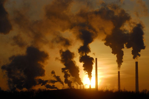
$1.2 trillion. A
recent study
estimated that climate change is already costing the world over a
trillion dollars a year, reducing the world's GDP by 1.6% a year.
"Athena, Brutus and Ceasar". Proposed names for
first 3 major blizzards of 2012-2013 winter season. The Weather Channel
will begin naming blizzards this winter, according to a
USA Today article. The Detroit Free Press has another angle
here. Photo credit above: "
Several decades after hurricanes first got formal names, some blizzards in the U.S. this winter will get their own names." AP Photo.
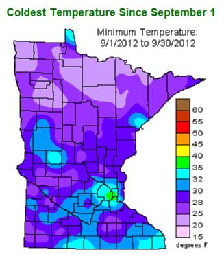
Only Immediate Metro Is Still Frost-Free. According to
NOAA,
only eastern Hennepin, Ramsey and a small portion of northern Dakota
county has avoided a frost so far this autumn, glaring evidence of the
"urban heat island"; asphalt and other man-made surfaces absorbing the
sun's energy during the day, and re-radiating that warmth at night,
keeping temperatures a few degrees warmer than outlying suburbs.
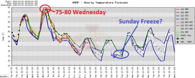
The Big Slide. A nearly 50 degree temperature
tumble? Models push the mercury into the mid and upper 70s tomorrow;
I wouldn't be surprised to see an 80-degree high close to home. Come to
think of it, nothing would surprise me much anymore. We cool down
rapidly Thursday, with the coldest weather forecast to come Saturday and
Sunday morning. By Sunday even the close-in suburbs will have probably
seen the first frost/freeze of autumn. Graphic: Iowa State.
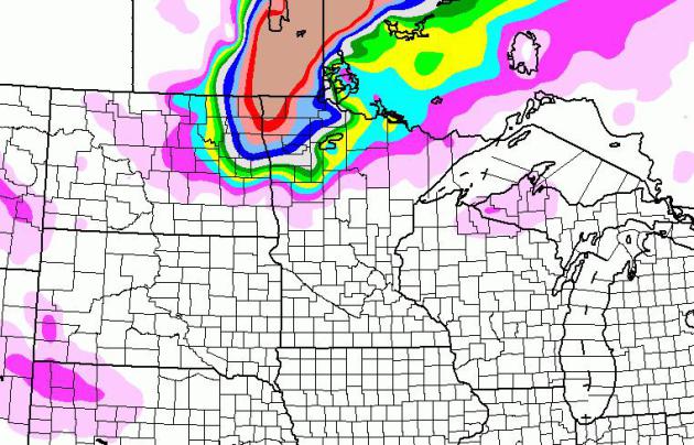
Plowable Snow For Red River Valley? The 84-hour
NAM model prints out a few inches of slushy snow for Hallock and Roseau,
possibly even enough to shovel and plow over far northwestern Minnesota
by Thursday night. The bulk of the wet snow comes during the day
Thursday. International Falls may pick up an inch or two, but the latest
Cobb calculations show
10.4" for Grand Forks. A cool 10-14" may pile up over far northwestern MN. Insert long, drawn-out gasp here.
First Wintry Sneeze. A sharp contrast in temperature
will spin up the first (major) winter storm of autumn over the Red
River Valley, a tight pressure gradient (sharp contrast in atmospheric
pressure) whipping up 30-45 mph winds by Thursday night. I could
envision white-out conditions near Roseau and Hallock, possibly Thief
River Falls, with a couple inches from Bemidji to International Falls.
Within 24-36 hours far northwestern Minnesota may resemble something out
of early January. Elsewhere dry weather prevails, spotty showers over
New England, thunder for Florida, dry weather out west, and a
November-like airmass pushing southward out of Canada into the Northern
Rockies and Northern Plains. 84-hour NAM loop: NOAA.
Big Ups And Downs - Still No Rain. Any rainfall
amounts will be minimal over the next 1-2 weeks, a chance of windblown
(rain) showers in the metro Thursday as much colder air arrives. We dry
out Friday, a few sprinkles (or flurries) possible Saturday, as far
south as the MSP metro. Temperatures Saturday may not climb out of the
30s (north) and low 40s (southern MN) with some moderation Sunday under a
sunnier, kinder sky. 50s return next week, even a few days topping 60s,
according to ECMWF guidance above.
Indian Summer! Yes, it's going to get cold by Friday
and Saturday, but we will warm up again after October 12, by the end of
next week highs should be surging into the 60s, with a few 70s
predicted by the GFS after October 15. The long-range models are fairly
consistent with this mid-month warming, so I suspect it's real.
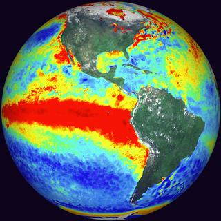
Experts See Signs Of El Nino, But A Weak One. As I
mentioned a few weeks ago in the weather column and blog, recent El
Nino's have focused on the Mid Pacific, not the waters of the Eastern
Pacific. This trend, in turn, has had little impact on Minnesota's
weather, with a wet bias for the Pacific Northwest and the Southeastern
USA. Right now the smart money is on a wetter winter for the south,
possibly the east coast, but the possible impact on the Upper Midwest is
very much up in the air. Here's an excerpt of a
New York Times article: "...
But
after seeing signals for months that a moderate Niño might be arriving
right about now, the more likely case appears to be an episode that is
weak indeed: probably short, and hardly nasty or brutish. Scientists
who predict the weather months in advance pay close attention to
back-and-forth swings in what they call El Niño Southern Oscillation,
or ENSO, which includes the mirror-image oceanic cooling called La Niña
that probably made the past year’s drought worse. And recently they
have been peering at their computer models from the edge of their
seats, eager to detect the latest change."
Pray For Rain. Here are some interesting facts and statistics, related to the drought's impact on the U.S. economy, from
National Journal: "...
A
brutally persistent drought across the Midwest is exacting a toll on
U.S. growth, the Commerce Department confirmed on Thursday. The
department revised its estimate of second-quarter growth for this year
down to 1.3 percent from 1.7 percent. Half the drop came from plunging
farm inventories due to crop loss. You don’t need to parse those stats
to see drought effects across the economy now. You just need to shop
for groceries. Prices are rising for grains and grain-fed livestock;
last month’s producer-price index showed a whopping 23 percent jump in
the price of eggs. The longer those effects persist, the worse the
outlook for the U.S. economy."
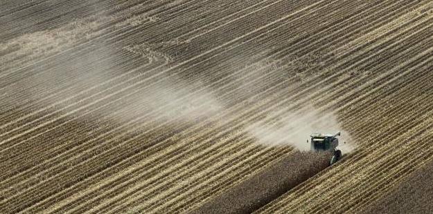
Photo credit above: AP Photo/Danny Johnston. "
In this Aug. 16, 2012, file photo, dust is blown from behind a combine harvesting corn in a field near Coy, Ark."
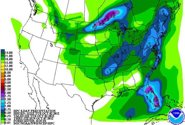
5-Day Rainfall Prediction. Heavy showers and
T-storms are likely over Florida, rain slowly tapering across New
England. Some of the 1"+ precipitation predicted for northern Minnesota
will fall as heavy wet snow Thursday. Yep, it's time. Map: NOAA HPC.
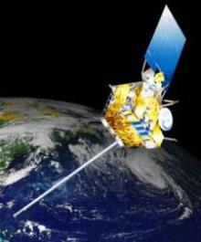
NOAA Moves GOES-14 Farther East As Possible Replacement For GOES-13.
Out of the blue, GOES-13 went wonky a few weeks ago, leaving
forecasters partially blind to spot developments over the central and
eastern Atlantic.
NOAA
reports on how a replacement/back-up satellite, GOES-14, is being
rushed into position to take over for GOES-13; here's an excerpt: "
Engineers
began moving NOAA's GOES-14 weather satellite farther east, to
possibly replace the GOES-13 spacecraft. During the last week of
September, the spacecraft, experienced technical problems with two key
instruments critical for weather forecasting. When the sounder and
imager instruments on GOES-13, which had been NOAA's geostationary
operational environmental satellite over the U.S. East Coast, were
turned off September 23, the agency immediately configured GOES-15, the
West Coast satellite, to provide additional coverage of the eastern
United States and part of the Atlantic Ocean. Within a few hours, NOAA
then activated its on-orbit spare satellite, GOES-14, for full
service. Also, NOAA used data from the METEOSAT-9 satellite of its
European partner, EUMETSAT."
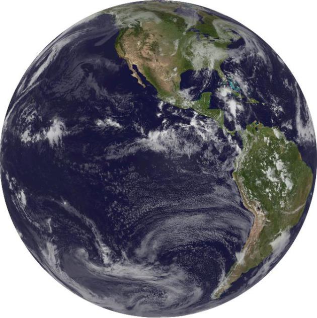
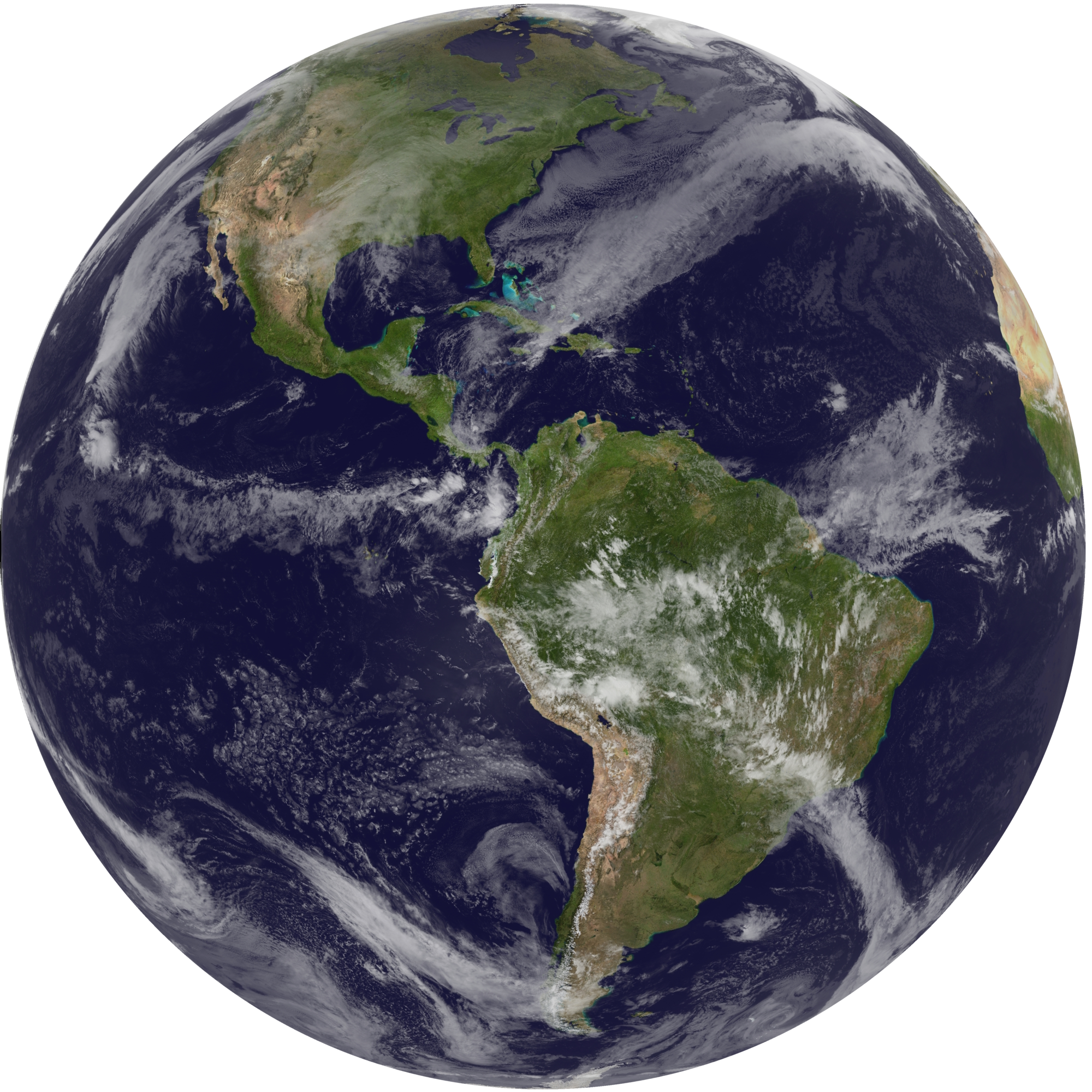
Full Earth Disk. NOAA has the latest image available from GOES-14 available
here.
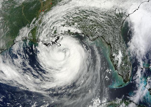
New Hurricane Chief Offers 5 Lessons From This Season. A lot of people underestimated Isaac - no question. Here's an excerpt of a timely article at
Sun-Sentinel.com: "
Despite
early and frequent warnings, the strength and breadth of a tropical
storm's fury often shocks residents, as evidenced last month when Hurricane Isaac dumped as much as 17 inches of rain over western Palm Beach County before hitting Louisiana. Rick Knabb, new director of the National Hurricane Center,
hopes to change that by spelling out the dangers in simpler terms and
with more detailed graphics. Eventually, the agency will be issuing new
products and services, if only on an experimental basis. "Our top
priority is to make sure people understand the various hazards that
hurricanes and tropical storms pose — and what their particularly
vulnerability is," he said." Image: NASA MODIS.
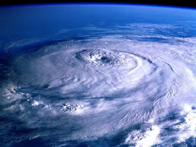
Warmer Oceans: Hurricanes Can Spin Up Faster. Here's a clip from
Earth Guage, part of the National Environmental Education Foundation: "...
How
quickly a hurricane converts the heat energy at the surface of the
ocean into energy of motion in the form of winds plays a major role in
determining how fast winds will be when the hurricane makes landfall. As
Earth’s oceans have warmed, this time has been reduced. This trend has
been particularly pronounced in the North Atlantic basin, which has
been the fastest warming ocean basin since the mid-1980s, when
satellites began systematically monitoring hurricanes. The time it
takes storms in the North Atlantic to accelerate from a 74 mile per
hour Category 1 storm to a Category 3 storm with 138 mile per hour
winds has been reduced by 20 hours. " Image: NASA.
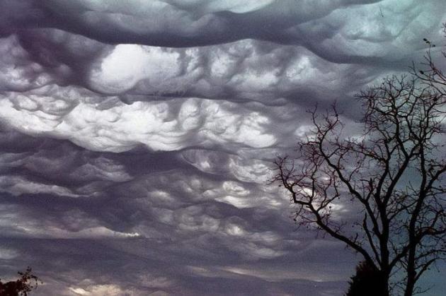
Found: "Species" New Clouds. "Undulatus Asperatus",
if anyone asks. Chances are they won't, but just in case, you'll be
ready, because you frequent this weather blog. Details from
scienceray.com: "...
Undulatus
asperatus will become the first new cloud type to be found since Cirrus
intortus in 1951. “Observing the cloud is important to document the
effects of global warming in the sky. Cloud can give you an answer
about the temperature and climate change in the coming years,” said
Pretor-Pinney. Nowadays, more and more people are interested in watching
the clouds. As an illustration, CAS members numbered 30,903 people.
Next year, the CAS will launch cloud observations app that allows users
to share photographs and location of the cloud. Upload the user can be
used for research activities."
Photo credit above: "
Clouds over Pocahontas, Missouri in "asperatus" or "undulatus asperatus" formation." Courtesy of
Wikipedia.
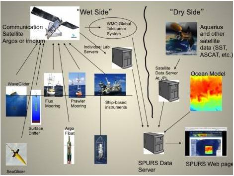
How Is Ocean Salinity Measured? Much of the observed
warming in recent decades is going into the world's oceans, which are
now more acidic than they were 40-50 years ago. This has implications
for coral reefs and marine life.
NASA's Earth Observatory has an interesting (detailed) explanation of how ocean salinity is measured; here's an excerpt: "
Salinity
is a difficult variable to measure properly. It is determined by
measuring the ability of seawater to conduct electricity. Though this
sounds simple in principle, in practice, the measurement of salinity
requires exacting standards of quality. The relevant variations in SPURS
are one part in ten thousand (for comparison, a pinch of salt in a
gallon of water changes its salinity by about 2 parts in ten thousand).
Our instruments can measure salinity differences down to a few parts in
a million."
We have a mobile theme going today....
Will Mobile's Massive Growth Ever Equal Real Revenue? Here's are a couple of excerpts from an eye-opening article at
AdAge: "...
If
publishers once lamented that offline dollars turned into "digital
dimes" as content and audiences moved to the web, here's what might be
keeping them up at night: Digital dimes are turning into mobile pennies.
The effective cost per thousand impressions on the desktop web is
about $3.50, according to data crunched by Mary Meeker, partner at
Silicon Valley venture-capital firm Kleiner Perkins Caufield &
Byers. On the mobile internet? A whopping 75¢...The ad experience on
mobile phones is challenging for a number of reasons. The smaller
screen sizes make most ads unattractive, privacy settings restrict
targeting and short user sessions make providing more than one ad in
front of a user nearly impossible."
Behind The Surge In Mobile News Users. Here's a clip from an interesting article at
Media Life Magazine: "...
We
also know from our research that news is a social activity. People get
news in part, often in significant part, because they enjoy talking
about the world around them with family and friends. I think when that
happens, and people have a smartphone or tablet in their hands, they go
deeper. Questions come up. They answer them, whether it is video of
what a politician did, or some stats about the game, or reading a story
about the day’s events. It is right at hand. What is so interesting is
that the more devices people have, the more they are simply adding
this consumption to their days. They spend nearly equal amount of time
on their desktops getting news as their tablets. And if they own a
smartphone, that time is nearly equal. And if they get a print
newspaper or magazine, that time is roughly equal as well. More devices,
more platforms, simply equates to more consumption."
What Mobile Means For Journalism. In an era of Twitter-fed, instant gratification news nuggets, how does journalism stay relevant in a mobile world?
Personalized. Customized. Convenient. Here's an excerpt of a thought-provoking article at
Forbes: "
Journalism
in the digital era requires disruptive business models. Dispensing
with satellite transmission and truck delivery in favor of wi-fi on
planes may be part of it. So is finding a scalable model for publishing
quality content that satisfies the voracious appetite of digital news
consumers. Then you have to match the cost of producing it with what
marketers are willing to pay. Most traditional media companies still
struggle with century-old, bureaucratic editorial processes better
suited for older technology. Many romantically cling to high-cost
newsrooms built for a different economic and advertising climates."
What To Expect From The iPad Mini. Details from
gizmag.com: "
A
smaller iPad is coming. For the first time since the iconic tablet's
launch in 2010, Apple is giving the product line an expansion. According
to Fortune, we even know the date that Apple will send out its invitations: October 10."
* Gizmodo.com has more on the swirling iPad Mini rumors
here.
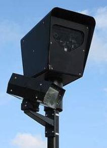
Red-Light Cameras Help Cash-Strapped Cities. Have
you gotten a ticket from one of these automated cameras? They're turning
into a lucrative source of new funding for cities from coast to coast,
as reported by
CNBC.com; here's an excerpt: "...
As
cash-strapped municipalities grapple with reduced budgets, more local
governments are turning to unmanned cameras to help patrol traffic. In
addition to American Traffic Solutions, competitors include Redflex Traffic Systems and Jenoptik.
While the cameras are intended to enforce traffic safety, it's no
secret local governments are also looking to reduce operating costs
with the cameras, said James Tuton, co-founder and chief executive of
American Traffic Solutions. The cameras and subsequent traffic tickets
help reduce violations. "Ninety percent of all people who get tickets
don’t get another one. People don't run red lights when they know there
is a red-light camera," Tuton said. The new technology also pulls in
revenue from traffic fines—without having to pay for an officer's
salary or benefits." File photo: Wikipedia.
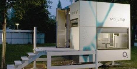
Would You Live In A "Micro-Home"? Tiny homes and
apartments are all the rage in some major urban areas. Why pay for space
you rarely use? Is it a trend or a fad? Here's an excerpt of an article
at
gizmag.com: "...
Micro-dwellings
often seem a mixed salad, combining sweet and bitter together with the
odd flavors of exotic dressings. Micro-dwellings offer the potential
for large, overcrowded cities to bring people closer to their jobs,
reduce the cost of providing infrastructural support to previously
undeveloped areas, and curbing energy usage. However, these potential
benefits come with a sociological price tag. There is little question
that the ambiance of a neighborhood, or that of a building, is likely
to change drastically if the population density increases by a factor
of three to five times." Photo:
treehugger.com.
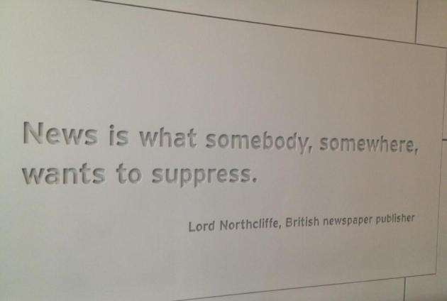
The Power of Free Speech. I snapped this photo at the "
Newseum"
in Washington D.C. Monday. The next time you get to our nation's
capitol check out this (remarkable) museum focused on news-gathering
over the ages. It's right on the Mall, close to the U.S. Capitol.
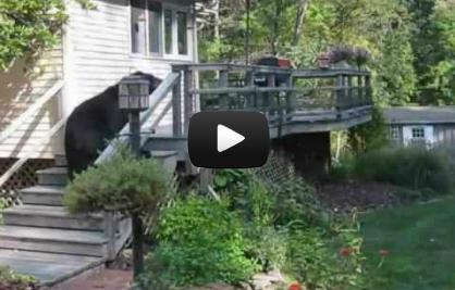
Woman Scares Off Bear By Shouting. Heck, I'd run away too if I heard this. Details (and a compelling, cover-your-ears video clip) from
Huffington Post; here's an excerpt: "
Don't mess with Nishanto Grillo.
This gutsy woman went toe-to-toe with an unwelcome visitor -- a
massive black bear -- and sent the critter on its way with a series of
highly annoyed shouts to leave her property. This isn't the first time
the Grillos have had a burly bear visit their home. A YouTube user named
Nayana Grillo,
who posted the video above on YouTube, has six other videos of a bear
hanging out on the family's deck, much to Nishanto's chagrin."
Still Lukewarm. Temperatures were fairly uniform
across the state yesterday, just about everyone enjoying low 70s under a
partly sunny sky. No rain anywhere - big surprise.
Paul's Conservation Minnesota Outlook for the Twin Cities and all of Minnesota:
TODAY: High brushfire risk. Warm sun. Winds: S 10-15. High: 78
WEDNESDAY NIGHT: Mostly cloudy, showers late - turning colder. Low: 49
THURSDAY: Gusty showers, much cooler. Snow far northwest MN. High: 52
FRIDAY: Partly sunny and brisk. Low: 35. High: 48
SATURDAY: Mostly cloudy, first flakes? Low: 34. High: 43
SUNDAY: Frost/freeze likely. Sunnier, better day. Low: 30. High: near 50
MONDAY: Fading sun, milder breeze. Low: 39. High: 59
TUESDAY: Mix of clouds & sun, turning cooler. Low: 42. High: 55
* we may see a couple of days next week with highs at or above 60 F.
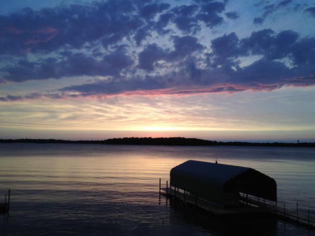
** photo above courtesy of WeatherNation TV meteorologist Aaron Shaffer, who snapped this photo in Shorewood.
Fire and Ice
Your begonias are nervous. Only the immediate
close-in suburbs of Minneapolis/St. Paul have avoided a frost. Thank the
"urban heat island". Asphalt absorbs the sun's radiation and
re-radiates that warmth at night, keeping temperatures consistently 3-8
F. warmer. In fact the growing season in the downtowns is at least 2
weeks longer than the surrounding suburbs. Good news for farmers in St.
Paul
The rumors are true: after peaking in the upper
70s today a series of clippers will sneeze chilly air south of the
border. A frost or freeze is likely this weekend, and this time Edina,
Crystal & Maplewood will wake up to 32 F. or colder. The median date
of the first 32-degree temperature at MSP is October 4, so we're right
on schedule.
Far northwestern Minnesota may pick up a
plowable snow Thursday, and models are hinting at a few early flakes in
the metro Saturday. I doubt anything will stick on your lawn. Last year
the first flurries arrived November 9; 3 weeks later than usual. We'll
see more 60s & 70s by mid-October.
"Brutus, the blizzard?" This winter The Weather
Channel will begin naming U.S. blizzards. I can't wait. No, you can't
make this stuff up.
Climate Stories...
At The Debate: Listen For The Climate Science.
President Obama acknowledges that climate science is real, but offers no
coherent vision of how we can come up with a business-friendly,
economy-jolting strategy to begin dealing with the problem, while
Governor Romney takes an even more cautious approach. He's not denying
the science, but basically saying any solutions are too expensive. I'll
fall off my couch if the subject comes up tonight. Here's an excerpt
from
Huffington Post: "
When
the candidates face off in Wednesday's debate, every word they utter
will be scrutinized for gaffe-ability, flip-floppiness, and
sound-bite-ification. But when it comes to climate change, it's what
they aren't saying that deserves our undivided attention. Even with the
urgent reality of global warming rapidly outpacing scientific
predictions, both candidates have been disturbingly silent about the two
central facts of this immediate, massive, and unprecedented problem.
FACT 1: Climate change is already wreaking havoc in the U.S.
In the past four years, Americans have been struck by a barrage
of climate-fueled disasters. From record heat waves to increasingly
powerful storms, harvest-destroying droughts to unprecedented flooding,
the impacts of climate change are now squarely being felt within our
borders. But neither candidate has "connected the dots" in clear,
straightforward language."
Thousands Make Last Plea To Include Climate Change In Presidential Debate. Details from
The Hartford Guardian.
* make your voice heard at
climatesilence.org.
"
Scientists predicted that if you kept pouring billions of tons of heat trapping gases into the atmosphere, we see more extreme temperatures, bigger deluges, worse droughts and ice melting everywhere. And you don't have to be a scientist to know that these things have all come true. Now scientists are warning if we don't act quickly to reduce carbon pollution, we face even more extreme consequences...."
Joseph Romm
Senior Fellow
Center for American Progress
Editor, ClimateProgress.org
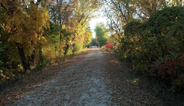
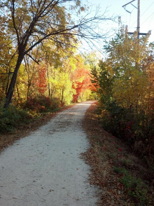
Climate Change Could Delay Fall Foliage Colors (Video). We may be witnessing this trend across the Upper Midwest. Here's an excerpt from a recent story (and video) from
Scientific American: "
Trees
use a combination of cues to determine when to drop their leaves, but
the two primary signals are the length of daylight, and temperature.
Sunlight is the major factor; as trees sense fewer hours of light, they
curtail photosynthesis in their leaves. Green chlorophyll fades, and colors emerge.
Climate change has no effect on day length, but it does on
temperature. If autumn days are warm, trees tend to delay the color
change, and if autumn days are cool, they tend to hasten the pace. If
global temperatures generally rise, you may need to take that walk a
few days later. Indeed, Massachusetts officials have determined that
the average peak color change has shifted about three days later over
recent decades." Photo: WNTV meteorologist Aaron Shaffer.
Military Seeks To End "The Burden" And Create Opportunities.
The U.S. Navy is leading the charge, tapping biofuels to try and become
less dependent on Mideast oil. Here's an excerpt of a story at
getenergysmart.com: "
Vice Admiral Dennis McGinn, USN (ret’d) opens The Burden’s
trailer with these words: "Oil, natural gas, coal have been very good
for the United States …" Key to his words: “have been”. Rich natural
resources have been key to America’s emergence, over the centuries,
into a global powerhouse. Combined with (regulated) capitalism enabling
best practices (mainly) to come to top, freedom of speech within a
democratic society, and an open embrace of people from around the
world, America’s rich fossil fuel resources were critical for U.S.
development: from the coal powering Civil War railroads and steamships,
to America’s oil fueling the Allies in World War II, to the natural
gas fueling chemical industry advances, fossil fuels had a serious role
in making America great."
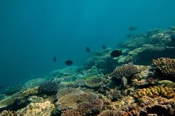
Half Of Great Barrier Reef Lost In Past 3 Decades.
LiveScience.com has the story; here's a snippet: "
Australia's
Great Barrier Reef is a glittering gem — the world's largest coral reef
ecosystem — chock-full of diverse marine life. But new research shows
it is also in steep decline, with half of the reef vanishing in the past
27 years. Katharina Fabricius, a coral reef ecologist at
the Australian Institute of Marine Science and study co-author, told
LiveScience that she has been diving and working on the reef since 1988
— and has watched the decline."
Photo credit above: "
Horseshoe reef before crown-of-thorns invasion." Credit: AIMS Long-term Monitoring Team.
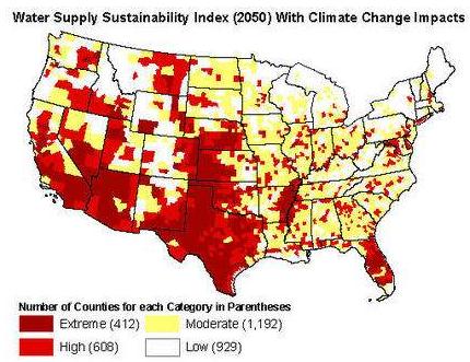
FEMA Must Require States To Plan For Climate Change's Water-Related Impacts.
The most valuable natural resource of the 21st century won't be oil or
natural gas. Water. Here's a clip of a story from NRDC, the Natural
Resources Defense Council: "
And these impacts aren’t going to affect just a couple of states. As a recent NRDC study shows,
a third of all counties in the continental U.S. will face high risks
of water shortages and drought by mid-century as a result of global
warming. It’s critically important that states plan ahead for these
impacts. Natural disasters may not be entirely avoidable, but smart
planning can save both money and lives by making sure that communities
are prepared. The federal government has found
that every dollar it spends on hazard mitigation (in other words,
preparation and planning) provides the nation with about four dollars in
future benefits."
Changing California Climate A Threat To Crops. Much
of America's food is grown in California's Central Valley, so even a
slight temperature spike could make a difference. Here's a clip from
sfgate.com: "
Farmers
have always been gamblers, long accustomed to betting on the
probabilities of the weather. But for the Napa Valley, where
temperatures have been ideal for the wine industry, shifts in the
Earth's climate could be a game-changer. "They're used to rolling the dice every year," said Stuart Weiss, a conservation biologist and chief scientist at the Creekside Center for Earth Observation
in Menlo Park, which assists growers and municipalities dealing with
the disruptions caused by the changing climate. "Now, though, climate
change is stacking the dice." During the next 30 years, Weiss
estimates, the temperature in the Napa Valley will rise by 1.8 degrees -
a significant shift for a wine industry whose product can be affected
by the smallest of temperature changes."
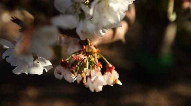
Photo credit above: "
Cherry blossoms at Lodi Farming's orchard show stress because they have not experienced enough "chill hours." Photo: Serene Fang, California Watch / SF
Global Warming Links Democrats, Independents, Isolating Romney. Here's an excerpt from
Bloomberg BusinessWeek: "
Democrats
and independent voters overwhelmingly accept the scientific evidence
that human activity is warming the earth’s temperature, while almost two
out of three Republicans don’t. Among likely voters, 78 percent of
Democrats and 56 percent of independents believe humans are warming the
earth, according to a Bloomberg National Poll. That finding is
consistent with other polls that show undecided voters, and majorities
in contested states such as Ohio and Virginia are in line with President
Barack Obama and most Democratic candidates in wanting to address the
issue."
Think Climate Change Isn't Your Problem? It Will Be When You Can't Eat.
Alarmist? Maybe for the USA (although drought-stricken farmers might
tell you something similar), but for much of the world, where annual
harvests are not taken for granted, there is growing concern about how a
trend toward more extreme heat, drought (and infrequent, but intense
rainfall) will feed the world's growing population. Here's an excerpt
from
The Daily Maverick: "
Climate
change is ravaging the world’s nutritional supplies, and in the very
near future we’ll be looking at astronomical prices for staple foods.
Which will lead to starvation, conflict, and hugely increased
competition for resources. Can we really afford to let that happen? I
recently attended a briefing session of the High Level Panel on the
post-2015 discussion in New York. If I had to measure the urgency of
these discussions against the crisis the world faces, I would be
tempted to jump off a precipice without a parachute. Kumi Naidoo,
Executive Director of Greenpeace, quoted Einstein in that meeting,
saying: “Insanity is doing the same thing over and over again and
expecting different results.” That is precisely what global leaders
entrusted with the stewardship of the world are doing. Their lives
revolve around glittering banquets and long and dreary conferences,
where they listen to each other in endless process-driven negotiations –
so far from the reality of the day-to-day hardships of more than half
of humanity."
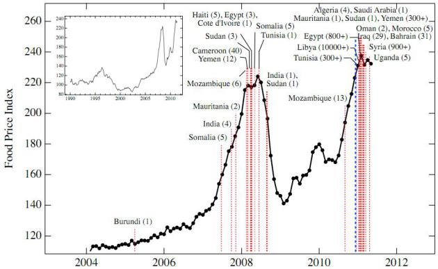
USA Drought Pushing Up Global Food Prices.
Everything is interconnected. Extreme heat and drought in the USA this
past summer is having a domino effect on corn and wheat prices
worldwide, making it impossible for many countries to afford the basics.
Here's an excerpt from a post at
getenergysmart.com: "As to the substance of the video and the linkage between food prices and instability, see this
New England Complex Systems Institute discussion.
This summer’s droughts in the American Midwest have pushed corn and
wheat prices above their previous highs in 2011 and out of the reach of
the world’s poorest, threatening to trigger a new wave of global
unrest — perhaps even a second Arab Spring.
NECSI has shown that
surges in unrest coincided with food price peaks in 2007-01 and 2010-11
[7]. During much of August and September, the price of wheat exceeded
the high of $8.94 of February 2011, by which time the events of Arab
Spring were underway.


No comments:
Post a Comment