52 F. high in the Twin Cities yesterday.
57 F. average high for October 19.
49 F. high on October 19, 2011.
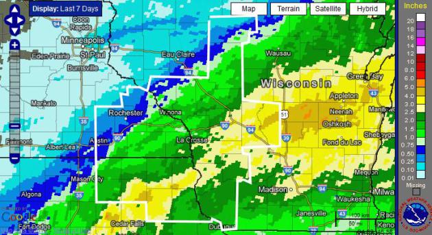
.21" rain fell on the Twin Cities Friday, the biggest 24-hour rainfall since August 15.
4.15" rainfall deficit since September 1.
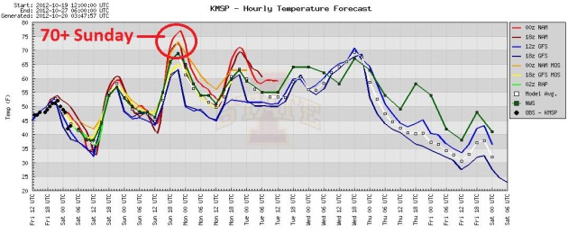
70+ F. highs expected on Sunday, 60-degree highs thru the first half of next week.
30s a week from Sunday? A much colder front is 5-6 days away.
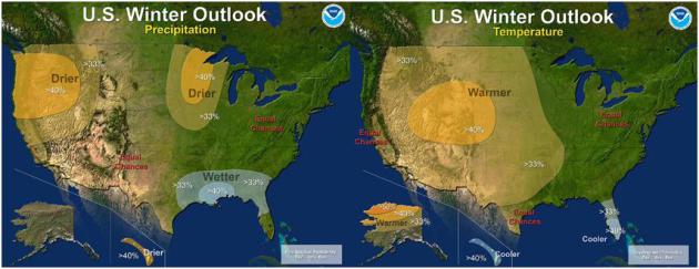
Warmer, drier bias lingering into February for Minnesota? Latest winter outlook from NOAA below.
“
This is one of the most challenging outlooks we’ve produced in
recent years because El Niño decided not to show up as expected,” said
Mike Halpert, deputy director of NOAA’s Climate Prediction Center. - from a NOAA update below.
21 of 28 counties served by the La Crosse, Wisconsin
National Weather Service have been declared Natural Disaster Areas due
to the growing drought. Details below.
"...
Their paper, “The Republicans Should Pray for Rain: Weather,
Turnout, and Voting in U.S. Presidential Elections” confirmed the
conventional wisdom that weather does affect voter turnout, bad weather
benefits Republicans and most interestingly, two presidential
elections in the last 60 years may have had different results had the
weather been different..." - excerpt from a story focused on the
impact of weather on presidential elections over the years, details and
links below. Image above:
venturebeat.com.
Deer-Hunting Opener Outlook? Don't bet the farm on
this one (or any long-range weather forecast, for that matter), but I'll
dial up the GFS details for the first weekend of November below.
Indian Summer Alert. A distractingly nice weekend
is on tap, more typical of early or mid September than late October.
Expect upper 50s to near 60 today; temperatures may top 70 tomorrow,
with highs at or above 60 thru the first half of next week, according
to the ensemble of models above. Graph: Iowa State.
One Wild Weather Ride. After peaking near 70 Sunday,
again Tuesday of next week. Next Wednesday looks like the best chance
of significant rain, even a few heavier T-storms in the area. After a
mild Friday the floodgates open, cold air sweeping into Minnesota next
weekend. The ECMWF (European) model has highs in the 30s a week from
Sunday!
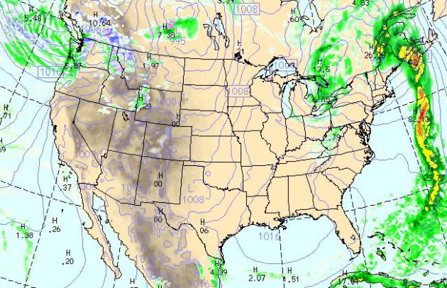
Today's Weather Map. The WRF model shows showery
rains from Detroit and Flint to Buffalo, a soaking rain for upstate
Maine, lighter, showery rains for Seattle and Portland by 4 pm today.
Much of the USA stays dry today.
Elusive El Nino Challenges NOAA's 2012 U.S. Winter Outlook.
The on-again, off-again El Nino warming of Pacific Ocean water is
looking shaky, the odds now close to 50/50, basically a coin-flip. So
NOAA has tweaked the winter outlook from December thru February - here's an excerpt of a longer explanation: "
The
western half of the continental U.S. and central and northern Alaska
could be in for a warmer-than-average winter, while most of Florida
might be colder-than-normal December through February, according to
NOAA’s annual Winter Outlook announced today from the agency’s new
Center for Weather and Climate Prediction in College Park, Md.
Forecasters with NOAA’s Climate Prediction Center say a wavering El
Niño, expected to have developed by now, makes this year’s winter
outlook less certain than previous years.
“This is one of the most challenging outlooks we’ve
produced in recent years because El Niño decided not to show up as
expected,” said Mike Halpert, deputy director of NOAA’s Climate
Prediction Center. “In fact, it stalled out last month, leaving
neutral conditions in place in the tropical Pacific.” When El Niño is
present, warmer ocean water in the equatorial Pacific shifts the
patterns of tropical rainfall that in turn influence the strength and
position of the jetstream and storms over the Pacific Ocean and United
States. This climate pattern gives seasonal forecasters confidence in
how the U.S. winter will unfold. An El Niño watch remains in effect
because there’s still a window for it to emerge..."
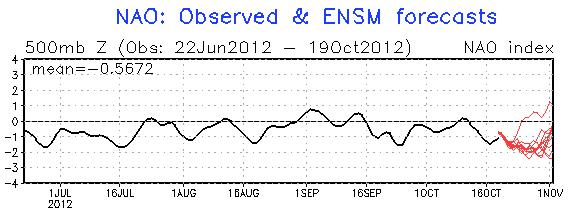
Meteorological Mirage or Reality: Heading Into a Stormier Pattern? When the
NAO
(North Atlantic Oscillation), a measure of the capacity for the
atmosphere to become stuck in a blocking pattern, goes negative, odds of
significant storms tend to rise, especially east of the Mississippi. A
strongly negative signal in late October and early November may signal a
better chance of Gulf moisture reaching Minnesota. I hope it's not
wishful thinking.
Drought Brings Pleas To Cut Back Water Use. Bill McAuliffe at
The Star Tribune takes a closer look at Minnesota's growing drought and the potential need for water restrictions; here's an excerpt: "
With
rivers and rainfall approaching record low levels, state officials
said Thursday they want homeowners to eliminate "nonessential" water
use, such as lawn watering and car washing, and have told farmers to
abide strictly by irrigation permits. In parts of the state, some
residential wells have run dry or had flow reduced by commercial and
residential neighbors, said Dave Leuthe, deputy director of Ecological
and Water Resources at the Department of Natural Resources. Continued
lack of rain could prompt the DNR, under terms of a drought action
plan, to require specific water conservation targets for users,
particularly cities. In recent weeks it has suspended 50
permits for surface water use by businesses, golf courses and parks
departments across the state, though many have backup water sources..."
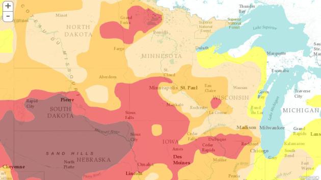
Infographic map details above: "
The
map below is based on data released each Thursday at 8:30 a.m. Eastern
Time. The drought monitor combines numeric measures of drought and
experts' best judgment into a weekly map. It is produced by the NDMC,
the U.S. Department of Agriculture and the National Oceanic and
Atmospheric Administration and incorporates review from 300
climatologists, extension agents and others across the nation. Each week
the previous map is revised based on rain, snow and other events,
observers' reports of how drought is affecting crops, wildlife and other
indicators."
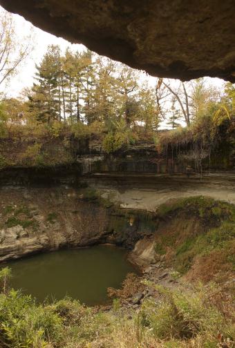
Minnehaha "Falls". Lakes, rivers and streams are at
historically low levels across much of Minnesota; here's a photo from
Jeff Wheeler at The Star Tribune that sums up the state of our
weather: "
Step into Minnehaha Creek this fall and your feet won’t
even get wet.And the thundering waterfall? Just a drip.With little rain,
flow dwindled in late summer, and the dam that releases water from Lake
Minnetonka into the creek was closed Aug. 20 to maintain the lake’s
level.(Dam closings have happened before.) Contrast the gravel-bed look
of today with June 2011, left,when heavy rain caused streams to swell
near flood levels. The dangerous,muddy conditions didn’t keep tourists
from venturing near the falls."
Drought Killing Young Trees Over Southeastern Minnesota. Here's an excerpt of a post from the
La Crosse, Wisconsin office of the National Weather Service: "...
Drought impacts include:
- River flows are well below normal. The flows were less than 20 percent of normal along the Bloody Run, Cedar, Little Cedar, Mississippi, Root, Turkey, Upper Iowa, Volga, and Zumbro South Fork.
- Record low ground levels have been established within the past month near
El Dorado, IA in Fayette County (17.33 feet below ground on September
23, 2012 - the previous record was 17.11 feet on February 6, 2009) and
Fort McCoy Military Reservation in Monroe County (9.15 feet below
ground on October 12, 2012 - the previous record was 8.62 feet on
October 7, 1987).
- Some young trees have died. Young and recently planted trees died in Winona County in southeast Minnesota and Monroe, Adams, and Juneau counties in Wisconsin.
- 21 of our 28 counties have been declared Natural Disaster Areas. This includes: Allamakee, Chickasaw, Clayton, Fayette, Floyd, Howard, Mitchell, and Winneshiek counties in northeast Iowa; Fillmore, Houston, and Mower counties in southeast Minnesota; and Adams, Clark, Crawford, Grant, Jackson, Juneau, La Crosse, Monroe, Richland, and Vernon counties in western Wisconsin."
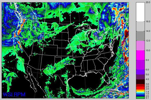
72 Hour Rainfall Forecast. WSI's RPM model (through
Monday evening) shows the heaviest rains and mountain snows over the far
west, a couple feet of snow possible for the Cascade Range of the
Pacific Northwest. A little light rain spreads across the Upper Midwest
by Monday, harbingers of larger storms to come by the middle of next
week.
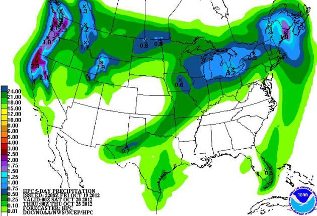
QPF. NOAA HPC's 5-day rainfall outlook shows
significant rain from the Great Lakes into northern New England, some
2-4" rainfall amounts from northern California into the Pacific
Northwest.
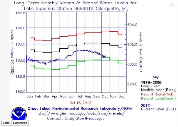
Low Water Levels on Lake Superior. Here's a post from the
Marquette office of the National Weather Service, via FB: "
You
may have heard that the Great Lakes water levels are below normal.
According to the U.S. Army Corps of Engineers, as of October 17, 2012,
Lake Superior was at 600.69 feet, which is 1.41 feet below the
long-term average of 602.1 ft and 0.1 feet below the all time record low
for October of 600.7 ft set back in 1925. The other Great Lakes are
also below normal and very near the all time record lows for October.
Mean levels are calculated by averaging the best available guage data at
report generation and are subject to change."
Will The Weather Determine The Next President? Here's an excerpt of a fascinating post at
ThorntonWeather.com: "
Looking
back at presidential elections from 1948 to 2008, the study takes into
account the weather in 3,000 U.S. counties. They in turn looked at
key areas of the nation and how weather, good and bad, affected voter
turnout. In the end, the study determined that precipitation is the
key weather condition to affect voter turnout.
In part, the study says:
We find that rain
significantly reduces voter participation at the polls by a rate just
under one percent per inch. Snowfall also decreases turnout, but only
in rural counties. Moreover, we show that the estimated number of
voters lost due to precipitation significantly benefits the Republican
Party’s vote share and GOP incumbents particularly.
According to the study, if there was an inch of rain more than
normal in a given area, nearly 1 percent fewer voters turned out and
the Republican presidential candidate received an extra 2.5 percent of
the vote. For every inch of snow above normal, overall voter turnout
was depressed by 0.5 percent and the Republican candidate’s vote share
increased by 0.6 percent."
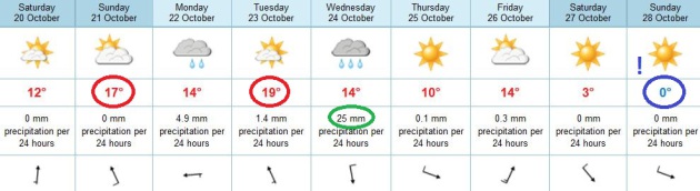
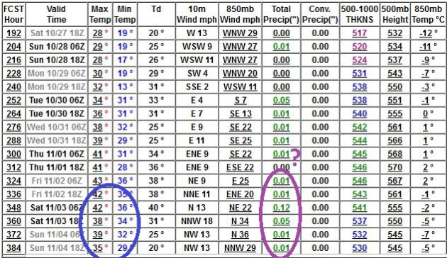
A Chilly Hunting Opener? The extended GFS model
shows highs in the 30s and 40s the first weekend of November, with a few
tenths of an inch of precipitation. 850 mb temperatures range from -2
to -7 C, cold enough for wet snow, or possibly a rain-snow mix. Although
I don't see a heavy snow accumulation for the metro (yet) I could
envision some slush on the ground for tracking up north. Stay tuned...
Could A Hurricane Ever Strike Southern California?
With warming oceans the idea isn't as far-fetched as it might sound at
first blush. Tropical storms have struck San Diego and L.A. before, a
long time ago, so the odds aren't zero, but California residents
probably shouldn't lose much sleep over this. Here's an excerpt of a
NASA JPL story: "
There's
an old adage (with several variations) that California has four
seasons: earthquake, fire, flood and drought. While Californians
happily cede the title of Hurricane Capital of America to U.S. East and
Gulf coasters, every once in a while, Mother Nature sends a reminder to
Southern Californians that they are not completely immune to the whims
of tropical cyclones. Typically, this takes the form of rainfall from
the remnants of a tropical cyclone in the eastern Pacific, as happened
recently when the remnants of Hurricane John brought rain and
thunderstorms to parts of Southern California. But could a hurricane
ever make landfall in Southern California? The answer, as it turns out,
is yes, and no. While there has never been a documented case of a
hurricane making landfall in California, the Golden State has had its
share of run-ins and close calls with tropical cyclones. In fact,
California has been affected by at least a few tropical cyclones in
every decade since 1900. Over that timeframe, three of those storms
brought gale-force winds to California: an unnamed California tropical
storm in 1939, Kathleen in 1976 and Nora in 1997. But the primary
threat from California tropical cyclones isn't winds or storm surge.
It's rainfall -- sometimes torrential -- which has led to flooding,
damage and, occasionally, casualties..."
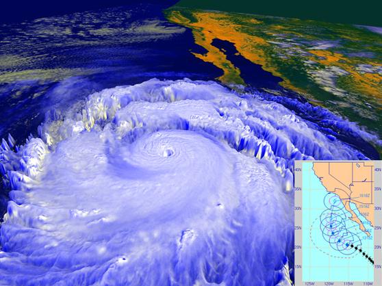
Image credit above: "
In September 1997, powerful Hurricane
Linda, shown in this NASA rendering created with data from the NOAA
GOES-9 satellite, was briefly forecast to strike Southern California,
most likely as a tropical storm, as shown in the inset forecast track
from the Naval Research Laboratory’s Marine Meteorology Division. The
storm eventually turned westward away from land, but still brought
rainfall to parts of Southern California and high surf." Image credit: NASA/NOAA/NRL
Study Shows How Prayer, Meditation Affect Brain Activity.
I'm always on the lookout for stories, photos and commentary that make
me do a double-take. Here's one that fits the bill from
Huffington Post: "
How does prayer and meditation affect brain activity? Dr. Andrew Newberg, MD
is the Director of Research at the Myrna Brind Center for Integrative
Medicine at Thomson Jefferson University Hospital and Medical College
and he has studied the neuroscientific effect of religious and spiritual
experiences for decades. In a video that recently aired on "Through the Wormhole"
narrated by Morgan Freeman on the TV channel Science, Dr. Newberg
explains that to study the effect of meditation and prayer on the
brain, he injects his subjects with a harmless radioactive dye while
they are deep in prayer / meditation. The dye migrates to the parts of
the brain where the blood flow is the strongest, i.e,. to the most
active part of the brain..."
"The Lost Wheels" on TPT Almanac. If you missed the live show Friday evening on KTCA, Channel 2, you can watch the replay
here.
I babbled on about the drought, but the highlight of the show (for dear
old dad) was seeing my oldest son play lead guitar for an up and coming
Twin Cities band. Am I a little biased? Yep, but I know good music when
I hear it. You can hear some of the tracks on their new CD, "Chipper"
at their
home page. Hey, I'm hoping Walt supports me in my old age!
October 19 Weather Highlights. Information courtesy of the KMPX National Weather Service:
2000: Warmest October 19th in
Minnesota history. Many cities had highs in the 80s, with the Twin
Cities hitting 84 degrees. Appleton in Swift County reported 90 degrees.
2000: Warmest October 19th in
Minnesota history. Many cities had highs in the 80s, with the Twin
Cities hitting 84 degrees. Appleton in Swift County reported 90
degrees.
1972: Cold Snap. 1 above in Tower. 9 in St Peter and Luverne.
1916: Redwood Falls received a record-setting 7 inches of snow.
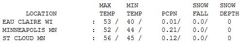
A New Concept: "Rain". A total of .21" of rain fell
on the cities yesterday, the greatest single-day rainfall since August
15, when .73" rain fell on the metro area. Showers gave way to some sun
by afternoon, highs ranging from 45 at Redwood Falls to 52 in the Twin
Cities to 56 at St. Cloud.
Paul's Conservation Minnesota Outlook for the Twin Cities and all of Minnesota
TODAY: Mix of clouds and sun, near normal temperatures. Winds: S 5-10. High: 57
SATURDAY NIGHT: Clear to partly cloudy skies. Low: 46
SUNDAY: Leaf Raking Alert. Indian Summer with plenty of lukewarm sunshine. Winds: S 10-15. High: near 70
MONDAY: Increasing clouds - a little light rain late. Low: 50. High: 66
TUESDAY: Mostly cloudy, mild & humid. Low: 52. High: 67
WEDNESDAY: Showers, risk of thunder. Low: 54. High: 69
THURSDAY: Sun returns, turning cooler. Low: 51. High: 55
FRIDAY: Intervals of sun, quiet weather. Low: 41. High: 57
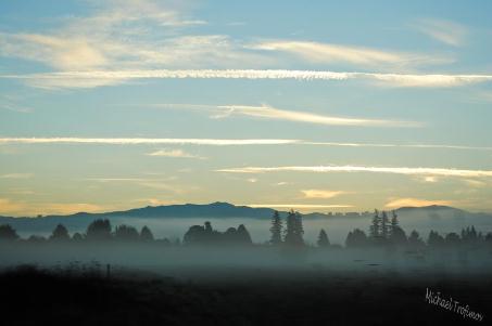
* photo above courtesy of Michael Trofimov, a prolific weather enthusiast in Battle Ground, Washington.
Land of 9,000+ Lakes
It's all "weather-hype" until the water stops
coming out of your faucet. Based on DNR warnings I sense we're close to
water restrictions, and no wonder. With a 4-5" shortfall since
September, many towns have missed the equivalent of 2 month's worth of
rain.
Lake, river & stream levels are approaching
historic levels. After a wet spring rainfall went over a cliff. Record
summer heat increased evaporation, accelerating water loss and drying
out Minnesota's topsoil.
Recent rains have helped a little over far
western Minnesota, but NOAA's revised winter outlook shows a dry bias
lingering into February.
So as excited as I am about a welcome rerun of
Indian Summer, I'd be thrilled to be tracking a sloppy, southern
"storm". Skies clear today, 60s likely much of next week; 70 F not out
of the question. Some light rain is expected Monday, Wednesday, again
next weekend - before it cools off in time for a chilly Halloween. At
this rate drought may be the Big Story into 2013.
Today's weather blog includes a Hunting Opener
Outlook (guess), and why Republicans may be praying for a wet, stormy
Election Day.
Yes, there seems to be a real correlation between weather and voter turnout.
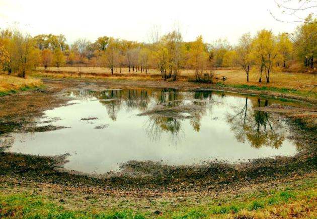
* photo above courtesy of
WeatherNation TV meteorologist Todd Nelson, who writes: "...
this
is a little pond on the northwest side of town (St. Michael) that I
pass by, which is VERY low. I've never seen it this low before..."
Climate Stories...
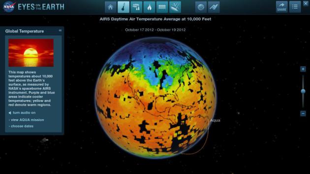
Eyes On The Earth.
NASA
has impressive on-line tools to be able visualize Earth's morphing
climate, including real-time global tracking of carbon dioxide and
carbon monoxide (showing huge plumes of pollutants sweeping across China
into the Pacific). The map above shows global temperatures from Friday.
By downloading a JAVA applet you can manipulate all these data sets in
3-D. Very cool.
Why The Chill On Climate Change? Here's an excerpt of a thoughtful (on the money) Op-Ed at
The Washington Post: "...
Why
does it matter that nobody is talking about climate change? Because if
you accept that climate scientists are right about the warming of the
atmosphere — as Obama does, and Romney basically seems to as well —
then you understand that some big decisions will have to be made. You
also understand that while there are some measures the United States
could take unilaterally, carbon dioxide can never be controlled without
the cooperation of other big emitters such as China, India and Brazil.
You understand that this is an issue with complicated implications for
global prosperity and security. A presidential campaign offers an
opportunity to educate and engage the American people in the decisions
that climate change will force us to make.
Unfortunately, Obama and
Romney have chosen to see this more as an opportunity to pretend that
the light at the end of the tunnel is not an approaching train."
Climate Change: Journalism's Never-Ending Fight For Facts. Here's an excerpt of a story at
The Guardian's Environment Blog: "
The debate about climate change
is dogged – possibly even defined – by its interminable, intractable
tug of war over the "facts". A hand grenade is lobbed into no-man's land
triggering a volley of return fire. But, when the dust settles, can
anyone truly claim to have advanced their position? Of course, the art
of "manufacturing doubt"
has long been in the playbook of those hoping or needing to divert
attention away from evidence. We saw it a generation ago with smoking,
just as we see it today with climate change. But knowing how this
blatant tactic is deployed doesn't make it any easier to nullify or
deter. Compounding the problem is the speed at which "facts" can now
spread unchallenged across the internet. Rebutting or contextualising
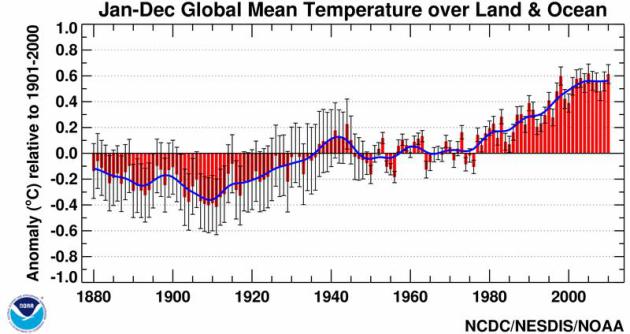
inaccuracies takes expertise and, above all, time and energy..." Graphic above: NOAA NCDC.
The Sad History Of Climate Policy, According to David Brooks. Here's a clip from an important Ezra Klein Op-Ed at
The Washington Post's Wonkblog: "...
So,
to summarize: Addressing climate change by pricing carbon — an idea
Brooks supported then and supports now — was a bipartisan project in
2003. It became a partisan project because Al Gore thought it was
important enough to make a documentary about. Republicans began opposing
efforts to price carbon, in part because they hate Al Gore. That left
funding renewables research as the only avenue for those worried about
climate change. Funding renewables research means funding some projects
that won’t work out, and some that might make Al Gore rich. This led
to bad publicity that tarnished the whole program. The passivity of
Brooks’s conclusion is astonishing. This isn’t a story of overreach,
misjudgements, and disappointment. It’s a story of Republicans putting
raw partisanship and a dislike for Al Gore in front of the planet’s
best interests. It’s a story, though Brooks doesn’t mention this, of
conservatives building an alternative reality in which the science is
unsettled, and no one really knows whether the planet is warming and,
even if it is, whether humans have anything to do with it. It’s a story
of Democrats being forced into a second and third-best policies that
Republicans then use to press their political advantage..."
Photo credit: "
Sorry, planet. You never should have let Al Gore make that documentary." (Joel Boh — Reuters)
* the David Brooks Op-Ed at The New York Times is
here. Subscription may be required.
A Rogue Climate Experiment Outrages Scientists. An attempt at geo-engineering climate (without any permission?) Scientists gone rogue? Here's a clip from a
New York Times article: "
A
California businessman chartered a fishing boat in July, loaded it
with 100 tons of iron dust and cruised through Pacific waters off
western Canada, spewing his cargo into the sea in an ecological
experiment that has outraged scientists and government
officials...Marine scientists and other experts have assailed the
experiment as unscientific, irresponsible and probably in violation of
those agreements, which are intended to prevent tampering with ocean
ecosystems under the guise of trying to fight the effects of climate change..."
Interior Department Creates Climate Change Committee. Here's the intro to a story at
Human Events: "
The
Obama administration is creating an advisory committee on climate
change to advise the federal government on future operations. The
Interior Department announced the new bureaucracy in a recent federal
registry notice along with a call for nominations by Nov. 19 to seat
the 25-member board. The notice specifically states membership will be
comprised of state and local government employees, non-governmental
organizations, Native American tribes, academia, individual landowners
and business interests...."
Extreme Global Warming Caused Devastating Die-Off.
The Christian Science Monitor reports; here's a snippet: "
Feverishly
hot ocean surface waters potentially reaching more than 104 degrees
Fahrenheit (40 degrees Celsius) may have helped cause the greatest mass
extinction in Earth's history, researchers say. "We may have found the
hottest time the world has ever had," researcher Paul Wignall, a
geologist at the University of Leeds in England, told LiveScience. The mass extinction at
the end of the Permian Era about 250 million years ago was the
greatest die-off in Earth's history. The cataclysm killed as much as 95
percent of the planet's species. One key factor behind this disaster
was probably catastrophic volcanic activity in what is now Siberia that spewed out as much as 2.7 million square miles (7 million square kilometers) of lava, an area nearly as large as Australia. These eruptions might have released gases that damaged Earth's protective ozone layer..."


No comments:
Post a Comment