50 F. high Thursday in the cities.
57 F. average high on October 18.
47 F. high on October 18, 2011.
.01" rain in the Twin Cities yesterday.
Lakes and rivers across much of Minnesota at historic low levels.
30% of Minnesota experiencing extreme drought; severe drought now across most of the metro area.
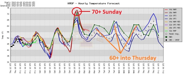
70+ highs possible Sunday, again next Tuesday. Photo: Kayla Rose.
70+ mph wind gusts across the Dakotas yesterday. Details from
NOAA.
Indian Summer Alert. Another cool day is on tap
today with a few showers and highs topping 50. Skies clear Saturday, by
Sunday a south wind tugs the mercury to or above 70 F in the metro.
Sunday is your leaf-raking day. Highs most of next week should reach or
top 60 F, a few degrees above average. Graphic above: Iowa State.
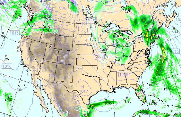
Today's Weather Map. 4 pm today, according to the
WRF model, brings showery rains from Minnesota into the Great Lakes, a
steadier, heavier rain for much of New England. Skies clear across the
East Coast, with lingering T-storms over Florida. Most of the west stays
warm and dry, showers for the Pacific Northwest. Map above: NOAA.
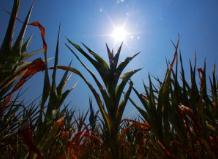
12. 4 days. Midwestern corn planting dates more than 12 days earlier than 1981? "
According
to an Iowa State University Study from 1981 to 2005, The Midwest has
seen its average corn planting date advance by 0.40 days per year and
the average soybean planting date advance by 0.49 days per year." - from a story at the Marshall Democrat-News below. Photo: madison.com.
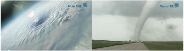
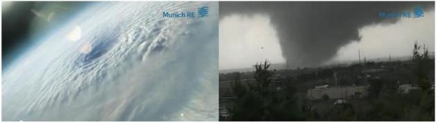
Extreme North America: continent experiencing the
greatest uptick in severe weather, worldwide, according to a new report
from reinsurance giant Munich Re. Details and video links below.
"
Americans’ belief in the reality of global warming has increased
by 13 percentage points over the past two and a half years, from 57
percent in January 2010 to 70 percent in September 2012. At the same
time, the number of Americans who say global warming is not happening
has declined nearly by half, from 20 percent in January 2010 to only 12
percent today." - excerpt from a new report from The Yale Project on Climate Change Communication. Details below.
No Winter Blasts...Yet. We're safe, looking out at
least a week. Yes, we're taking this a week at a time. O.K. One day at a
time. The ECMWF model keeps us sunny and pleasant this weekend, the
best chance of light rain Monday, heavier rain Tuesday night into
Wednesday, followed by a cooling trend late next week. 70 Sunday, again
Tuesday? There's a good shot.
A Mild Bias Into Much Of Next Week. Canada is
pulling it's punch, at least for the next week or so. The core of the
jet lifts farther north, allowing 60s, even a few 70s to push as far
north as Minnesota. The best chance of showers should come over the
northern third of the USA. 192 forecast above courtesy of NOAA.
North America Most Affected By Increase In Weather-Related Natural Catastrophes. Global reinsurance giant Munich Re has produced a
comprehensive video connecting the dots. Within insurance (and military) circles, there is little ongoing "debate" about the science: "
A
new study by Munich Re shows that North America has been most affected
by weather-related extreme events in recent decades. The publication
"Severe weather in North America" analyzes all kinds of weather perils
and their trends. It reports and shows that the continent has
experienced the largest increases in weather-related loss events."
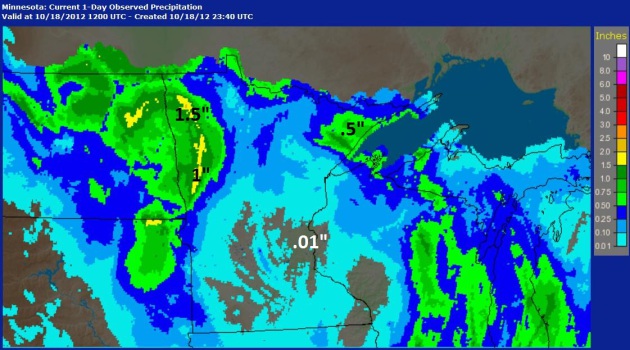
24-Hour Rainfall.
Doppler radar estimates
from the National Weather Service show some .5 to 1.5" amounts over the
Red River Valley and eastern Dakotas, a whopping .01" in the Twin
Cities - in the "eye" of Thursday's storm.
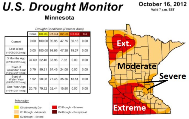
Extreme Drought. Nearly a third of Minnesota is now in extreme drought, the second most severe category from NOAA's
U.S. Drought Monitor,
up from 19% last week. 99.95% of The Gopher State is in a moderate
drought, or worse, with severe drought expanding across the Twin Cities
metro. The map above does not reflect rain that fell yesterday and
today.
DNR Urges Water Conservation Due To Severe Drought. KARE-11 has the story (and video); here's an excerpt: "
The
Minnesota Department of Natural Resources warns Minnesotans to
conserve water, with severe drought now affecting almost half our state
and straining water supply. The entire state is considered to be in
moderate drought. The agency is asking people to stop watering their
lawns and trees or washing their cars. Farmers are asked to stop
outdoor irrigation and businesses should reduce their water use, state
officials say...."
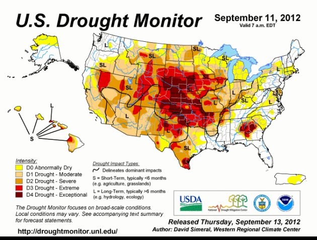
Morphing Drought of 2012. The animation above is a
6-week time lapse
of expanding and deepening drought, from Minnesota southward to Texas,
westward to Nevada. Exceptional drought conditions linger from South
Dakota southward to Oklahoma - much of Georgia is also suffering thru
historic drought.
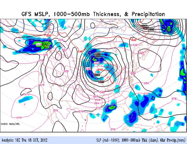
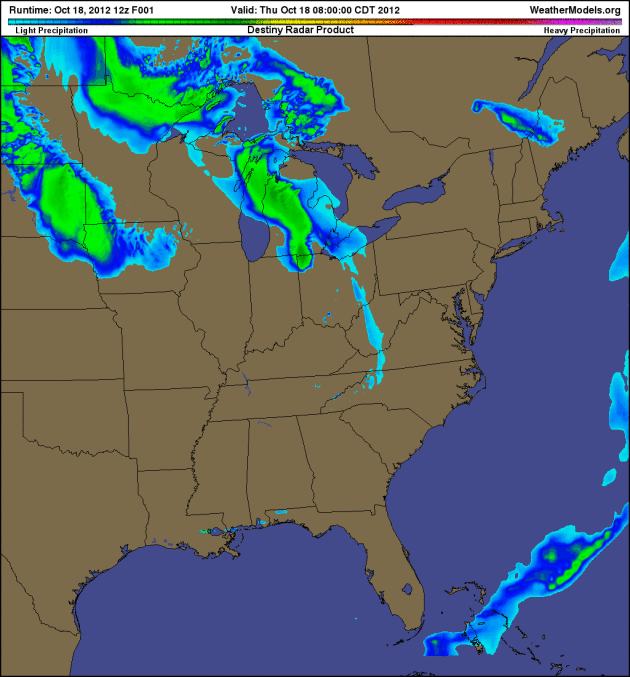
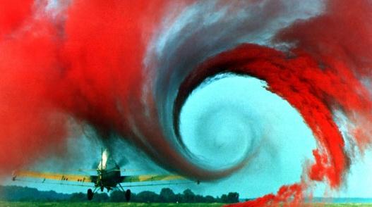
"Eye Of The Storm". Thursday's strong cyclone had an
almost hurricane-like appearance with spiral bands wrapping around a
calm "eye" or center of low pressure close to the Twin Cities. Future
radar (4 km NAM) shows this counterclockwise swirl of moisture
pinwheeling into the Great Lakes; showers and T-storms pushing off the
east coast, a few lingering puddles over Florida. Model data: NOAA and
Ham Weather.
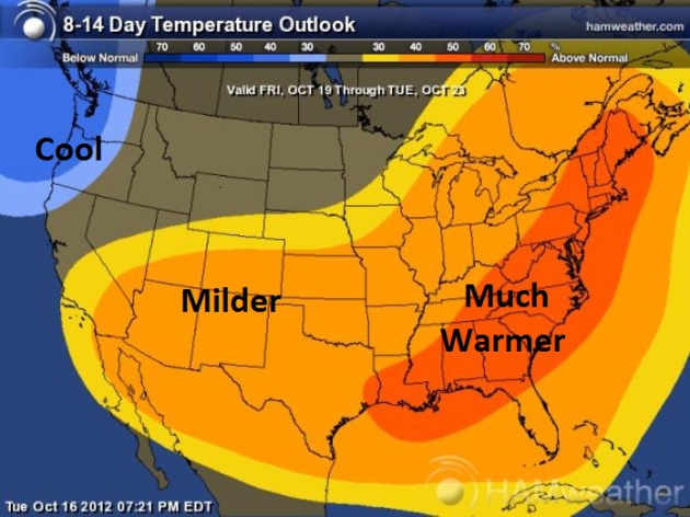
8-14 Day Temperature Trends. According to
NOAA CPC (Climate Prediction Center) there should be a warm bias over
much of the eastern and southern states thru October 23, only the
Pacific Northwest showing cooler than average trends. I expect mild
weather from the weekend into the first half of next week, followed by a
return to chilly weather the end of next week. Map: NOAA and
Ham Weather.
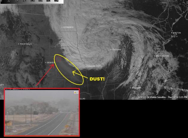
Forecast Calls For Blowing Dust. Drought + dry
topsoil + 50+ mph winds = blowing dust, a mini-Dustbowl effect for the
central Plains on Thursday, a plume of dust showing up on the midday
visible satellite image from NOAA.
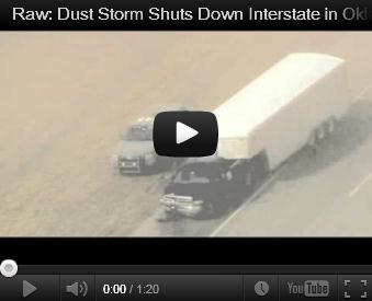
Dust Storm Shuts Down Interstate In Oklahoma. More details in this
YouTube clip: "
A
massive dust storm swirling reddish-brown clouds over northern
Oklahoma triggered a multi-vehicle accident along a major interstate
Thursday, forcing police to shut down the heavily traveled roadway amid
near blackout conditions."
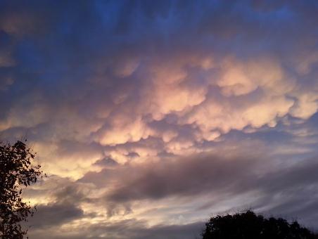
"Mamma". Cumulonimbus mammatus, to be precise -
courtesy of the St. Louis office of the National Weather Service; a
tip-off of possible lightning (and hail) nearby.
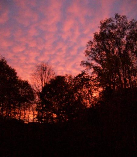
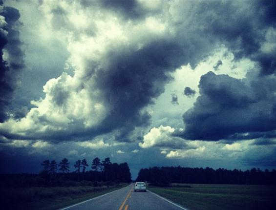
Autumn Twilight. Rose Moore snapped this fine photo
in northeastern Ohio yesterday; she probably had to get out of the house
to escape a blizzard of negative attack-ads on television in one of
America's (unlucky?) swing states.
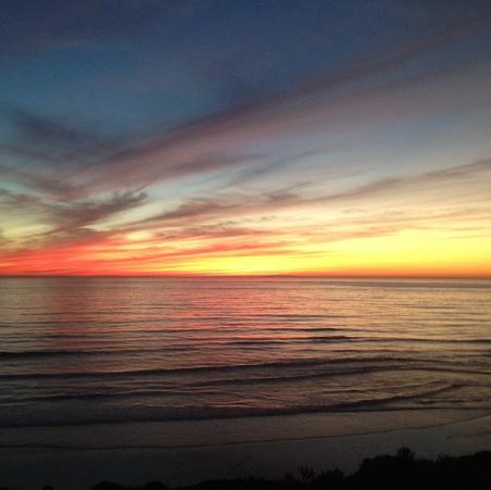
Weather Therapy. This was the scene in Del Mar, California Thursday -
photo courtesy of @peterdohoney.
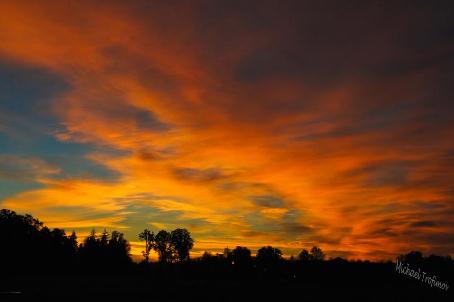
Blazing Cirrus. Michael Trofimov sent us this photo
from Battle Ground, Washington, the setting sun illuminating a smear of
cirrus, ice crystals 25,000 feet above the ground.
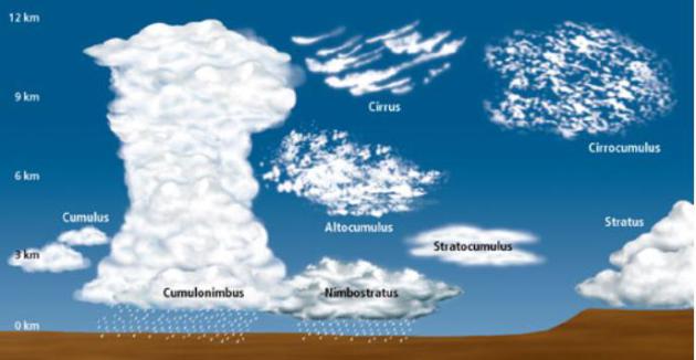
Cloud Classification. The
NWS
in Louisville, Kentucky has a great explanation of cloud types
(classified primarily based on altitude above the ground). Late October
and November tends to bring more nimbostratus and stratocumulus clouds
as the cold winds of winter swirl into the USA.
U.S. Air Force Goes "Vortex Surfing" To Reduce Fuel Consumption. Yes, we have much to learn from nature. Here's a clip of a fascinating article from
gizmag.com: "
The
United States Air Force (USAF) is taking flying lessons from geese and
spiny lobsters. This may seem like the mother of all bureaucratic
errors, but there’s actually some pretty solid science behind it. In
exploiting a phenomenon known as “vortex surfing,” the USAF has found
that by having C-17 cargo planes flying in formation, it can reduce fuel
consumption by up to ten percent...."
One More Reason to Watch Almanac on TPT. Yes, I love
Almanac,
and not because they invite me on to talk about the weather once a
month. It's an hour of news, discussion, laughter, poignant stories,
politics, perspective and analysis every Friday at 7 pm on TPT 2,
KTCA-TV. There's nothing like it on television, an award-winning show
that assumes its audience has some modicum of intelligence. Tonight I
talk about the growing drought, and the in-studio musical group is
The Lost Wheels,
an up and coming Twin Cities band that has a unique sound, a fusion of
rock, blues and funk, with a dash of country. Their lead guitarist looks
vaguely familiar...where have I seen him? Hmm. Hope you can tune in at 7
pm and see for yourself.
A Case For Adult Diapers. I should have my head examined. Last night I toured "
The Haunted Basement"
at The Soap Factory at St. Anthony Main in Minneapolis with friends and
colleagues. You're seen haunted houses before, but you've never seen
anything quite like The Soap Factory. Here's how good it is - 10,000
tickets sold out in 4 hours. Justin Bieber should be so lucky. Plan
ahead for 2013. It's a great way to get into the Halloween spirit. Then
again, if I want to get scared I can just call up my 401K. More like a
101K these days...
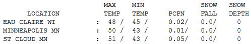
Risk of Jackets. Thursday temperatures were a good
10 degrees cooler than average, the heaviest, steadiest rains over far
western Minnesota. Highs ranged from 47 at Alexandria to 50 in the Twin
Cities, 51 at St. Cloud.
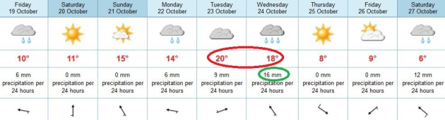
Paul's Conservation Minnesota Outlook for the Twin Cities and all of Minnesota:
TODAY: Mostly cloudy. Cool, raw and showery. Winds: NW 10-20. High: 50
FRIDAY NIGHT: Lingering clouds, a cool wind. Low: 39
SATURDAY: A mix of clouds and sun, a better day. High: 57
SATURDAY NIGHT: Clear to partly cloudy. Low: 44
SUNDAY: Blue sky, taste of Indian Summer! High: 68
MONDAY: Mostly cloudy, chance of light rain. Low: 50. High: 64
TUESDAY: Wet start, mild PM sun. Low: 51. High: near 70
WEDNESDAY: Humid. Heavier, steadier rain possible, especially north/east of MSP. Low: 53. High: 65
THURSDAY: Clearing, turning cooler. Low: 47. High: 53
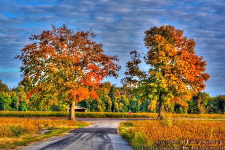
* photo above courtesy of Mike Hall.
A Promising Weekend
Every other week I look at the maps and think "this is it for Indian Summer; time to dig out the heavy stuff!"
Step away from the Doppler Paul.
Now we get super-sized autumns in Minnesota; the
last 10 Novembers warm enough to play golf in the metro area. Last
winter we saw 50s into Thanksgiving week.
Ask any farmer; they'll tell you the growing
season is longer than it was 40 years ago. Today's weather blog includes
a story, highlighting evidence that Midwestern corn planting comes 12.4
days earlier than it did in 1981.
Considering the sun will be as high in the sky
today as it was back on February 23 it's a bit reasurring to see 60s for
Sunday - the ECMWF is hinting at 70 next Tuesday!
Fleeting warmth is nice. So is rain.
Over 30 percent of Minnesota is now in extreme
drought - most of the MSP metro in a severe drought. A tenth of an inch
is possible today, a potential for heavier rain by the middle of next
week as Gulf moisture streams north, fueling an impressive storm.
We're sliding into a wetter pattern, but even a
naive optimist like me finds it doubtful we'll pick up 4 to 11 inches of
rain in the next month, enough moisture to kill the drought.
Then again.. we all know how quickly our weather can turn on a dime.
Climate Stories...
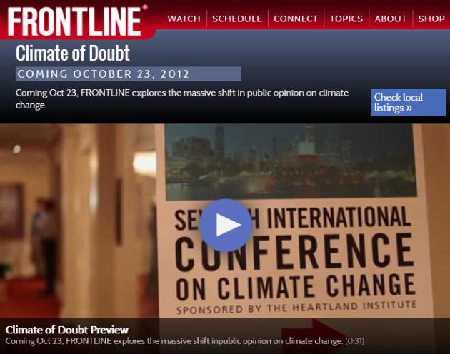
DVR Alert: "Climate of Doubt" on PBS Frontline Next Tuesday. Set
your DVR or VCR; Frontline (possibly the best documentaries on
television today) takes a look at orchestrated climate denial in the
USA. Here's an overview from
PBS: "
Four
years ago, climate change was a hot issue and politicians from both
sides seemed poised to act. Today public opinion on the climate issue
has cooled considerably. Politicians either ignore it or proclaim their
skepticism. What’s behind this massive reversal? On Oct 23, FRONTLINE
goes inside the organizations that fought the scientific establishment
to shift the direction of the climate debate."
Climate Change: The Debate's Great Unmentionable.
Let's just go crazy tapping all our fossil fuels, drill, mine and frack
our way to everlasting prosperity and millions of jobs! There's only one
small problem: if we tap all the available reserves of carbon,
worldwide, the trends we're seeing with melting Arctic ice, sea level
rise and extreme weather will only accelerate. It's already happening
faster than climate scientists predicted 20 years ago. Here's an excerpt
from
The New Yorker: "...
Obama
deserves credit for at least mentioning the need to control energy
demand—rather than just supply—something that Romney never even alluded
to. The President should also be commended for stressing the need to
develop alternative—which is to say carbon-free—energy sources, which he
called key to “the jobs of the future.” But aside from the potential
for job creation, the President could never quite bring himself to
discuss why it might not be a good idea to burn every gallon—or cubic
foot—of fossil fuels we could conceivably bring to the earth’s surface.
In the midst of what will almost certainly be the warmest year on record, climate change has become to the Obama Administration the Great Unmentionable, or, as the blogger Joe Romm has put it, The-Threat-That-Must-Not-Be Named...." Photo above: ABC News.
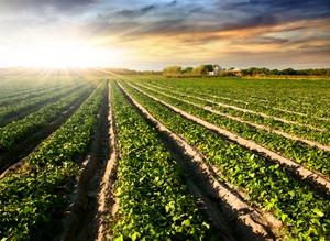
Climate Change And It's Effect On Agriculture. Here's a clip from the Marshall Democrat-News: "...
Earlier
planting dates are one example of change. According to an Iowa State
University Study from 1981 to 2005, The Midwest has seen its average
corn planting date advance by 0.40 days per year and the average
soybean planting date advance by 0.49 days per year. This is a result
of changes in the climate, newer hybrids and varieties and new methods
to manage early season insects and diseases. Further improvements in
agronomic traits and management options will occur. This will be the
result of an increased understanding of a plants biology and the use of
genomic sequencing and bioinformatics to understand plant biology..."
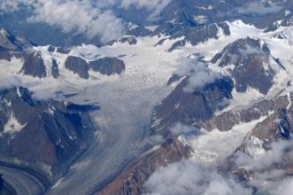
Slightly Increased 2012 Antarctic Sea Ice Levels No Match For Arctic Declines. The story from
The Yale Forum on Climate Change and The Media; here's an excerpt: "
Arctic
sea ice extent this past September reached the lowest point recorded
since satellites first started measuring sea ice in 1978. Arctic sea
ice blew past 2007′s record low, ending at 3.37 million square
kilometers, roughly half the size of the summer minimum ice cap during
the period from 1978 to 2000. At the same time, sea ice around
Antarctica has been approaching a record high. The Antarctic situation
has led some to dismiss the dramatic events in the Arctic as a simple
fluke, pointing to the growth of sea ice around Antarctica as a
counterpoint. What’s missing from that comparison is that the modest
growth of sea ice around Antarctica in no way compares to the dramatic
2012 declines seen in the Arctic nor, even more importantly, over the
past decade..."
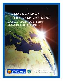
Americans' Global Warming Beliefs & Attitudes (Sept. 2012). Here are a few highlights of a recent
Yale Project on Climate Change report:
- Americans’ belief in the reality of global warming has
increased by 13 percentage points over the past two and a half years,
from 57 percent in January 2010 to 70 percent in September 2012. At the
same time, the number of Americans who say global warming is not
happening has declined nearly by half, from 20 percent in January 2010
to only 12 percent today.
- For the first time since 2008, more than half of
Americans (54%) believe global warming is caused mostly by human
activities, an increase of 8 points since March 2012. Americans who say
it is caused mostly by natural changes in the environment have
declined to 30 percent (from 37% in March).
Top 5 Threats To National Security In The Coming Decade. Here's an excerpt from
National Defense Magazine: ..."
Climate Change:
The national security ramifications of climate change are severe,
according to Defense Secretary Leon Panetta. While the topic of climate
change has been hugely politicized, Panetta casts the issue as a
serious security crisis. “In the 21st century, we recognize that
climate change can impact national security — ranging from rising sea
levels, to severe droughts, to the melting of the polar caps, to more
frequent and devastating natural disasters that raise demand for
humanitarian assistance and disaster relief,” Panetta said. The
administration projects that the change wrought by a warming planet
will lead to new conflicts over refugees and resources and catastrophic
natural disasters, all of which would require increased U.S. military
support and resources. The scientific community, in this area, cannot
agree on what it will take to reverse this trend. There is agreement,
though, that there is no silver bullet..."
Climate Change = War? Here's the introduction to a troubling story at
The Diplomat: "
For
all the heat generated by discussions of global warming in recent
months, it is an often overlooked fact that climate change has the
potential to create border disputes that in some cases could even
provoke clashes between states. Throw into the mix three nuclear-armed
nations with a history of disagreements, and the stakes of any conflict
rise incalculably. Yet such a scenario is becoming increasingly likely
as glaciers around the world melt, blurring international boundaries.
The chastened United Nation’s Intergovernmental Panel on Climate
Change, for example, still doesn’t dispute that glaciers are melting;
the only question is how fast..."


No comments:
Post a Comment