40s for highs into next week; shot at 50+ readings by Thursday.
No rain looking out into next weekend.
Dry Halloween for Minnesota, Trick or Treat temperatures near 40 F. in the metro area.
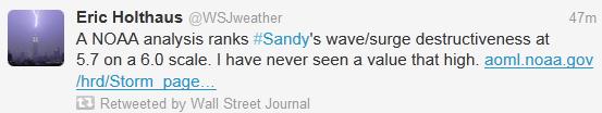
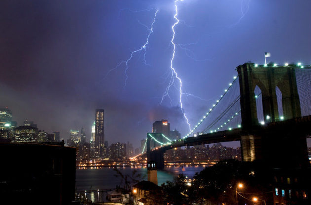
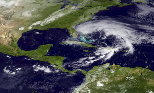
1 in 100 year Storm for New York City? The latest on Sandy below.
An Historic Storm
Prediction: you'll be hearing about the
implications of "Sandy" for many weeks to come. This sprawling, historic
hybrid mash-up of hurricane and fierce Nor'easter may even impact the
2012 Election.
Just a hunch.
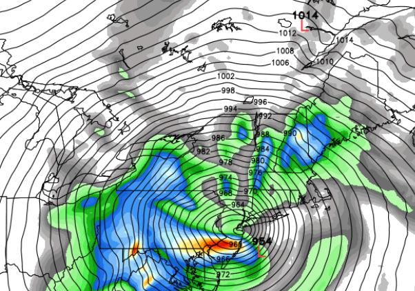
Most of the (60+) weather models we study show
Sandy pinwheeling just south of Long Island & New York City;
sustained 60-90 mph winds funneling water into the "New York Bight",
where New Jersey meets the Hudson River Valley. A full moon complicates
matters Monday afternoon, the worst day.
NOAA "Slosh" model simulations show an 8-9 foot
storm surge pushing across Long Island Sound into parts of Brooklyn and Queens. Runways at La Guardia Airport may be under 2 feet of water
Monday.
In a tornado you want to be below ground, in a basement - but hurricanes call for "vertical evacuations"; 3rd or 4th floor of a well-constructed building. Inland flooding and week-long power outages may impact an almost unprecedented swath of the northeast, from DC to Philly, New York & Boston.

 Why No Hurricane Watches or Warnings? Because Sandy
is transitioning from a warm-core (ocean-powered) hurricane into an
extra-tropical low pressure system, a classic Nor'easter, fed by
powerful temperature extremes and swirling jet stream winds aloft to
amplify and focus the storm's fury. More details on the transition and
terminology from NHC, via Facebook: "...thus,
once Sandy loses its tropical cyclone status it will be know as
"Post-tropical Cyclone Sandy" in NWS products. Some aspects of this
transition are already occurring, and NWS forecasts of storm impacts are
based on this expected evolution. Regardless of when this transition
occurs, Sandy is expected to bring significant wind, surge, rainfall and
inland flooding hazards over an extremely large area, and snowfall to
more limited areas. Because Sandy is expected to make this transition
before reaching the coast, the NWS has been using non-tropical wind
watches and warnings, issued by local NWS Weather Forecast Offices
(WFO's), to communicate the wind threat posed by Sandy in the
Mid-Atlantic States and New England (this is why NHC's tropical storm
warnings extend only into North Carolina). The NWS plans to continue
using non-tropical watches and warnings issued by local offices in the
Mid-Atlantic States and northward throughout this event. By using
non-tropical warnings in these areas from the start, we avoid or
minimize the significant confusion that could occur if the warning suite
changed from tropical to non-tropical in the middle of the event."
Why No Hurricane Watches or Warnings? Because Sandy
is transitioning from a warm-core (ocean-powered) hurricane into an
extra-tropical low pressure system, a classic Nor'easter, fed by
powerful temperature extremes and swirling jet stream winds aloft to
amplify and focus the storm's fury. More details on the transition and
terminology from NHC, via Facebook: "...thus,
once Sandy loses its tropical cyclone status it will be know as
"Post-tropical Cyclone Sandy" in NWS products. Some aspects of this
transition are already occurring, and NWS forecasts of storm impacts are
based on this expected evolution. Regardless of when this transition
occurs, Sandy is expected to bring significant wind, surge, rainfall and
inland flooding hazards over an extremely large area, and snowfall to
more limited areas. Because Sandy is expected to make this transition
before reaching the coast, the NWS has been using non-tropical wind
watches and warnings, issued by local NWS Weather Forecast Offices
(WFO's), to communicate the wind threat posed by Sandy in the
Mid-Atlantic States and New England (this is why NHC's tropical storm
warnings extend only into North Carolina). The NWS plans to continue
using non-tropical watches and warnings issued by local offices in the
Mid-Atlantic States and northward throughout this event. By using
non-tropical warnings in these areas from the start, we avoid or
minimize the significant confusion that could occur if the warning suite
changed from tropical to non-tropical in the middle of the event."
 Perspective. If a storm surge forecast of 4-9 feet
verifies in the New York City area it would be the worst flooding since
Gloria in 1985, possibly since ex-Tropical Storm Agnes merged with an
extra-tropical low pressure system to produce massive flooding in late
June, 1972. Source: nyc.gov.
Perspective. If a storm surge forecast of 4-9 feet
verifies in the New York City area it would be the worst flooding since
Gloria in 1985, possibly since ex-Tropical Storm Agnes merged with an
extra-tropical low pressure system to produce massive flooding in late
June, 1972. Source: nyc.gov.
 National Weather Service: "A Storm Like No Other". Details (and video) from The Associated Press: "The
National Weather Service says Hurricane Sandy is an extremely unique
storm that will hit the U.S. with strong winds and rain, potentially
causing massive damage."
National Weather Service: "A Storm Like No Other". Details (and video) from The Associated Press: "The
National Weather Service says Hurricane Sandy is an extremely unique
storm that will hit the U.S. with strong winds and rain, potentially
causing massive damage."
 Frankenstorm 2012: Sandy "Hybrid" To Hit Northeast.
We're seeing a higher amplitude weather pattern in recent years, weather
systems deeper, moving slower. Could record Arctic ice melt this summer
be having an impact, helping to generate fewer (but stronger) storms
like Sandy's spawn? Details from Huffington Post; here's an excerpt: "Hurricane Sandy
has already slammed Cuba, bringing heavy rain and winds around 110
miles per hour on Thursday, as it moved north. By Friday morning, the
death toll had already risen across the Caribbean. Climate Central
reported that the jet stream winds boxing in Sandy and creating a "Frankenstorm" are part of "blocking patterns [which] have appeared with greater frequency and intensity in recent years."
Some scientists have suggested the patterns could be linked to 2012's
record Arctic sea ice loss, which exposes more open water to absorb the
sun's energy. Representative Ed Markey (D-MA) released a report
Thursday, saying, "If climate change continues unchecked, Hurricane Sandy won’t be our October surprise, it could be the new normal for New England...."
Frankenstorm 2012: Sandy "Hybrid" To Hit Northeast.
We're seeing a higher amplitude weather pattern in recent years, weather
systems deeper, moving slower. Could record Arctic ice melt this summer
be having an impact, helping to generate fewer (but stronger) storms
like Sandy's spawn? Details from Huffington Post; here's an excerpt: "Hurricane Sandy
has already slammed Cuba, bringing heavy rain and winds around 110
miles per hour on Thursday, as it moved north. By Friday morning, the
death toll had already risen across the Caribbean. Climate Central
reported that the jet stream winds boxing in Sandy and creating a "Frankenstorm" are part of "blocking patterns [which] have appeared with greater frequency and intensity in recent years."
Some scientists have suggested the patterns could be linked to 2012's
record Arctic sea ice loss, which exposes more open water to absorb the
sun's energy. Representative Ed Markey (D-MA) released a report
Thursday, saying, "If climate change continues unchecked, Hurricane Sandy won’t be our October surprise, it could be the new normal for New England...."
 Hurricane Preparation. Details from FEMA's ready.gov web site:

 Alerts Broadcaster Update: Hurricane Sandy
is still on track to become a record storm for much of the Mid-Atlantic
and Northeast; as many as 50-75 million Americans may be impacted by
high winds, coastal flooding and extensive inland flooding by Tuesday. A
few headlines:
Alerts Broadcaster Update: Hurricane Sandy
is still on track to become a record storm for much of the Mid-Atlantic
and Northeast; as many as 50-75 million Americans may be impacted by
high winds, coastal flooding and extensive inland flooding by Tuesday. A
few headlines:
 Minimal Hurricane – Maximum Punch. Don’t be fooled by Sandy’s
Category 1 ranking. A powerful contrast in pressure between this
deepening storm, and a blocking ridge of high pressure to the north,
will create a vast area of 50-90 mph winds late Sunday into Tuesday
morning, as much as 250 miles wide as the storm “hooks” westward,
probably passing just south of Long Island and New York City. Map: Ham Weather.
Minimal Hurricane – Maximum Punch. Don’t be fooled by Sandy’s
Category 1 ranking. A powerful contrast in pressure between this
deepening storm, and a blocking ridge of high pressure to the north,
will create a vast area of 50-90 mph winds late Sunday into Tuesday
morning, as much as 250 miles wide as the storm “hooks” westward,
probably passing just south of Long Island and New York City. Map: Ham Weather.
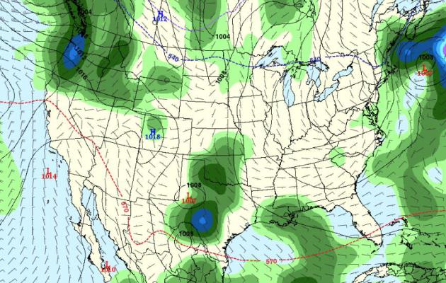
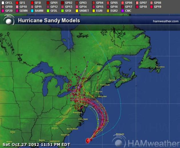 Latest Model Ensemble. A majority of weather models bring
Sandy’s path south of New York City and Long Island. Keep in mind that
the most extreme storm surge will take place north of wherever Sandy
comes ashore. We are placing special emphasis (as is NHC) on the GFS and
ECMWF (European) solutions. Map: Ham Weather.
Latest Model Ensemble. A majority of weather models bring
Sandy’s path south of New York City and Long Island. Keep in mind that
the most extreme storm surge will take place north of wherever Sandy
comes ashore. We are placing special emphasis (as is NHC) on the GFS and
ECMWF (European) solutions. Map: Ham Weather.
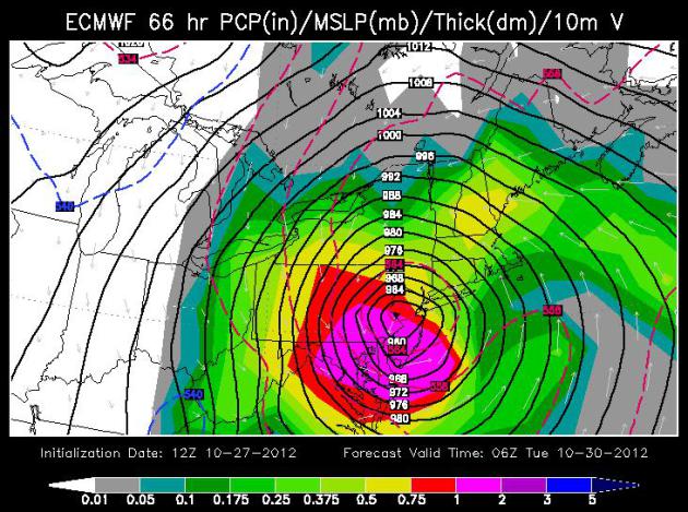 European (ECMWF) Model. The ECMWF was the first model to turn
Sandy inland – back on Monday we predicted that Sandy would, in fact,
impact the northeastern USA. So I’m putting a little additional weight
on this model, which shows landfall just north of Atlantic City Monday
night. Map above valid 1 am Tuesday morning. The purple-shaded area
designates the most extreme rains, with as much as 1-2” of rain falling
every 3 hours from the Delaware Valley to Washington D.C. The greatest
impact of inland flooding comes Monday afternoon into Tuesday morning. Map: WSI Corporation.
European (ECMWF) Model. The ECMWF was the first model to turn
Sandy inland – back on Monday we predicted that Sandy would, in fact,
impact the northeastern USA. So I’m putting a little additional weight
on this model, which shows landfall just north of Atlantic City Monday
night. Map above valid 1 am Tuesday morning. The purple-shaded area
designates the most extreme rains, with as much as 1-2” of rain falling
every 3 hours from the Delaware Valley to Washington D.C. The greatest
impact of inland flooding comes Monday afternoon into Tuesday morning. Map: WSI Corporation.
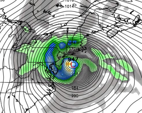 GFS Model. Underscoring and validating the ECMWF simulation,
the latest GFS run also shows a landfall near Atlantic City Monday
evening at 7 pm (00z GFS run). This could be close to a worst-case
scenario for Manhattan: sustained east/southeast winds, coupled with
extremely low pressure, carving out a dome of water, a “storm surge”, as
much as 5-10 feet above normal high tide. A full moon Monday increases
the risk of historic flooding, possibly comparable to the June 22, 1972
flood, which was sparked by Tropical Storm Agnes fusing with another
storm, resulting in 122 deaths and $6 billion in damage (nyc.gov). Map: Weather Bell.
GFS Model. Underscoring and validating the ECMWF simulation,
the latest GFS run also shows a landfall near Atlantic City Monday
evening at 7 pm (00z GFS run). This could be close to a worst-case
scenario for Manhattan: sustained east/southeast winds, coupled with
extremely low pressure, carving out a dome of water, a “storm surge”, as
much as 5-10 feet above normal high tide. A full moon Monday increases
the risk of historic flooding, possibly comparable to the June 22, 1972
flood, which was sparked by Tropical Storm Agnes fusing with another
storm, resulting in 122 deaths and $6 billion in damage (nyc.gov). Map: Weather Bell.
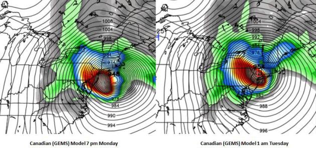 Canadian Model Solution. The GEMS model from Environment
Canada shows a vaguely similar left-hand turn for Sandy late Monday into
Tuesday morning, with the core of the storm passing almost directly
over New York City by 1 am Tuesday morning. I want to stress that
Boston, Cape Cod, Martha’s Vineyard, Nantucket, Providence and coastal
Long Island will also experience potentially historic flooding, due to
the combination of a powerful differential in air pressure, slow
movement and a full moon late Monday. Map: Weather Bell.
Canadian Model Solution. The GEMS model from Environment
Canada shows a vaguely similar left-hand turn for Sandy late Monday into
Tuesday morning, with the core of the storm passing almost directly
over New York City by 1 am Tuesday morning. I want to stress that
Boston, Cape Cod, Martha’s Vineyard, Nantucket, Providence and coastal
Long Island will also experience potentially historic flooding, due to
the combination of a powerful differential in air pressure, slow
movement and a full moon late Monday. Map: Weather Bell.
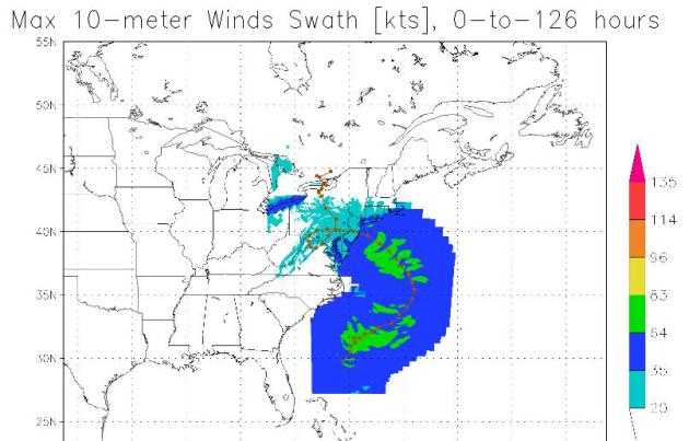
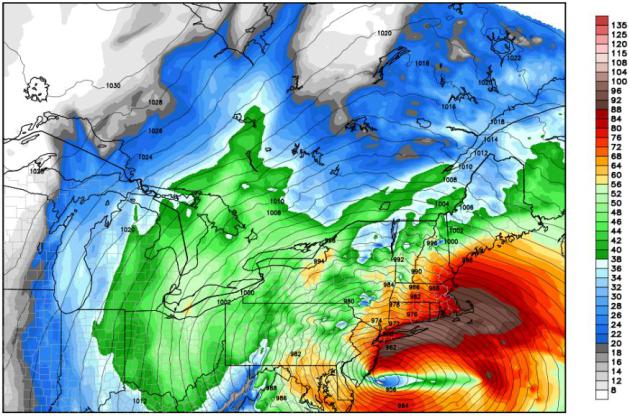 Sprawling Wind Field. This is a map showing the huge swath of
hurricane-force winds at 1 pm Monday, stretching from near Boston and
Cape Cod to coastal Rhode Island, Connecticut and Long Island. These are
wind predictions for 900 mb, about 1,500 feet above the ground, but I
expect surface winds to be in the 70-95 mph range from midday Monday
into early Tuesday morning. Data: NAM-WRF.
Sprawling Wind Field. This is a map showing the huge swath of
hurricane-force winds at 1 pm Monday, stretching from near Boston and
Cape Cod to coastal Rhode Island, Connecticut and Long Island. These are
wind predictions for 900 mb, about 1,500 feet above the ground, but I
expect surface winds to be in the 70-95 mph range from midday Monday
into early Tuesday morning. Data: NAM-WRF.
 Dangerous Storm Surge. NOAA’s “Slosh” models are showing a
storm surge as high as 6-10 feet above mean sea level Monday evening at 7
pm over the westernmost tip of Long Island Sound – pushing water into
Queens and Brookyn. Both JFK and LGA may see runways inundated by
rapidly rising water as Sandy tracks just south of Long Island. Map above: NOAA.
Dangerous Storm Surge. NOAA’s “Slosh” models are showing a
storm surge as high as 6-10 feet above mean sea level Monday evening at 7
pm over the westernmost tip of Long Island Sound – pushing water into
Queens and Brookyn. Both JFK and LGA may see runways inundated by
rapidly rising water as Sandy tracks just south of Long Island. Map above: NOAA.

 Experts: Team Obama Should Root For Hurricane Sandy To Interrupt Election. And what a mess that would be; U.S. News and World Report has an intriguing story - here's an excerpt: "...Pastor
says a natural disaster that impacts the election would "stretch the
fabric of American Democracy to the point of being torn" because, in
many cases, local disputes over voting "would be addressed in an area
where one party is largely dominant and the rules are extremely weak."
So far, American elections have been fairly natural disaster-free.
Hudak says there have been some "small scale issues" with blizzards in
the upper plains and Rocky Mountain states in previous elections. With
any luck, that streak will continue in 2012. But even if Sandy isn't
catastrophic, inclement weather throughout the country could have a more
predictable impact on the election..."
Experts: Team Obama Should Root For Hurricane Sandy To Interrupt Election. And what a mess that would be; U.S. News and World Report has an intriguing story - here's an excerpt: "...Pastor
says a natural disaster that impacts the election would "stretch the
fabric of American Democracy to the point of being torn" because, in
many cases, local disputes over voting "would be addressed in an area
where one party is largely dominant and the rules are extremely weak."
So far, American elections have been fairly natural disaster-free.
Hudak says there have been some "small scale issues" with blizzards in
the upper plains and Rocky Mountain states in previous elections. With
any luck, that streak will continue in 2012. But even if Sandy isn't
catastrophic, inclement weather throughout the country could have a more
predictable impact on the election..."
 Election Day Weather. Here is the updated GFS (very
extended) Outlook for Tuesday evening, November 6. Overall the forecast
looks drier than it did yesterday, the only rain over northern New
England, Louisiana, Texas and the Pacific Northwest, a few light showers
from Grand Forks to Duluth and the Twin Cities.
Election Day Weather. Here is the updated GFS (very
extended) Outlook for Tuesday evening, November 6. Overall the forecast
looks drier than it did yesterday, the only rain over northern New
England, Louisiana, Texas and the Pacific Northwest, a few light showers
from Grand Forks to Duluth and the Twin Cities.
 "Ask Paul". Weather-related Q&A:
TJ - thanks for a great question. The big difference this time
around: there are no storms nearby, capable of stalling and squeezing
out heavy, sustained rain (or snow). The 1991 "Perfect Storm" stalled
over New England, which caused a Minnesota storm to stall over Lake
Superior, prolonging our snow for 2-3 days, whipping up nearly 30" of
snow (as many of us remember vividly). This time around high pressure
will stall overhead, keeping us partly sunny, cool and quiet into much
of next week.
 "No Weather". The same ECMWF (European) model we're using to try to
track Sandy shows a benign weather pattern for Minnsota and the Upper
Midwest, a weak upper level ridge stalled overhead, a series of very
weak clippers producing some patchy clouds today and Monday, again
Halloween, but highs in the 40s, maybe topping 50 by Thursday. The next
chance of a cold rain: a week from Monday.
"No Weather". The same ECMWF (European) model we're using to try to
track Sandy shows a benign weather pattern for Minnsota and the Upper
Midwest, a weak upper level ridge stalled overhead, a series of very
weak clippers producing some patchy clouds today and Monday, again
Halloween, but highs in the 40s, maybe topping 50 by Thursday. The next
chance of a cold rain: a week from Monday.
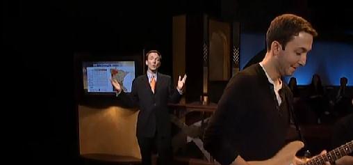 Slow Jam Weather. Yep, we have a good time on TPT Almanac.
Last Friday I did the weather, with my son (Walt, of "The Lost Wheels")
playing lead guitar. A weather-music mash-up. I doubt it'll ever catch
on, but we did have some fun experimenting with a new (and
forgettable) weather format! Thanks to David Gillette from TPT Almanac
for taking a chance. No, NBC's Jimmy Fallon should not feel the least
bit threatened by my lame attempt...
Slow Jam Weather. Yep, we have a good time on TPT Almanac.
Last Friday I did the weather, with my son (Walt, of "The Lost Wheels")
playing lead guitar. A weather-music mash-up. I doubt it'll ever catch
on, but we did have some fun experimenting with a new (and
forgettable) weather format! Thanks to David Gillette from TPT Almanac
for taking a chance. No, NBC's Jimmy Fallon should not feel the least
bit threatened by my lame attempt...
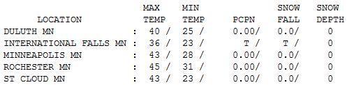
 Blue and Brisk. The sun was out part of the day, but
temperatures were more than 10 degrees cooler than average, statewide,
ranging from a high of 36 at International Falls to 40 Duluth, 43 St.
Cloud and Twin Cities and 45 at Rochester.
Blue and Brisk. The sun was out part of the day, but
temperatures were more than 10 degrees cooler than average, statewide,
ranging from a high of 36 at International Falls to 40 Duluth, 43 St.
Cloud and Twin Cities and 45 at Rochester.
Paul's Conservation Minnesota Outlook for the Twin Cities and all of Minnesota (and western Wisconsin too):
Climate Stories...
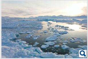 Arctic Thaw Will Release 850 Billion Tons Of Carbon, Says Latest Study. The Times of India has the story; here's an excerpt: "Global warming
just spun more out of control than thought. As much as 44 billion tons
of nitrogen and 850 billion tons of carbon stored in the frozen wastes
of Arctic could be released into the environment as the region begins
to thaw over the next century, a new study led by the US Geological
Survey said. The thawing process has already started with sea-ice
levels at their lowest this summer. What is staggering is the the new
numbers put out by the USGS. If these are correct, it would mean that
carbon quantity in the atmosphere
will roughly double. It will greatly enhance the rate at which warming
is already taking place and could cause widespread destruction of life
and habitat..."
Arctic Thaw Will Release 850 Billion Tons Of Carbon, Says Latest Study. The Times of India has the story; here's an excerpt: "Global warming
just spun more out of control than thought. As much as 44 billion tons
of nitrogen and 850 billion tons of carbon stored in the frozen wastes
of Arctic could be released into the environment as the region begins
to thaw over the next century, a new study led by the US Geological
Survey said. The thawing process has already started with sea-ice
levels at their lowest this summer. What is staggering is the the new
numbers put out by the USGS. If these are correct, it would mean that
carbon quantity in the atmosphere
will roughly double. It will greatly enhance the rate at which warming
is already taking place and could cause widespread destruction of life
and habitat..."
Photo credit above: "This is the first time an estimate of the nitrogen trapped in the Arctic permafrost has been released. Scientists had till now been using computer model based climate predictions."
 It May Be Too Late To Start Global Warming. I'm a
naive optimist, but I agree. We have to move from ill-fated attempts at
(global) regulation, which are probably doomed to failure... to
adaptation, and quickly. ABC News has the story - and video clip with Diane Sawyer; here's an excerpt: "Here's
a dark secret about the earth's changing climate that many scientists
believe, but few seem eager to discuss: It's too late to stop global
warming. Greenhouse gasses pumped into the planet's atmosphere will
continue to grow even if the industrialized nations cut their emissions
down to the bone. Furthermore, the severe measures that would have to
be taken to make those reductions stand about the same chance as that
proverbial snowball in hell. Two scientists who believe we are on the
wrong track argue in the current issue of the journal Nature Climate
Change that global warming is inevitable and it's time to switch our
focus from trying to stop it to figuring out how we are going to deal
with its consequences.."
It May Be Too Late To Start Global Warming. I'm a
naive optimist, but I agree. We have to move from ill-fated attempts at
(global) regulation, which are probably doomed to failure... to
adaptation, and quickly. ABC News has the story - and video clip with Diane Sawyer; here's an excerpt: "Here's
a dark secret about the earth's changing climate that many scientists
believe, but few seem eager to discuss: It's too late to stop global
warming. Greenhouse gasses pumped into the planet's atmosphere will
continue to grow even if the industrialized nations cut their emissions
down to the bone. Furthermore, the severe measures that would have to
be taken to make those reductions stand about the same chance as that
proverbial snowball in hell. Two scientists who believe we are on the
wrong track argue in the current issue of the journal Nature Climate
Change that global warming is inevitable and it's time to switch our
focus from trying to stop it to figuring out how we are going to deal
with its consequences.."
 MTV Shatters Climate Science With Serious Question To President Obama, And Obama Gives A Serious Response. Here's an excerpt from an article at getenergysmart.com: "...And, from President Barack Obama, Calloway received a serious answer from the get-go:
 Could Climate Change Be The Epitome Of Partisanship? Pacific Standard has a thought-provoking story; here's a snippet: "It’s the issue that dare not speak its name – climate change. As the New York Times, NPR, the Associated Press and a host of pundits, including our Tom Jacobs,
have noticed, talk of global warming has been banished from the
hustings in this year’s U.S. presidential campaign. While both Barack
Obama and Mitt Romney embrace talk about energy – whether from fossil
fuels or renewable sources – with various amounts of gusto, the focus is
always economic, not environmental. Despite his muted voice this year,
in years past Obama has been an ardent believer in anthropogenic
climate change. Romney has said he accepts the that the planet is
warming, and that people have played some part in the increase, but it’s never been a centerpiece of his platform. The environment is not among the 27 issues on his campaign website, although energy is, and his position has seen a rightward shift, as CBS News described it..."
Could Climate Change Be The Epitome Of Partisanship? Pacific Standard has a thought-provoking story; here's a snippet: "It’s the issue that dare not speak its name – climate change. As the New York Times, NPR, the Associated Press and a host of pundits, including our Tom Jacobs,
have noticed, talk of global warming has been banished from the
hustings in this year’s U.S. presidential campaign. While both Barack
Obama and Mitt Romney embrace talk about energy – whether from fossil
fuels or renewable sources – with various amounts of gusto, the focus is
always economic, not environmental. Despite his muted voice this year,
in years past Obama has been an ardent believer in anthropogenic
climate change. Romney has said he accepts the that the planet is
warming, and that people have played some part in the increase, but it’s never been a centerpiece of his platform. The environment is not among the 27 issues on his campaign website, although energy is, and his position has seen a rightward shift, as CBS News described it..."
In a tornado you want to be below ground, in a basement - but hurricanes call for "vertical evacuations"; 3rd or 4th floor of a well-constructed building. Inland flooding and week-long power outages may impact an almost unprecedented swath of the northeast, from DC to Philly, New York & Boston.
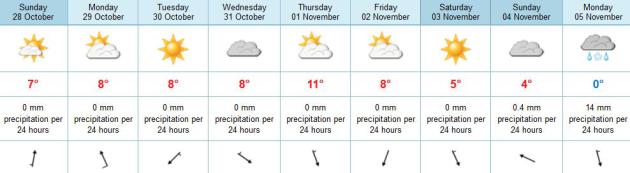
A quiet week is shaping up here; dry for
Halloween - 50 F. will feel surprisingly good by Thursday. A cold rain
next Monday may end as a few wet snowflakes; skies clear for Election
Day 2012.
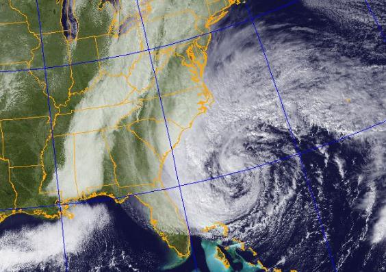
Still On Track.
The 00z NAM shows extra-tropical Nor'easter passing very close to New
York City by 10 pm Monday night, capable of a very damaging storm surge
over Long Island and even pushing into New York Harbor, with
hurricane-force winds extending inland as far as Hartford, Albany,
Wilkes-Barre and Philadelphia Monday night.
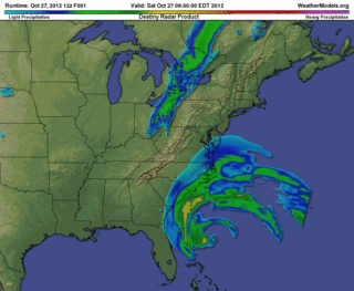
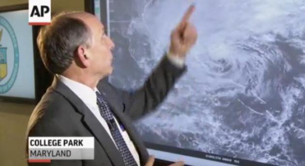
Sandy: second largest tropical
storm in the Atlantic since 1988; tropical storm-force winds extending
450 miles from the center of the storm (northeast quadrant). Source: Weather Underground. Future Radar (WRF-NMM) model courtesy of Ham Weather.
60 million Americans may be impacted by Sandy - with implications for the 2012 elections, according to the BBC.
Unprecedented? From the Saturday night Baltimore, MD/Washington D.C. NWS discussion: "I
cannot recall ever seeing model forecasts of such an expansive areal
wind field with values so high for so long a time. We are breaking new
ground here."
Monday Morning Storm Surge. NOAA models are hinting at a 5 foot storm surge Monday morning along the Jersey shore - map above valid 7 am Monday.
What Keeps Us Up At Night? The
same NOAA "Slosh" model is hinting at a 6-10 foot storm surge for Long
Island Sound by 7 pm Monday; the combination of sustained 60-80 mph.
winds and low pressure (and a full moon) carving out a "dome" of water,
pushed along by Sandy - water literally piling up north of Long Island -
pushing toward LGA, JFK and lowland areas of Brooklyn and Queens. Not
sure why they're not moving people.
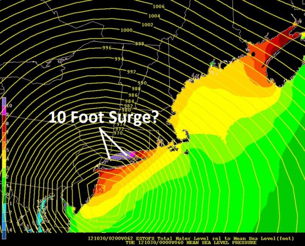
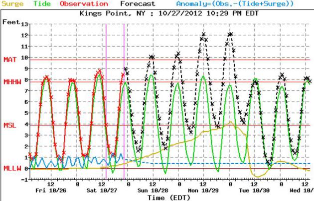
8-12 Foot Storm Surge? Here is
the NOAA forecast for Kings Point, New York, east of La Guardia Airport,
showing a steady rise in water levels, peaking Monday night - the
combination of storm surge, high tide (and full moon) creating a
possible 10+ rise in water levels in Long Island Sound.
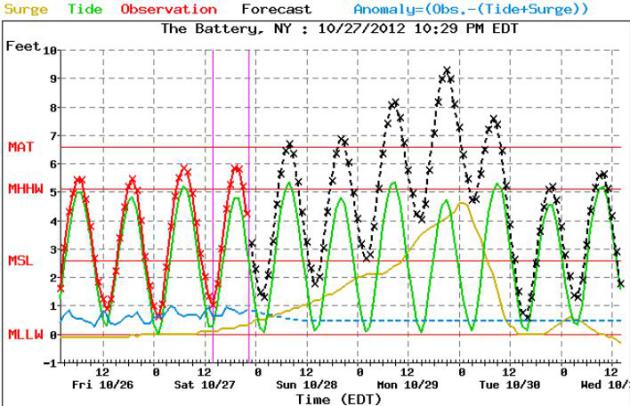
Major Flooding For Lower Manhattan? Here is the NOAA forecast
for water levels at The Battery - showing some potentially jaw-dropping
rises in water levels. A storm surge of 4-5 feet, superimposed high
tide (and full moon) may have some very unpleasant consequences for
low-lying areas of Manhattan, Brooklyn, Queens and Staten Island.
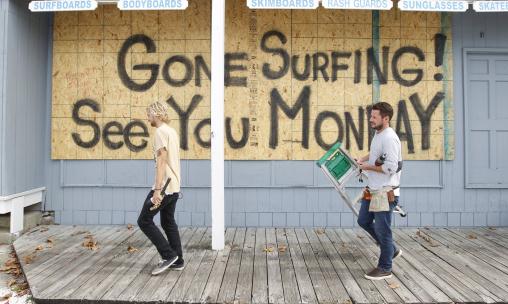
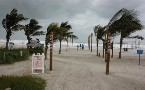
Forecast: Big Surf. Photo details: "Store
workers Fletcher Birch, right, and Jay Kleman finish boarding up the
windows on a surf store in Ocean City, Md. on Saturday, Oct. 27, 2012
as Hurricane Sandy approaches the Atlantic coast." (AP Photo/Jose Luis Magana)
NOAA HFIP - Experimental Real-Time High Resolution Forecasts. Forecast track courtesy of NOAA AOML.
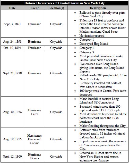
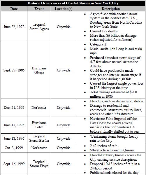
New York City's Most Destructive Storms Since 1821. File photo credit here.
- To begin preparing, you should build an emergency kit and make a family communications plan.
- Know your surroundings.
- Learn the elevation level of your property and whether the land is flood-prone. This will help you know how your property will be affected when storm surge or tidal flooding are forecasted.
- Identify levees and dams in your area and determine whether they pose a hazard to you.
- Learn community hurricane evacuation routes and how to find higher ground. Determine where you would go and how you would get there if you needed to evacuate.
- Make plans to secure your property:
- Cover all of your home’s windows. Permanent storm shutters offer the best protection for windows. A second option is to board up windows with 5/8” marine plywood, cut to fit and ready to install. Tape does not prevent windows from breaking.
- Install straps or additional clips to securely fasten your roof to the frame structure. This will reduce roof damage.
- Be sure trees and shrubs around your home are well trimmed so they are more wind resistant.
- Clear loose and clogged rain gutters and downspouts.
- Reinforce your garage doors; if wind enters a garage it can cause dangerous and expensive structural damage.
- Plan to bring in all outdoor furniture, decorations, garbage cans and anything else that is not tied down.
- Determine how and where to secure your boat.
- Install a generator for emergencies.
- If in a high-rise building, be prepared to take shelter on or below the 10th floor.
- Consider building a safe room.
Here is an edited version of what I sent our corporate Alerts Broadcaster clients Saturday PM:
* Conditions deteriorate during the day Sunday,
from south to north across the Mid-Atlantic region. Accelerate
preparations to secure facilities and safeguard staff early in the day
Sunday.
* The storm peaks Monday and Monday night;
conditions slowly improve by Tuesday afternoon as the center of Sandy
moves inland and slowly dissipates.
* New York City officials are discussing evacuation plans
and even closing the subways at the height of the storm (Monday).
“SLOSH” simulations are predicting as much as 6-9 feet of water pushing
across Long Island Sound into parts of Queens and Brooklyn. A storm
surge coming up New York Harbor may flood Lower Manhattan and Battery
Park. Areas within 5 feet of sea level are threatened. My hunch: La
Guardia Airport and JFK may see runway inundation Monday, with as much
as 1-3 feet of standing water on some runways.
* NBC in New York
reports that MTA officials are considering shutting down subways,
bridges and commuter rails by 7 pm Sunday. No final decision has been
made as of 10 pm eastern time, but I anticipate that this will, in fact,
happen. Don’t wait until the last minute.
* A 4-8 foot storm surge is possible over coastal
New Jersey and the southern coastline of Long Island. Communities that
have a history of severe flooding during hurricanes and severe
Nor’easters can expect widespread flooding from Sandy.
* Many coastal highways within 3-4 feet of sea
level will be closed by Sunday night. Again, if you plan to evacuate
away from the coast/sea level, the time to do it is now, or Sunday
morning at the latest.
Summary: Sandy is still on track to deliver a
punishing blow to much of the northeast, the slow speed, extreme
pressure gradient and full moon on Monday making this historic
Nor’easter equivalent to a Category 1-2 hurricane. It’s still impossible
to pin down where the most severe storm surge will take place – the
level of water hinges on the precise track Sandy takes as it passes
south of Long Island and New York City Monday.
Consider accelerating your preparations to
safeguard life and property. Remember the impact of inland flooding –
many towns will lose power for several days, perhaps longer. If you live
within 5-7 feet of sea level, in an arc from New Jersey to New York to
Long Island and southern New England, have a Plan B, well inland. The
best advice if you can’t reach higher ground in time: vertical
evacuations. Find shelter on the third or fourth floor of a well
constructed building (office complex or hotel), well away from outer
walls and windows to safeguard yourself from flying debris and broken
glass.
Sandy may be a hybrid hurricane – Nor’easter by the
time it pushes ashore Monday night; but there’s little doubt this will
be an historic storm.
Remembering Irene: Don't Underestimate Risk of Inland Flooding. NOAA HPC is predicting a wide swatch of 4-8" rains from Sandy, with some 10" amounts over the Delmarva Peninsula.
* Election In Sandy's Shadow. Politico.com reports on the implications of Hurricane Sandy complicating the 2012 Election; details here.
Hello Paul,
"From what I read, Hurricane Grace hit the NE US in Halloween 1991 and created the Perfect Storm. Of course, Minneapolis also got hit with the Halloween Blizzard of 1991 about the same time.
With Sandy bearing down on the NE Coast and with some predicting another Perfect Storm in that area, what is different in the Upper Midwest's atmospheric conditions that there isn't even a hint of snow here for this year, let alone a Blizzard? For those not meteorologically gifted, there would seem to be some parallel to 1991 conditiions and what's predicted for this year's Halloween's weather.
Please explain the difference in weather conditions between this year and 1991. Was there a connection between Grace and the Halloween Blizzard, and if so, why isn't that forecasted for this year? It's not like I miss 29" of snow, but would appreciate an explanation."
Thank you!
TJ Hanson
Paul's Conservation Minnesota Outlook for the Twin Cities and all of Minnesota (and western Wisconsin too):
TODAY: More clouds than sun. Winds: South 5-10. High: 45
SUNDAY NIGHT: Patchy clouds. Low: 29
MONDAY: Mix of clouds and sun, not bad. High: 47
TUESDAY: Lot's of sun - cool breeze. Low: 27. High: 44
WEDNESDAY: Zombie Alert. Dry Halloween with sun fading behind increasing clouds. Low: 29. High: 45
THURSDAY: Plenty of sun, still quiet. Low: 31. High: 50
FRIDAY: Patches of blue sky, dry sky. Low: 33. High: 49
SATURDAY: Weak clipper. Sunny, cooler. Low: 31. High: 46
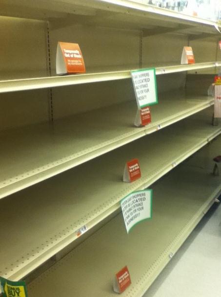
* photo of empty store shelves in Harrisburg, PA above courtesy of MD Guzy.
Climate Stories...
Photo credit above: "This is the first time an estimate of the nitrogen trapped in the Arctic permafrost has been released. Scientists had till now been using computer model based climate predictions."
The answer is number one, we’re not moving as fast as we need toAbsolutely true …
And there is a huge contrast in this campaign between myself and Governor RomneyAbsolutely true …
I am surprised it didn’t come up in one of the debates.Terrifyingly true … although President Obama and Vice President Biden literally had hours of opportunities to raise the issue since, after all, it is related to domestic and foreign policy, to budget issues and security, and to energy issues where we had President Obama and Mitt Romney arguing over who was the better friend to fossil fuels. (Hint … Romney did win this but the President made him work for the title.)"
No comments:
Post a Comment