60 F. high yesterday in the Twin Cities.
54 F. average high for October 24.
62 F. high on October 24, 2011.
.10" rain fell at KMSP
yesterday.
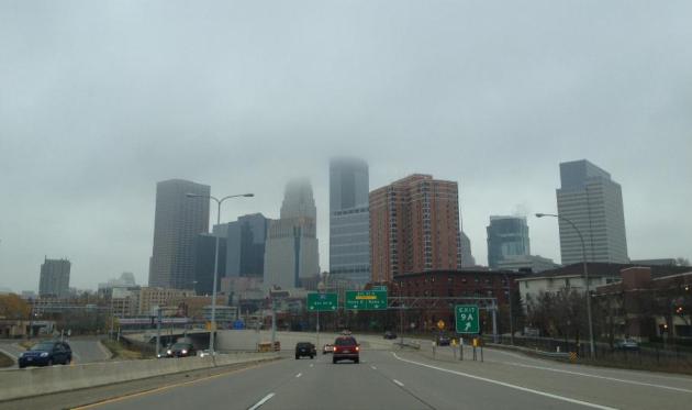
Rain mixes with wet snow by midday today.
Severe drought lingers over most of the Twin Cities, extreme drought southwestern MN.
 .85"
.85" rain predicted today, mixing with
wet snow possible by midday. Some slush is possible on lawns, roads stay wet. The evening rush hour should be (a little) easier than getting to work or school this morning.
 Touch of Wet Snow?
A cold rain will end as a little wet snow, a coating to an inch of
slush (on lawns and fields) possible by midday, mainly north/west of the
metro area. Roads will stay wet with temperatures staying above 32 F.
 Half-Decent Halloween?
Nothing to scary in the extended outlook, a couple of chilly days, a
dry weekend as temperatures slowly moderate. The ECMWF is hinting at
highs near 50 Tuesday and Halloween, a slight chance of a shower next
Wednesday. But no heavy, steady rain. We're in a drought, come to think
of it.
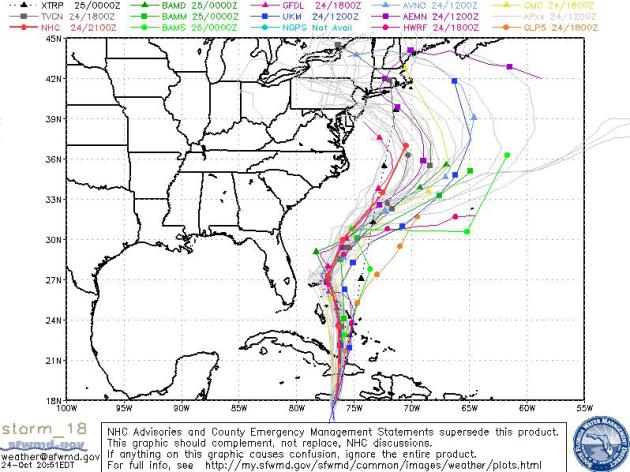
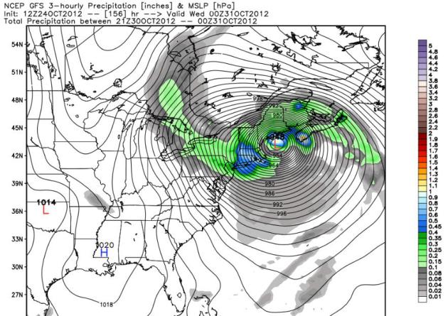
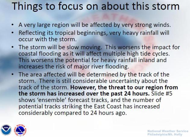
U.S. Landfall Looking More Likely. All but one model
now curves Sandy inland by the weekend and early next week, falling
into line with what the ECMWF was hinting at 3 days ago. But the range
of possible landfalls is unsettling, stretching from Norfolk to
Portland, Maine. By then "Sandy" will probably be extra-tropical, losing
some of its hurricane characteristics, but still capable of generating
hurricane force winds as a (turbo-charged) Nor'Easter, a potential
superstorm, what meteorologists call a "bomb".
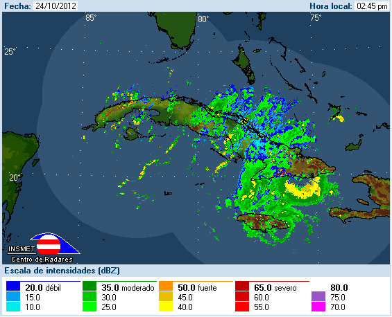
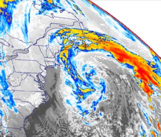
Cuba/Jamaica Radar Composite. Radar loop from 9:50 pm Wednesday night. For an updated loop click here, courtesy of
cewn.net.
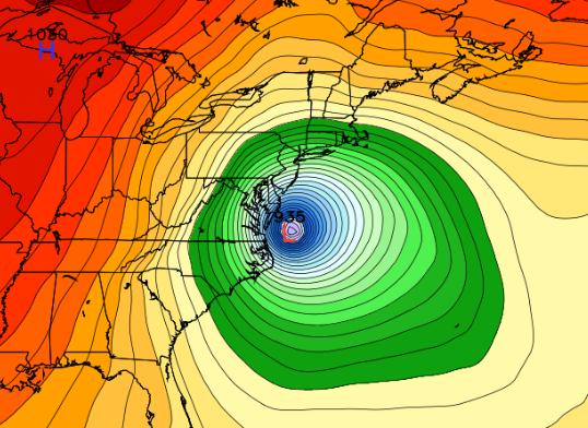
Atmospheric Bomb?
The well-coiffed pollsters on TV tell me it's a
close race. Research suggests that storms can keep (some) people away
from the polls. So can hurricane damage. My hunch: Hurricane Sandy may
have a significant impact on this year's election.
Meteorologists speak of "bombs", massive
superstorms that spin up along the leading edge of bitter outbreaks. The
same cold front sparking a cold rain and penetrating chill may act like
a giant atmospheric vacuum cleaner, sucking Hurricane Sandy into the
northeast early next week, anywhere from DC to Cape Cod. This reminds me
of "Grace" in 1991. Some of its energy fueled a hybrid Nor'easter, the
storm that became New England's "Perfect Storm". It stalled out, forcing
a storm to stall over Lake Superior. We were left with over 30 inches
of snow as a result; the infamous Halloween Superstorm.
History repeats itself - with unpleasant regularity.
A cold rain ends as a slushy coating near
Brainerd today; temperatures tumbling thru the 40s. Expect cool sun
Friday into much the weekend; 50 will feel amazingly good again by
Tuesday.
Wait, a hurricane for Washington D.C.?
Finally, something politicians can agree on.
Remembering "The Perfect Storm": Halloween, 1991.
The remains of Category 2 "Grace" helped to fuel a monster storm, the
Nor'easter that punished the Outer Banks and much of New England, the
inspiration behind Sebastian Junger's book, "The Perfect Storm".
NOAA NCDC has a good overview of the storm; here's an excerpt: "...
On
October 28, 1991, a extratropical cyclone developed along a cold front
which had moved off the Northeast coast of the U.S. By 1800 UTC, this
low was located a few hundred miles east of the coast of Nova Scotia.
With strong upper air support, the low rapidly deepened and became the
dominant weather feature in the Western Atlantic. Hurricane Grace,
which had formed on October 27 from a pre-existing subtropical storm
and was initially moving northwestward, made a hairpin turn to the east
in response to the strong, westerly deep-layer mean flow on the
southern flank of the developing extratropical low. Grace was a large
system and it was already generating large swells ranging in size from
about 15 feet offshore of North Carolina to about 10 feet near the
Florida coastline..."
The likelihood of Hurricane Sandy impacting the Mid-Atlantic region and New England has risen from 45% last night to
65% today.
This is based on overall model trends, with special emphasis on the
European (ECMWF) solution, which was the first weather simulation to
pull Sandy northwestward, toward the USA, and continues to do so.
Although confidence levels continue to rise that Hurricane Sandy will impact the northeast, in a Sunday – Tuesday time frame, the exact location of landfall is still highly speculative. Models are all over the map (literally).
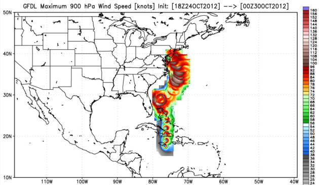
Hurricane Sandy Headlines
A Near-Miss for Florida. The NAM model shows the core of
Sandy’s strongest winds and waves remaining just east of Florida – but
it will be a close call.
1). Florida will experience a near-miss Friday into
Saturday morning, with a potential for hurricane-force wind gusts along
the Atlantic coast of the Sunshine State. I do expect considerable
beach erosion and coastal flooding, but the worst of Sandy will remain
100-300 miles offshore. Miami will dodge a bullet, but barely.
2). The Carolinas and Outer Banks may experience
near hurricane-force winds over the weekend. The Outer Banks will bear
the brunt of these 65-90 mph winds, with considerable flooding and a
possible storm surge 3-8 feet above normal high tide.
3). Landfall in the northeast is expected anytime
from Sunday evening thru Tuesday. The storm may mutate into a hybrid
hurricane-nor’easter, similar to “The Perfect Storm” in 1991, which was
fueled by the remains of Hurricane Grace. Even if the storm loses warm
core hurricane characteristics it may still produce wind gusts
approaching or exceeding 100 mph as it comes ashore, and within 100
miles of the coast.
4). The worst conditions (coastal flooding, beach erosion, roof and structural damage, etc) will take place to the north/east of the storm track and where Sandy eventually comes ashore.
5). Hurricane or Nor'easter, or both? Sandy may
lose its warm-core hurricane-like characteristics by the time it
approaches the U.S. coast, possibly a hybrid hurricane/nor'easter. But a
powerful contrast in pressure will continue to create hurricane-force
winds. The size of the storm is also a consideration - Sandy is a huge
system, capable of a 200-300 mile wide zone of hurricane-force winds.
And in the end it becomes a matter of semantics: was it a hurricane or a
violent nor-easter? If it takes your roof off, it probably doesn't
matter what you call it.
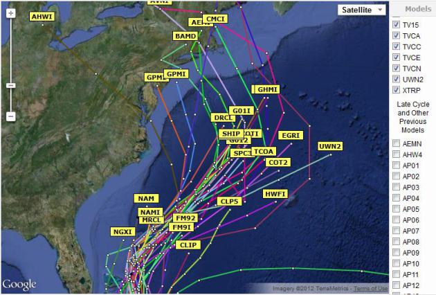
A Major Shift In The Models. Early this morning 2/3rds of the
weather models were turning “Sandy” to the northwest early next week.
Now a vast majority of the models (more than 90%) are turning the storm
toward the northeastern USA Sunday and Monday.
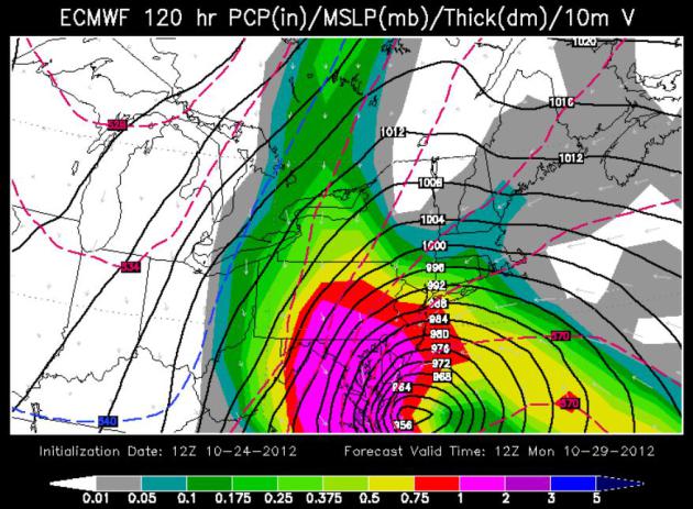
European (ECMWF) Solution. What I consider to be the most
reliable long-range model, the ECMWF, is suggesting landfall Monday
morning, near Ocean City, Maryland. This model is suggesting
near-hurricane-force winds from Norfolk and Richmond to Washington D.C.
and Baltimore, with the most extensive coastal flooding north of
Rehoboth to Dover and the New Jersey coast. The ECMWF was the first
model to pull Sandy back toward the coast (3 days ago), and I put more
stock in this solution than any other. Image: WSI.
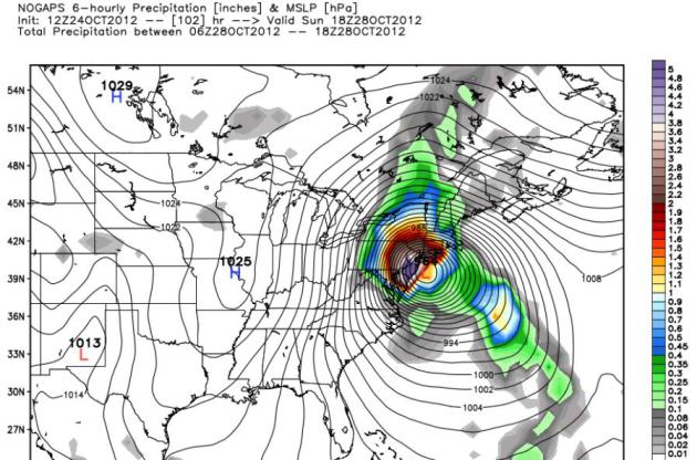
NOGAPS Solution. The Navy’s NOGAPS model is even more
troubling, suggesting a New York City landfall, and earlier, closer to
Sunday afternoon – with hurricane force winds from the Delaware Valley
to Hartford and Providence, and potentially major damage from Long
Island to Providence to Cape Cod.
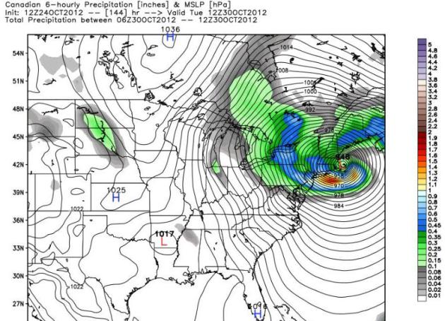
Canadian (GEMS) Model. To demonstrate the wide range of
solutions, the Canadian model shows landfall closer to Cape Cod and the
Boston area next Tuesday morning.
GFS Solution. The GFS model was whisking Sandy out to sea
yesterday. No more. Now it’s coming into line with ECMWF, NOGAPS and the
GEMS model, hinting at landfall near Portland, Maine Tuesday evening.
Summary: Every hurricane or potential hurricane brings its
fair share of frustrations. Sandy is no different. Confidence levels are
now moderate to high that the northeastern USA will be impacted by a
significant hurricane or a hurricane-nor’easter hybrid, still capable of
very significant wind and water damage. What is more problematic is a
specific landfall prediction.
Facilities and staff from the Outer
Banks to D.C. and Richmond to New York, Cape Cod and Portland need to be
on alert for a possible hurricane-like storm, arriving as early as
Sunday; a Monday-Tuesday landfall seems more likely right now.
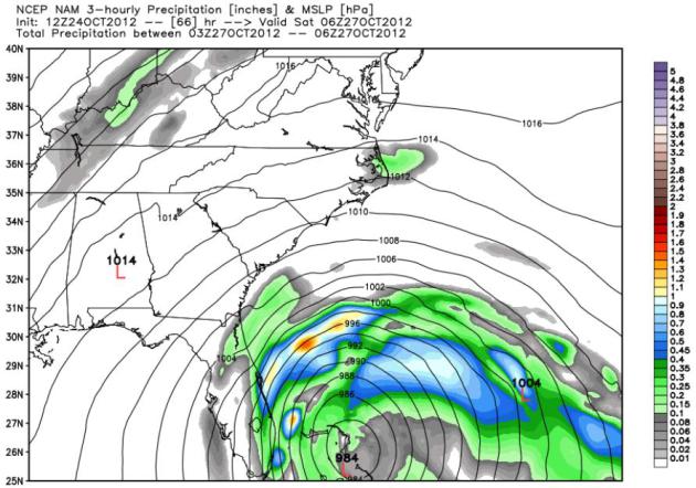
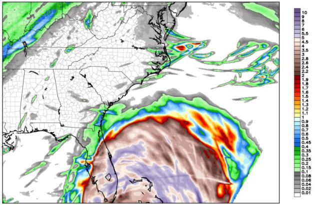
Major Impacts Into Friday:
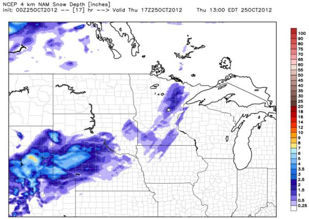
Flooding Rains for Florida. The map above (4 km.
NAM model) shows total rainfall by Friday afternoon, some 5-10" amounts
possible from Miami northward to Cape Canaveral.
Storm Surge. The chart above, courtesy of
stormsurf.com,
shows expected swells at a weather buoy east of Cocoa Beach, Florida on
Friday - as high as 40 feet as Hurricane Sandy sweeps north.
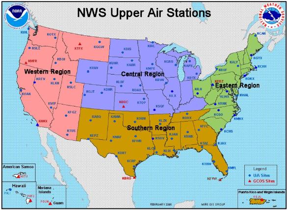 Special Balloon Launch
. NOAA
is
launching weather balloons with greater frequency in the coming days.
The reason? To improve the data set that goes into the supercomputer
simulations, trying to pinpoint track and intensity for Sandy. Would
they do this for a major blizzard in the Midwest? I'd like to think so.
More from NOAA
via
FB: "
Therefore, it was announced today that beginning Thursday, October 25th,
all NWS upper air sites in the contiguous US (Eastern, Southern,
Central, and Western regions) will be performing special balloon
releases every 6 hours over the next several days. During normal
day-to-day operations, upper air sites release weather balloons every 12
hours. This is the first time in our office’s history that the *entire*
CONUS will participate in special 6-hourly balloon releases in support
of tracking a significant weather system. In August 2011, only NWS
offices located east of the Rockies participated in special 6-hourly
balloon releases to improve forecasts for Hurricane Irene..."
Could A Superstorm Occur In The Next 7 Days? The
short answer is yes, based on the data and models I'm looking at. Here's
an excerpt of a post from meteorologist Marc Weinberg at
wdrb.com: "
Tonight
I am going to write a more technical blog than I normally do when the
weather is quiet. Many times, I write the more technical blogs during
severe weather, but tonight offers a unique opportunity as some data
suggests a Superstorm could occur over the next 7 day in the US.
Superstorms are anomolously powerful low pressure systems that form
when unique conditions occur with perfect timing creating a monster. An
example of a Superstorm is the 1993 blizzard that produced tornadoes on
the Gulf Of Mexico and over 40" of snow from North Carolina through
the northeast. Another Superstorm was the infamous "Perfect Storm" that
phased hurricane Grace and a powerful low pressure in the mid
latitudes to create a monster storm. The pressure on "The Perfect Storm" was 972 mb.
The wave heights off shore during The Perfect Storm were over 100 feet!
These weather freak shows are very unique and don't occur very often
because such unique conditions must phase at exactly the perfect time.
True Superstorms are really once in 25 year (or so) events..."
Halloween Scare? Hurricane Sandy Shows Similarities To "Perfect Storm". Here's an excerpt from a story at The
Christian Science Monitor: "...“
You
can have hurricane force winds and not have a hurricane,” says Feltgen.
“There can be some powerful nor’easters.” In a worst-case scenario,
there could be travel disruptions early in the week from southeast
Virginia all the way to New England, says Mr. Walker. Because the winds
could be driving large seas in from the ocean, coastal areas could
experience flooding. If the storm does head inland, the computer models
show it slowing down. This could potentially result in a lot of
flooding. In addition, some of the computer forecasts predict snow in
the mountains of western Pennsylvania up to western New York state. “A
high pressure zone building on the back of this would funnel down cold
air from James Bay onto the back side of this system,” says Walker..."
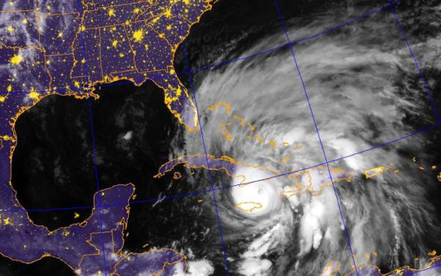
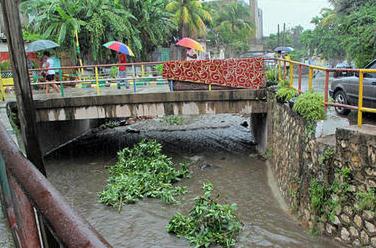
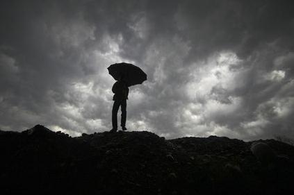
Photo credit above: "
Rain brought by the outer bands of
tropical storm Sandy, which is now a Category 1 hurricane, fall in the
Standpipe neighborhood of Kingston, Jamaica, Tuesday." David McFadden/AP
Active Weather Threat - Halloween Week Nor 'easter. The
Philadelphia office
of The National Weather Service does a good job of assessig the risks
posed by "Sandy" for the Delaware Valley and much of the northeast.
Click here to read the pdf.
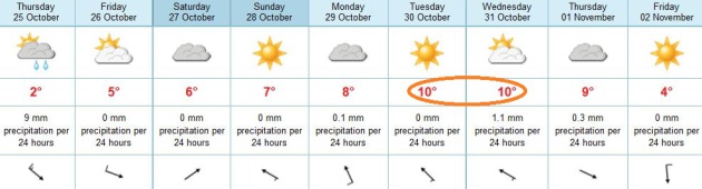
 Paul's Conservation Minnesota Outlook for the Twin Cities and all of Minnesota:
TODAY: Heavy rain may change to wet snow before tapering. Windy
and much colder. Winds: NW 20+ High: 39 (coating of slush on some lawns and fields? Roads stay wet).
THURSDAY NIGHT: Partly cloudy and chilly. Low: 31
FRIDAY: Chilled sunshine, heavy jackets return. High: 43
SATURDAY: Cool sun, less wind. Low: 27. High: 42
SUNDAY: Blue sky, hints of November in the air. Low: 28. High: 44
MONDAY: Clouds increase PM hours. Low: 29. High: 47
TUESDAY: Partly sunny, milder breeze. Low: 33. High: 52
WEDNESDAY (Halloween): Clouds thicken, late shower? Low: 37. High: 50
Climate Stories...
Why Climate Change Has Become The Missing Issue In The Presidential Campaign.
Time Magazine
takes a closer look at why both candidates may be (intentionally)
glossing over the risks associated with burning ever more fossil fuels.
Does "energy independence" trump...everything? We hear so much about the
perils of fiscal debt and the growing whopper of a deficit - much less
about the moral disconnect associated with growing levels of
environmental debt we're leaving to our kids and grandkids. Here's an
excerpt: "...
But it’s still notable that in the debates, Obama
hasn’t brought up global warming on his own, even at moments when it
would have helped explain some of his actions over the past four years.
In the second debate, for example, after a questioner asked him about
what his Administration was doing to about high gas prices, Obama
managed to talk about energy for minutes without mentioning the need to
eventually reduce carbon emissions, beyond a paean to energy
efficiency. When the Keystone XL pipeline came up, Obama didn’t talk
about the effect that increased U.S. dependence on Canadian oil sands
might have on global carbon emissions. Once again, climate change was
missing in action. In the end, though, it’s difficult to blame either
candidate for dropping climate talk in this election. Beyond committed
environmentalists, there hasn’t been much evidence that Americans even
want to think about global warming, much less vote on it. But the job
of a leader — or someone who is applying to become a leader — should
involve telling the occasional difficult, even inconvenient truth.
That’s been missing in this campaign." Photos above: AP.
Obama, Romney Ignore Climate Change, But So Do Voters. Here's a clip from a story at
The Christian Science Monitor: "
In
four years, climate change has gone from the elephant that blind men
are trying to describe to the elephant in the room. No one wants to talk
about it. With a few exceptions, voters don't ask. And presidential
candidates don't tell. Now that the 2012 presidential debates are over,
commentators have begun to take notice. Not once during the three
presidential encounters or the single vice-presidential debate did the
subject come up. "National elections should be a time when our nation
considers the great challenges and opportunities the next President
will face," opines the website ClimateSilence.org,
a project of Forecast the Facts and Friends of the Earth Action aimed
at pushing the issue into campaigns. "But the climate conversation of
2012 has been defined by a deafening silence..."
From "Frontline", A Look At The Skeptics' Advance. The New York Times takes a closer look at the Frontline (PBS) documentary on climate denial that first aired Tuesday night; here's an excerpt: "
Less
than 24 hours after the final presidential debate ended with the words
“climate change” left unsaid, PBS aired a report that essentially
explains the omission. “Climate of Doubt,” a “Frontline” documentary
presented on Tuesday night, probably allots the biggest single block of
national airtime to climate skeptics like Myron Ebell of the Competitive Enterprise Institute, Tim Phillips of Americans for Prosperity and S. Fred Singer
than we’ve seen in a long time. Very little of the production is about
the science of climate change. The focus is rather on the ideology and
political heft of the skeptics’ movement, and the way it found new
life as the economy fell to pieces and the Tea Party arose from the
wreckage..."
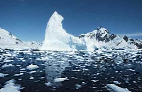 U.S. Looks To Old Arctic Ship Logs For Climate Change Clues
.
Reuters has the story; here's an excerpt: "
Using
citizen scientists to transcribe thousands of pages of logbooks from
Navy, Coast Guard and other ships from 1850 to World War Two will fill a
big data gap, NOAA Administrator Jane Lubchenco said.
Scientists in recent decades have gotten weather data from satellites
and ground observations, and such tools as ice samples show ancient
patterns, she said. But the archived logs could establish a baseline of
historical weather data. "Naval and
Coast Guard records are an invaluable window into the past which will
let us know what it was like then," she told Reuters after a news
conference. NOAA scientists have said
that the Arctic is undergoing dramatic change as world temperatures
climb. Arctic sea ice shrank to a record low of 1.32 million square
miles (3.41 million square kilometers) by mid-September."
Could The Solution To Global Warming Be More Chemicals? Sounds like a great idea to me? Time to buy more Dow Chemical stock...? Here's an excerpt of a story at
usnews.com: "
Could
the answer to global warming actually lie in putting more chemicals
into the atmosphere? A growing number of climatologists and engineers
believe that "geoengineering" — putting reflective aerosols into the
atmosphere — may be the most cost-effective way of reversing global
climate change. In a study released earlier this week, California
Institute of Technology scientists say that "solar radiation
management" — essentially "turning down the sun" by artificially
reflecting some of the sun's rays back into space — could be used to
change the climate back to "pre-industrial" levels. According to the
report, by reducing the sun's rays just .5 percent, the entire Arctic
sea ice extent could be recovered..."


No comments:
Post a Comment