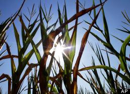
65 F. high in the Twin Cities Tuesday.
55 F. average high for October 23.
58 F. high on October 23, 2011.
.08" rain fell yesterday with scattered T-storms between 3-7 am.
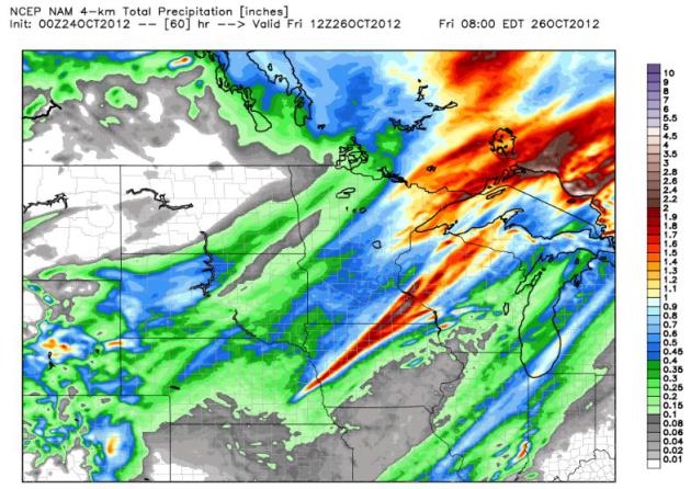
.52" rain predicted for the Twin Cities by midday Thursday. 00z NAM model.
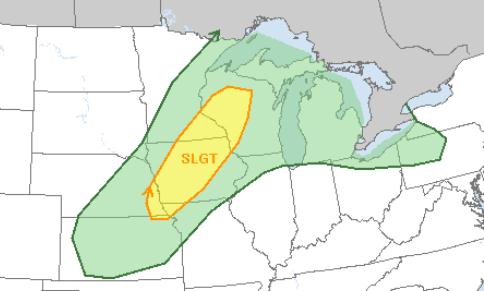
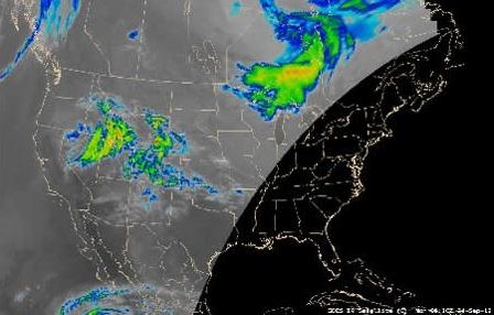
Slight Severe Threat Today. A few strong/severe storms are possible this afternoon - best chance south/east of MSP. Details from SPC below.
Election Day Forecast. Will weather be a factor -
heavy rain/snow capable of giving Republicans an edge at the polls? A
highly speculative November 6 weather map below.
"
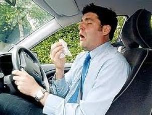
Having a cold dulls your reflexes and slows you down. Alcohol
impairs your judgment and so can a head cold," he said. "With a cold,
it's like your brain is stuck in first gear and it's not reacting as
quickly as it should." - excerpt from a story at alertdriving.com below, showing how driving with a cold can be as dangerous as driving drunk.
Slight Severe Risk.
SPC
has a slight threat of hail and damaging wind gusts from Eau Claire and
the Twin Cities to Rochester, Des Moines and Omaha. Watches and
warnings may be issues this afternoon and evening; best chance
south/east of the Twin Cities.
Potentially Significant Rain For Southeastern Minnesota? The 4 km NAM model prints out some 1-1.5" amounts later today into Thursday morning, closer to .3 to .5" for central Minnesota.
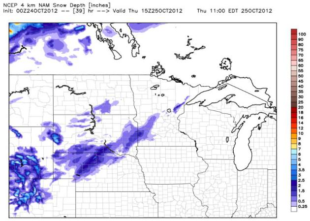
Slush Potential. The same 4 km NAM shows a cold rain
ending as a coating to an inch of slush in a fairly narrow band from
near Marshall and Windom to Wadena and the Duluth area by midday
Thursday. We'll see.
Nothing to Sneeze At
Today's eye-opening weather nugget: driving with
a cold can be as dangerous as driving drunk. Americans get bogged down
with 1 BILLION colds every year, and a story on today's weather blog
shows how a single 3 second sneeze, while sailing down the freeway at 70
mph, takes your eyes off the road for 315 feet. Not good. Decongestants
can leave you woozy and disoriented - a car accident waiting to happen,
according to UK research.
Lovely.
Enjoy one more mild day today; a few T-showers
by evening as a vigorous cold front approaches. A few severe storms may
bubble up - especially south/east of MSP. Half an inch of rain falls
tomorrow morning as a chilling wind howls. By the time it's cold enough
aloft for snow moisture will have moved on. Timing.
Rescue heavy jackets from cold storage; highs struggle near 40 Friday into early next week.
The jury is out on "Sandy", expected to become a
hurricane, churning up the east coast of the USA. Some models shove it
out to sea, but the ECMWF and Navy NOGAPS model hooks the hurricane into
Long Island and New England Sunday night or Monday. Landfall risk? 1 in
3.
Yes, storms with names put our Minnesota cold fronts into stark perspective.
Driving With A Cold Is As Dangerous As Driving Drunk. Really? This story from
realage.com caught my eye; here's an excerpt: "
If your nose looks like a radish and your eyes are more watery than chicken soup
at a bad diner, the only equipment you should be operating is a
thermometer. The common cold, it turns out, is a car accident waiting to
happen. The sneezing, tearing, fever, and puffy eyes make your
reactions behind the wheel as slow and unsteady as a party-goer driving
drunk, reports a United Kingdom team. One reason: A single sneeze lasts
2 to 3 seconds and your eyes automatically close during the action. If
you’re driving 70 miles an hour and go ah-ah-ah-choo, you’re driving
blind for 315 feet. You don't need us YOU Docs to tell you that's
scary. It also explains something we didn’t understand in the past: why
getting a flu shot decreases car accident deaths. Here are 6 more reasons why you should get a flu shot this year..."
Photo credit courtesy of
alertdriving.com, which has more details on the UK study.
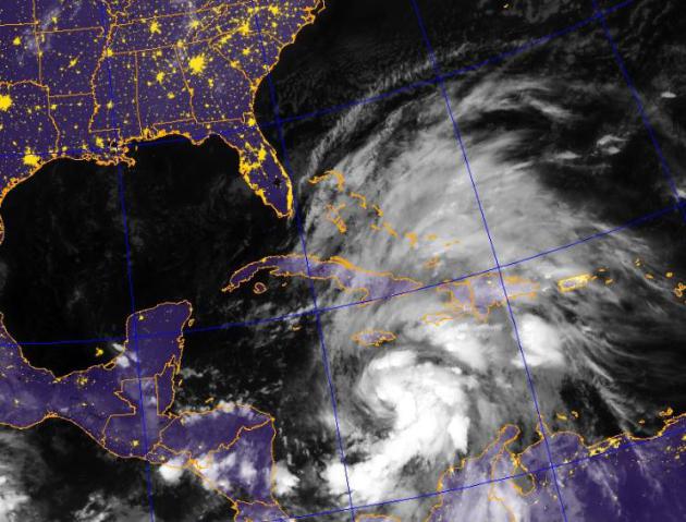
Yesterday I talked about a 35% possibility of Hurricane Sandy
impacting the east coast of the USA by Sunday-Monday of next week.
This morning the odds have increased to 45%,
and my concern about a possible U.S. landfall is slowly increasing over
time. It is by no means a “sure thing”, but some of the models that
pushed “Sandy” out to sea yesterday are now re-curving this (potentially
very significant) hurricane northwestward, toward New York City, Long
Island and southern New England by late Sunday.
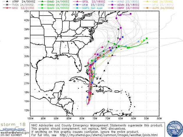
Model Ensemble. The map above shows all the weather models, and their respective solutions for the track of “Sandy”.
As you can see roughly 2/3rd of the models now suggest an eventual turn toward New England or the Mid Atlantic coast.
Navy NOGAPS Model. This high-resolution model closely
resembles the ECMWF (European) model, which was the first simulation to
turn “Sandy” toward the northeast coast. The map above is valid 1 am
Monday, showing a possible landfall near New York City. If (a big if)
this solution verifies the worst flooding and beach erosion would take
place north/east of Hurricane Sandy’s track, from Long Island to
Providence to Cape Cod.
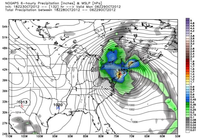
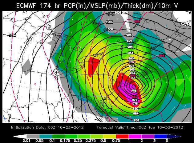
ECMWF Solution. The European solution has seen a northwestward
hook to Sandy for the last 2-3 days. It was the first to suggest that
Sandy would not push out to sea, but turn toward the USA, and that
solution continues with the latest model run, suggesting landfall near
Long Island. The map above is valid 1 am Tuesday morning.
Storm Timeline:
Thursday night – Friday: Florida (beach erosion and coastal flooding on Atlantic side of Florida, from Miami northward to Jacksonville)
Friday: Carolinas. Outer Banks should see the worst of the storm with 50-85 mph winds, and some beach erosion.
Saturday: Mid Atlantic coast.
Sunday – Monday: New Jersey, New York City metro area, Long Island and southern New England.
This is a rough timeline, and may change as new
data arrives. Here’s the bottom line: the odds of Sandy impacting the
east coast of the USA have increased (slightly) in the last 24 hours.
Beach erosion and coastal flooding may be significant along the east
coast, but the worst conditions may take place from the New York City
and Long Island into southern New England.
Monster East Coast Storm Next Week or Big Miss? Meteorologist Jason Samenow at The Washington Post's
Capital Weather Gang weighs the evidence (and conflicting models) in this post; here's an excerpt: "
A
few computer models have conjured up a storm of epic proportions for
the mid-Atlantic and/or Northeast next week. But before anyone presses
the panic button, other models keep the storm out to sea.
Because of the pre-storm hype resonating through social media streams,
let’s clear the air by answering some basic questions and sharing some
expert opinions... How likely is a big storm? The pieces are there for a big storm, the question is whether and where they come together. Based on current information, I’d
give slightly better than 50 percent odds that a significant storm
impacts some place in the mid-Atlantic and/or Northeast early next week,
but just a 20 percent chance of a storm affecting Washington, D.C.
directly. A landstrike north of Washington, D.C.’s latitude appears to
be more likely than south. So this could end up being a bigger deal in
New England than the mid-Atlantic...."
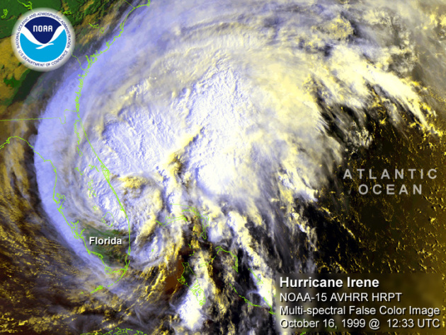
Irene Analysis Finds Weather Service Flaws. Do
meteorologists, government and private, consistently underperform when
it comes to predicting inland flooding from tropical storms and
hurricanes.
The Times Union takes a look; here's a clip: "
A yearlong federal report on the National Weather Service's
performance during Tropical Storm Irene concluded the agency needs
more accurate and timely methods to determine the risks of inland
flooding. The report also found that information about the storm's
risks that was provided to the public and news media proved difficult
to comprehend. The 129-page report by the National Oceanic and Atmospheric Administration
contains more than 80 recommendations for the weather service to
adopt. The report's authors were quick to state that, as a whole, they
believe the NWS performed admirably during the storm, but that Irene
exposed flaws that, if corrected, could save lives should a storm
similar to Irene strike again..." Image: NOAA.
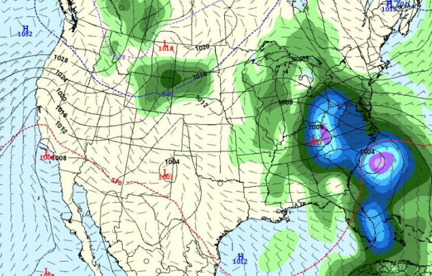
Election Day Preview.
Please don't share this with David Axelrod, President Obama's Chief
Advisor. A cold rain is predicted from the Carolinas into (gasp) Ohio,
the state that may determine the election. Light showers may fall on the
Great Lakes, wet snow from Montana into the Dakotas. Will soggy weather
tip the scales in favor of Gov. Romney? Place your bets. Map above:
NOAA's GFS solution valid Tuesday evening, November 6.
No Weather Too Scary For Original Storm Chasers. Here's an excerpt of a very interesting article at
nky.com: "
Sixty-five
years ago, a group of high-flying storm chasers in Wilmington wrapped
up a groundbreaking research project. Never before had people flown
airplanes into the heart of thunderstorms to study their causes and
characteristics. That was the goal in the summers of 1946 and 1947,
first in Florida, then in Wilmington. “No storm was to be avoided
because it appeared too large or too violent,” Roscoe R. Braham Jr.,
the project’s senior analyst, said many years later at a meteorology
conference..."
Photo credit: "
Some of the men who worked on the project - eager to learn, willing to work, and dedicated to developing a career in meteorology."
GOES-13 Satellite Returns! Back from the dead - or nearly dead. It's a miracle!
Earthsky.org has more details: "
As reported in previous stories,
the GOES-13 weather satellite experienced many issues in September
2012 that forced NOAA to temporary replace the satellite. GOES-13 was
offline for some weeks, and no one knew if it would return. But now it
has! Back in September, GOES-13 experienced a lot of noise, which
eventually resulted in the repair of the sounder and imager
instruments. In order for GOES-13 to be fixed, NOAA decided to grab the
GOES-14 satellite to temporarily replace GOES-13. In fact, during the
month of October, NOAA was slowly drifting the GOES-14 satellite into
GOES-13′s current position. However, this transition is no longer
needed, as GOES-13 – whose function is to provide visible/infrared
images and various weather measurements for the eastern U.S. and
Atlantic Ocean – is back..."
Image credit above: "
When GOES-13 went on standby. Image via CIMSS Satellite Blog."
Monitoring Global Precipitation Using Satellites.
Satellites are revolutionizing not only the tracking of hurricanes, but
how we detect excessive rain and snow around the planet, and initialize
weather models. Here's a snippet of a story at
SPIE Newsroom: "
Floods
caused by extreme precipitation are one of the most frequent and
widespread natural hazards. They are more costly and dangerous than
ever, as population in urban areas increases and the global climate
becomes more extreme and variable. Data shows that each year there are
more than a hundred million people affected by flood events with a cost
of more than $100 billion. While accurate precipitation monitoring is a
key element for improving flood forecasting, traditional means of
precipitation observation, such as ground-based gauges and radars, are
limited in their spatial coverage. Recent advances in satellite remote
sensing techniques have enabled precipitation observation in remote and
ungauged regions to help hydrologists better forecast floods and
manage water resources..."
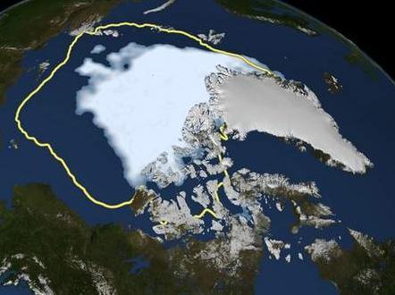
Arctic Could Wreak Havoc On Florida's Weather. Say
what? Teleconnections - incredibly complex linkages, planetwide. That's
what meteorologists (and climate scientists) are detecting. Changes in
the Arctic can have a domino effect, 5,000 miles south, as described in
this article at the
Herald-Tribune; here's an excerpt: "
Forecasters
say winter in Florida and along the southeastern U.S. coast will be
wetter and a tad cooler than normal, but an unprecedented loss of
Arctic sea ice this fall could wreak havoc with that prediction. The
experts made almost the same long-range forecast three years ago, based
on Pacific Ocean temperatures similar to those expected to develop
this year. But instead of a mild chill, Florida got record-breaking
cold weather that winter. If such extremely cold weather hits Florida
again this winter, some scientists say the blame may lie nearly 3,000
miles away — in the Arctic Ocean. Sea ice there dropped to its lowest
level ever recorded in September, shattering the previous mark set in
2007 by 16 percent..."
Image credit above: "
This Sept. 16, 2012, image released
by NASA shows the amount of summer sea ice in the Arctic, at center in
white, and the 1979 to 2000 average extent for the day shown, with the
yellow line. Scientists say sea ice in the Arctic shrank to an all-time
low of 1.32 million square miles on Sept. 16." (AP Photo/U.S. National Snow and Ice Data Center, File)
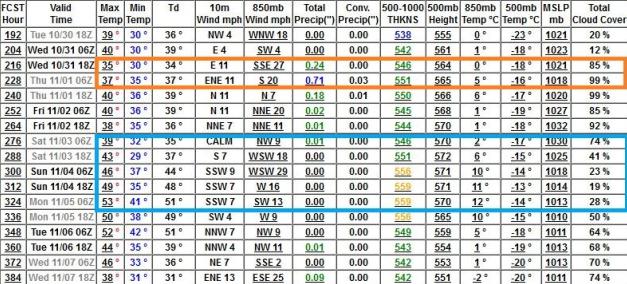
 "Ask Paul".
 Weather-related Q&A:
"
I am a huge fan of Paul Douglas's blog! Thanks for all you do
Paul, I love your enthusiasm for weather. I share in that enthusiasm and
like to keep up to date on the weather forecast and the various model
outputs. I want to ask you where you get the model data from the
GFS that breaks it down in 3-hour increments. I am attaching the graphic
you frequently reference as an example. I love this format and would
love to have access to view this model output on my own.
Thanks again for all you do!"
David Gregoria
David - thanks for a nice note
and kind words; very much appreciated. Would you call my Mom and repeat
what you said to her? Just to get her off my back for a day or two? The
link in question, looking out 16 days, is from MeteoStar, and you can
click over to it
here. Keep in mind once you get beyond 5-7 days it's more voodoo than science.
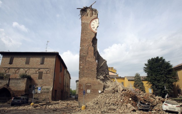
"Paul:
Does it make you nervous that an Italian court convicted seven
scientists for failing to adequately warn residents of an earthquake?
You better make sure your weather forecasts are accurate!"
Don Haberman
Orono
Don - breathing makes me
nervous; the Italian verdict is ridiculous, bordering on the absurd.
There is no way to predict earthquakes, in advance. Zero skill. Once a
quake strikes you can (sometimes) give a few seconds notice before the
shock wave arrives. And getting to the heart of your question, no
meteorologist (that I'm aware of) has ever been prosecuted for a "bad
forecast". The courts have ruled that meteorologists are liable for
maintaining weather-related equipment, but suing a forecaster for a
lousy prediction would be pouring good money down a deep drain. Then
again in this country anybody can sue anyone for any reason. As in
anything future-related, there are no guarantees. That goes for
economists, doctors, CIA analysists and palm readers, come to think of
it.
"
The idea is ridiculous, to
hold scientists responsible for public policy," said Chris Goldfinger, a
professor of geology and geophysics at Oregon State University.
"First, scientists have almost zero ability to predict earthquakes, and second, have no direct responsibility for public policy. Something has gone seriously wrong in the Italian legal system."
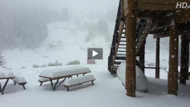
... Here's a (very) cool video clip from
Mission Ridge Ski and Board Resort: "
You
know it's time to wax the board and tune the skis when... you get 8
inches of new on Oct. 22 ... you feel the need to take a video of snow
... you giggle uncontrollably ... you have to push your car out of the
snow to get home from work ... it's STILL snowing. — with Josh Jorgensen at Mission Ridge Ski & Board Resort."
Looks Like Winter. Here are some of the highest western snowfall totals, courtesy of Chad Merrill at Earth Networks:
30" Prosser Creek Reser, California
22" Alpine Meadows, California
18" Mt. Rose Ski Area, Nevada
16" Soda Springs, California
9" Hungry Horse, Montana
4.5" Montpelier, Idaho
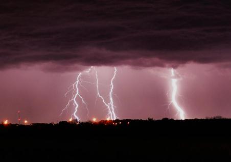
Enlightening. Donna Wick Paul took this photo near Piqua, Ohio on Monday as strong T-storms rolled thru town.
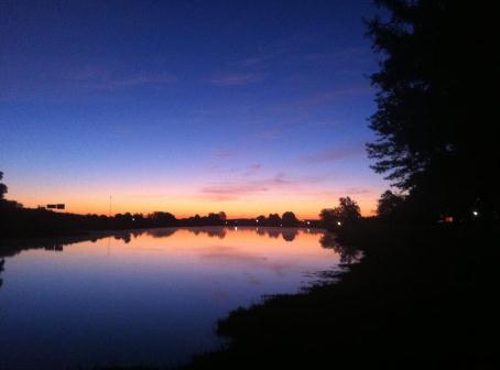
Serenity.
The National Weather Service in Columbia, South Carolina fielded this photo of a memorable sunrise.
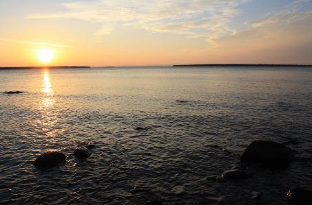
A Superior Sunset. Migizi Gichigumi snapped this photo of the Apostle Islands on Lake Superior Monday evening: "
the overcast skies cleared this evening for a beautiful sunset over lake superior and the apostle islands!"
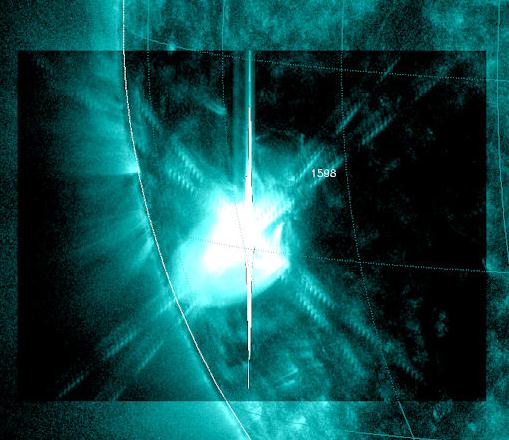
New X-Flare On The Sun. Northern Lights Imminent? We
won't have much chance of spying the aurora until Thursday night, again
Friday night, but with all the solar flares being reported in recent
days it might be worth a look, especially if you can get away from light
pollution and give your eyes a chance to adjust.
Spaceweather.com has more details: "
New
sunspot AR1598 has erupted again. On
Oct. 23rd at 0322 UT, Earth orbiting satellites
detected a strong X1-class
solar flare. NASA's Solar Dynamics
Observatory recorded the extreme
ultraviolet flash. Radiation from the flare created waves
of ionization in the upper atmosphere over Asia
and Australia (the daylit side of Earth) and
possibly HF radio blackouts at high
latitudes. The blast did not, however,
produce a significant coronal mass
ejection (CME). No auroras are expected to
result from the blast..."
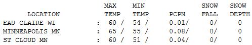
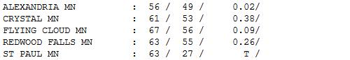 More Like Late April
.
It didn't feel like late October out there yesterday. After a thundery
start clouds, fog and mist lingered much of the day, as much as .38"
rain fell at Crystal. Highs ranged from 56 at Alexandria to 60 St. Cloud
to 65 in the Twin Cities.
 Paul's Conservation Minnesota Outlook for the Twin Cities and all of Minnesota:
TODAY: Mostly cloud and mild, few T-storms, some severe? Winds: SE 5-15. High: 68
WEDNESDAY NIGHT: Showers, possible thunder. Low: 42
THURSDAY: Gusty - a cold rain tapers, clearing late. High: 44
FRIDAY: Partly sunny and brisk. Low: 28. High: 41
SATURDAY: Plenty of sun, cooler than average. Low: 26. High: near 40
SUNDAY: Mix of clouds and sun, still chilly. Low: 29. High: 42
MONDAY: Sunny start, high clouds increase. Low: 31. High: 43
TUESDAY: Patchy clouds, still quiet. Low: 32. High: 44
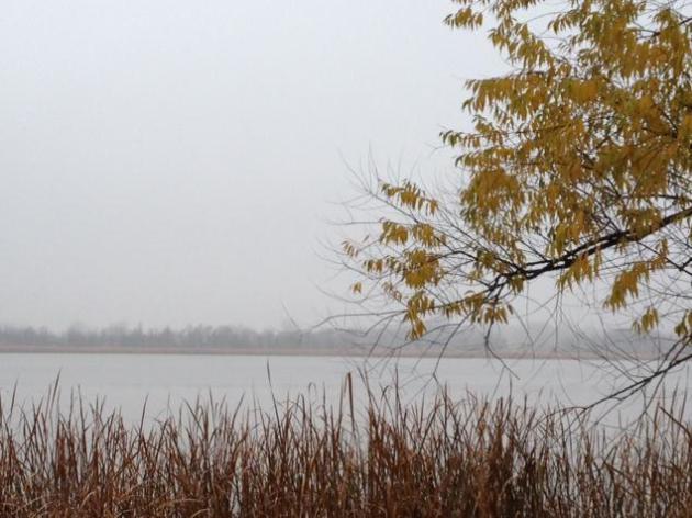
* photo above of Benton Lake (near Cologne) courtesy of WeatherNation TV meteorologist Bryan Karrick.
Climate Stories...
Climate Change Was Shut Out Of The Debates For The First Time In 24 Years.
Slate.com has more: "...
Needless
to say, climate change remained one of the "things we didn't get to"
last night, marking the first time that the topic didn't make an
appearance in the round of presidential and vice presidential debates
in more than two decades, and providing the latest example of how green
issues have been largely left out of this year's election.
For those of you who are wondering, the first time climate change
came up in a debate was during the 1988 VP match-up between Lloyd
Bentsen and Dan Quayle..."
Food And Climate: A New Warning. Here's the introduction to a story at
The New York Times Environmental Blog: "
As we have noted many times, one of the major questions about climate change is what it will do to the world’s food supply.
Competing factors are at work. On the one hand, the rising level of
carbon dioxide in the air significantly bolsters the growth of plants,
potentially raising yields. Conversely, rising heat and, in some
places, additional weather extremes like drought and heavy rains
threaten to reduce yields. Climate contrarians like to cite
the upside potential of rising carbon dioxide while largely ignoring
the risks. And early research, often done under artificial conditions,
did indeed suggest the gains were likely to outweigh the losses. But a
growing body of research conducted under more realistic field conditions
suggests the opposite may often be the case..." Photo: AP.


No comments:
Post a Comment