52 F. high in the Twin Cities Wednesday.
61 F. average high for October 10.
76 F. high on October 10, 2011.
2.5" snow fell on the Twin Cities on October 10, 1977.
.84" rain predicted for KMSP by Sunday morning at 7 am. 00z NAM model.
6th most active Atlantic hurricane season on record. Source: NHC.
15 tropical storms.
8 hurricanes
1 major hurricane (Michael).
3 tropical storms impacted the southeastern USA, Category 1 Hurricane Isaac hit Louisiana in late August.
Today is National Take Your Teddy Bear To Work Day. Why would I make it up?
Details (how bored are you?)
4. Twin Cities is the 4th most educated metropolitan
area in the USA, behind Washington D.C., Boston and San Francisco.
Details from
The Washington Post.
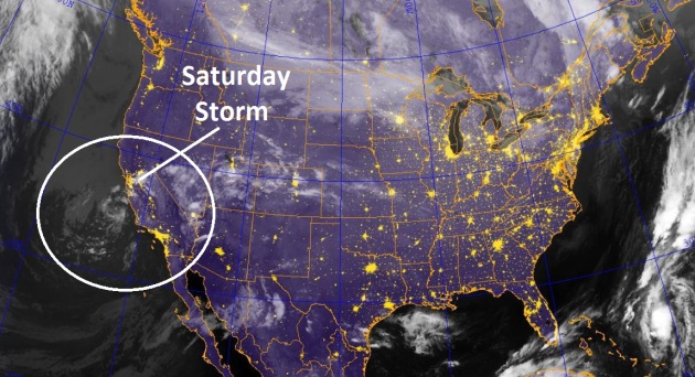
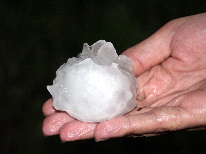
Change In The Weather. The pattern is about to
shift, hopefully an omen of a wetter regime to come. The storm hovering
off the coast of California doesn't look very impressive (although it
did produce 3" of hail on the ground near Gilroy). As it pushes east
counterclockwise winds will suck up Gulf moisture and push it northward
Friday and Saturday, setting the stage for what may be the most
significant rain since mid-August. Satellite image:
Naval Research Lab.
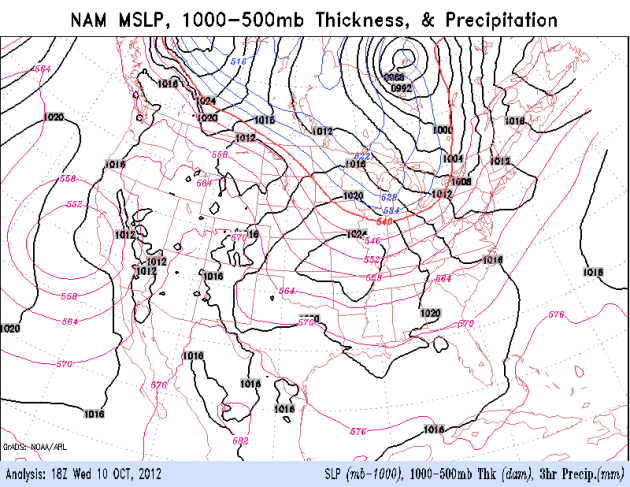
A Real Storm? For the past few weeks it's been a
parade of wimpy clippers, a few spits of rain, a hair-tussing wind,
these bursts of chilly, Canadian air in quick succession, limiting any
subsequent warming. The jet stream buckles late week, allowing a
developing storm over California to push into the Plain states, fueled
by southern moisture, spreading a smear of moderate rain into the Upper
Midwest and Great Lakes over the weekend. Loop: NOAA.
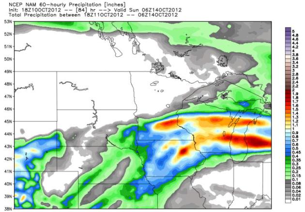
Potentially Significant. It's still too early to get
specific about where the heaviest rain bands may set up on Saturday,
but the 84-hour NAM model shows a 1 to 1.6" bullseye from Willmar into
the northern suburbs of the Twin Cities. I suspect most towns will pick
up at least a half inch, a few lucky lawns and fields may wind up with
over an inch of rain.
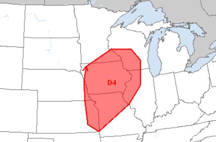
Severe Saturday? High dew points, coupled with ample
wind shear and marginal instability may spawn a few severe storms south
and east of the Twin Cities Saturday, a better chance of large hail
from Kansas City and Des Moines to Madison. Map: NOAA SPC.
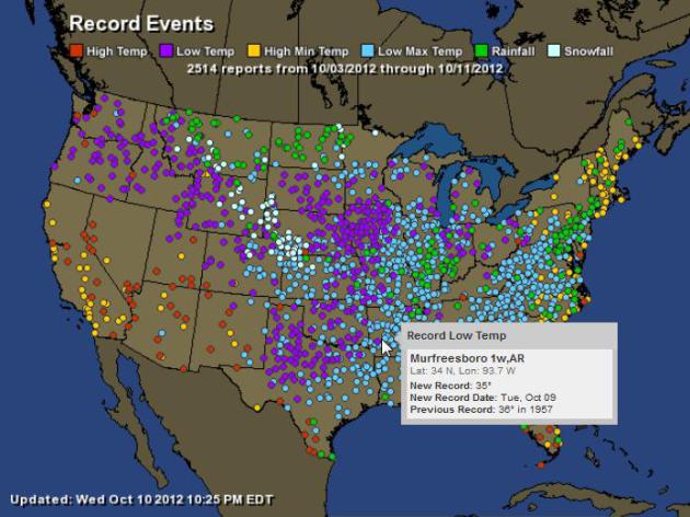
Early Jackets. In the last week NOAA reports 2,514
records, most of them record lows east of the Rockies. Record heat
continues over the southwestern USA. For details click on an interactive
map from
Ham Weather.
"...
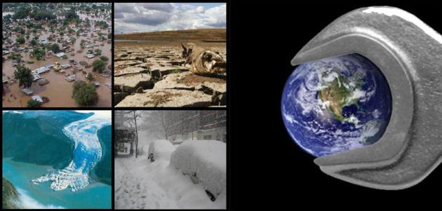
Some 61 percent of Americans indicated U.S. weather has
gotten worse in the past several years, up 9 points from March. Looking
at local weather, 56 percent of those in the South say it has gotten
much or somewhat worse over the past few years, while half of
Midwesterners, 43 percent of Westerners and 42 percent of those in the
Northeast said the same..." - from a story about climate change,
extreme weather, and evolving American opinions on climate change in a
Live Science article, details and links below.
Report: Climate Change Behind Rise In Weather Disasters. Here's an excerpt from a story at
USA Today: "...
The
report finds that weather disasters in North America are among the
worst and most volatile in the world: "North America is the continent
with the largest increases in disasters," says Munich Re's Peter Hoppe.
The report focuses on weather disasters since 1980 in the USA, Canada,
Puerto Rico and the U.S. Virgin Islands. Hoppe says this report
represents the first finding of a climate change "footprint" in the data
from natural catastrophes.
Some of the report's findings:
-- The intensities of certain weather events in North America
are among the highest in the world, and the risks associated with them
are changing faster than anywhere else..."
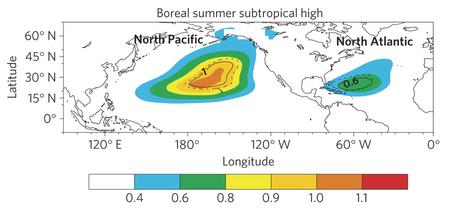
Intensification Of Northern Hemisphere Subtropical Highs In A Warming Climate.
This may explain the unusually persistent heat-pump high that set up
shop over America's mid-section this past summer; here's an excerpt of a
new paper at
Nature Geoscience: "...
The
simulations suggest that these summertime highs will intensify in the
twenty-first century as a result of an increase in atmospheric
greenhouse-gas concentrations. We further show that the intensification
of subtropical highs is predominantly caused by an increase in thermal
contrast between the land and ocean. We suggest that summertime
near-surface subtropical highs could play an increasingly important role
in regional climate and hydrological extremes in the future."
*
more details on the implications of a stronger, more persistent Bermuda High for the USA from Climate Central below.
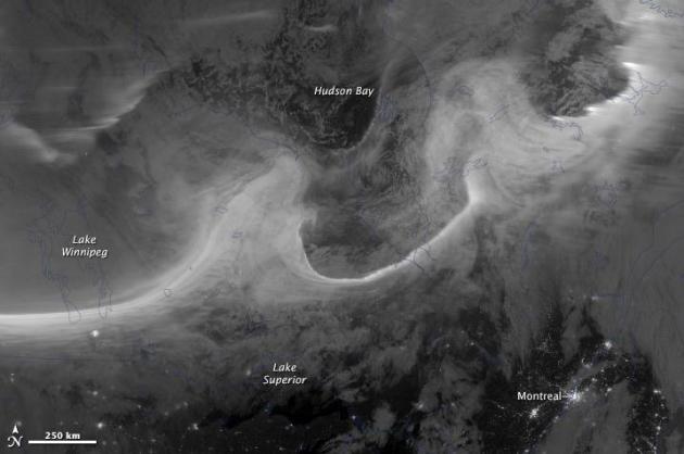
NASA Tracks Spectacular Aurora. Here's more information on the remarkable image above, courtesy of
NASA's Earth Observatory: "
Overnight
on October 4-5, 2012, a mass of energetic particles from the
atmosphere of the Sun were flung out into space, a phenomenon known as a
coronal mass ejection. Three days later, the storm from the Sun stirred up the magnetic field around Earth and produced gorgeous displays of northern lights. NASA satellites track such storms from their origin to their crossing of interplanetary space to their arrival in the atmosphere of Earth. Using the “day-night band” (DNB) of the Visible Infrared Imaging Radiometer Suite (VIIRS), the Suomi National Polar-orbiting Partnership
(Suomi NPP) satellite acquired this view of the aurora borealis early
on the morning of October 8, 2012. The northern lights stretch across
Canada’s Quebec and Ontario provinces in the image, and are part of the auroral oval that expanded to middle latitudes because of a geomagnetic storm..."
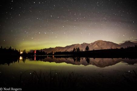
A Celestial Sight. Thanks to Noel Rogers and
Bow Valley Photography for sharing this photo of the Northern Lights above the Rocky Mountains, snapped at Canmore, Alberta.
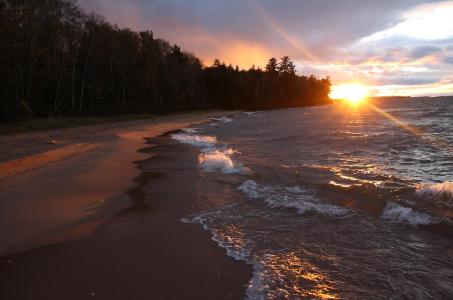
Fast-Forward Fall. Migizi Gichigumi snapped this
photo
near Sand Bay, Wisconsin, cold exhaust on the backside of a vigorous
Alberta Clipper whipping up some nice breakers on Lake Superior.
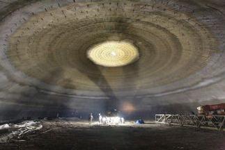
Domes Give Shelter From The Storms. Here's a growing
industry: personal protection for (increasingly) severe weather around
the USA. With the right shelter you can survive a major hurricane, an
earthquake, even a half-mile-wide tornado.
The Houston Chronicle has the story; here's an excerpt: "
Federal
emergency management officials have appropriated $50 million to build a
series of domed, storm-proof shelters along the Texas coast to protect
residents from hurricanes. They must be strong enough to withstand
hurricane winds of more than 175 mph and tornadoes up to 250 mph. ABC
Domes, with its Texas base in Sealy, is poised to do a lot of the
building. CEO Peter Fedele
says the roughly 20,000-square-foot domes, made of a steel-reinforced
spray-on concrete, can protect people from hurricanes, tornadoes,
earthquakes and fires. They can serve as community centers, training
centers and gymnasiums in non-crisis times..."
Photo credit above: "
This is the interior of an ABC Domes
facility in Lakeland, Fla. The company, whose Texas base is in Sealy,
hopes to build several shelters along the Texas coast as part of a FEMA
program to protect people from hurricanes, tornadoes, earthquakes and
fires."
An Inside Look At The Weather Channel's Social TV Strategy For "Coast Guard Florida". Some interesting facts and figures in this article at
Lost Remote; here's an excerpt: "
The Weather Channel is no stranger to social TV. Early on
the weather-focused TV network inked an unprecedented partnership with
Twitter to curate relevant tweets. They also have one of the most
popular apps on the App Store and recently revamped their website to bring social even more center stage. As their digital footprint has grown, their original television content has as well...."
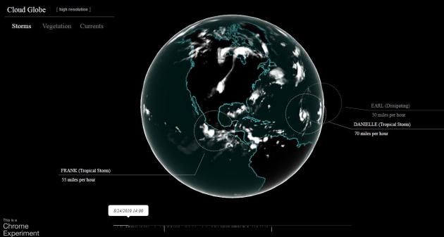
Cloud Globe. This is one of the better
visualizations I've seen in recent years - 3 years worth of weather
patterns condensed into about 10 minutes of animation, courtesy of
chromeexperiments.com. Every tropical storm and hurricane in the Atlantic, Caribbean and eastern Pacific is labeled and tracked over time. Very cool.
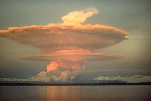
"Overshooting Top". This is one of many
(take-your-breath-away) photos you can graze at The Cloud Appreciation
Society, a remarkable example of a violent thunderstorm updraft that
broke thru the tropopause into the stratosphere, an "overshooting top".
Probably a good idea to give it a wide berth.
Apple TV And Airplay Fuel Rise Of Dual-Screen Apps.
Not sure how you consume media, but it's rare that I fixate on the TV
screen anymore. It's on in the background, sort of video/audio Muzak,
while I pound away on my laptop, check my iPad, check apps and texts on
my smartphone. My wife is doing the same digital juggling. We just grunt
at each other every now and then. Lovely, this new, multi-tasking,
perpetually distracted new digital world.
Mashable has details on a new, emerging trend: "
Dual-screen
apps are a new phenomena, enabled by the advent of wireless
technologies that allow for effortless pairing of a PC, tablet or
smartphone with a TV. They are changing how people are interacting and
“consuming” content within apps. For developers this creates many new
opportunities to provide better experiences for their users, but it
requires thinking about dual-screen setups from the start as well as new
tools. The opportunity for dual-screen apps is huge. And it’s more
than just watching a video or playing a game: Dual-screen apps have the
potential to transform the office meeting room, the classroom, the
retail store, the hospital, and really any other context where people
are interacting around content and information and where that
information would benefit from rendering and display on a large screen
such as a TV monitor..."
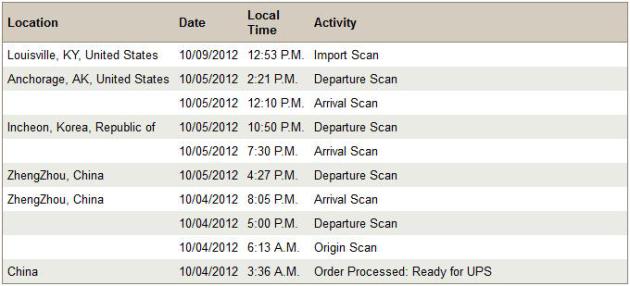
My New iPhone 5's Amazing Global Journey. I'm a
little freaked out about the mapping (bug?) - but still looking forward
to a slimmer, wider, faster iPhone. Yes, this should complete me, make
me a better person. At least for the next 6 months. Uh huh. The screen
shot above is from UPS, showing the long, strange journey from
ZhengZhou, China to Korea to Anchorage to Louisville (?) and then on to
the Twin Cities. I should get frequent flier miles.
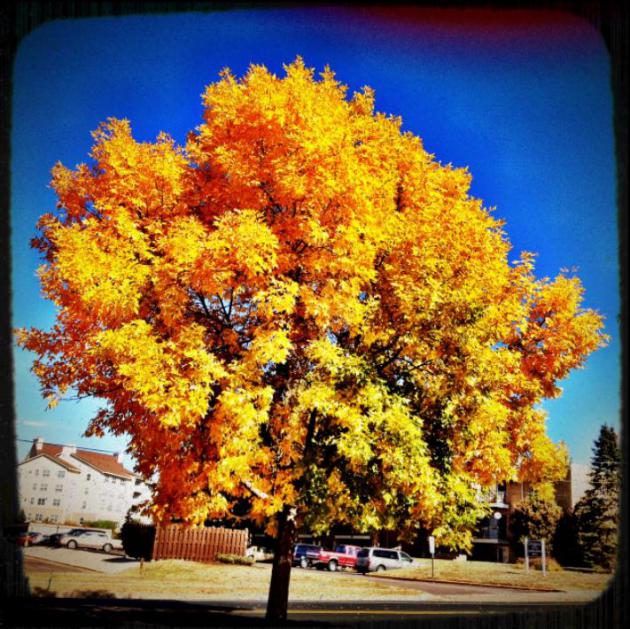
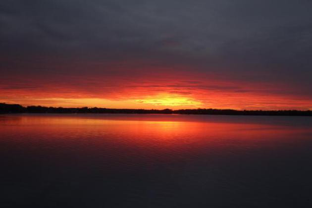 Technicolor Sunset.
 Did you see the sunset yesterday evening? I snapped this photo around 6:45 pm, the sky the color of molten lead. Nice.
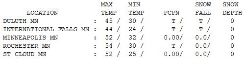
A Chilling Breeze. No sign of Indian Summer out
there, not yet, anyway. With a mix of clouds and sun highs were a good
10 degrees cooler than average on Wednesday; ranging from a brisk 44 at
International Falls (with a trace of rain and snow) to 52 St. Cloud and
the Twin Cities to 58 at Redwood Falls.
Paul's Conservation Minnesota Outlook for the Twin Cities and Greater Minnesota:
TODAY: Cool clipper. Mix of clouds & sun. Winds: NW 10-20. High: near 50
THURSDAY NIGHT: Clear and chilly - small chance of spying the Northern Lights? Low: 28
FRIDAY: Early freeze. Sunny, becoming breezy. Winds: SE 15. High: 53
SATURDAY: Steady, heavy rain possible. Low: 48. High: 58
SATURDAY NIGHT: Periods of rain, dense fog in the area. Low: 50
SUNDAY: Morning fog and clouds. Becoming partly sunny, the nicer outdoor day. High: 59
MONDAY: Early sprinkle, then clearing skies. Low: 45. High: near 60
TUESDAY: Indian Summer! Warm breeze, fading sunshine. Low: 48. High: near 70
WEDNESDAY: Patchy clouds, late showers. Low: 50. High: 61
Threat...And Opportunity
“I’m proud of having been one of the first to
recognize that States and the Federal Government have a duty to protect
our natural resources from the damaging effects of pollution that can
accompany industrial development." Al Gore? Barack Obama? No. Ronald
Reagan.
When people ask why I'm so vocal &
persistent about reporting climate science I tell them it's the greatest
environmental challenge we've ever faced. And if you care about your
kids and grandkids you should take it seriously, too.
It's not all gloom & doom - this is a chance
to reinvent and retool America, and wean ourselves off foreign oil. In a
speech to the Minneapolis Federal Reserve today I'll tell them
"mitigating climate change will require a level of sustained innovation
and American reinvention that will propel the USA to a new competitive paradigm."
American Exceptionalism? This is our Energy Moonshot. It's ours to lose.
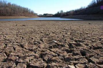
Saturday may be the wettest day since mid-August
(.50 to 1" possible), putting a minor dent in our deepening drought.
The sun peeks out by Sunday afternoon, the better (soggy) leaf-raking
day of the weekend.
Next week we'll stash jackets into cold storage;
Indian Summer returns with a run of 60s. Soak it up. Chilly weather
returns late October.
Ronald Reagan, The Environmentalist. Quote above courtesy of
climateconservative.org.
Climate Stories....
 Global Warming May Shift Summer Weather Patterns
. Here's more on the recent Nature research paper, courtesy of Andrew Freedman at
Climate Central:
"
By altering the heat balance between land and sea, manmade global
warming may be altering summer weather patterns in the Northern
Hemisphere, a new study found. The study, published on Sept. 30 in Nature Geoscience,
shows that the sprawling high pressure areas that set up shop over the
Western North Atlantic and North Pacific Oceans during the summer months
have become larger and stronger during the past 40 years, and these
trends are likely to continue during the next several decades as
temperatures increase. These changing weather patterns could have far-reaching impacts, from
redirecting powerful hurricanes toward the East Coast, to making the
Southeast and Central states see-saw more frequently between extremely
hot and dry summers and cooler, wetter summers. In addition, a shift in
the strength and shape of the North Pacific subtropical high could
affect the South Asian Monsoon, which is already being altered by
warming and increased regional pollution. .."
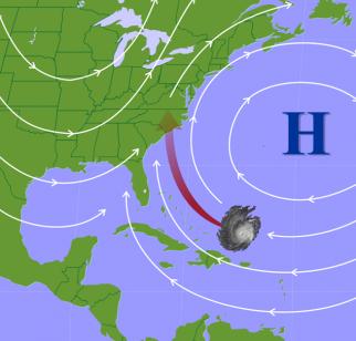
Graphic credit above:
"The Bermuda High helps steer tropical storms and hurricanes." Credit: Penn State.
Climate Change To Lengthen Growing Season. Here's a snippet of a story at
physorg.com: "
Scientists
expect the global mean temperature to rise in the future. One
consequence is that by the end of this century, Norwegian farmers could
be growing their crops for up to two months longer. In areas of higher
elevation, in fact, the difference could turn out to be three months.
The growing season is defined as the number of days with an average
temperature of at least 5 C."
Scientists expect the
global mean temperature to rise in the future. One consequence is that
by the end of this century, Norwegian farmers could be growing their
crops for up to two months longer. In areas of higher elevation, in
fact, the difference could turn out to be three months. The growing
season is defined as the number of days with an average temperature of
at least 5°C. Exploiting a warmer climate A warmer climate would open
up several exciting opportunities for Norwegian agriculture.
Thermophilic (warm-weather) crops could be cultivated farther north,
and multiple harvests may be possible each summer, as is common at more
southerly latitudes.
Read more at:
http://phys.org/news/2012-10-climate-lengthen-season.html#jCp. Here's an excerpt of an encouraging story from
Live Science: "
The
majority of Americans think global warming is not only affecting
weather but is also worsening extreme weather events, including
record-high summer temperatures and the Midwest drought, a new survey
released today (Oct. 9) finds. Between Aug. 31 and September, more than
1,000 participants ages 18 and over answered survey questions about
their beliefs on global warming and its link to weather events. The results were weighted to give nationally representative numbers..."
Photo credit above: "
A survey released Oct. 9, 2012, finds
the majority of Americans think global warming worsened extreme weather
events, including the U.S. drought and record-high summer temperatures." Credit: NOAA.
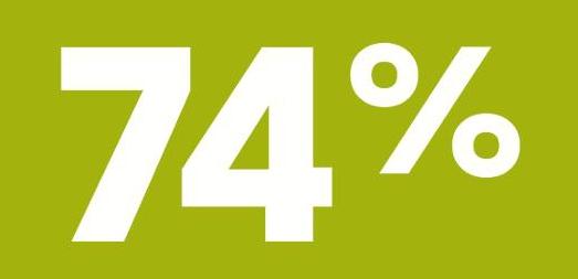
Sustainability Indicator: 74% Global Warming Realists. Another perspective from
Bloomberg.com; here's the introduction to the story: "
Today's sustainability indicator, 74 percent, is the proportion of Americans who acknowledge that "global warming is affecting weather in the United States." That's 5 percentage points higher than a similar survey conducted in March.
Recent indicators:
- 5.8 percent: U.S. electricity needs met by non-hydro renewable energy.
- 3.1 percent: electricity produced by non-hydro renewables in 2008.
- 213: current measure of the UN's World Food Price Index.
- 210: the price threshold associated with a sharp rise in social unrest and food riots.
- 50 percent: world transport fuels replaceable by converting 17.5% of farm waste to biofuel.
- 1.32 million square miles: Current Arctic sea ice, the least in 33 years of satellite records...."
 Experts: Global Warming Means More Antarctic Ice
. Here's a clip from an article at
AP: "
WASHINGTON (AP) — The ice goes on seemingly forever in a white
pancake-flat landscape, stretching farther than ever before. And yet in
this confounding region of the world, that spreading ice may be a
cockeyed signal of man-made climate change, scientists say. This is Antarctica, the polar opposite of the Arctic. While
the North Pole has been losing sea ice over the years, the water
nearest the South Pole has been gaining it. Antarctic sea ice hit a
record 7.51 million square miles in September. That happened just days
after reports of the biggest loss of Arctic sea ice on record..."
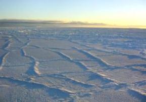
Photo credit above: "
This handout photo provided by NSIDC, University of Colorado, taken in
Oct. 2003, shows the Antarctic sunlight illuminating the surface of the
sea ice, intensifying the effect of the fracture lines. The ice goes on
seemingly forever in a white pancake-flat landscape, stretching so far
it just set a record. And yet in this confounding region of the world,
that spreading ice may be a cock-eyed signal of man-made climate change,
scientists say." (AP Photo/NSIDC, University of Colorado)
No, You're Not Entitled To Your Opinion. Not all opinions are created equal, at least when it comes to science. Details at
The Conversation; here's an excerpt: "
Every
year, I try to do at least two things with my students at least once.
First, I make a point of addressing them as “philosophers” – a bit
cheesy, but hopefully it encourages active learning.
Secondly, I say something like this: “I’m sure you’ve heard the
expression ‘everyone is entitled to their opinion.’ Perhaps you’ve even
said it yourself, maybe to head off an argument or bring one to a
close. Well, as soon as you walk into this room, it’s no longer true.
You are not entitled to your opinion. You are only entitled to what you
can argue for.” A bit harsh? Perhaps, but philosophy teachers owe it
to our students to teach them how to construct and defend an argument –
and to recognize when a belief has become indefensible...."
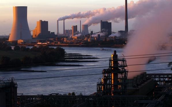
Mapping Global Warming: Scientists Visualize Carbon Emissions in Phoenix, Los Angeles and Indianapolis. Street-specific, neighborhood-level mapping of greenhouse gas emissions?
Latinos Post has the story; here's an excerpt: "
Hestia,
a greenhouse gas mapping initiative backed by Arizona State University
(ASU), sets out to "simulate and visualize the metabolism of
greenhouse gas emitting activity down to the building and street level,"
according to the program's official site
The researchers behind Hestia strive to map each of the major cities
in America, providing government officials with a powerful tool to
reduce carbon emissions. The program is currently mapping Indianapolis,
Indiana, Los Angeles, California, and Phoenix, Arizona..."
Photo credit above: Reuters. "
Hestia is currently working on maps for Indianapolis, Indiana, Los Angeles, California, and Phoenix, Arizona."


No comments:
Post a Comment