51 F. high in the Twin Cities Tuesday.
61 F. average high for October 9.
83 F. high on October 9, 2011.
.03" rain fell yesterday in the Twin Cities.
Freeze likely Friday morning.
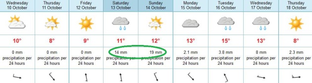
1"+ rains possible close to home Saturday into Sunday.
60-degree highs possible early next week.
3.8 F. The national temperature of 59.8 F. (January
thru September, 2012) was 3.8 F. above the 20th century average, and
1.2 F. above the previous record warm January - September of 2006.
Source: NOAA NCDC. Details below.
Driest year since 1988. The first 9 months of 2012 were the driest in 24 years. Source: NCDC.
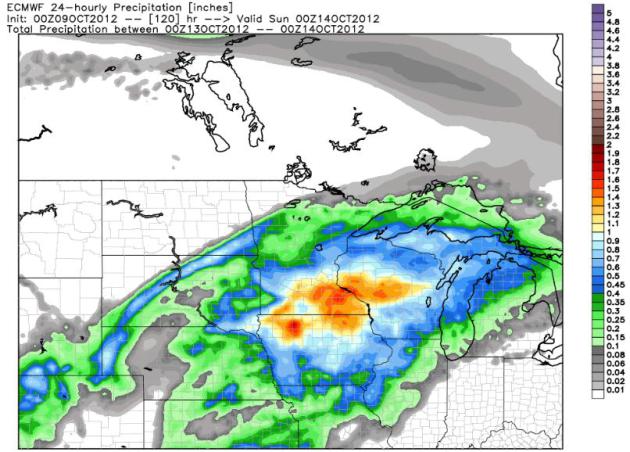
Welcome Rain - Lousy Timing. I'm not about to
complain about rain, not now, with so much of Minnesota in severe to
extreme drought. The ECMWF (European) model shows rain Saturday spilling
over into part of Sunday, especially eastern Minnesota and Wisconsin.
U.S. models are suggesting 60s Saturday. I'm not so sure. The ECMWF has
been fairly consistent with temperatures in the low to mid 50s. I doubt
we'll have severe storms close to MSP this weekend, although a few
strong storms are possible over Iowa and Illinois. We should warm close
to 60 early next week.
Severe risk Saturday? Right now I don't see it for most of Minnesota, the threat greatest from Missouri into Iowa. Details below.
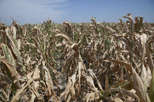
53% "
As of last week, more than 53 percent of
the corn had been harvested, the earliest that has happened in at least
50 years -- and maybe ever. "We're about three weeks ahead of normal,''
said Doug Hartwig, director of the U.S. Department of Agriculture's
National Agricultural Statistics Service in St. Paul. "It's been pretty
amazing.'' - details in
The Star Tribune. Photo: Nati Harnik, AP.
Promising Trends. It will take 4-8 of these storms
to help us pull out of the drought, but we really need (soaking/steady)
rains over the next 30 days, before the ground freezes up. All the
models pull enough Gulf moisture north for an inch of rain. I hope the
models are right.
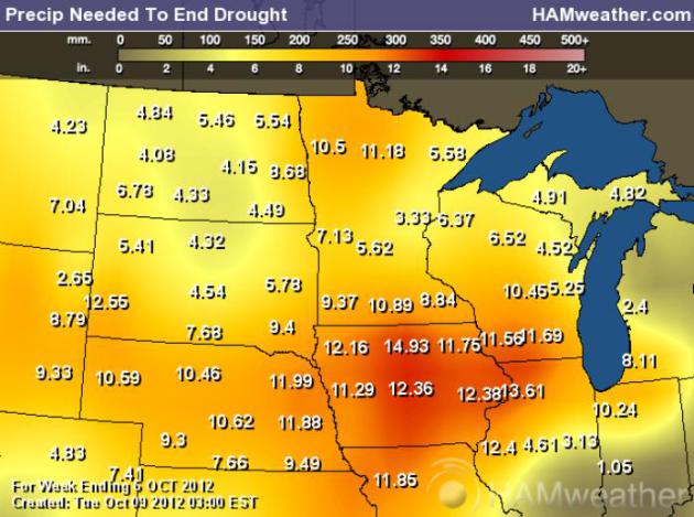
Rain Needed To End The Drought. The Palmer Index
tells the tale, a fairly tall order, meteorologically speaking. Anywhere
from 5 to 11" of rain is needed to eliminate the drought, closer to 3"
near Sandstone and Hinckley. Map above: NOAA, USDA and
Ham Weather.
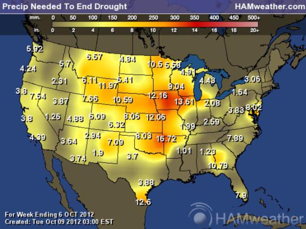
National Palmer Index. At a glance you can see which
parts of the USA are suffering through major to extreme drought. Over a
foot of precipitation is needed from Iowa and northern Illinois to
Omaha and Kansas City, closer to 17" for Texarkana. Map above: NOAA,
USDA and
Ham Weather.
Weather Highlights:
* The average contiguous U.S. temperature during September was 67 F,
1.4 F above the 20th century average, tying September 1980 as the 23rd
warmest such month on record. September 2012 marks the 16th consecutive
month with above-average temperatures for the Lower 48.
* According to the October 2, 2012 U.S. Drought Monitor, 64.6 % of
the contiguous U.S. was experiencing moderate-to-exceptional drought,
slightly larger than the extent of drought at the end of August. The
percent area of the nation experiencing exceptional drought, the worst
category of drought, remained nearly constant at about 6%. Exceptional
drought conditions improved across the Lower Mississippi Valley and Ohio
Valley, while drought conditions deteroriated across the Central and
Northern Plains.
*
The January - September period was the warmest first 9 months of any year on record for the contiguous USA.
The national temperature of 59.8 F. was 3.8 F. above the 20th century
average, and 1.2 F. above the previous record warm January - September
of 2006. During the 9 month period, 46 states had temperatures among
their ten warmest, with 25 states being record warm. Only Washington had
statewide temperatures near average for the period.
*
January - September 2012 was the 11th driest such period on record for the contiguous U.S.
with a precipitation total 1.98" below the average of 22.67". The
central portion of the country, from the Ohio Valley to the Rocky
Mountains, was drier than average. Wetter-than-average conditions were
observed along the Gulf Coast and in the Pacific Northwest.
"
This year, the harvest is way earlier than usual, which will tip the advantage to hunters.'' - more on Saturday's Minnesota Pheasant Opener from the Star Tribune below. Photo:
gameandfishingmag.com.
"
In hotter weather, the pitcher on the team whose player was hit is more likely to retaliate by hitting a batter on purpose."
- from a Huffington Post story on how climate change is changing
behavior on the field, and how Major League Baseball is becoming a
national leader in energy efficiency.
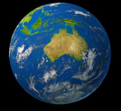
5,000 scientific papers every year substantiating
the connection between human activity and climate change. - from a
"Climate of Change" post by Doug Craig, details and links below. Image
above:
Colorado State University.
"
It was always the case that extreme weather was going to be the
way that most people were going to experience climate change
directly—that seemed clear to me from all my research. Extreme weather
is very random, but it is on top of a climate signal that continues
to grow. So over time, you get more and more extreme events that are
way above the natural variation."
"
Indeed, Romm has called Obama's failure to speak out about global warming, loudly and often, his "biggest communications mistake." Now, a raft of new polls are showing that this issue has the potential to move independent and swing voters.." - both excerpts above from a story at Mother Jones; details and links below.
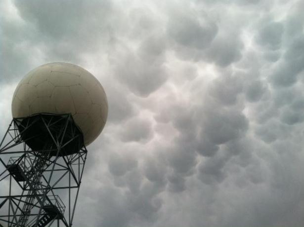
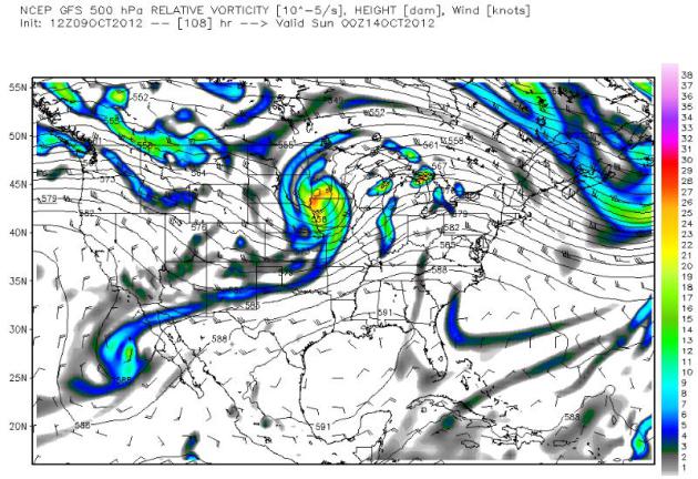
Saturday Severe Risk.
SPC
has an "enhanced" risk of severe storms over much of the Upper Midwest,
from Kansas City and Des Moines to Tomah, Wisconsin and parts of
southern Minnesota. The reason? Southern moisture surging north, coupled
with wind shear and instability aloft. A major tornado outbreak?
Doubtful, but a few storms may spark hail and damaging straight-line
winds, especially south/east of Minnesota.
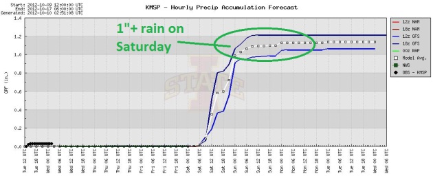
Saturday Soaker? The ECMWF (European) model is
showing some 1 to 1.5" rainfall amounts from the Twin Cities into
northern Iowa Saturday. Let's hope the models are right.
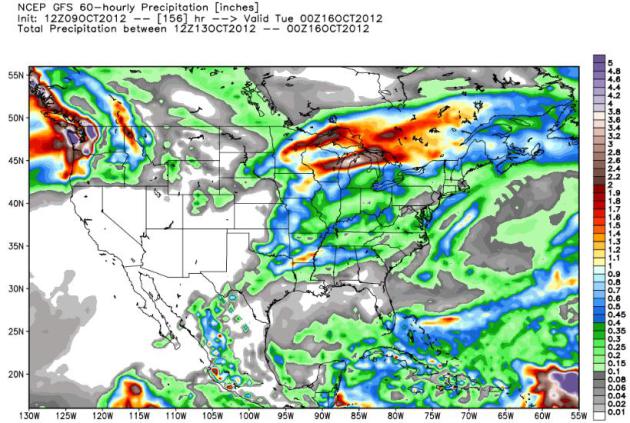
Continuity. The GFS is also showing significant
rainfall amounts by midnight Saturday, close to 1" for the MSP metro, as
much as 1.5 to 2" farther north, from near Brainerd to Duluth, a second
streak of moderate to heavy rain over central Wisconsin.
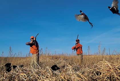
Early Harvest Signals Excellent Pheasant Hunting.
Low clouds and rain Saturday may help to bring those pheasants closer to
the ground for the Pheasant Hunting Firearm Opener. Doug Smith has more
details at
The Star Tribune; here's an excerpt: "
When
Minnesota pheasant hunters begin the 2012 season on Saturday, they will
see one of the most unusual openers in history. Pushed by an early
spring and drought, harvest of virtually all the state's crops likely
will be completed, leaving ringnecks more vulnerable to hunters and
their dogs. And with the pheasant population up 68 percent from last
year, that could mean excellent early-season hunting."
Photo above courtesy of meteorologist Tony Barlow at
weathertheoutdoors.com.
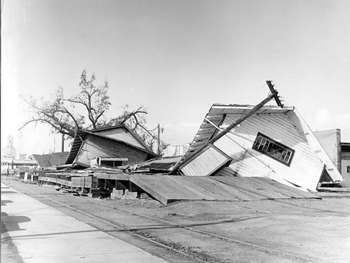
50 Years Later, Memories Of The Pacific Northwest's "Storm Of The Century' Hold Strong.
Here's a harrowing account of a storm that still haunts some residents
of the Northwestern USA, as described by Randi Bjornstad at the
Register-Guard: "
As
young as a year then or approaching a century now, most people who
lived in Oregon 50 years ago this week seem to have a personal tale to
tell about the Columbus Day Storm of Oct. 12, 1962. They describe where
they were and how they felt, in much the same way that most people
throughout the nation vividly remember one year, one month and 10 days
later, when President John F. Kennedy was assassinated in Dallas. Among
those in their 70s or older, the even more inescapable memory is the
shock of the news on Dec. 7, 1941, that Pearl Harbor had been bombed by
Japan’s air forces, catapulting the country into the horrors and
triumphs of World War II. The storm itself was a losing battle of sorts
against Mother Nature as men, women and even children fought their way
through the gale home to their families, battened down their personal
hatches as best they could and then watched breathlessly and helplessly
as the ferocious wind toppled trees and sent roofs, signs, sheets of
plywood, garbage cans — and even lightweight people — flying through
the air....
Photo courtesy of OSU, Oregon State University, which has another perspective of the historic, 1962 super-storm
here.
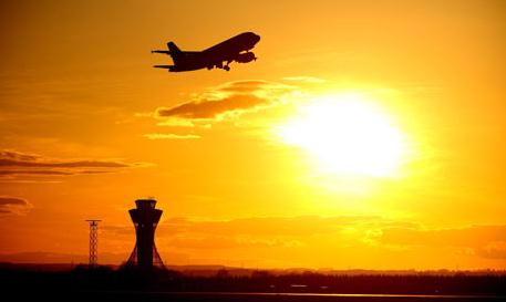
Pilots Get New Tool To Avoid Bumpy Flights. All
pilots are in search of smooth air, to keep the customers in the back as
contented as possible. New tools are being tested to increase the odds
of avoiding the big jolts that can turn a typical flight into a (bad)
lifelong memory. AP and
WashingtonExaminer.com have more details: "
JUNEAU,
Alaska (AP) — Sam Gottstein has had some memorable flights, but
nothing like the nail-biter coming into Alaska's capital city earlier
this year. The flight between Anchorage and Juneau was uneventful until
the final descent, he said, when visibility was cut to almost nothing
and the plane shook. "There was definitely a collective sigh of relief
after we successfully landed, and I feel as if a number of the
passengers felt like we bonded together over it," Gottstein said. It is
experiences such as this that aviation officials hope to avoid, or at
least limit, with a new system that alerts pilots to pockets of
turbulence and highlights corridors of smoother air."
Photo: Owen Humphreys, AP.
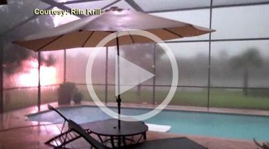
Florida Woman Photographs "Fireball" In Thunderstorm.
ABC News has the story, and video clip; here's an excerpt: "
Rita
Krill, 53, of Naples, Fla., got a little more than she bargained for
while shooting a severe thunderstorm in her backyard Oct. 5. “It was
about 100 feet from my yard,” Krill said. “I was out there videoing it.
My puppy was out there. She usually doesn’t flinch too much at storms.
She’s used to it. And then, boom, the lighting struck and you could
obviously hear my reaction.” Krill can’t believe she captured the
lightning striking the up-lighting in her next door neighbor’s yard on
camera, which blew out the light and caused large electrical sparks...."
Video credit above: Rita Krill.
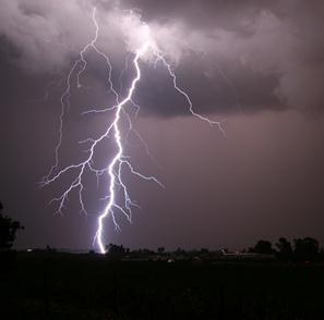
Lightning Deaths On The Decline In U.S. Here's an excerpt from a fact-filled story at
Huffington Post: "...
So why are lightning-related fatalities falling off? The population has been increasing, which would seem to make for more lightning targets
and more fatal run-ins. Is lightning striking less frequently?
Lightning expert Douglas Jordan says no. "Statistically I don't think
anything's really changed, lightning flash
density or anything like that," Jordan, director of operations at the
International Center for Lightning Research and Testing, a joint
project of the University of Florida and Camp Blanding Florida Army
National Guard Base, told Life's Little Mysteries. "My guess is that it
probably has more to do with education than anything else. I think a
lot of people are getting the word out [on lightning safety]." Lightning photo above: NOAA.
Disaster Tourism: How Bus Trips To The Scene Of Hurricane Katrina Make A Profit From Loss. Ghoulish? Absolutely, but good taste has rarely gotten in the way of making money, as described in the U.K.
Independent; here's an excerpt: "
Planning your next holiday? If it’s a cultural experience you’re after, forget Athens or Istanbul, Grey Line Tours
suggests a visit to the scene of Hurricane Katrina “the most
devastating natural disaster on American soil!” In between choosing
souvenirs, you can take a quick whizz through the streets of the most
devastated areas of New Orleans and watch surviving citizens pick their
way through the rubble from the comfort of your air conditioned bus. I’m exaggerating, slightly, but as news last week emerged that New Orleans’ residents and city officials were hitting back at tour operators
who have, since shortly after Hurricane Katrina, carried out tours of
the worst hit areas of the city, it elicited what I imagine to be a
pretty common gut response. Tourism that profits from the struggle and
loss of others seems intuitively distasteful, not least because the tour
buses have been criticized for blocking roads for the residents..." Photo: The Independent.
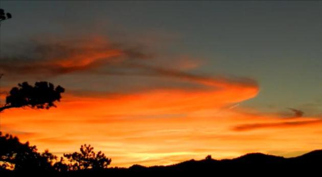
"Grotesquely Beautiful" Psychedelic Neon Sunset! Yes, the sky over Loveland, Colorado really was this shade of neon orange. The result of jet contrails? Not sure, but the
YouTube clip is pretty amazing.
iPad Mini Images Leaked. This looks like the real deal. An iPad you can slip in your sport coat? Looks like it. Here's a clip from
iPhone Informer: "
Ahead
of the long rumored announcement of the iPad Mini this week, brand new
images of the device has found its way online thanks to an anonymous
tipster from the assembly room floor. The images found their way through
all the typical channels until it ended up in Sonny Dickson’s possession, which was immediately posted online for everyone to see..."
Overworked, Overwhelmed, Overscheduled? Work More.
All of us are juggling. Technology was supposed to set us free - instead
it's given us the tools to do 4 jobs (simultaneously), and feel like we
can never get off the digital treadmill. Here's an excerpt of an Op Ed
that caught my eye at
Wired.com: "
You
are overwhelmed, overscheduled, and dejected, because you keep trying
to have it all—or at least most of it. You want a fulfilling job and
personal life, and it’s not working. The way out? Work more. Hate to
break it to you, but career and home aren’t the only poles. There is
another: all those beautiful, disregarded side projects. Does that make
you want to pitch your desk lamp straight into my face? Fair. But that
itchy desire only means I’m right. Obviously, neglecting your family
and home eventually gets them both confiscated by people with
clipboards and badges. But if you want to be a maker of things—or at
minimum avoid a quietly desperate life in front of the television—you
have a responsibility to head down to the workshop. Even the coolest
jobs get stultifying with repetition, and the only way to break that
cycle is to bring another job into the mix..."
The "Fitwet" Jetbike Combines An Excercise Bike And A Hot Tub.
This is just what I need, the ultimate mash-up. No, when I soak in a
hot tub the last thing I want to do is peddle like a maniac, but just in
case you do - here's more information from
gizmag.com: "
Relaxation
and vigorous exercise rarely coexist, but the FitWet Jet Bike brings
them together – sort of. The contraption is a unique piece of exercise
equipment that combines a stationary (underwater) bike with a personal
jetted tub. Exercise just got a little more attractive."
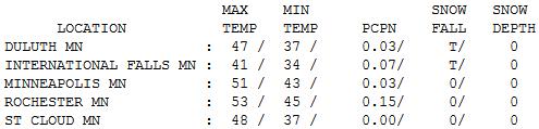
Soggy & Blustery. After a showery start, skies
tried to clear, but instability stratocumulus clouds quickly filled into
a brisk, northwest flow. Rochester picked up .15" rain Tuesday morning
as the clipper sailed across the state. Daytime highs ranged from 41 at
International Falls to 43 Alexandria, 48 St. Cloud, 51 Twin Cities and
53 at Rochester.
Paul's Conservation Minnesota Outlook for the Twin Cities and all of Minnesota:
TODAY: Blue sky, a few popcorn cumulus. Winds: NW 10-15. High: 52
WEDNESDAY NIGHT: Mostly clear, not as chilly. Low: 40
THURSDAY: Another clipper. Clouds & sun, cool breeze. High: 52
FRIDAY: Early freeze. Sunny, winds increase. Low: 29. High: 54
SATURDAY: Steady rain likely, the most in nearly 2 months? Low: 44. High: 57
SUNDAY: Showers taper; PM sun. Milder. Low: 48. High: 62
MONDAY: Alberta Clipper. Patchy clouds, a few sprinkles. Low: 41. High: 58
TUESDAY: A few showers return. Low: 45. High: near 60
Change in the Weather?
Our last significant rainfall in the metro? Way
back on August 15, when .73 inches fell. Since then: dribs and drabs of
moisture. Yes, our drought is getting worse.
Based on NOAA and USDA Palmer Index data (check
the blog) most of Minnesota needs 5 to 11 inches of rain to end the
drought. That won't happen anytime soon, but I'm detecting subtle shifts
in the pattern that may help to pump Gulf moisture northward with
greater frequency into November. A dry, "zonal", west-to-east steering
flow aloft shows signs of buckling; high amplitude dips & bulges in
the jet stream, increasing the chance of beefier storms reaching our
lofty latitude.
Both the ECMWF and GFS models print out over 1
inch of rain Saturday and Sunday; close to 2 inches Brainerd to Duluth.
That's encouraging.
Pheasant hunters may have ideal conditions Saturday.
It'll feel more like Halloween out there the
rest of this week; another hard freeze Friday. Time to take out the dock
and winterize your yard. Ugh.
If I don't rake - will the leaves in my yard wind up in Madison? A worthy experiment.
We may hit 60 early next week, but long-range models show a cold, blustery end to October. Flurries by Halloween?
Could be.
Climate Stories...
Major League Baseball Copes With Climate Change. Here's an excerpt of a fascinating story from the Union of Concerned Scientists at
Huffington Post: "...
In April 2011, Larrick and three of his colleagues at Duke University's Fuqua School of Business published a paper
in the journal Psychological Science that analyzed data from more than
57,000 baseball games from 1952 to 2009, which included 4.5 million at
bats. Of the approximately 190,000 at bats that happen every season,
roughly 1,550 result in a pitcher hitting a batter. After factoring out
such variables as wild pitches and fatigue, they superimposed game
stats over weather data and found that batters had a 27 percent chance
of being hit by a retaliatory pitch when the temperature topped 90
degrees, but only a 22 percent chance when temperatures dipped into the
50s..."
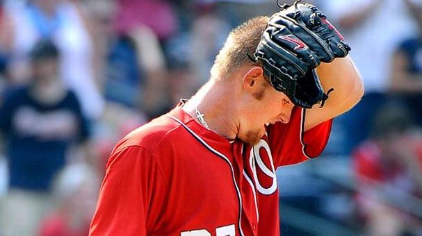
Photo credit above: "
Temperatures approaching 120 degrees
on the field in Atlanta on June 30 sent Washington Nationals power
pitcher Stephen Strasburg to the showers after only three innings." (David Tulis/AP)
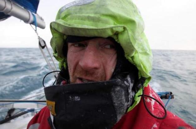
Norwegian Brings Arctic Circle Climate Change To South Dakota. Here's another must-read story, an excerpt from an article at Sioux Fall's
Argus Leader: "...
The
impetus for this trip was simple, Thorleifsson said: “I wanted to see
the world (as it was) before the Arctic melted. I wanted to tell my
kids about it.”Indeed, Thorleifsson supplemented the scientific case for a changing climate with firsthand observation of the melting ice cap.“We
might argue about why it’s happening,” he said. “But there’s no doubt
it’s happening. ... The question is, do we have the mission right, as
human beings?”
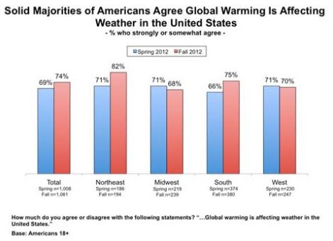
Polls Show Jump In U.S. Climate Awareness. Extreme
weather is doing what legitimate, peer-reviewed climate science couldn't
- convince a significant majority of Americans that our climate is, in
fact, changing - becoming more extreme with time. Here's an excerpt from
Climate Denial Crock Of The Week: "
Nothing
like getting slammed with a 2 x 4 to focus the mind. As I promised,
here’s new polling data shows that weather extremes are finally
starting to be recognized as symptoms of climate change. At last
spring’s Heartland Institute Denia-Palooza, a high profile disinformer
told me in a candid moment that one of his biggest concerns was extreme
weather events, and their power to change people’s minds. This is
indeed what we are seeing – and with this recently passed historic drop
in arctic ice cover, they are not going away any time soon. Arctic
expert Jennifer Francis told me in a recent Skype conversation that
given the projected effects of newly open water on the jet stream, we
should, indeed, expect “very interesting” weather in coming months..."
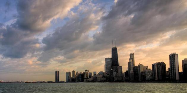
How To Build A Cooler City. Here's an interesting article at
PBS - an excerpt: "..."
Climate
change basically exacerbates the effect at night," Fernando said. As
the global temperature increases, a city's developed areas will retain
even more nighttime heat than other areas. To battle the heat, city
officials have undertaken an ambitious $7 billion plan to build a "new
Chicago," said Karen Weigert, the city's chief sustainability officer.
That means renovating citywide infrastructure from sidewalk to
rooftop. Central to the city's plan is adding green space and vegetation
wherever they can, which has a natural cooling effect Chicago's City
Hall, for example, contains a spectacular rooftop garden. From native
woodland grasses to sunflowers and asters, plants arranged in radiating
bands of color bloom throughout the seasons in a sunburst pattern. The
roof, 12 stories high, contains 23,000 square feet of more than 100
plant species..."
Who Are The Climate Change Deniers? Here's a snippet of an article written by Doug Craig at "Climate of Change", which can be found at redding.com: "
These prominent deniers deny because it is good for their personal and professional bottom lines. ExxonMobil, for example, financed "the
most sophisticated and most successful disinformation campaign since
the tobacco industry misled the public about the scientific evidence
linking smoking to lung cancer and heart disease" in a concerted "effort to deceive the public about the reality of global warming."
And who did they give millions of dollars to promote their climate
change denying agenda? Try over 40 different conservative organizations
like the American Enterprise Institute (AEI), American Legislative Exchange Council (ALEC), Cato Institute,Competitive Enterprise Institute (CEI), George C. Marshall Institute,Heartland Institute,Heritage Foundation and Tech Central Station. In turn, these organizations funded a small handful of scientific spokespersons such as Sallie Baliunas,Robert C. Balling, Jr.,John Christy,Sherwood Idso,Richard Lindzen,Patrick J. Michaels,Fredrick Seitz, S. Fred Singer, and Willie Soon."
Why Aren't Politicians Listening To This Guy On Climate? Mother Jones has the story; here's an excerpt: "
Joe Romm has been called "America's fiercest climate blogger."
And as a senior fellow at the Center for American Progress, a former
Clinton administration official on clean energy, and an MIT trained
physicist, the subjects he covers are vast—ranging from energy policy to
the role of rhetoric in communications, as discussed in his new book Language Intelligence. But there's been a recurrent theme over the years at Joe Romm's popular blog Climate Progress—the
argument that political leaders, and perhaps most prominently
President Obama, need to step up and explain to the public why global
warming is such a dramatic threat to our livelihoods and future."
Photo: climatechangedispatch.com.
Sea Level Rise Will Make Several Islands Uninhabitable Within A Decade. The story from
Business Insider;
here's an excerpt: "Sea level rise and extreme weather is going to get
so bad, that some island nations may need to evacuate within a decade,
Micheal Mann, a lead climate scientist,
told the Guardian at the
SXSW Eco
conference. Mann is the director of the Earth System Science Center at
Penn State. He suggests that new data indicates that our models of
climate change are incorrect and have been underestimating the rate at
which the Greenland and Antarctic Ice sheets are melting..."
Sub-Tropical Dry Zone Is Expanding South. Here's evidence of a warming atmosphere; details from
Red Orbit: "
New
research reported in the journal Scientific Reports claims that the
southern hemisphere is becoming drier. The researchers wrote that a
decline in April-May rainfall over southeast Australia is associated
with a southward expansion of the subtropical dry-zone..."
Photo credit above:
Lightspring / Shutterstock


No comments:
Post a Comment