59 F. high in the Twin Cities Sunday.
59 F. average high for October 14.
57 F. high on October 14, 2011.
60+ today, 70+ tomorrow.
Rain likely Wednesday and Thursday. Wet snowflakes may mix in by Thursday night.
70+ temperatures possible early next week.
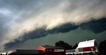
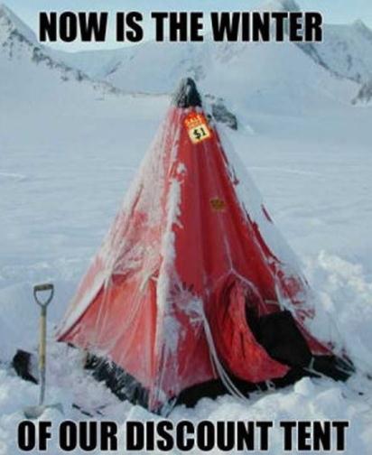
 "I Double-Dare You To Jump, Felix!"
 Details on the jump, the LEAP, heard around the world, a swan-dive from the edge of space, 24 miles above the ground, below.
3rd warmest summer on record for the USA. Source: NOAA NCDC.
"...
We believe that God is calling us to take action towards
overcoming the climate crisis. For us, this means living as good
stewards of God’s creation, advocating on behalf of the poor and
marginalized, supporting our faith leaders when they stand up for
climate action, holding our political leaders accountable for
responsible climate policies, and mobilizing our generation and the
larger church community to join in." - part of a Call to Action from the web site of
Young Evangelicals for Climate Action. Details below. Image:
sharefaith.com.
"...
Around the world, "the incidence of drought is consistent
with what the climate models are predicting," said John Seinfeld, an
atmospheric researcher at Caltech. "It certainly doesn't appear to be
out of line to conclude that this last summer could be statistically
attributed to global warming." - from a Los Angeles Times story, full details below.
"...
One of the problems with climate change has always been that
it was distant and remote, “but this year weather made it immediate.”
As extreme weather ravaged the majority of the United States this
summer, people who once doubted global warming are now seeing first
hand the wrath climate change can impose on their daily lives and their
wallets..." - from a story at Climate Science Watch, links below.
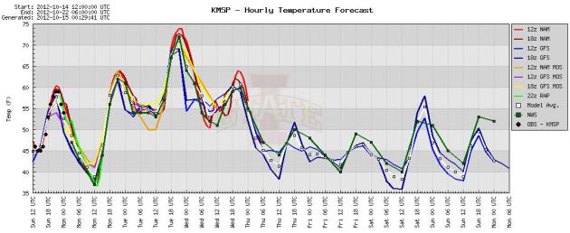 35 Degree Temperature Tumble Later This Week
.
After topping 60 today, and 70 Tuesday, a surge of Canadian air will
beat down the mercury in your backyard thermometer - "highs" probably
stuck in the 40s by Thursday, when rain could even mix with a little wet
snow. With surface temperatures above freezing I don't expect any
accumulation right now, at least not in or near the MSP metro area.
Graph above: Iowa State.
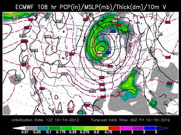
 Atmospheric Yo Yo
.
The forecast calls for mid-September, then early November, followed by
another round of mid-September. Makes perfect sense to me! Wednesday and
Thursday appear to be the two wettest days, with some .5"+ rainfall
amounts possible midweek, enough cold air aloft for a few snowflakes
Thursday night? Skies clear next weekend with a run of 70+ temperatures
possible early next week, based on ECMWF guidance above.
84-Hour Outlook. A cool front nudges "Rafael" out to
sea, no threat to the east coast of the USA. A couple of mild days
early in the week give way to a blast of colder air by midweek, sparking
rain Wednesday and Thursday across the Upper Midwest and Great Lakes.
Meanwhile, Tropical Storm Paul in the eastern Pacific brushes Cabo San
Lucas with heavy rain, expected to weaken as it pushes north toward Baja
Mexico. Loop above courtesy of NOAA.
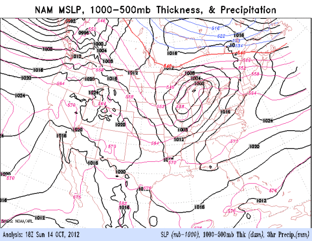
"Cut Off Low". The ECMWF solution (valid Thursday
evening at 7 pm) shows a deep storm in the upper atmosphere, a cold
whirlpool aloft, temporarily stalled over the Upper Midwest. A steep
lapse rate coupled with moisture wrapping all the way around this
sprawling low will spark a cold rain Wednesday and Thursday. Map above:
WSI Corporation.
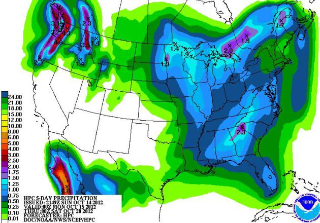
Rainfall By Friday Evening. Here is the high-res
HWRF model, showing some 1"+ amounts over Minnesota this week. Then
again, we all got excited last week at this time when models were
hinting at significant (Saturday) rain. That storm veered east. What can
go wrong this time? Stay tuned.
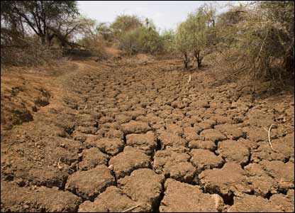
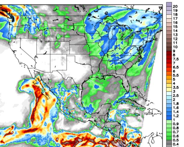
A Tiny Dent In The Drought?.
NOAA HPC is predicting some 1"+ rainfall amounts by Friday evening over
northern Minnesota and central Wisconsin and parts of the Great Lakes
as a cold upper level storm tracks overhead. Heavy rain and flash
flooding is possible in the Seattle/Tacoma area of the Pacific
Northwest.
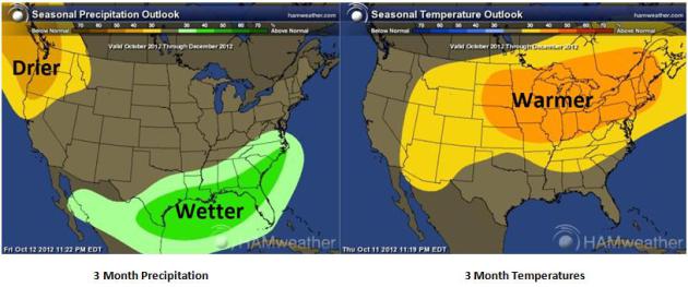
Very Extended Outlook. Based on a weak El Nino, NOAA
CPC is predicting a wetter October thru December for the far southern
USA, drier than average weather expected for the Pacific Northwest. Much
of the USA east of the Rockies is forecast to experience a warm bias
thru the end of 2012. Place your bets. Maps above:
Ham Weather.
“
We only have so many major physical features on the planet, four
or five, and you don’t really want to just start breaking them. That’s
why we can’t have nice things.” - 350.org enviromentalist Bill
McKibbon, appearing on HBO's "Real Time with Bill Maher". Check out one
of the more important video clips you'll watch this year, a 12 minute
interview from
grist.org. Image: NOAA/PMEL
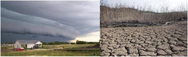
Expected Rain A Drop In Bucket. Amen to that. Bill McAuliffe at
The Star Tribune summarizes the state of our drought, and (growing) impact on lake and river water levels statewide; here's an excerpt: "...
Across
Minnesota, meanwhile, rivers and lakes are gasping. The St. Louis
River near Scanlon, which rose to a record height in June and tore
apart Jay Cooke State Park, was at what appeared to be its
second-lowest height in more than 60 years Wednesday. The Minnesota
River at Jordan was down to one-seventh of its historical average for
the date. State rivers are contributing so little to the Mississippi
that three-fourths of the water in the river downstream from La Crosse
is now from the Wisconsin and Chippewa rivers, according to Steve Buan,
hydrologist with the North Central River Forecast Center, an NOAA
agency based in Chanhassen. And Lake Minnetonka has dropped 1.5
feet since late June. The low rivers could mean problems later, Buan
said. Lack of flow allows logs and other debris to pile up, and can
create obstructions when the water rises..."
Photo credit above: "
Eden Valley farmer Tom Haag emptied
corn into a holding wagon used to shuttle the grain to a nearby
semi-trailer for transport back to the farmstead and a storage
container." Jim Gehrz, Star Tribune.
A Warm, Dry Bias. Here is an excerpt of last week's
WeatherTalk blog
from Mark Seeley: "This week NOAA also released a summary of national
climate conditions during September. Nationally it was the 23rd
warmest September on record, and the 16th consecutive month with above
normal temperatures. It was also a dry month, with near record setting
low statewide values for monthly precipitation in Minnesota, Montana,
North Dakota, and South Dakota. For the 2012 year so far the period
from January to September has been the warmest first nine months in the
USA climate records nationally. You can read more at
http://www.ncdc.noaa.gov/sotc/national/2012/9
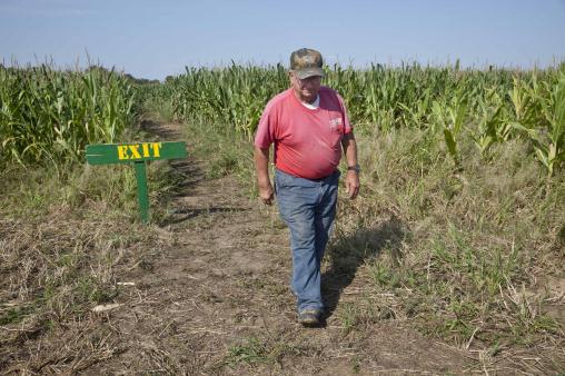
Photo credit above: "
In this photo taken Tuesday, Oct. 2,
2012, farmer Bob Schaefers walks from the exit of a trail through his
corn maze near Lollie, Ark. Devastating spring freezes and this year's
historic drought have taken some of the charm out of rustic fall
destinations, leaving some corn mazes too short for labyrinth duty,
orchards virtually devoid of U-pick apples and fall colors muted." (AP Photo/Danny Johnston)
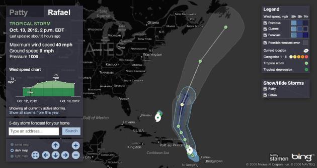
Tropical Storm Rafael Forms In Atlantic.
NBCNews.com has the details: "
After
forming Friday night, Tropical Storm Rafael was dumping rain across
the Less Antilles in the eastern Caribbean on Saturday. Up to 5 inches
of rain was expected, with a few spots potentially at 10 inches, making
for flood and mudslide conditions, the U.S. National Hurricane Center
said. Rafael, the 17th named storm of the Atlantic hurricane season,
will pass near or over the Virgin Islands Saturday night and eventually
accelerate northward..."
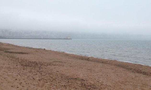
Taking In The Duluth Skyline. Walt Kruhoeffer sent
in this photo of the lakefront. The skyline is there...somewhere. 45 F
with drizzle in Duluth Saturday. In Duluth they call that a "warm
front."
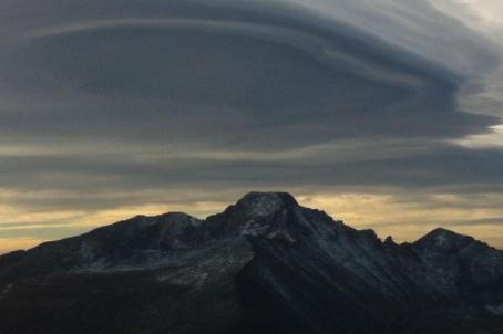
"Lenticularis". These massive wave clouds are formed
when air is forced up and over mountain ranges in a stable environment,
where temperatures warm with altitude. The result: smooth, lens-shaped
clouds, which are sometimes mistaken for UFO's! This
fine specimen is from Rocky Mountain National Park: "
Lenticular clouds, although beautiful, indicate that strong winds are present over the Fern Lake Fire today."
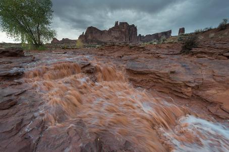
Muddy Rapids. Here's another terrific shot, this time of The Lower Park Avenue Falls at
Arches National Park.
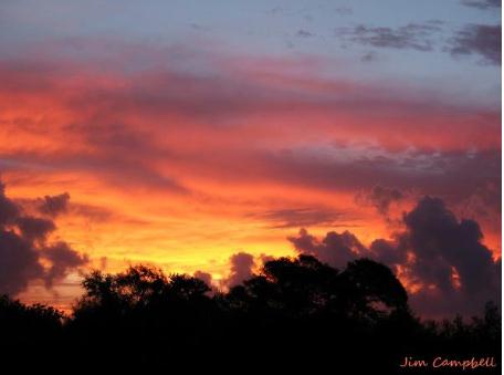
Red Sky At Night. Thanks to Jim Campbell and the
Brownsville office of the National Weather Service for sharing this one.
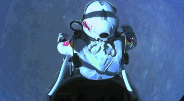
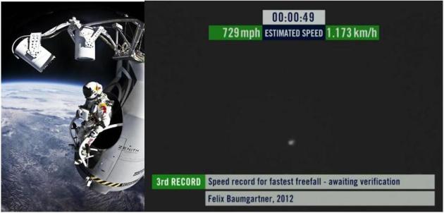
One (More) Additional Leap For Mankind. Did you
watch Felix Baumgartner jump from the edge of space yesterday, 24 miles
above Terra Firma? It was spellbinding stuff - one of the more
remarkable things I've witnessed recently. And yes, like many others I
was praying out loud for his safety. Turns out it was
picture-postcard-perfect. Why turn yourself into a 729 mph human
cannonball? Iron Man fixation? The high-tech, pressurized suit Felix
wore will continue to be tested and modified; some day soon it may
provide the ultimate escape for astronauts (and space tourists?) who get
into trouble, and need to make a quick escape back to Earth. Associated
Press has a good YouTube video summary of The Big Jump
here. I know it sounds like science fiction. So did going to the moon back in 1955.
Red Bull Skydive Team. The photo in the upper left
is one of my favorites - you can see the curvature of the Earth from
that lofty altitude! Do you think this guy had butterflies? Mission
Control: "
Felix, your testosterone levels are 113." Copy that. "
On a scale of 1 to 10". Impressive doesn't quite sum up what this guy did yesterday.
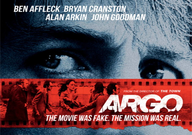
Go See "Argo". I'm not in the habit of plugging
movies, but Ben Affleck has created a masterpiece with "Argo", the story
of a secret rescue mission of American Embassy hostages in Iran more
than 30 years ago. The fact that the story is real makes it even more
remarkable. If nothing else you'll enjoy the late 70s flashback (did we
really dress that badly and smoke that much?) Maybe so. Faking a movie
in Tehran was a stroke of genius - so crazy it actually worked.
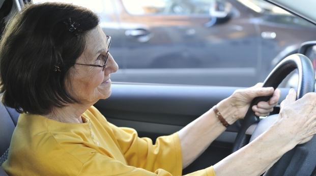
When Should Seniors Hang Up The Car Keys? Here's a dilemma many of us face with parents and grandparents.
NPR takes a look at how others have approached this problem; here's an excerpt: "
With a growing population of baby boomers, officials are bracing for a surge in senior drivers. Statistics tell us that accidents increase after the age of 65, and fatal accidents are more likely after the age of 75. Canada requires physicians to report any concern about a patient's ability to drive, and they are being paid every time they warn a patient. But there's no such requirement here in the U.S. While some seniors
opt for public transportation, others stick to the roads. So, often
it's up to family members to help seniors decide when it's time to give
up the car keys..."
Photo credit above:
Martin Novak/iStockphoto.com. "
More
elderly drivers will hit the road in the next decade, but family
members wonder: When is it time for elderly loved ones to move to the
passenger seat?"
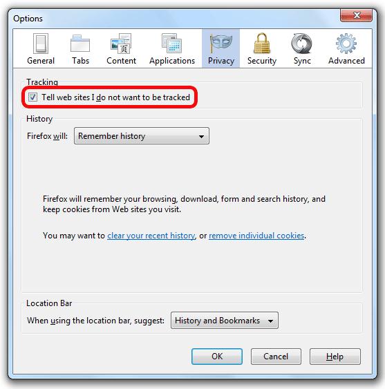
Do Not Track? Advertisers Say "Don't Tread On Us." The New York Times
has an interesting article, which underscores a meme I continue to hear
about the 'net. If the service or product is "free" YOU are the
product, your advertising and personal preferences bought, traded and
sold to potential merchants and marketers. Nothing wrong with that, as
long as you know exactly what's going on. Here's an excerpt of the NY
Times story: "...
The advent of Do Not Track threatens the barter
system wherein consumers allow sites and third-party ad networks to
collect information about their online activities in exchange for open
access to maps, e-mail, games, music, social networks and whatnot.
Marketers have been fighting to preserve this arrangement, saying that
collecting consumer data powers effective advertising tailored to a
user’s tastes. In turn, according to this argument, those tailored ads
enable smaller sites to thrive and provide rich content. “If we do away
with this relevant advertising, we are going to make the Internet less
diverse, less economically successful, and frankly, less interesting,”
says Mike Zaneis, the general counsel for the Interactive Advertising Bureau, an industry group."
* I use Mozilla Firefox. If you upgraded to the latest version the
"Do Not Track" function is set as a default. If not go into Tools,
Options, Privacy, and make sure "Tell web sites I do not want to be
tracked" is checked. It'll take you 5 seconds.
The Secret To Genius? It Might Just Be More Chocolate.
Forget the broccoli, my diet consists entirely of dark chocolate and
red wine. Stay tuned for updates. Here's an excerpt of another (slightly
tongue-in-cheek) NPR story that caught my eye: "...One
rainy afternoon, while stuck in a Katmandu hotel, Messerli got to
playing around with the data. When he plugged in numbers from 23
countries, they made a neat linear plot on the page: Not only was the
correlation between chocolate consumption and Nobel Prize winners very
significant, but the probability that the distribution was due to chance
— what researchers call the "p-value"
— was tiny. "I have published about 800 papers in peer-reviewed
journals," he says, "and every single one of them stands and falls with
the p-value. And now here I find a p-value of 0.0001, and this is, to
my way of thinking, a completely nonsensical relation. Unless you — or
anybody else — can come up with an explanation. I've presented it to a
few of my colleagues, and nobody has any thoughts."
Photo credit above:
funny-potato.com.
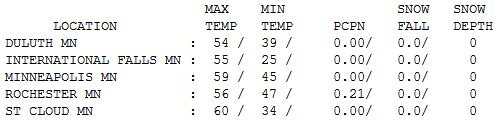
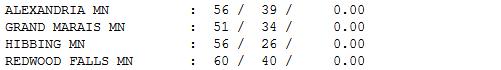
Nice To Be "Average". After a few chilly days in a
row it was nice to see a (Sunday) with temperatures right where they
should be in mid-October: mid 50s to low 60s. After a gray, soggy, foggy
start (.21" rain in Rochester) a dry northwest wind kicked in, treating
us to sunshine by afternoon. Highs ranged from 51 at Grand Marais to 59
Twin Cities, 60 at St. Cloud and Redwood Falls.
Paul's Conservation Minnesota Outlook for the Twin Cities and all of Minnesota:
TODAY: Partly sunny and pleasant with less wind. Winds: SW 5-10. High: 63
MONDAY NIGHT: Mostly clear, not as chilly. Low: 50
TUESDAY: Unseasonably mild! Fading sun, PM shower? High: 72
WEDNESDAY: Cooler with a better chance of showery rain. Low: 53. High: 58
THURSDAY: Cold rain (few flakes mixing in Thu. night?) Low: 41. High: 44
FRIDAY: Slow clearing, chilly breeze. Low: 37. High: 53
SATURDAY: Blue sky, turning milder again. Low: 38. High: near 60
SUNDAY: Lukewarm sun. Looking good. Low: 44. High: 68
* a few days at or above 70 are possible early next week.
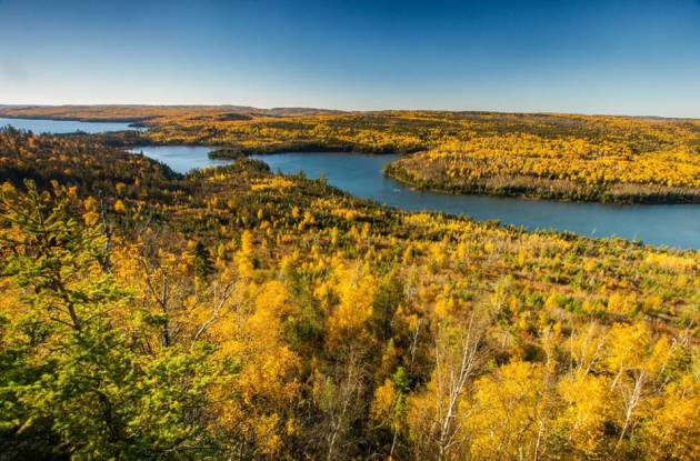
** Boundary Waters photo above courtesy of Steve Burns.
Weather Whiplash
The trends are baffling. According to Dr. Mark
Seeley severe drought has been observed somewhere in Minnesota every
summer since 2005. Yet many towns have experienced a 10-30 percent
increase in rain over the last 30 years.
Minnesota is the 3rd fastest-warming state in
the USA. A warmer atmosphere can hold more water vapor, loading the dice
for more extreme rainfall events - and summer heat waves. "Since the
80s all of Minnesota's heat waves have been driven by high dew points,
not air temperature" Seeley reported in a recent climate seminar.
So let me get this straight: rainfall is increasing, but so is drought?
Yep.
Wild swings will create new opportunities for
heat & drought-resistant crops and turf - and storm sewers able to
withstand more frequent deluges.
We still see T-storm downpours, but where are the steady, 2-day soakings I remember from my youth? Odd.
Showers Wednesday give way to a cold rain
Thursday, as a chilly upper level low rotates overhead. Flurries mix in
Thursday night; no accumulation expected.
More whiplash: skies clear next weekend; the ECMWF model hinting at 70s in a week.
"Only in Minnesota can you be ankle-deep in mud - with dust blowing in your face!"
Climate Stories...
Can Climate Change And Evangelicals Coexist? My
fervent hope is that the answer is a resounding yes. Time will tell, but
I'm encouraged by the number of people, with strong spiritual
convictions, who see climate change for what it really is: a moral and
ethical challenge unlike anything we've ever encountered before, and
also a question of stewardship and taking responsibility for our
actions. Here's an excerpt of a post at
care2.com: "
I’m a strong believer that climate change is the highest moral issue of our time.
Just because one is a conservative, or religious, or some combination
of both; there is no reason to ignore the climate crisis. Young people
of all political and religious persuasions are teeming with ambition
and enthusiasm and want to take on the world’s problems. Want to know
what is so awesome about this fact? When young men and women are
passionate about something before they become parents carry their
convictions with them once their lives are forever changed by diapers
and 2 am feedings. This is true for a young group that is pushing the presidential candidates to talk about global warming.
Young Evangelicals for Climate Action
Recently, I was introduced to the Young Evangelicals for Climate Action (YECA) and my heart was warmed by the energy of this group. Every member of the steering committee is less than 30 years old, well-educated and passionate about showing the religious community that it is our responsibility to work as citizens of a nation
to influence action against climate change. They believe God holds
Christians accountable for caring for the Earth. And each member of YECA
is committed to educating others of this responsibility...."
Carbon Dioxide May Damage Glaciers, Researchers Suggest. Here's a segment of a fascinating bit of research, reported at OurAmazingPlanet and
Huffington Post: "
A
computer model of carbon dioxide in ice cracks has two MIT researchers
speculating that the greenhouse gas could structurally weaken
glaciers, which are already under pressure from global warming.
Materials scientist Markus Buehler, a professor at MIT, studies the
mechanical properties of fracturing in everything from spider silk to
bones. He works on a nano-sized scale, looking at the bonds between
molecules and atoms. Even an iceberg the size of Manhattan
starts with a single broken bond, so Buehler and postdoctoral scholar
Zhao Qin decided to investigate what happens when ice fractures. They
were particularly interested in how carbon dioxide gas, which
contributes to global warming, might affect fracturing in ice..."
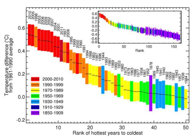
"Global Warming Stopped 16 Years Ago"? That was the headline that appeared in the U.K.
Daily Mail
over the weekend. The reality is something different altogether. It all
comes down to cherry-picking which years you choose to graph, and
taking an (honest) look at the real trends. Here's a response from the
U.K. Met Office: "...
The
linear trend from August 1997 (in the middle of an exceptionally
strong El Nino) to August 2012 (coming at the tail end of a double-dip
La Nina) is about 0.03°C/decade, amounting to a temperature increase of
0.05°C over that period, but equally we could calculate the linear
trend from 1999, during the subsequent La Nina, and show a more
substantial warming. As we’ve stressed before, choosing a starting or
end point on short-term scales can be very misleading. Climate change
can only be detected from multi-decadal timescales due to the inherent
variability in the climate system. If you use a longer period from
HadCRUT4 the trend looks very different. For example, 1979 to 2011
shows 0.16°C/decade (or 0.15°C/decade in the NCDC dataset,
0.16°C/decade in GISS). Looking at successive decades over this period,
each decade was warmer than the previous – so the 1990s were warmer
than the 1980s, and the 2000s were warmer than both. Eight of the top
ten warmest years have occurred in the last decade..."
* Global Rank of Hottest Years To Coldest
graph above courtesy of the U.K. Met Office.
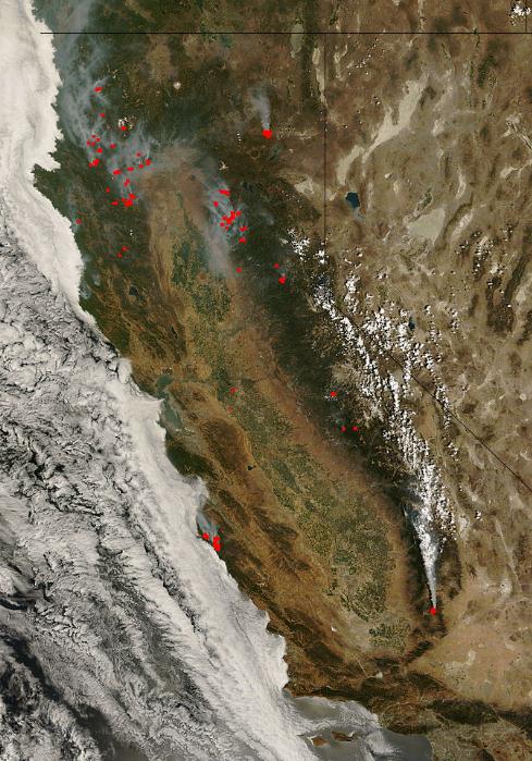
A Grand Experiment To Rein In Climate Change. All eyes are on California to see if cap and trade can work, without pushing industry out of the state.
The New York Times has the story - here's a clip: "...
Such audits will be crucial as California embarks on its grand experiment in reining in climate change.
On Jan. 1, it will become the first state in the nation to charge
industries across the economy for the greenhouse gases they emit. Under
the system, known as “cap and trade,”
the state will set an overall ceiling on those emissions and assign
allowable emission amounts for individual polluters. A portion of these
so-called allowances will be allocated to utilities, manufacturers and
others; the remainder will be auctioned off. Over time, the number of
allowances issued by the state will be reduced, which should force a
reduction in emissions..." Image: NASA and U.S. Forest Service.
Fisher: There May Be More To The Arctic Thaw Than Global Warming. The Vancouver Sun has the story - here's an excerpt: "
Conversations
with half a dozen of Russia’s top northern experts over the past few
weeks have led me to several firm conclusions. In what appears to be a
deliberate tension-reducing mode, the Russians I spoke with carefully
stressed how potentially explosive issues such as which of the
countries with competing claims in the Arctic Ocean – Russia, Canada,
Denmark (for Greenland) and the U.S. – will get what share of the top
of the world must be achieved through consultation rather than by
provocative rhetoric or actions. It was equally plain from speaking
with the Russians that their country remains far more capable of
operating in the High Arctic than any potential rivals. Moreover, to
build on the lead they inherited from the Soviet Union, they are
already devoting more resources and intellectual energy than anyone
else..."
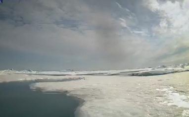
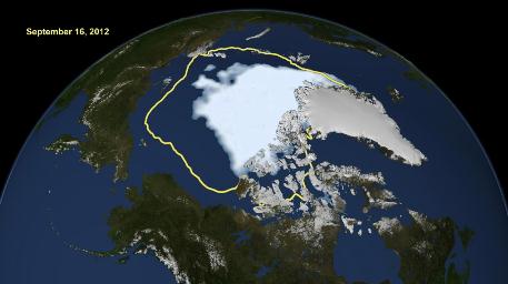
Image credit above: "
NASA handout image shows how
satellite data reveals how the new record low Arctic sea ice extent,
from September 16, 2012, compares to the average minimum extent over
the past 30 years (in yellow). " Photograph by: (REUTERS/NASA/Goddard Scientific Visualization Studio/Handout) , Postmedia News
Northeastern Minnesota Experiment To Study Effects Of Climate Change. The details in a story at
Northland's NewsCenter; here's an excerpt: "...
Funded
by the U.S. Department of Energy, the project is a collaborative
effort between the USDA Forest Service and Oak Ridge National
Laboratory, which is located in Tennessee. Once up and running, the
experiment will slowly heat 12 to 16 transparent chambers, which will
be about 30 feet tall and 40 feet in diameter. The scientists will
slowly heat the chambers to various temperatures, measuring how the
entire ecosystem, from soil to treetops, responds to elevated
temperatures and carbon dioxide levels. "This tower resides in the
center of those chambers and represents the means by which we can
document how warm our little plot of ecosystem has become," said Oak
Ridge National Laboratory researcher, Paul Hanson, of a large tower,
waiting to be placed in the area where the chambers will eventually be..."
Some Climate Scientists, In A Shift, Link Weather To Global Warming. Details from the
L.A. Times; here's a clip from the main story: "...
Extreme
events like drought, heat waves, intense rainfall, flooding and fires
have prompted many people to reconsider the connection between the
weather and the changing climate. Now, a handful of scientists are
among them. In a break with the mainstream scientific consensus, a few
prominent climate scientists now argue that there have been enough
episodes of drought and intense heat in the last 10 years to establish a
statistical pattern of extreme weather due to global warming..."
Researchers Find Link Between Arctic Meltdown And Summer Floods And Fires. The story from Climatewire and
Scientific American - here's an excerpt: "
A new weather
pattern that sends blasts of warm southern air into the Arctic each
June has fueled the recent, dramatic decline of the region's sea ice,
according to a new government-funded study. But that is not all it has
done, the analysis suggests, linking the shifting summer winds to
record thaws of the Greenland ice sheet, unusually wet European summers
and Rocky Mountain wildfires. Researchers say the switch from light,
variable east-west winds to stronger, warmer blasts of southern air
appears to have strengthened a climate feedback loop they call "Arctic
amplification."
Climate Change: Winning Issue Or Losing Battle?
Notice how neither President Obama or Gov. Romney is talking much about
climate change, and their plans to grow the economy without making the
warming, and subsequent extreme weather, that much worse by increasing
our dependence on fossil fuels.
Climate Science Watch has the story; here's a clip: "
Recent, fascinating, and underutilized national polls (also here and here) suggest climate change can be a winning issue in the 2012 elections. A panel of experts, hosted by Climate Desk,
discussed these key questions in Washington, DC, on October 10: With
this recent polling data, why are the President and other political
leaders still not talking about climate change? How can effective
communication between political leaders and the public be stimulated?
Betsy Taylor, President of Breakthrough Strategies & Solutions
and well-known driving force in numerous public interest
organizations, confirmed that climate change has been stifled from
public discourse. In the spring of 2009, after the financial crisis
had hit, “there was a decision made,” Taylor says, “to not talk about
climate change that was adopted by the majority of the environmental
groups and the White House. I was at that meeting.” Reluctantly, the
environmental organizations agreed, while some argued this decision
would come back to “haunt” them. They were right about climate change
haunting us, though the public discourse remains dysfunctional."
Hottest Year So Far In Philadelphia. And a large chunk of the USA, for that matter. Here's an excerpt from a story at
philly.com: "
2012
is on pace to be the warmest on record in more than 100 U.S. towns and
cities, including Philadelphia, and for the continental United States
as a whole, according to the National Oceanic and Atmospheric
Administration. Philadelphia has certainly seen some extremes in recent
years. 2011 was Philadelphia's wettest year on record, with
precipitation equalling 64.33 inches of water. The winter of 2009-10
had the most snow ever, 78.7 inches. For the first nine months of 2012,
Philadelphia's average temperature was 62.2 degrees, 3.5 degrees above
the average during the two decades from 1981 to 2010. The city's
record covers the last 65 years..."
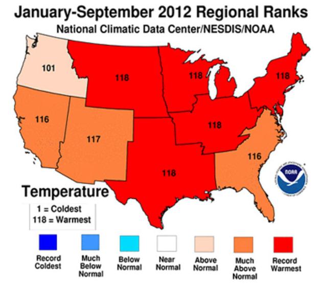
Graphic credit above: "
The continental U.S. had its
hottest average temperature in 118 years, according to federal
researchers. Five of eight regions also set records (in red), while
three others had their second or third highest average temperatures.
The Pacific Northwest was also "above normal."
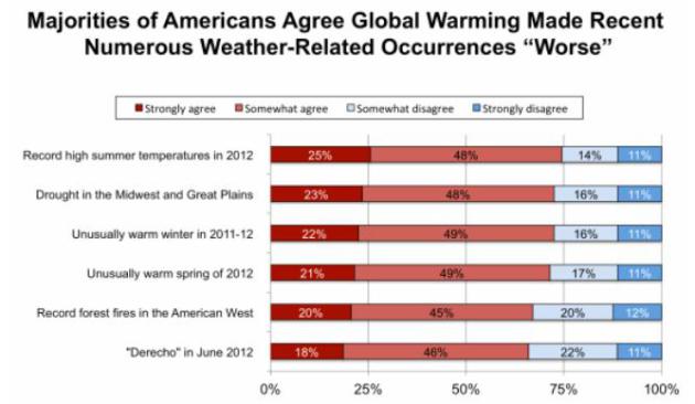
Yale Poll: Large And Growing Majority Of Americans Say "Global Warming Is Affecting Weather In The United States." Here's a snippet from a story at
Think Progress: "
Yet
another survey finds that the public accurately understands global
warming makes extreme weather events worse. This new poll from George
Mason University and Yale’s Project on Climate Change Communication matches the finding of a February Brookings poll
that found Americans’ understanding of climate change was increasing
with more extreme weather and warmer temperatures. Heck, the weather has
been so off the charts that even the major media have taken notice
(see Every Network Gets Extreme Weather Story Right, ‘Now’s The Time We Start Limiting Manmade Greenhouse Gases’ — ABC). And the public’s understanding certainly matches the science (see “Has Global Warming Caused A Quantum Jump In Extreme Weather?” and links below)."


No comments:
Post a Comment