62 F. high in the Twin Cities Wednesday.
58 F. average high for October 17.
58 F. high on October 17, 2011.
Trace of rain fell at KMSP
yesterday.
32 mph: peak wind gust yesterday (1 pm).
.28" rain predicted by midday Friday (00z NAM).
Mid-60s Sunday; mildest day in sight.
3" rain next Tuesday thru Thursday (ECMWF)
 60-Hour Rainfall Forecast.
 The 4 km NAM from NOAA
NCEP
shows a huge variation in predicted rainfall amounts across the state;
around .2" for St. Cloud, closer to .3 to .4" for the Twin Cities, but
over an inch for far western Minnesota.
Sliding Into A Wetter Pattern? The ECMWF (European) model prints out over
3" of rain
between Tuesday and Thursday of next week. It's still too early to
celebrate (last Saturday's rainy no-show comes to mind) but I'm seeing
signs of more substantial moisture reaching Minnesota and Wisconsin by
next week. In the meantime Sunday looks like the milder day of the
weekend (mid 60s possible), with mild weather lingering into the first
half of next week. By late next week it may feel a little more like
early November out there.
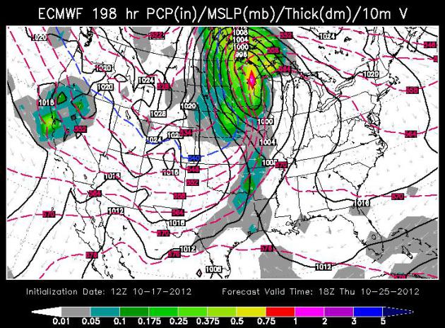
Hold The Presses: A Real Storm? The ECMWF spins up a
major storm over the Upper Midwest next Wednesday and Thursday, drawing
on a large temperature contrast (baroclinicity) - a deep cyclone
spinning up along the leading edge of a Novemberlike airmass. It looks
promising, but it's a week away - much that can change between now and
then.
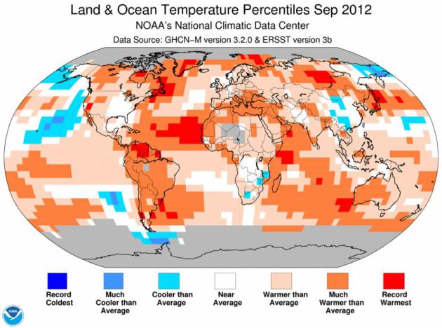
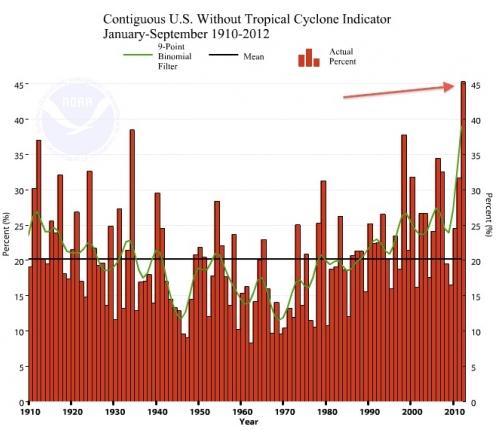
Warmest September On Record, Worldwide. "
This is
the 16th time that the world has set or tied a hot temperature record
since 2000, according to NOAA. The last time the world set a cold
temperature record was in December 1916, nearly 96 years ago..." - excerpt from a story at Sci-Tech Today; details and links below. Image: NOAA NCDC.
"...
Thanks to large-scale heat waves and a massive drought, 2012
has been the most extreme weather year on record in the lower 48
states, as measured by the National Climatic Data Center’s Climate
Extremes..." - excerpt from a Climate Central story, details below.
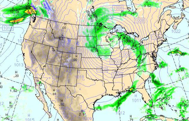
Today's Weather Map. The WRF model, valid at 4 pm
today, shows a deep area of low pressure centered close to the Twin
Cities, the heaviest rain bands surrounding the metro area - some .5 to
1" rainfall amounts from the Red River Valley south to Sioux Falls and
Des Moines. We will be in the "eye of the storm", with .1 to .2" rain
possible in the Twin Cities. Strong to severe T-storms push into the Mid
Atlantic region, while the west stays dry. A big contrast in air
pressure whips up some 30-50+ mph winds over the Dakotas, where High
Wind Warnings are posted by NWS.
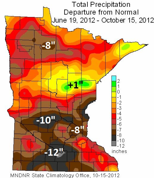
Drought Update: June Thru Mid-October 2012. Details from the
Minnesota Climatology Working Group: "
The
moisture deficits in southern Minnesota developed rapidly due to very
hot and very dry conditions during the mid-summer and into the autumn.
Over the period, rainfall totals in many Minnesota counties fell short
of average by six or more inches. This is the climatological equivalent
of missing nearly two months of growing season precipitation. In some
southern Minnesota communities, mid-summer through autumn rainfall
deficits are in excess of eight inches."
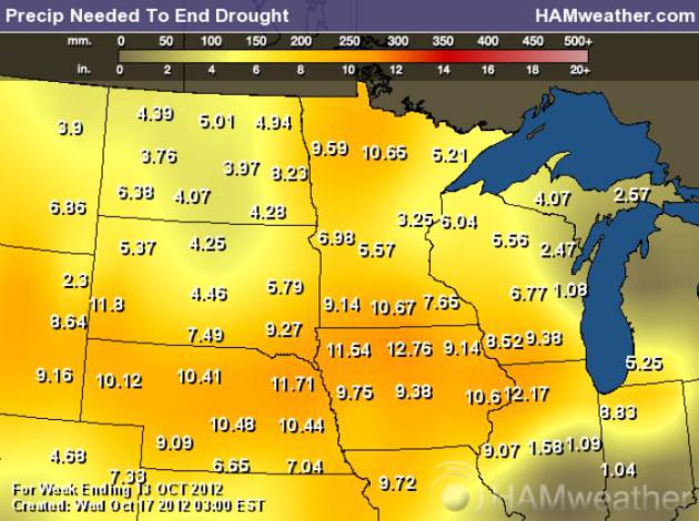
Rainfall Needed To Break The Drought. According to
NOAA and USDA anywhere from 5 to 10.5" of rain is necessary to erase the
impact of a deepening drought. We're heading into a wetter pattern, but
it's doubtful we'll see this much rain, statewide, before the ground
freezes up solid within 30-40 days. Map above:
Ham Weather.
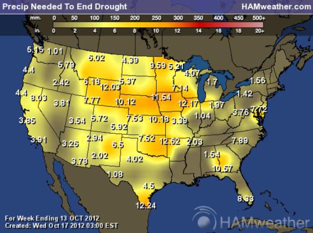
Expanding Drought. On a national scale you can see,
at a glance, how much rain is required to end the drought. Although the
worst conditions extend from the Rockies to the Midwest, unusually dry
weather is showing up from Georgia (10.5" deficit) to the D.C. area
(7.7" rainfall shortage). Map: USDA, NOAA and
Ham Weather.
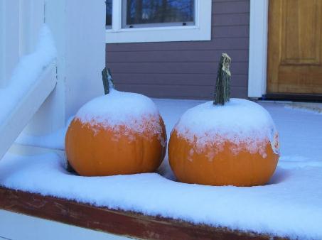
Winter Is Back In Breck. Nothing better than
snow-covered pumpkins - courtesy of the town of Breckenridge, Colorado.
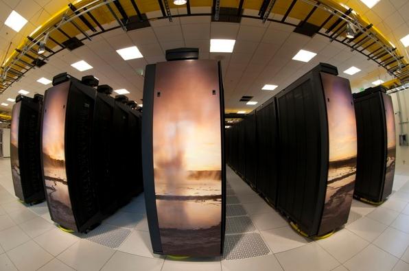
The World's Most Powerful Climate Change Supercomputer Powers Up. Here's the intro to a fascinating story at
Time Magazine: "
For all the political discord
over climate change, one thing everyone can probably agree on is that
when you’re throwing computational resources at modeling weather, the
more the merrier. Think of the new computer that just came online at the
NCAR-Wyoming Supercomputing Center in Cheyenne, Wyoming as a kind of
dream come true from a meteorological standpoint, then, because it
represents a mammoth increase in raw crunch-prowess, dedicated to
studying everything from hurricanes and tornadoes to geomagnetic
storms, tsunamis, wildfires, air pollution and the location of water
beneath the earth’s surface..."
Photo credit above: Carlye Calvin / NCAR. "
A fish-eye
view of some of the Yellowstone supercomputer's 100 racks. An iconic
scene from Yellowstone National Park is featured mosaic-style on the
ends of each rack."
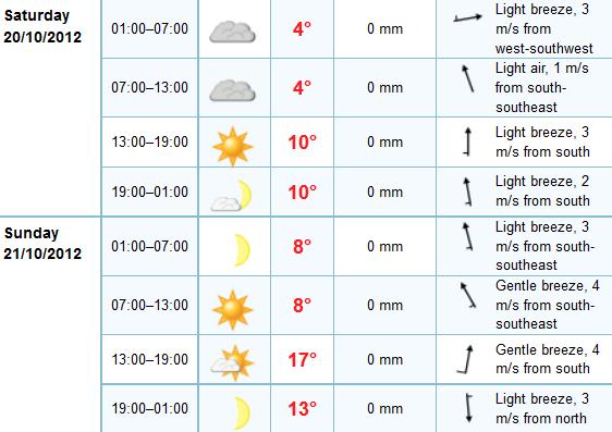
Weekend Details. The ECMWF suggests patchy clouds
Saturday morning, enough PM clearing for highs in the low to mid 50s.
Sunday looks sunnier and 5-10 degrees milder with a south breeze and
highs well up into the 60s. Note to self: get your power-leaf-raking
done on Sunday. A soggy-leaf-alert is in effect next week.
A Cooler Front.
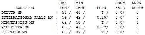
The transition from 60s to 40s whipped up 30+ mph wind gusts yesterday,
highs (early) ranged from 52 at Alexandria (.25" rain) to 62 Twin
Cities to 65 at St. Cloud.
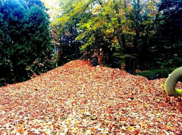
Leave Me Alone! There's a kid in that pile of
leaves...Crosby. Thanks to his dad, WeatherNation TV meteorologist Todd
Nelson, for sending this in from St. Michael.
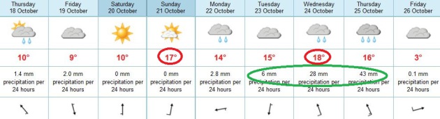
Paul's Conservation Minnesota Outlook for the Twin Cities and all of Minnesota:
TODAY: Clouds and Showers. Heavier rain far western Minnesota. Winds: NW 10-15. High: 49
THURSDAY NIGHT: Windy and raw with more showers. Low: 42
FRIDAY: Lingering showers, still chilly and damp. High: 48
SATURDAY: Early clouds, then plenty of sun, much better. Low: 39. High: 54
SUNDAY: Blue sky - Indian Summer returns! Low: 44. High: 66
MONDAY: Clouds increase, late shower? Low: 49. High: 61
TUESDAY: Mostly cloudy, damp - late showers. Low: 51. High: 62
WEDNESDAY: Still mild and humid for October. Heavier, steadier rain. Thunder? Low: 52. High: 68
A Wetter Pattern?
Yesterday's windswept cool front brought more
dust than rain. Statewide, the last 60-90 days have been some of the
driest on record across Minnesota. The entire state is in moderate
drought, with severe drought expanding across the Twin Cities metro.
Heavy rain would be nice.
Don't get your hopes up today - the heaviest
spiral bands of rain will soak far western Minnesota and the Dakotas; a
few light showers in the cities.
But I'm finally seeing some signs that our dusty
pattern may be drawing to a close. Long range weather models show a
front stalling over the Upper Midwest next week.
A series of storms rippling along this boundary could set the stage for more significant rain by the middle of next week.
According to NOAA's Palmer Index, most of
Minnesota needs 6 to 11 inches of rain to eliminate the drought. That
won't happen anytime soon, in fact we may not pull out of the drought
until 2013 at the rate we're going.
The next couple of weeks are critical. We need a
few inches of rain before the ground freezes up in November, to ensure a
good start to the 2013 growing season.
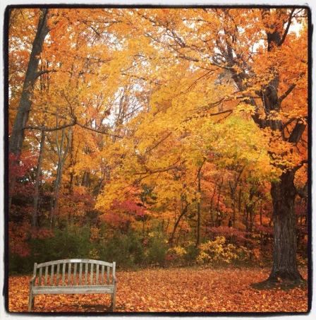
Showery rains linger into Friday. Skies clear Saturday with balmy 60s possible on Sunday!
* photo of Bernheim Forest, Kentucky above courtesy of Laura Pell DeCarlo
Climate Stories...
Climate Change "Footprint" Cited In Disaster Loss Trends. Meteorologist Andrew Freedman helps to connect the dots in this
Climate Central story - here's an excerpt: "...
The
new and most controversial finding in the report is that the upward
trend in weather-related disaster losses is being driven in part by
manmade global warming, since previous studies have shown that
socioeconomic factors, such as population growth and urban sprawl, are
behind this trend. At the same time, however, studies have increasingly found that global warming is already making certain types of extreme weather events, such as heat waves and precipitation extremes, more likely to occur and more severe. The study, which Munich Re
described as being aimed partly at galvanizing action on global
warming, discusses ties between global warming and thunderstorm-related
losses, which peaked in 2011. That year there was $26 billion in
insured property losses from thunderstorm-related hazards, such as
hail, strong winds, and tornadoes. The study concludes that both urban
sprawl and climate change are drivers of the increased thunderstorm
costs...."
Graphic credit above: "
2012 has, so far, had the most extreme weather on record in the lower 48 states, according to the Climate Extremes Index." Credit: NOAA/NCDC.
Climate Change A No-Show Again, Despite Debate's Energy Focus. Here's an excerpt from
The Hill's Energy and Environment Blog: "....“
Both
candidates vied to restate their commitment to more dirty oil, gas and
coal production while ignoring the contradiction between an ‘all of
the above’ energy program and reducing emissions of climate disrupting
gases,” said Erich Pica, president of Friends of the Earth Action, in a
statement. Candy Crowley of CNN, the debate moderator, indicated
afterward that she had a climate change question ready but was unable to
get to it. Much of the debate time was taken up by the candidates
interrupting each other, as well as Crowley. The liberal Chris Hayes of
MSNBC, during the network’s post-debate analysis, likened the
climate-free energy portion to discussing smoking without discussing
cancer."
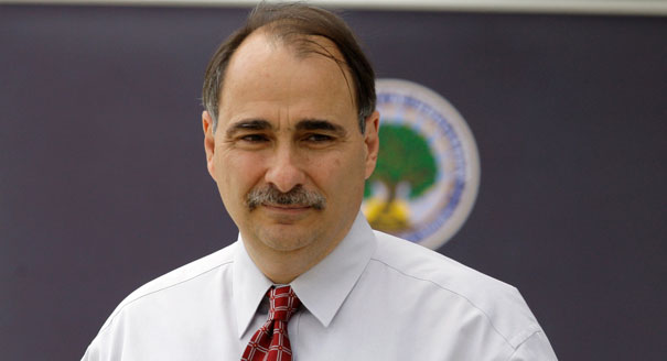
Is David Axelrod To Blame For Climate Change's Absence From The Election? The Atlantic speculates - here's a clip: "
Warming
could be a winning issue, but President Obama isn't pushing on it --
and experts finger one of his top aides as the culprit. "It was
always going to be the case that whenever the visible reality of
climate change became so painfully obvious that you couldn't deny it
any more, that it was going to flip over to a winning issue. The
question was: When was that going to happen?" So said Joseph Romm, the former Clinton energy official and popular blogger behind Climate Progress, at the first Climate Desk Live briefing at the Mott House on Capitol Hill. Romm and his fellow panelists -- strategist Betsy Taylor of Breakthrough Strategies and Solutions and consultant Paul Bledsoe,
who worked in the Clinton White House on climate communications --
were in strong agreement that the weather of the last year has
transformed climate change into the type of issue that could impact the 2012 election, simply because most Americans now feel directly affected by it. That emphatically includes independents and swing voters...." Photo: politico.
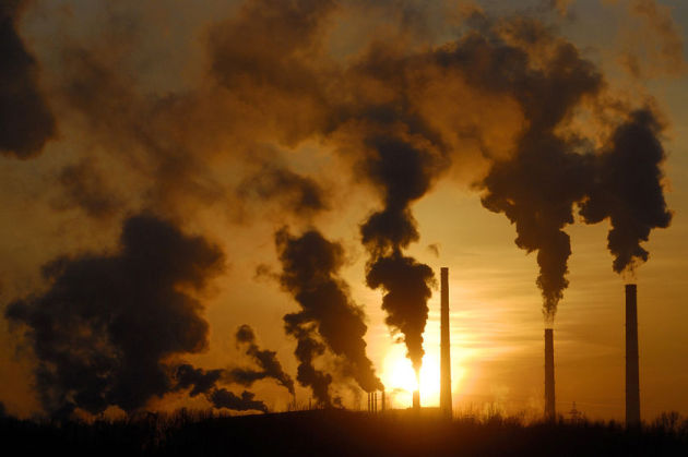
Hot September: Man-Made Global Warming At Work. Here's an excerpt from
Sci-Tech Today: "
The
world last month matched a record for the hottest September, and some
scientists point to global warming as a cause. It was the third time
since 2000 that the world set or tied a heat record for September.
Previous hot September records were set in 2003 and 2005. The records
go back to 1880. Last month's average temperature was 60.2 degrees (15.6
Celsius) Fahrenheit worldwide, the U.S. National Oceanic and
Atmospheric Administration said Monday. Why September? It might be the
lengthening of the Northern Hemisphere summer as a result of man-made
global warming and the loss of Arctic sea ice that indirectly helps
cool other parts of the world, said University of Victoria climate
scientist Andrew Weaver..."
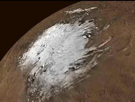
Computer Models Of Earth's Climate Change Confirmed on Mars. The story from Reuters and
wkzo.com: "
WASHINGTON
(Reuters) - Computer models have accurately forecast conditions on
Mars and are valid predictors of climate change on Earth, U.S. and
French astronomers said on Tuesday. These computer programs predicted
Martian glaciers and other features on Earth's planetary neighbor,
scientists found. "Some public figures imply that modeling of global
climate change on Earth is 'junk science,' but if climate models can
explain features observed on other planets, then the models must have
at least some validity," lead researcher William Hartmann of the
Planetary Science Institute said in a statement. The team's findings
were presented at the annual meeting of the American Astronomical
Society's planetary sciences division in Reno, Nevada..."
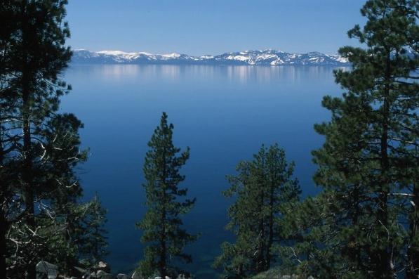
Warming Lakes: Effects Of Climate Change Seen On Lake Tahoe.
National Geographic takes a look - here's a snippet from the story: "
Lake
Tahoe is one of hundreds of lakes around the world in the midst of a
warming trend. The effects of climate change are starting to complicate
efforts to maintain the lake’s relatively pristine state, putting
Tahoe’s sapphire blue water and its overall ecological health at risk.
Surrounded by the Sierra Nevada Mountains and stunning scenery, the
lake straddles the border between California and Nevada. At 1,645 feet
deep, Lake Tahoe is one of the deepest lakes in the world. It is also
one of the world’s oldest, at about two million years. Water resides in
the lake for about six hundred years and flows out through only one
outlet: the Truckee River..."
Photo credit above: Lake Tahoe. Photo by Brent Allen, TERC.
Republicans, Once Again, See Evidence Of Global Warming.
Slate.com has the story and Pew poll results; here's a clip: "...
According to a new survey from the Pew Research Center,
48 percent of self-identified Republicans said there is "solid
evidence" of climate change. That number is up 5 points from last year
and 13 points from 2009. Still the figure is lower than what it was in
2006 and 2007, and right about where it stood in 2008.
Here’s Pew with more:
A majority of moderate
and liberal Republicans (58%) say there is solid evidence of warming,
including 38% who say it is mostly due to human activity. By contrast,
only 43% of conservative Republicans say there is evidence of warming,
while 51% say there is not. However, more conservative Republicans say
there is evidence of warming than did so last year. In 2011, just 31%
said the earth has been warming while 60% said there was no solid
evidence of warming..."
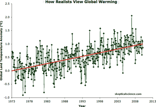
Did "Global Warming Really Stop In 1997?" The short answer is no. Anyone can cherry-pick specific beginning and ending dates to "prove" virtually anything, but as
msnbc.com points out in this article, the truth of what's happening worldwide is apparent: "
Claims
global warming stopped 15 years ago are based on "cherry-picked" data
and don't account for natural fluctuations in climate, according to
climate scientists responding to an article that appeared Saturday
(Oct. 13) in the British newspaper, The Daily Mail. The article
cites combined global land and sea-temperature data compiled by British
climate researchers, claiming that between August 1997 and August
2012, " there was no discernable rise in aggregate global temperatures." The implication, writes the article's author David Rose, is that computer models, including those used by UN's Intergovernmental Panel on Climate Change, are flawed and have made overly dire predictions..."


michelleding: It brought with it quite a wedding dress shops
ReplyDeletehttp://michelleding.livejournal.com/15132.html
http://crosquare.com/blogs/entry/The-color-in-your-promenade-prom-suits
http://sunglasses1114.jigsy.com/entries/general/the-method-of-making-a-tattoo-online
http://dantecorde.blog.fc2.com/blog-entry-2.html
http://dantecorde.webs.com/
http://sunglasses1114.deviantart.com/journal/#/d5qke9w
http://hireoneveteran.com/index.php/blogs/4255/13946/you-possess-a-superb-position-su
http://20913093.blog.hexun.com/82456894_d.html
http://dantecorde.cocolog-nifty.com/blog/2013/01/exactly-what-ar.html
http://dantecorde.blog.co.uk/2013/01/06/the-chosen-shade-is-tattoo-online-has-not-changed-15400035/
http://blog.newdu.com/user1/17532/archives/2013/556248.shtml
http://en.netlog.com/hubailong/blog/blogid=16322980
http://jhjbafr.dhpreview.devhub.com/blog/1109863-guantee-that-the-jacket-on-the-wedding-suits/
http://costoflife.ning.com/profiles/blogs/in-a-single-cheap-flower-girl-dresses-working-day
http://blog.5u588.com/u/2140/archives/2013/30949.html
http://corde.hatenablog.com/entry/2013/01/06/110649
http://www.flixya.com/blog/5127630/The-colour-prom-suits-on-your-promenade-
http://hubailong88.blog.com/2013/01/06/the-tattoo-device-the-artist-uses-to-create-the-look/
http://2eyeglasses.blogspot.com/2013/01/this-may-be-your-desire-earth-any-free.html
http://ameblo.jp/corde/entry-11443170594.html