23 F. high temperature in the Twin Cities Monday.
35 F. average high for November 26.
50 F. high on November 26, 2011.
50 F. high possible Saturday (light rain showers possible).
55-60 F. next Monday? Expect an unusually mild start to December.
No big storms in sight looking out 10+ days.
Winter Shrinkage
Meteorologists and climate scientists look for
patterns amidst the noise, nuggets of wisdom in a sea of weather chaos
and normal variability. The weather has never been "normal" - we've
always had uncomfortable, and at times life-threatening, ups and downs
and extremes. That's a given.
An estimated 90 percent of all warming is going
into oceans and lakes. In addition to powering hurricanes &
Nor'easters, warmer water can mean a shorter ice season on the Great
Lakes. More open water creates a longer season for lake-effect snows
downwind.
I expect another shortened ice fishing season
this winter. I still expect a 2-4 days at or above 50 F from Saturday
into late next week; almost 20 degrees above average.
Any puffs of Canadian air will be muted. So long
as a massive storm is parked off the west coast of North America our
weather will trend milder than average, possibly into mid-December.
A quarter of Minnesota is in extreme drought. No
more "threat" of rain or snow. A little rain falls on Saturday, but no
big, headline-grabbing storms are brewing, looking out 2 weeks.
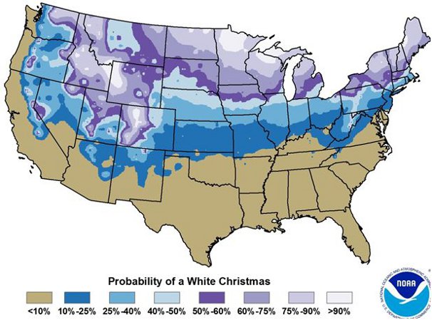
The statistical odds of a white Christmas in the cities? 72 percent. It may be a close call this year.
Historical Chances Of A White Christmas. In theory,
the force (and odds) are with us, although the statistical odds vary
greatly from north to south across Minnesota. Here are more details from
the
Minnesota Climatology Working Group: "
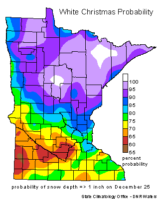
Will
we have a white Christmas? It's an age-old question that occurs to
almost everyone this time of year. The chances of having a white
Christmas vary even here in Minnesota. Having a white Christmas is
loosely defined as having 1 inch of snow on the ground on Christmas Day.
The snow depth at most sites is measured once a day, usually in the
morning. The best chances of having a white Christmas is almost
guaranteed in the Boundary Waters Canoe Area and a good part of the
Arrowhead. The chances decrease to the south and west and the best
chance for a "brown" Christmas is in far southwest Minnesota where
chances are a little better than 60%. Northern Minnesota is one of the
few non-alpine climates in the US where a white Christmas is almost a
sure bet (U.S. White Christmas Probabilities).
In 110 years of snow depth measurements in Twin Cities, a white
Christmas happens about 72% of the time. From 1899 to 2009 there have
been 31 years with either a "zero" or a "trace." The last time the Twin
Cities has seen a brown Christmas was 2006. The deepest snow cover on
December 25th was in 1983 with a hefty 20 inches. It was also a very
cold Christmas in 1983, with the high temperature of 1 measly degree F.
It was not the coldest Christmas Day in the Twin Cities. That dubious
award goes to 1996 with a "high" temperature of 9 below zero F. The
warmest Christmas Day in the Twin Cities was 51 degrees in 1922. There
was not a white Christmas that year. In fact, the Minneapolis Weather
Bureau log book for that day states that the day felt "spring like."
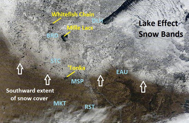
Snow Cover From Space. NASA's 1,000 meter "MODIS"
satellite image from midday Monday, under a mostly clear sky, shows snow
on the ground over the northern suburbs of the Twin Cities, from north
of Lake Minnetonka into Anoka county. There's still 1" in St. Cloud
northward to Brainerd. Downwind of Lake Superior you can see lake effect
snow bands over northern Wisconsin and the U.P. of Michigan, where 1-2
feet of snow has fallen since last Thursday.
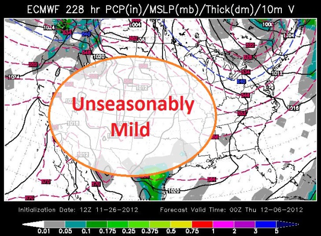
Mild Start To December. The map above (ECMWF) is
valid next Thursday, December 6, showing a persistent ridge of warm high
pressure from the Plains into the Rockies, temperatures 15-30 F. above
average. No major storms are expected looking out 1-2 weeks. We may
still get our white Christmas, but if it happens it will probably come
in the latter half of next month. Map above: WSI.
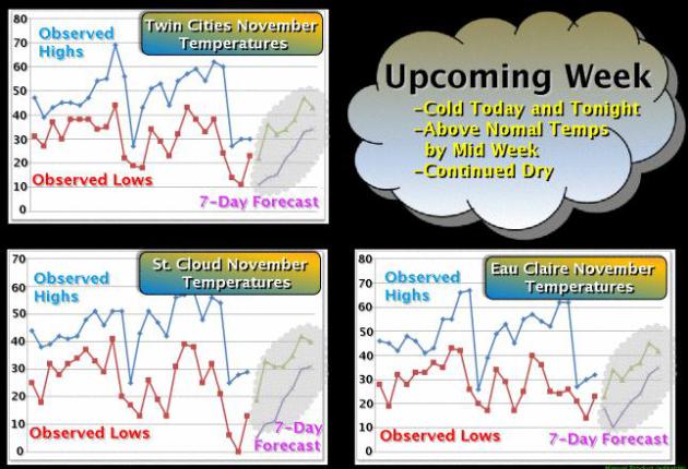
The Big Dip. Was it really 60 F. on Thanksgiving?
I vaguely remember that, before a healthy dose of winter arrived. This
is about as cold as it's going to be, looking out the next 10-14 days.
Graphic above courtesy of the local
Twin Cities National Weather Service.
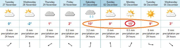
December Has Been Postponed. I'm sure we'll pay a
price for this mild spell in mid or late December, but there's now
little doubt that December, the start of meteorological winter, will get
off to a mild start. ECMWF models (above) for the Twin Cities show a
little rain Saturday, highs in the upper 40s to near 50. Even milder
weather surges northward next Monday; highs in the mid 50s to near 60.
Yes, it's possible we may see one more day of 60-degree warmth. Amazing.
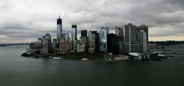
New York City Flood Protection Won't Be Easy. Here's an excerpt of a story from AP and
U.S. News and World Report: "
Inside
tunnels threading under a Houston medical campus, 100 submarine doors
stand ready to block invading floodwaters. Before commuters in Bangkok
can head down into the city's subways, they must first climb three feet
of stairs to raised entrances, equipped with flood gates. In
Washington, D.C., managers of a retail and apartment complex need just
two hours to activate steel walls designed to hold back as much as a
17-foot rise in the Potomac River. If metropolitan New York is going to
defend itself from surges like the one that overwhelmed the region
during Superstorm Sandy, decision makers can start by studying how
others have fought the threat of fast-rising water. And they must
accept an unsettling reality: Limiting the damage caused by flooding
will likely demand numerous changes, large and small, and yet even
substantial protections will be far from absolute..."
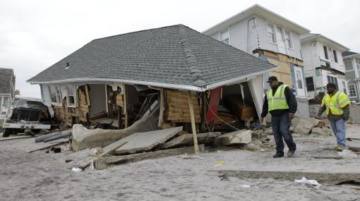
Photo credit above: "
In this Monday, Nov. 19, 2012 file
photo, utility workers walk past a badly damaged house in the Belle
Harbor neighborhood of the Rockaways, in New York. The house is one of
200 homes that has been designated unsafe by the New York City
Department of Buildings because of damage from Superstorm Sandy. Sandy
ran up a $42 billion bill on New York and the state and New York City
are making big requests for disaster aid from the federal government,
according to one of Gov. Andrew Cuomo's administration officials." (AP Photo/Kathy Willens, File)
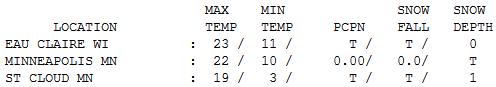
"Cold Enough". At least the sun was out (as it tends
to be on the colder days of winter - one benefit of chilly, Canadian
air: it tends to be accompanied by low humidity). Under a bright,
ineffective sun highs ranged from 17 at Alexandria to 19 St. Cloud (1"
snow left) to 23 in the Twin Cities and Redwood Falls.
Minnesota Weather History on November 26. Information courtesy of the
Twin Cities NWS.
2005: In the early morning a home in Mower County was hit by lightning and burned to the ground, but no one was injured.
1994: A low pressure system had
developed into the first Winter storm for Minnesota. By the early
morning hours of the 28th, a swath of snow in excess of 6 inches had
blanketed much of southwest through central into northeast Minnesota.
Snowfalls of 6 inches or more occurred south of a line from Gunflint
Lake in Cook county to near Ortonville in Big Stone county and along
and north of a line from near Blue Earth in Faribault county to Red
Wing in Goodhue county. The snow closed the Minneapolis-St. Paul
International Airport for a short time on the 27th, and contributed to
hundreds of accidents and at least three fatalities. In addition, the
build-up of ice and snow in combination with strong winds resulted in
numerous downed power lines in southeast Minnesota.
1985: Cold hits northern Minnesota. 30 below zero at Crookston.
1971: Heavy snows in the Southwest. Redwood Falls gets a foot.
Paul's Conservation Minnesota Outlook for the Twin Cities and all of Minnesota:
TODAY: Partly sunny, more tolerable. Winds: SW 10-15. High: 33
TUESDAY NIGHT: Clear to partly cloudy and cold. Low: 16
WEDNESDAY: Plenty of sun, still chilly. High: 29
THURSDAY: Patchy clouds, still quiet. Low: 20. High: 32
FRIDAY: Dim sun, not as cold. Low: 24. High: 38
SATURDAY: Clouds increase, PM rain showers possible. Low: 31. High: 48
SUNDAY: Sun returns, temperatures still well above average. Low: 33. High: 49
MONDAY: Mostly cloudy and unseasonably mild. Low: 36. High: 56
* temperatures cool off slightly next Tuesday, but then warm into the
40s, possibly even some 50s again the latter half of next week.
Climate Stories...
Climate Change Will Make Some Companies Extremely Rich - But Which Ones? Adapting
to a warmer, stormier climate, and mitigating the worst impacts, are a
threat, and one of the largest marketplace opportunities we've ever
witnessed.
The Atlantic does a good job of highlighting this - here's an excerpt: "
Large-scale
mayhem has produced some of history's great fortunes: war, for
example, but also the disruptive industrial, digital and--more
recently--financial revolutions: A lot of people have become rich,
others ruined....In terms of specific bets, the business of
"adaptation" (another climate buzzword) will boom. The biggest windfall
seems likely in the second half of the century, but there could be
plenty of business before then. Infrastructure would be particularly
big. That would include new facilities protected for extreme weather,
and retro-fitting existing structures and buildings against storms,
rising water and floods, and extreme heat and cold, suggests the Mercer
report...."
Photo credit: AP Photo/Mark Lennihan
When It Comes To Sea Level Rise, Conservatism Is (Unrealistic) Optimism.
There have been a flurry of stories in the wake of Sandy, explaining
the combination of warming, expanding, rising sea level and the
implications for coastal residents. Are these projections too
conservative? Here's an excerpt of a post at
getenergysmartnow.com: "
- This does not seem to include many complexities, such as land subsidence in, for example, the Chesapeake Bay area that are interacting with rising seas to hasten the impact on land areas.
- It seems to apply solely the global average sea-level rise around land levels rather than accounting for regional variations in sea-level rise. This matters, significantly, for the New York Times subscriber base as the East Coast of the United States is seeing and will see a larger sea-level rise than that global average.
- This does not address ‘underground’ issues, such as
saltwater intrusion on acquifers (which create serious problems for
Eastern Shore agriculture well before land goes under the ocean) or the
threat to infrastructure like sewer systems in port areas.
- There isn’t any representation of how storm surge impacts change with rising seas (re Norfolk, VA, area). These graphics demonstrate what will be covered but not necessarily what will become exposed to storm surges...."
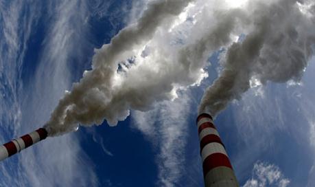
How The Myth Of Oil Abundance Impedes Progress on Climate Change. Here's a snippet of a story at
The Christian Science Monitor: "
The
great fear among those working to address climate change is that the
seemingly vast resources of fossil fuels waiting to be burned will send
the world hurtling toward certain catastrophe. By invoking fossil fuel
abundance, climate activists believe that their argument for a rapid
transition to alternative energy is made more persuasive. But, it is
poor strategy to reinforce the myth of fossil fuel abundance when doing
so actually makes many people less open to such an argument. And, as it
turns out, the abundance argument is also contrary to the available
data, logic and prudent risk management principles...."
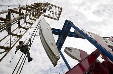
Photo credit above: "
In this July 2011 file photo, Ben
Shaw hangs from an oil derrick outside of Williston, N.D. Simple logic
and prudent risk management suggests that we should already be making a
rapid transition to renewable energy, Cobb writes." Gregory Bull/AP/File
The Private Sector Must Lead The Way On Climate Change.
Since politicians are dragging their feet, it's good to see that many
companies understand the long-term threats (and opportunities) posed by a
changing climate. Here's an excerpt of a story at
The Guardian's Sustainable Business Blog: "
When the Qatari sands run out at end of the Doha meeting which starts today with the aim of extending the Kyoto protocol on climate change,
we should not expect meaningful gains for the climate nor for
business. The actions of regulators and policymakers to reduce global
greenhouse gas emissions are fragmented, confused, ineffective and
weighed down by past mistakes. The chances of governments taking
effective action is bleak, so business needs to continue to lead the
way – and champion the message that the path to a low-carbon economy
lies in strategic market investment, not simply in reducing emissions
within their own boundaries..."
Photo credit above: "
With so many issues to fix, the Doha climate summit is unlikely to deliver much for business or the climate." Photograph: Peter Andrews/Reuters

No comments:
Post a Comment