30 F. high on Sunday in the Twin Cities.
36 F. average high for November 25.
54 F. high on November 25, 2011.
-18 F. record low for November 25 (1880)
62 F. record high for November 25 (1914)
Grumpy Old Men
Minnesotans like to share weather stories with
me. Go figure. During Saturday's Gophers game: "Paul, I live in
Chisholm. The last few winters snowmobilers have been detouring to
Michigan's U.P. for guaranteed lake effect snow. Will this winter be any
better?"
My wife calls it a methadone clinic for Yuppies,
but Caribou is my little oasis of caffeintated tranquility. Sunday:
"Paul, my husband and I distictly remember the scene in "Gumpy Old Men"
with Minnesotans ice fishing around Thanksgiving. That hasn't happened
in the 18 years we've lived here. What's up with that?"
Everyone has a story, anecdote or gripe. Weather is a contact sport and Mother Nature is the referee.
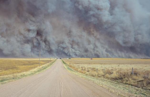
96 percent of Minnesota is in moderate drought
or worse, up from 36 percent in late August. Droughts are resilient
things - hard to break out of, especially in winter, when frozen ground
prevents moisture from sinking into topsoil.
Today will be about as cold as it's going to
get; a stubborn storm in the Gulf of Alaska keeping much of the USA
unseasonably mild into mid December. We thaw out by Thursday; a little
rain arrives Saturday with highs near 50.
A friend summed it up best: "we're limping into winter".
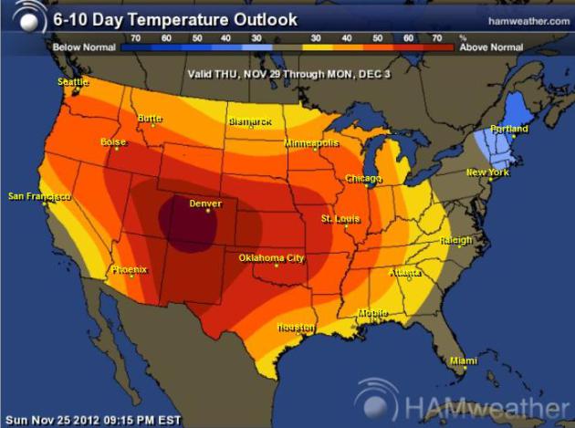
Imminent Thaw - 50s in December? Today there will be
NO doubt in your mind that meteorological winter starts December 1.
None. But a milder spell is right around the bend; a series of vigorous
Pacific storms keeping winds over the Lower 48 States blowing from the
west to southwest, meaning temperatures well above average from late
this week into at least the first week of December. Map: NOAA CPC and
Ham Weather.
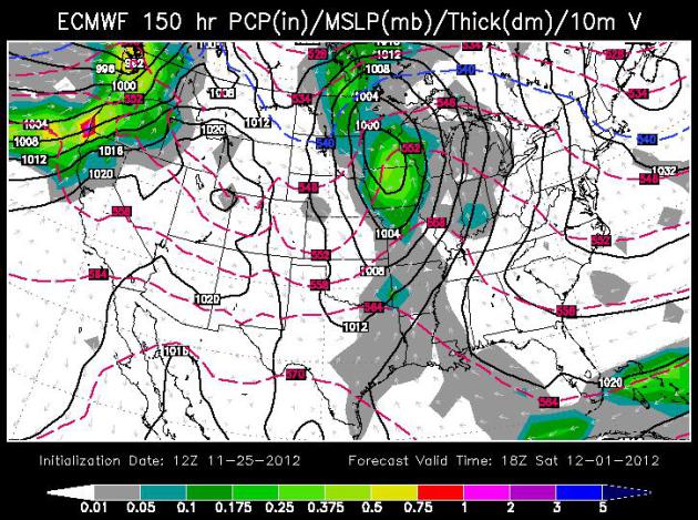
Rain - On December 1? The latest ECMWF (European)
model shows a surge of light to moderate rain spreading across Minnesota
Saturday, temperatures aloft (lowest mile of the atmosphere) well above
freezing - warm enough for rain. The blue dashed line in the Dakotas is
the "540 line", the approximate rain-snow line. Map: WSI.
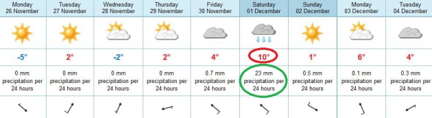
Gradual Thaw. Today will be plenty cold, low 20s for
"highs", but at least the sun should be out much of the day, no small
feat considering November and December are the two cloudiest months of
the year, on average. Another (weaker) clipper arrives Wednesday, and
then we begin to thaw out; 40s by Friday, a chance of sampling 50 by
Saturday (best chance of rain in sight). I have a hunch we may see one
or two more days next week near or above 50. ECMWF predicted highs (red
and blue) in Celsius.
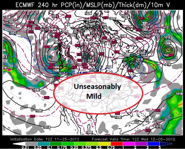
What December? Who knows what the latter half of
December will bring, but there's little doubt now that much of the USA
will get off to an unusually mild start to the month. A persistent
Alaskan low pressure system will keep the western states stormy,
counterclockwise winds pumping unusually mild air from the Pacific Ocean
and Gulf of Mexico east of the Rockies. I don't see any more bitter air
until mid-December (at the earliest). Map above: WSI.
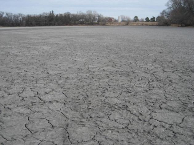
Paul,
I am a longtime reader of your blog. Thought you would be interested to
see these pics I took while visiting my parents for Thanksgiving down
in SW Minnesota outside of Fulda. Where I am standing usually has 4
feet of water. The drought down in that area is as bad as I have seen.
Anyway, keep up the blog!
Tom Braun
Plymouth, MN
Thanks
Tom - your photo sums up the drought better than any map I could
possibly dig up. All of southwestern Minnesota is in extreme drought
right now, with little improvement in sight. Once the ground freezes up
(next week's thaw may delay a hard freeze until mid-December) moisture
can't sink into topsoil, where it's needed. That's a problem. Right now I don't see any potential for improvement in Minnesota's drought until early 2013.
Historically,
in Minnesota, what is the coldest week of winter? While you are at it,
could you please tell us the coldest day as well? Thank you so very
much!
Carol Haakinson
Carol - historically the third week of January is
the coldest of the year. If I had to pick a day (which is kind of a
joke, a statistical average) it would be the 17th of January.
Temperatures bottom out in late January, and then start to recover by
Feb 1 or so. Photo above: AP.
Drought Update. According to
NOAA's Drought Monitor,
96% of Minnesota is in moderate drought (or worse), up from 36% in late
August. A quarter of the state is in extreme drought, a far cry from
August 21, when less than 1% of the state was in the extreme category.
The concern: once the ground freezes solid (we're close) any rain or
melted snow will run off into streams and storm sewers before having a
chance to soak into topsoil, where it's needed.
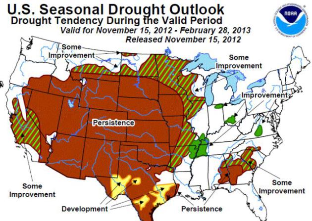
Drought Outlook. NOAA's
drought forecast
thru the end of February shows "persistence" across southwestern
Minnesota (meaning no improvement in the drought). Some improvement is
predicted for the rest of Minnesota, but we may have to wait until late
winter, early spring, for the shift in the pattern necessary to put a
serious dent in the drought.
Hurricane Sandy: New Jersey Rebuilding Ahead of Thoughtful Decisions? Here's a clip from
Huffington Post: "...
With
rising sea levels and more frequent major storms, it's time to
consider whether to rebuild in especially vulnerable areas and to look
at further strengthening building codes for places that are rebuilt,
scientists and environmentalists say. Similar debates have taken place
after major storms on the Gulf Coast, Florida and elsewhere. And they're
going on now on New York's Long Island...."
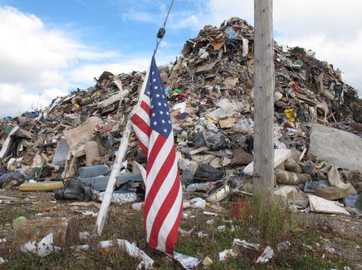
Photo credit above: "An American flag
blows in the breeze in front of one of the largest pils of storm debris
at the Jersey shore in Long Branch N.J. in this Nov. 15, 2012 photo.
Superstorm Sandy created tons of debris that towns in New York and New
Jersey are still struggling to dispose of weeks later. Three weeks in,
the round-the clock effort to remove storm rubble has strained the
resources of sanitation departments and landfill operators, and caused
heartaches and headaches for thousands of families." (AP Photo/Wayne Parry)
What Could Disappear.
The New York Times
teamed up with Climate Central and USGS to create an interactive map
that shows how coastal U.S. cities would be impacted by rising sea
levels: "
Maps show coastal and low-lying areas that would be
permanently flooded, without engineered protection, in three levels of
higher seas. Percentages are the portion of dry, habitable land within
the city limits of places listed that would be permanently submerged."
Those Bugs "Are Going To Outsmart Us". Yes, we have enough to worry about, but in case you missed this important story at
The Star Tribune about how crops are becoming increasingly bug and pest-resistant, it's worth a read. Here's an excerpt: "...
It
is what scientists and environmentalists regard as one of nature's
great ironies: Fifteen years ago, genetically engineered seeds promised
to reduce the amount of poisons used on the land, but today they are
forcing farmers to use more -- and sometimes more toxic -- chemicals to
protect their crops. Why? Because pests have done what nature always
does -- adapt. Just as some bacteria have become resistant to
antibiotic drugs, a growing number of superweeds and superbugs in the
nation's farm fields are proving invulnerable to the tons of pesticides
that go hand in hand with genetically modified seeds..."
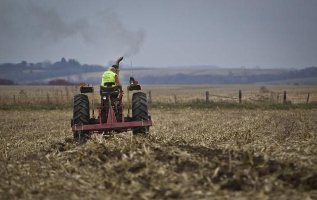
Photo credit above: "
Danny Serfling tilled a field on his
farm in Preston, Minn., in late October. He lost part of this field
and a whole other one to rootworm. The solution? “We will have to use
more insecticide,” he said." Renee Jones Schneider, Star Tribune.
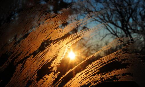
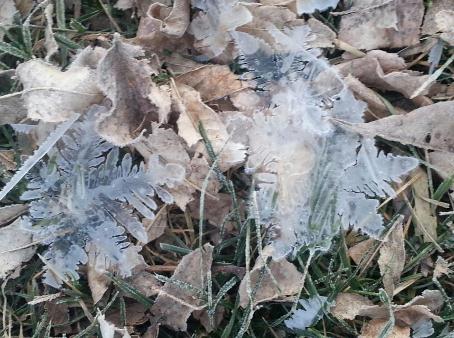
Mega-Flakes. I don't think I've ever seen anything
like this - and frankly, I don't have a good explanation. Anyone out
there have a clue what this is? Details via KARE-11: "
Thank you Jody
T. from Lonsdale for sharing this great picture! Jody says he saw
these giant frost flakes in his yard this morning."
Where's The Snow? As of Friday, November 23rd,
Milwaukee has gone 264 days since the last day with measurable snow,
which is the 4th longest streak on record. The last time Milwaukee had
measurable snow was on March 4, 2012, when 0.9 inch was measured.
Only a trace of snow is expected today with no snow expected on
Sunday. Hence the current streak should climb to 3rd place this
weekend. Source: NOAA.
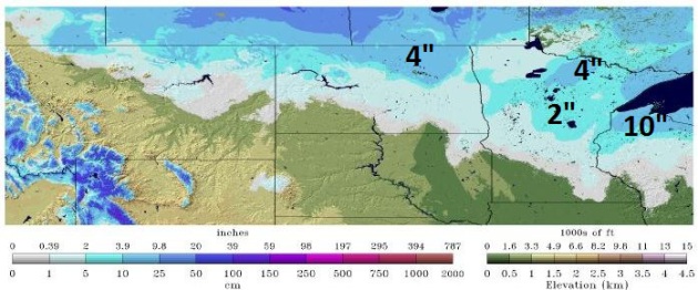
* snowcover map above courtesy of NOAA's
National Snow Analysis,
showing 2" on the ground from St. Cloud to Brainerd, as much as 4" near
International Falls. My friend in Herbster, Wisconsin reports 10-12" of
new (lake effect) snow in his yard.
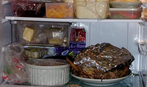
The Economics Of Wasted Leftovers. The statistics are daunting, according to this story from American Public Media's "
Marketplace"; here's an excerpt of an eye-opening story: "...
The Natural Resources Defense Council
estimates that Americans trash 40 percent of our entire food supply.
For a family of four, that works out to more than $2,000 a year. Dana
Gunders is a food project scientist at NRDC. She puts the numbers in
perspective. “Imagine going to the grocery store, buying three bags of
groceries, dropping one in the parking lot, and not bothering to pick
it up," she says. "That’s essentially what we’re doing in our food
system today." Gunders is talking about all the food we waste. From
veggies left to rot in the fields because they’re not exactly the right
shapet to uneaten food on restaurant plates. And, of course, forgotten
leftovers that morph into something monstrous in the refrigerator..."
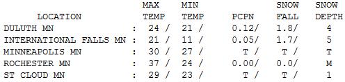
Feels like December. No, it won't stay this chilly
for long, in fact we're 72 hour away from the start of a gradual thaw,
one that may spill over into the first week, possibly the first half of
December. Under a persistent cloud deck highs were stuck in the 20s and
low 30s Sunday, ranging from 21 at International Falls (5" snow on the
ground) to 29 at St. Cloud (1 inch left) to 30 in the Twin Cities (trace
of snow), to 34 at Redwood Falls.
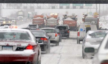
Major Weather Events on November 25 - courtesy of the
Twin Cities National Weather Service:
2001: A strong low pressure
system developed in Colorado on the 25th, reached eastern Iowa during
the evening of the 26th, then moved into eastern Wisconsin late on the
27th. It produced a wide swath of heavy snow across much of central
Minnesota into West Central Wisconsin. Storm total snowfall of 8 inches
or more was common, with a large area exceeding 20 inches.
Specifically, Willmar picked up 30.4 inches, New London saw 28.5
inches, Collegeville had 23.4 inches, Litchfield and Granite Falls
received 22 inches, 14 inches at Canby, 10.7 inches at Springfield, 11
inches at Long Prairie, 12.5 inches at New Hope, 15 inches at Milaca,
11 inches at Wild River State Park, and Milan had 20 inches. A
convective snow band set up across this area on the 27th and remained
nearly stationary for over 12 hours, resulting in the extreme storm
totals. From 8 am on the 26th to 8 am on the 27th, Willmar received 21
of its 30.4 inches, setting a record for most snowfall in Willmar in a
24 hour period. Visibilities were frequently below 1/4 mile during the
storm, and winds remained in the 15 to 30 mph category. The heavy wet
snow downed numerous power lines, and at one point, at least 20,000
customers were without power in the Minneapolis-St. Paul metropolitan
area. Over one thousand traffic accidents were noted across the entire
area. Most were minor, but one accident claimed two lives when a car
spun out and collided with a semi near Mora.
1995: A narrow band of five to
eight inches of snow fell from west central Minnesota around Canby and
Granite Falls to east central Minnesota. This included much of the Twin
Cities metro area.
1965: Snowstorm across northern Minnesota. 14.7 inches of snow fell at Duluth, and 13.6 inches at Grand Rapids.
1896: Severe Thanksgiving day
ice storm over southwest and central Minnesota. 1.42 inches of rain at
Bird Island and 1.20 inches of rain at Montevideo. The ice caused a
great deal of damage to trees and shrubs.
Paul's Conservation Minnesota Outlook for the Twin Cities and all of Minnesota:
TODAY: Blue sky - coldest day in sight. Winds: NW 10. High: near 20
MONDAY NIGHT: Mostly clear, still cold. Low: 14
TUESDAY: Clouds increase, not as cold. High: 34
WEDNESDAY: Intervals of sun, brisk. Low: 13. High: 28
THURSDAY: Partly sunny, chance of a thaw. Low: 18. High: 35
FRIDAY: More clouds, probably dry. Low: 26. High: 38
SATURDAY: Rain arrives. On December 1. Low: 31. High: 49
SUNDAY: Gray start, slow PM clearing. Low: 29. High: 39
* more 40s are likely next week, maybe a few days at or above 50 F.
Climate Stories....
Global Warming Changes Gardening Tactics. Here's an excerpt of an informative article on the impacts of a warming climate on gardening from
myrtlebeachonline.com: "...
The
warming climate will result in a longer growing season which will give
rise to new insect pests and more life cycles from our current foes.
New weeds will invade our gardens. Drought and heat will increase the
need to water. Wet weather will increase fungal diseases.
Predictability will tenuous. What is a gardener to do? Plant for the
future and follow good gardening practices.
• Choose drought-tolerant plants. Research a plant’s
requirements before you buy. The wider the range of conditions a plant
tolerates, the better it will perform in the future.
• Use microclimates in your yard for more than winter cold
protection. Find areas that provide afternoon shade to shelter plants
from summer heat and sun. Keep in mind that shady areas in winter may
be sunny in summer and vice versa..."
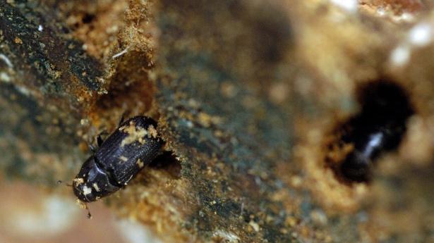
Pine Beetles Contributing To Climate Change, Study Says.
An estimated 20% of British Columbia's forests have been impacted by
pine beetles - millions of dead trees contributing to a warmer climate
over western Canada. Canada's
CTV News has the story.
Photo credit: "
A mountain pine beetle crawls out of a
ponderosa pine tree while another, right, remains in its hole in Green
Mountain Falls, Colorado, August 24, 2005." (The Gazette, Hunter McRae).
Read more here: http://www.myrtlebeachonline.com/2012/11/24/3171767/gardening-global-warming-changes.html#storylink=cpy
"
The amount of greenhouse gases in the atmosphere reached a new
record high in 2011, according to the World Meteorological
Organization. Between 1990 and 2011 there was a 30% increase in
radiative forcing – the warming effect on our climate – because of
carbon dioxide (CO2) and other heat-trapping long-lived gases." - WMO, the World Meteorological Organization. Source
here.
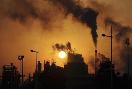
Scientists Say Freakish Weather Could Become The Norm Due To Global Warming. Here's an excerpt from a story at
The New York Daily News: "
The
U.S. was blasted by monster storms and scorched by record heat waves in
2012 - freakish weather that could become more commonplace because of
global warming, scientists warn. But climate activists hope the
destructive weather could have a side benefit of forcing President Obama
off the bench when it comes to to the issue of climate change..."
Photo credit above: AP/Tony Rayle/Yuma Sun
Fight Against Climate Change Blocked By Luddites At Big Oil: McQuaig. Here's a clip from
thestar.com: "...
The
news on the climate front is devastating. In a report earlier this
month, PricewaterhouseCoopers (PwC), one of the world’s largest
accounting firms, states the world has “passed the critical threshold”
and that current carbon reductions amount to “a fraction of what is
required against the international commitment to limit global warming
to 2 degrees Celsius.” In order to keep within that limit by 2050, the
accounting firm says the world will have to dramatically accelerate its
annual pace of carbon reduction — to a rate never before achieved, and
then continue at that rate “for 39 consecutive years.” No problem!
That’s if we want to keep warming to just 2 degrees Celsius — which may
be too high. So far, we’ve warmed the planet by only 0.8 degrees
Celsius — and yet that little bit of warming packs quite a punch, as the
U.S. east coast learned last month..."
Photo credit:
Bruce Chambers/AP "Oil companies currently have proven reserves of oil, gas and coal worth $27 trillion."
Global Warming And The Emotional Divide. No one
wants to hear bad news. Believe me, I get that. Some days I feel like
Dr. Doom. After a correct call on Sandy, 7 days before landfall, one of
our corporate customers started referring to me as Nostradamus. Lovely.
But here's the thing: once you acknowledge the trends, the science, you
at least have a chance to adapt and mitigate, leveraging new
technologies (the market!) to make the problem better. We'll eventually
have to do just that, as a country (and planet), but some of us will be
dragged kicking and screaming (and denying the data) for a few more
years before we finally come to grips with a changing climate. And in
the process we may just reinvent our energy economy and set America on
the right course, competitively, for generations to come. Here's an
excerpt of an Op-Ed at
Madison County Journal that resonated: "...
So,
when global warming is brought up, I feel that same emotional click
inside. My first thought is, “shut up!” I want to put my fingers in my
ears. I think society generally shares that feeling. We don’t want to
hear it. But my gut is going hard the other way. And my gut doesn’t have
a “liberal” agenda unless it’s in front of a hot pizza. No, in fact, I
want the scientists who push global warming to be wrong. How could I
want anything else? It’s an awful prospect. And I certainly don’t want
future generations to face any such reality. But I get this sick feeling
these days about the weather. Beyond what scientists tell us, it feels
like it’s changing — and not for the better. And the
“nothing-to-see-here” mantra of global warming skeptics isn’t meshing
with that feeling I have watching these storms grow more and more
fierce, whether it’s spring tornadoes or fall hurricanes...."
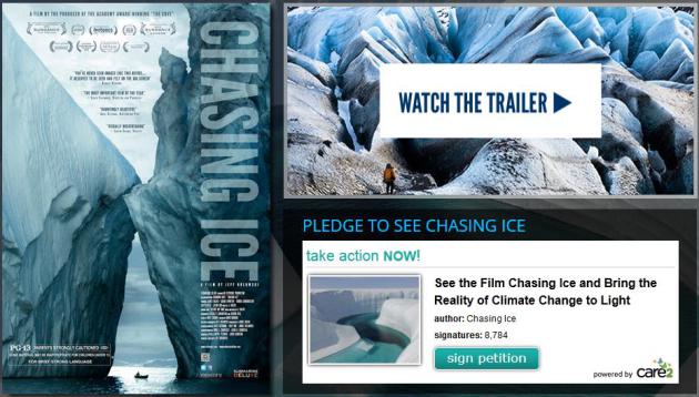
Chasing Ice: A New Documentary Melts a Climate Change Skeptic's Heart. I've heard reports that this is a remarkable movie - hoping it comes to Minnesota soon. Here is an excerpt from a
Huffington Post story: "...
Going
to the world's most remote places and taking photographs was second
nature to James Balog, who developed a career with assignments for
National Geographic and others. But he was a climate change skeptic.
"It was hard for me to believe that people could affect something so
vast as the whole planet," he said. But he has a 24-year-old and an
11-year-old daughter and "I want to offer them, in my own way, a better
future," he said. He worried that he wouldn't have a good answer for
them if climate change turned out to be true and they asked him "what
did you do to stop it?" He decided to couple his "privilege as an
artist," with "his duty as a human being" by documenting the changes
occurring to glaciers..."
* more on the documentary "Chasing Ice"
here.


No comments:
Post a Comment