Minor Setback
By Todd Nelson
The next 24 to 48 hours are going to be a little wild around
these parts. A strong Pacific low has found its way into our neck of the
woods with a modified batch of Arctic air lurking just behind it. This
colder air will help to turn any moisture on the northwestern flank of
the storm into a big pile of wind-whipped snow.
Some of that wintry weather may make an appearance in your
back yard by the second half of the weekend, but the impacts will be
nearly nonexistent compared to what is expected across Montana and North
Dakota. Folks there will dig out from nearly a foot of fresh snow.
Winter weather headlines have been posted as close to us as
the far northern reaches of Minnesota, but warm air surging north will
have some of the precipitation in the form of sleet and freezing rain;
snow amounts minimized. We stay in the warm sector today with a little
rain and perhaps even a few afternoon rumbles of thunder. A few more
vigorous storms could fire up just to our south as the cold front blasts
through
Heavy jackets return as character building cold arrives on
Sunday. I expect our coldest day since early March on Monday; 50s return
late next week? -Todd Nelson
_________________________________________________________________________
Todd's CONSERVATION MN Outlook for the Twin Cities and all of Minnesota (and western Wisconsin too):
SATURDAY: Light rain in the morning with a wintry mix lifting
through northern MN. Spotty showers possible later with a growing
afternoon/evening thunder potential across the southeastern part of the
state. The Twin Cities may even hear a few rumbles of thunder. High 60.
SATURDAY NIGHT: Isolated thunderstorm, scattered showers. Breezy and turning colder. Low: 40.
SUNDAY: Breezy and much cooler! Chance of a little wintry mix
in the morning, then a few flurries possible in the afternoon,
especially across far northern MN. High 40 (temps falling). Low 23.
MONDAY: Lingering clouds and perhaps even a few passing flurries, mainly across northern MN. Increasing sunshine late. Coldest day since early March. High: 31. Low: 20.
TUESDAY: Jacket worthy. Chilly sunshine, feeling like late November. High: 37. Low: 25.
WEDNESDAY: A little warmer, near average temperatures return. High: 43. Low: 31.
THURSDAY: Still quiet, no major storms. High: 48. Low: 32.
FRIDAY: 50s return? More mild sunshine. High: 50. Low: 34.
_________________________________________________________________________
Saturday, November 10th, 2012
Our next major storm continues to wrap up
over the mid-section of the nation. Heavy snow on its northwest flank
and a chance of strong to severe storms on its warmer, more unstable
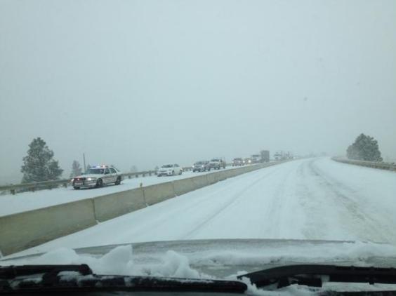
southeast flank later Saturday. Thanks to @MTGjh for the picture below
out of Montana, where driving conditions were quite hazardous on
Friday. Unfortunately, I don't see them getting much better on Saturday.
In fact, driving conditions will worsen for a number of other folks as
the major winter storm expands east through the High Plains. For folks
that live in colder climates, the image below probably isn't all that
uncommon and I'm sure there are several people that aren't too excited
about winter weather returning in the not too distant future.
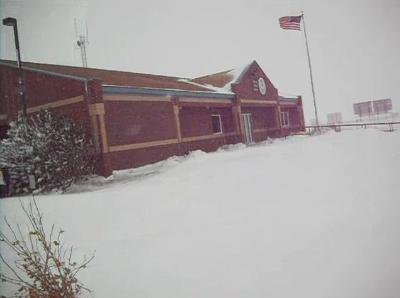
Over a Foot in Great Falls, MT
Thanks to the National Weather Service out of Great Falls, MT for the info below:
"Over a foot of snow has fallen since
Thursday morning at the NWS forecast office in Great Falls. Breezy north
winds have been blowing and drifting the snow this afternoon."
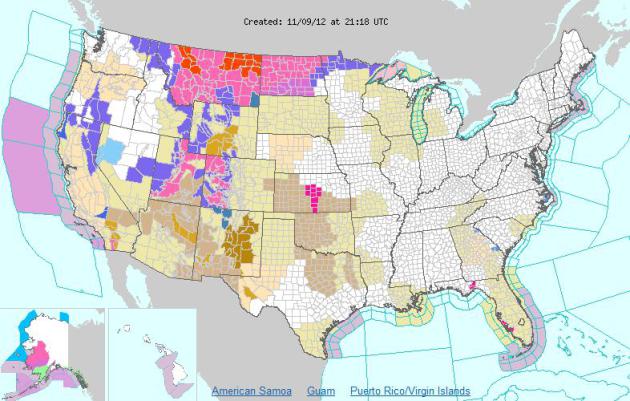
Several Weather Headlines
The map below is fairly impressive. These
are all the weather headlines that have been posted by various National
Weather Service sites across the nation. Note how the map is quite a
bit more lit up in the west due to a strong Pacific storm moving into
the mid-section of the nation. Also note how things have quieted down,
thankfully, across the eastern part of the country. Folks out there need
SEVERAL quite days (or more) to get their feet back under them!
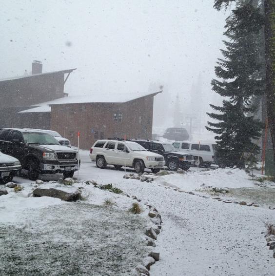
Mountain Snow
Not only are the High Plains getting
snow, but this large storm is spreading the weath to those in Utah,
Colorado and California! Thanks to Sugar Bowl Resort in Norden, CA for
the picture below where opening day is only a few short weeks away! This
latest snow will certainly help out for their December 12th projected
open.
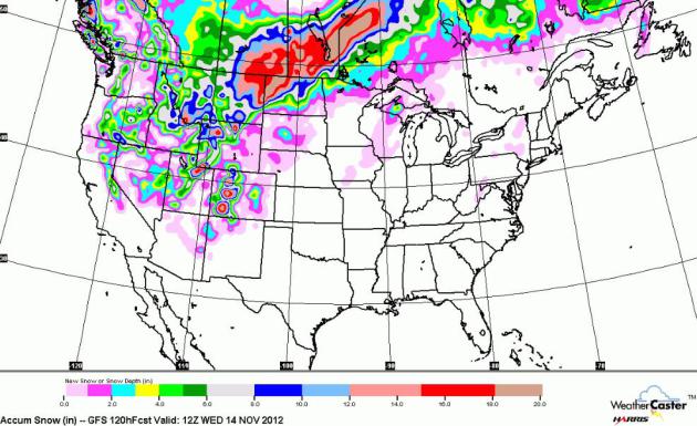
The Big Dump...
Large storms tend to not be disrupted as
much as weaker storms as they cross over the Rocky Mountains. Moisture
is plentiful even when the mountains gobble up their share. The GFS snow
solution suggests quite a dump across parts of Montana and North
Dakota.
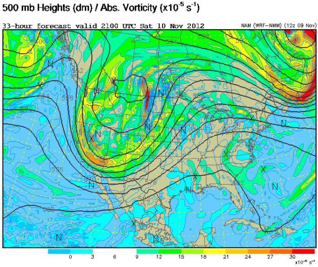
Large Pacific Storm
Just to give you an idea of what we're
dealing with here, take a look at the 500mb vorticity map below, which
shows how much spin there is in the atmosphere. That large "U" shape
across the western half of the country is the storm, the effects of
which will be felt as far south as Arizona and New Mexico!
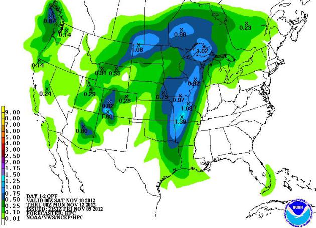
Weekend Precipitation
As the storm swings inland, precipitation
will hardly be sparse for a number of locations east of the Rockies.
I could see several spots picking up a much needed 1" to 2" of
precipitation through PM Sunday. Note the 'comma' shape to the
precipitation pattern. This is the sign of a large, well defined,
mid-latitude cyclone. These types of system also tend to tap Gulf of
Mexico moisture for enhanced rainfall/thunder potential across the
Plains.
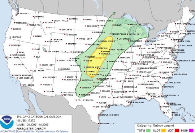
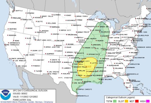
Weekend Severe Potential
Dynamic storms system, such as this one,
have a greater potential to create more wild weather. Because the
temperature difference across the front will be so great and because
it'll be able to tap enough moisture from the Gulf of Mexico, we may
have to watch out for a few strong to severe storms this weekend. The
Storm Prediction Center has issued a SLIGHT RISK of severe weather
Saturday and Sunday for areas shaded in yellow below. You might think
it's a little strange to see severe weather at this time of the year,
but in fact, we typically have a secondary severe weather season as
these types of system emerge. Dwindling daylight across the Arctic
regions has the cold air resivoir buidling rapidly and as the cold air
bulids, stronger storm systems develop in order to 'try' to distribute
this air south, in return sending warmer air north.
Saturday Severe Potential
Sunday Severe Potential
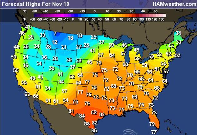
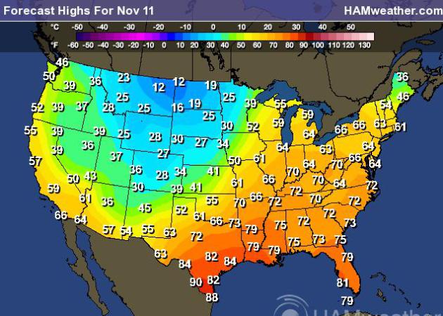
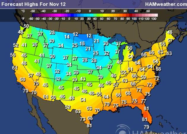
Big Temp Tumble
This front will likely bring some of the
coldest air of the season. For example: Minneapolis, MN will likely have
high temperatures on Monday around 30F - that will be the coldest
daytime high since early March!
Highs Saturday
Highs Sunday
Highs Monday
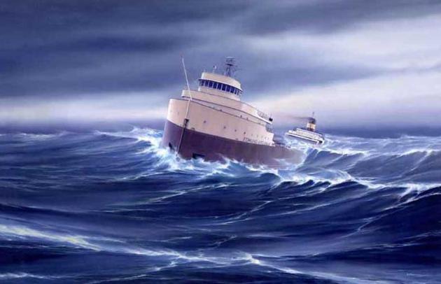
November 10th, 1975 - Edmund Fitzgerald Sinks on Lake Superior
Saturday in the anniversary of the
sinking of the Edmund Fitzerald in 1975. Interesting to note that we're
dealing with a fairly similar storm this weekend. Gale Warnings have
been posted for parts of Lake Superior this weekend!
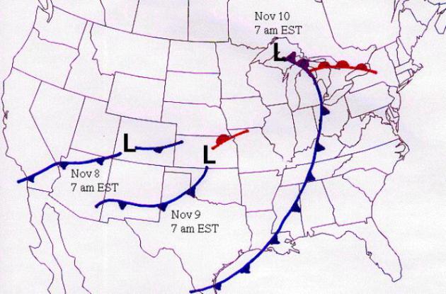
1975 Weather Map
On November 10,
1975 the SS Edmund Fitzgerald sank in Lake Superior. All 29 crew members
died. At the time, it was the worst shipping disaster on the Great
Lakes in 11 years. Other shipping disasters on the Great Lakes, in which
weather played a role include:
Nov. 11, 1913: eighteen ships were lost killing 254 people.
Nov. 11-13, 1940: 57 men died when three freighters sank in Lake Michigan.
Nov. 18 1958: 33 men died on Lake Michigan with the sinking of the Carl D. Bradley.
Nov. 29, 1966: Daniel J. Morrell sank in Lake Huron killing the 28 crew members.
Nov. 11-13, 1940: 57 men died when three freighters sank in Lake Michigan.
Nov. 18 1958: 33 men died on Lake Michigan with the sinking of the Carl D. Bradley.
Nov. 29, 1966: Daniel J. Morrell sank in Lake Huron killing the 28 crew members.
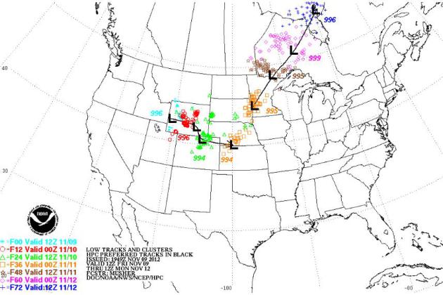
2012 Weather Map
This is the forecast track of the low
pressure system over the weekend from NOAA's HPC. It looks fairly
similar to that of 1975 weather map above, doesn't it?
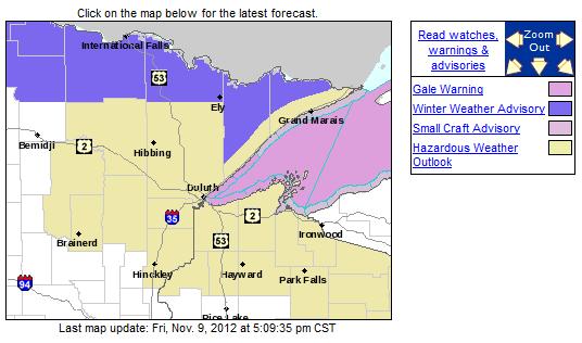
Lake Superior Gale Warnings
With the impending storm, the National
Weather Service has issued Gale Warnings for western Lake Superior.
Waves could be as high as 15ft with wind gusts to 40knots (46mph).
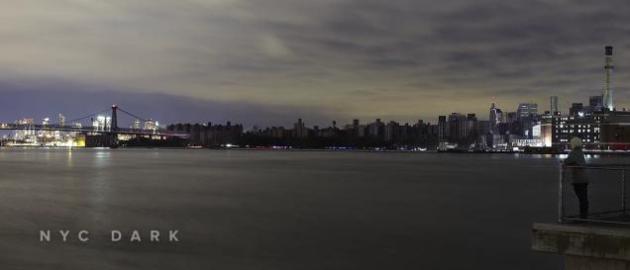
Spooky Timelapse of a Dark NYC
This is an interesting take from an NYC resident during the blackout that ensued during the events of Superstorm Sandy.
"It’s hard to describe a city in
complete darkness. The towering structures that are part of your
city-life moorings turn dark and ominous. It’s hard to say what that
feels like but, in the above video, Jared Levy sums up New York City’s
Superstorm Sandy blackout pointedly and with ease.
“I’m looking at something that should not be,” he says. “There was this instinctual urge to go into it.”"
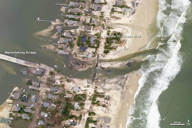
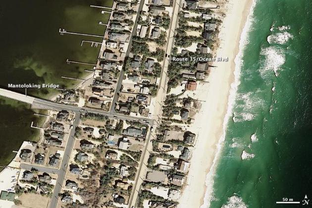
Before and After Superstorm Sandy
Take a look at these amazing images! My heart goes out to all the people that were affected by Superstorm Sandy.
"On October 29, 2012, lives were
changed forever along the shores of New Jersey, New York, Connecticut,
and in the two dozen United States affected by what meteorologists are
calling Superstorm Sandy. The landscape of the East Coast was also
changed, though no geologist would ever use the word “forever” when
referring to the shape of a barrier island."
Superstorm Sandy: AFTER
Superstorm Sandy: BEFORE
Thanks for checking in, have a great rest of your weekend!
Don't forget to follow me on Twitter @TNelsonWNTV

No comments:
Post a Comment