Thank you Veterans!
By Todd Nelson
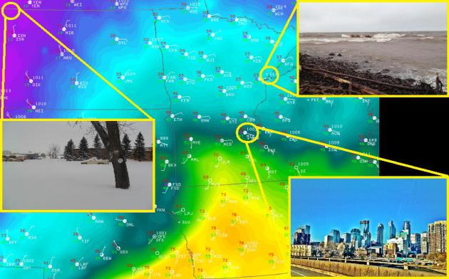
Our sunny, near 70F afternoon
(record high) in the Twin Cities on Saturday was a bit surreal.
Especially since we'll be almost 40F cooler on Sunday and Monday as a
powerful cold front blasts through. It'll be cold enough for a little
wintry precipitation today and tomorrow, but nowhere as significant as
the glaze ice and heavy snowfall (up to 18") that parts of North Dakota
saw Saturday.
As a meteorologist, these are the
types of storms that get me giddy. Put a weather nerd in front of a
computer screen that shows a storm system spitting out thunderstorms
with hail and heavy snow within a few hundred mile span and you've got
yourself a source of entertainment for hours!
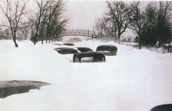
This is nearly the same type of
storm that sank the Edmund Fitzgerald on Nov. 10th, 1975 and claimed the
lives of 49 Minnesotans, many duck hunters, on Nov. 11th 1940. The
Armistice Day Blizzard was sudden and severe; 16.9" of snow in the Twin
Cities, 26.6" in Collegeville and 20ft. snow drifts in Willmar.
My Grandma recalls no one showed
for her birthday party that day in 1940 and her mom was lucky to make it
back from the chicken coup due to blinding snow in Brainerd. Happy
birthday Grandma! -Todd Nelson
______________________________________________________________________________________
Todd's CONSERVATION MN Outlook for the Twin Cities and all of Minnesota (and western Wisconsin too):
SUNDAY: Breezy and much cooler!
Chance of a little wintry mix, then a few flurries possible in the
afternoon, especially across far northern MN. High 39 (temps falling).
SUNDAY NIGHT: Mostly cloudy with a few passing flurries. Cold and breezy. Low: 20
MONDAY: Lingering clouds and perhaps even a few passing flurries, mainly across northern MN. Increasing sunshine late. Coldest day since early March. High: 31. Low: 20.
TUESDAY: Jacket worthy. Chilly sunshine, feeling like late November. High: 38. Low: 26.
WEDNESDAY: A little warmer, near average temperatures return. High: 44. Low: 31.
THURSDAY: Still quiet, no major storms. High: 46. Low: 32.
FRIDAY: 50s return? More for November. High: 47. Low: 32.
SATURDAY: Clouds return, still mild. High: 48. Low: 34
____________________________________________________________________________________
Sunday, November 11th, 2012
Thanks to a powerhouse Pacific stor, we had
some wild weather across the Upper Midwest yesterday. Here is a just a
sample of some of the extremes!
Crosby, ND: 18" of snow
Duluth, MN: 15ft. waves open water (10ft. near shore)
Minneapolis, MN: 69F record high at MSP Airport
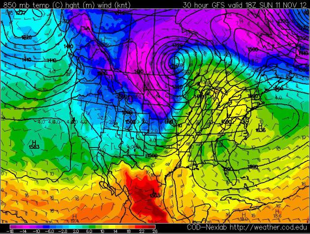
Large Pacific Storm
The big circular ball moving into southern
Canada is the storm that is causing all the problems. The large
temperature difference from north to south is what is helping to
intensify the storm even more.
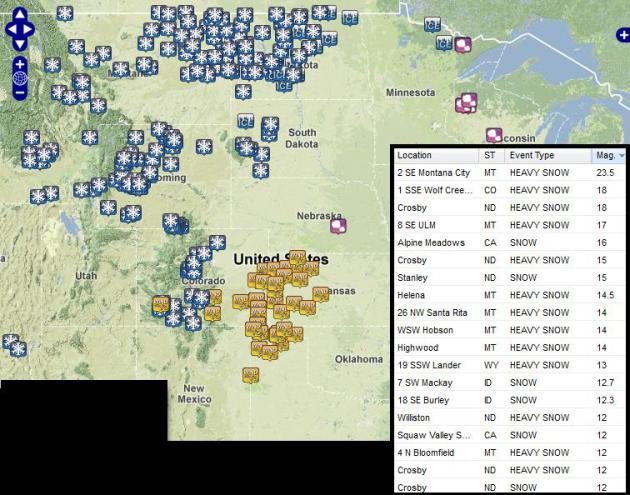
Highest Snow Tallies
For those on the NW side of the storm,
heavy snow tallies racked up to the tune of 1ft. to almost 2ft. - here
are some of the heaviest snow tallies reported east of the Rockies.
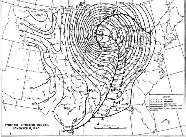
Wild November Storms
November is typically the time of year when
large storms gather strength across North America. Take a look at the
weather map from November 10th,1940! WOW, what a storm! This will be
remembered as the Armistice Day Blizzard of 1940:
"The blizzard that struck the Midwest
in November 1940 was the type of snow storm that engenders legends. Fall
was extremely mild and across the Upper Midwest temperatures were well
above normal on the morning of November 11th. So warm that at 7:30 in
the morning the temperature at Chicago was 55 degrees Fahrenheit, and at
Davenport Iowa the temperature was 54. Armistice Day 1940 was a perfect
opportunity for many individuals to enjoy the mild respite before
winter. Little did they know the most infamous duck hunt in American
history was about to unfold. When the storm exited the region over a
foot of snow had fallen, and more than 150 people and thousands of
livestock were dead."
Remembering the 1940 Armistice Day Blizzard
This is a great account from wildfowlmag.com during the Armistice Day Blizzard:
"Imagine, if possible, that day on the
waters of the Mississippi or a tributary, without today’s technology. No
outboard motor, no cell phone, no high-tech warm clothing, only a
man-powered wooden boat for transportation. Those hunters and fishermen
caught offshore did every
thing possible to keep from freezing to death. They burned decoys, blinds and even boats. In the end, 163 people perished, and many others were scarred for life."
thing possible to keep from freezing to death. They burned decoys, blinds and even boats. In the end, 163 people perished, and many others were scarred for life."
(“Armistice Day Blizzard” by Michael Sieve. artwork provided courtesy of the artist and Wild Wings. www.wildwings.com)

#2 on the Top 5 Weather Events of the 20th Century for Minnesota
"The Armistice Day Blizzard Ranks #2 on
the Minnesota State Climatology Office Top five weather events of the
20th century. Ask any Minnesotan born before 1940 and they can tell you
where they were during the Armistice Day Blizzard."
Big Temperature Tumble
This front will be responsible for a large
temperature tumble across the country. Temperatures will drop nearly 40F
in a few locations from where they were on Saturday.
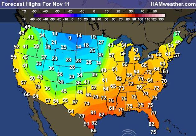
Highs Sunday
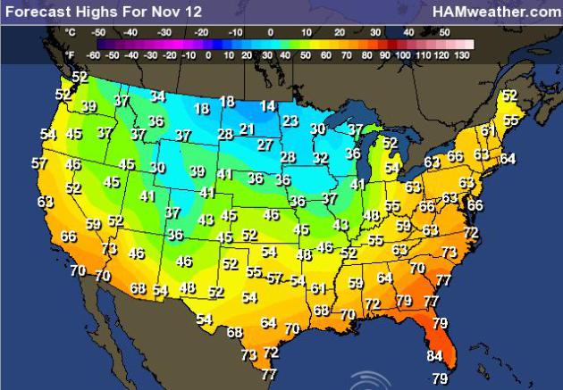
Highs Monday
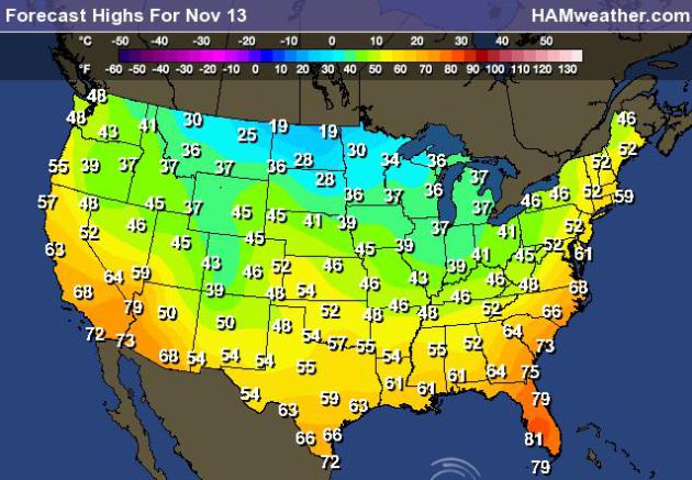
Highs Tuesday
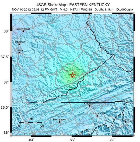
Kentucky Quake
Did you hear about the earthquake in
Kentucky on Saturday? The USGS says that a 4.3 magnitude quake hit the
area and was felt as far away as Georgia!
"A magnitude 4.3 earthquake struck
about eight miles west of Whitesburg, Ky., just after noon on Saturday,
the United States Geological Survey said. The epicenter of the
relatively light earthquake, which struck at a depth of 0.7 miles, was
in Blackey, Ky., the agency said. The town, which is in the Appalachian
Mountains, is near the border with Virginia and about 110 miles
southwest of Charleston, W. Va. Tremors were felt as far north as
Columbus, Ohio, and as far south as Atlanta, said Paul Caruso, a
geophysicist with the agency. He called the temblor “moderate” and said
that aftershocks were a possibility."
Predicting Presidents, Storms and Life by Computer
"WASHINGTON - Forget political pundits,
gut instincts, and psychics. The mightier-than-ever silicon chip seems
to reveal the future.
In just two weeks this fall, computer models displayed an impressive prediction prowess.It started when the first computer model alerted meteorologists to the pre-Halloween disaster headed for the Northeast from a bunch of clouds in the Caribbean. Nearly a week later, that weather system became Hurricane Sandy and grew into a superstorm after taking a once-in-a-century sharp turn into New Jersey."
Read more from Startribune.com HERE:
Thanks for checking in, have a great rest of your weekend!
Don't forget to follow me on Twitter @TNelsonWNTV

No comments:
Post a Comment