53 F. high in the Twin Cities Thursday.
41 F. average high for November 15.
51 F. high on November 15, 2011.
60 F. highs possible next Wednesday, and the Saturday after Thanksgiving.
Thanksgiving Weather: 46-51 F, patchy clouds behind a weak cool frontal passage, probably dry.
Good Travel Weather
"Unusual travel suggestions are dancing lessons
from God", wrote Bill Bryson - one of my favorite authors. I spent some
time in Nicaragua and Columbia earlier this month. Every American should
be forced to travel overseas. You come back to the USA with new eyes; a
new appreciation for what we have, what we often take for granted.
My nervous tick kicks in around Thanksgiving, a
time of year when building chill up north often conspires to spin up
big, beefy storms, just in time to complicate turkey dinner with
Grandma.
Not this year. For the next 1-2 weeks the
weather map will look like something out of mid-October. The jet stream
lifts north, meaning 50s - even a crack at 60 next Wednesday and the
Saturday after Thanksgiving.
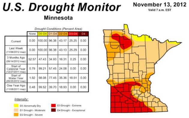
The latest Drought Monitor (below) shows most of the metro in severe drought; 100 percent of Minnesota is "abnormally dry".
Yesterday I witnessed smoke and smog from
brushfires casting a pall on the downtown skyline. We need rain, badly,
but a lack of arctic air will limit the ability for big storms to spin
up anytime soon. The drought signal is still too strong.
In today's blog: the local NWS has increased the number of small tornadoes last Saturday to 4! Details below.
A Stubborn Drought. 100% of Minnesota is now
classified as "abnormally dry", over 43% of the state in a severe
drought, including most of the Twin Cities metro. Extreme drought covers
most of southwestern Minnesota, extending into St. Cloud. The drought
signal is pervasive, and will probably spill over into the first half of
winter. Details from NOAA's
U.S. Drought Monitor.
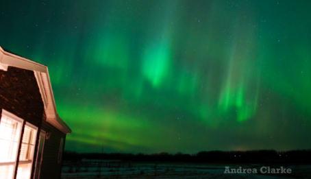
Aurora Watch. Thanks to
Andrea Clarke
in Saskatchewan for passing this along. The Northern Lights have been
very visible (and vivid) in recent nights - worth a look tonight, as
skies should be clear to partly cloudy.
And Then There Were Four. The local NWS office now
counts 4 small (EF-0) tornadoes last Saturday, as a vigorous cold front
plowed across the state. Doppler radar doesn't work nearly as well on
small, brief tornadoes that spin up along a squall line - a very
different scenario from classic (large) supercell thunderstorms, the
isolated cells that spawn big tornadoes well in advance of the cold
front during spring and summer. Here's
more from the NWS: "
There
were two tornadoes in this region (map) that occurred Saturday night,
November 10th. One was near Interstate 494 and Highway 13. The other
tornado occurred near Lilydale, between Wachlter and Butler Ave, or
paralleling Highway 13. Two areas of straight line wind damage occurred
from near Dodd Road and Highway 110, northeast to Robert Street and
Sidney Street; and along Highway 13, between Mendota and Lilydale. Both of the tornadoes had a path length of approximately one-half mile."
Misplaced Priorities. Maybe it's just me, but the
media's sudden obsession with "the Petreus affair" seems way off-base,
considering the carnage, heartache and loss on the east coast in the
wake of Sandy.
This web site
sums up the hypocrisy of leading with lurid tales of sex at high
levels, when hundreds of thousands of Americans are trying to put their
lives back together again. It's worth a look.
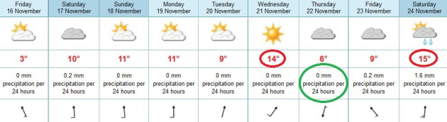
Not Bad For Late November. The pattern looking out
10 days would look right at home in mid-October. Jet stream steering
winds are lifting north into Canada, bottling bitter air many hundreds
of miles north of Minnesota until further notice. Temperatures will run
5-15 F. above average thru the last weekend of November; a shot at 60
next Wednesday, again the Saturday after Thanksgiving. A cooler front
may knock highs into the 40s next Thursday for turkey (and football)
consumption, but a 50-degree high is possible on "Black Friday". Power
shoppers lined up at Best Buy may only need a light jacket this year.
Here's a shocker: no significant rain (or snow) is in sight.
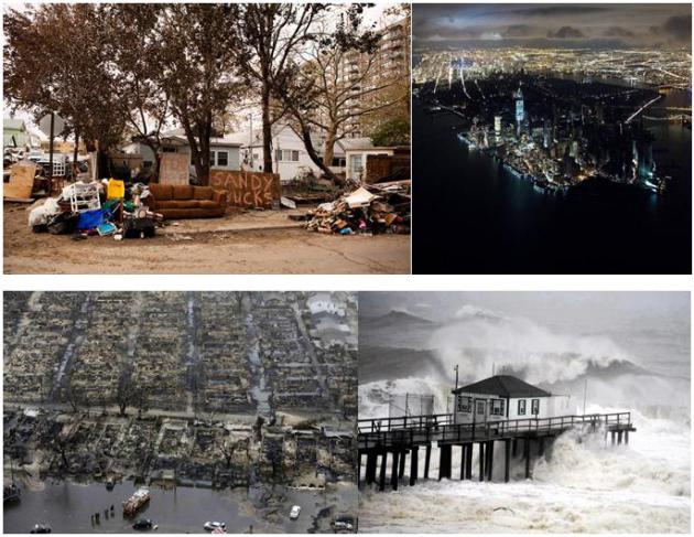
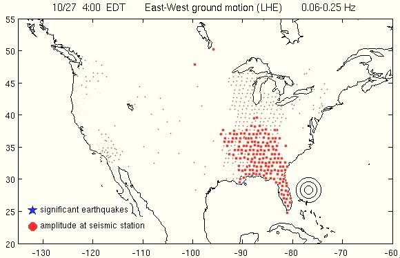
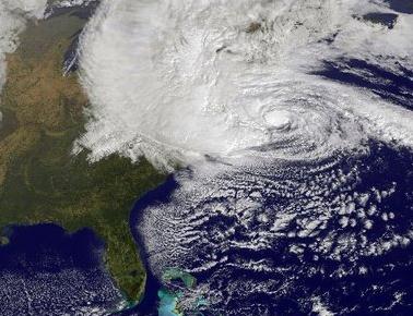
Sandy Shook U.S. Like An Earthquake. How severe was
Sandy? Powerful enough to physically shake the ground many hundreds of
miles away. Here's an excerpt of an amazing article and animation at
Our Amazing Planet: "
Hurricane
Sandy pummeled the United States from Florida to Wisconsin, and its
fierce winds caused a vast swath of ground to shake, a new
earthquake-monitoring animation shows. The visualization shows seismic
stations lit up as the storm approached Florida on Oct. 26. The
earthquake monitors detected rolling seismic waves
caused by Sandy's fierce winds out at sea. The earthquake-monitoring
network always "hears" a continuous hum of background noise generated
in the ocean, called microseism, said Alex Hutko, a seismologist at the
Incorporated Research Institutions for Seismology (IRIS) in Seattle,
and creator of the Hurricane Sandy animation..."
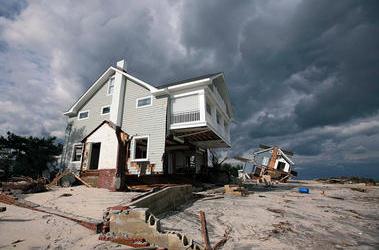
Surging Storms: Can The US Adapt In Time To Avert Coastal Damage.
I would hazard a guess that the short answer is an emphatic no. We're
allowing people to build homes in high-risk coastal areas, and rebuild
after major storms like Sandy on a consistent basis. Insanity is defined
as doing the same thing over and over, expecting different results.
Mandatory federal insurance is required for people living close to sea
level, and taxpayers indirectly contribute to this ongoing treadmill of
rebuilding. It's the third rail of politics - nobody wants to say it out
loud, but too many people are building in areas prone to repeated storm
surges from hurricanes and Nor'easters. Private insurance companies
won't touch these policies - and for good reason. Here's an excerpt of
an article at
The Christian Science Monitor: "...
Indeed,
damage from tropical systems such as Sandy are projected to multiply
by the end of the century as the population grows and people put more
assets in harm's way. That's true whether or not global warming, which
many researchers say is feeding extreme-weather events, is factored in.
Tropical-cyclone damage now runs about $26 billion a year globally,
according to a study published in January in the journal Nature
Climate Change. By 2100, increases in population and wealth as
economies grow could push that number to $56 billion a year, assuming
little or no effort to adapt to the hazard..."
Photo credit above: "
Houses in Bayhead, N.J., showed
effects of Sandy Nov. 2. Rising populations and seas, and more severe
weather, may mean $100 billion a year in global damage by 2100." Tim Larsen/New Jersey Governor’s Office/Reuters.
We Survived Hurricane Sandy. Now What? Here's a clip from a first-person account of Sandy at
Huffington Post: "
I
live on the Texas Gulf Coast. I have lived through a lot of
hurricanes and tropical storms. Yet last month, I flew into New York
City for a hurricane. Why? Following my recent book launch, I had a lot
of important media events, including a potentially game-changing TEDx
talk, scheduled starting on October 30. This SQ work is my passion and
mission. I didn't want to miss these events because of cancelled
flights. So I left on the second-to-last flight out of Houston to
Newark, and arrived at my hotel hoping that Sandy would be more hype
than horror. As a storm veteran, I brought a flashlight, extra
batteries, boxes of granola bars, and other food with me. I verified
that the hotel had a backup generator just in case. I confirmed we were
not in the Zone A evacuation area. I stocked up on some bottled
water, filled the tub, and hunkered down. Over the next few days, the
local news crew became my primary companions..."
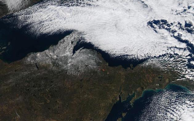
Lake Effect Snow From Space. The high-resolution ("MODIS") satellite from NASA boasts resolutions as good as 250 meters. Here's an excerpt from a recent
NOAA post describing favorable conditions for lake effect snow bands: "
Snowfall
reports from Cooperative Observers, Spotters, and Social Media
indicated anywhere from 2-6 inches of snow fell over Northwest Upper
Michigan as of the morning of 11/13. In addition, locations east of
Munising near Lake Superior received up to 3 inches of snow (seen
through the clouds from Pictured Rocks National Lakeshore to Newberry).
The widespread area of Lake Effect Snow highlights the areas that are
favored by West to Northwest winds, as the snow quickly diminished
after passing over the Huron Mountains (produced just a light dusting in
Marquette). This was due to the combination of downslope wind off the
higher terrain and the snow showers being removed from the influence of
Lake Superior. This lack of snow continued to the east of Marquette
until the Pictured Rocks National Lakeshore, where the West-Northwest
winds allowed a long enough residence time over Lake Superior to produce
lake effect snow. To see a listing of snowfall reports from this lake
effect snow, click here."
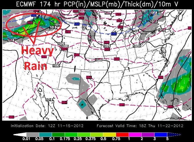
Thanksgiving Preview. ECMWF model data (courtesy of
WSI) shows unusually mild, dry weather across most of the USA next
Thursday; slightly cooler air dribbling southward from Fargo to the Twin
Cities. The only rain in the extended outlook: Pacific Northwest, from
Seattle to Portland. Old Man Winter will continue to pull his punch over
the Lower 48 States thru the last weekend of November.
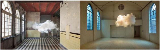
"Indoor Clouds". Here's an excerpt of a fascinating post (and experiment) at
mashable.com: "
Dutch artist Berndnaut Smilde
has developed a way to create clouds indoors by carefully regulating
the space’s humidity, temperature and light. This intersection of
science and art was recently named one of TIME magazine’s “Best Inventions of the Year 2012.”
The fluffy white clouds are summoned up temporarily using a fog
machine, creating a surreal experience in the middle of a room. Smilde
has created his clouds inside different types of locations, ranging from
corridors and hallways, to bedrooms and common spaces..."
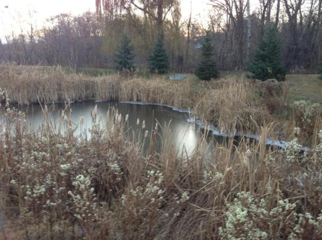
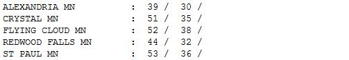 A Break From Winter
.
If it could only stay like this for the next 4 months...? No, snow
lovers would not be happy, but I suspect a significant percentage of
Minnesotans would be just fine with this state of affairs. Snap out of
your daydream - this too shall pass, but not for the better part of 10
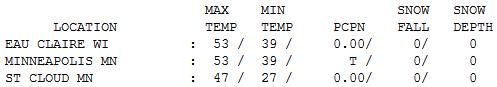
days, based on latest guidance. Thursday highs ranged from 39 at
Alexandria to 47 St. Cloud, and 53 in the Twin Cities and Eau Claire.
"
Set impossible challenges. Then catch up with them" - Sir Richard Branson
Paul's Conservation Minnesota Outlook for the Twin Cities and all of Minnesota:
TOAY: Sunny and cooler. Winds: SE 7-12. High: 43
FRIDAY NIGHT: Clear to partly cloudy. Low: 31
SATURDAY: Partly sunny and breezy. S 10-20. High: 51
SUNDAY: Mix of clouds and sun, a dry sky. Low: 36. High: 56
MONDAY: Patchy clouds, passing sprinkle? Low: 38. High: 55
TUESDAY: Plenty of sun, very nice. Low: 39. High: 57
WEDNESDAY: Indian Summer rerun. Wow. Low: 43. High: 61
THANKSGIVING DAY: Cooler front. Lukewarm turkey with patchy clouds. Risk of gravy. Low: 35. High: near 50
Climate Stories....
Has Obama Turned A Corner On Climate Change? The story from
The Christian Science Monitor; here's an excerpt: "...
If
the message is somehow we’re going to ignore jobs and growth simply to
address climate change, I don’t think anybody’s going to go for that,"
Obama said. "I won’t go for that." Obama dismissed the inverse
relationship some ascribe to environmentalism and job growth. The
president instead endorsed an agenda that both advances economic growth
while making "a serious dent in climate change." In what is likely an
allusion to hurricane Sandy,
Obama emphasized the importance of long-term, proactive investments in
infrastructure as a means of reducing the reconstruction costs
incurred by extreme weather events..."
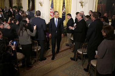
Photo credit: "
President Obama leaves the East Room of
the White House in Washington, Wednesday, following his first news
conference after his reelection. Mr. Obama addressed the subject of
climate change at some length in response to a reporter's question." Jacquelyn Martin/AP
Be Persuasive. Be Brave. Be Arrested (if necessary).
Think climate change can't effect your investment portfolio? Think
again. Here's a clip of a thought-provoking paper and warning at
nature.com: "
I
have yet to meet a climate scientist who does not believe that global
warming is a worse problem than they thought a few years ago. The
seriousness of this change is not appreciated by politicians and the
public. The scientific world carefully measures the speed with which we
approach the cliff and will, no doubt, carefully measure our rate of
fall. But it is not doing enough to stop it. I am a specialist in
investment bubbles, not climate science. But the effects of climate
change can only exacerbate the ecological trouble I see reflected in the
financial markets — soaring commodity prices and impending shortages..."
 America's Carbon Compromise
. Here's an excerpt of a new paper at
Nature: "
This
week, a reinvigorated Barack Obama returned to the White House knowing
that he was poised on the edge of a fiscal cliff. Rather than
relishing his victory last week, Obama must immediately set about
crafting a compromise on deficit reduction with congressional leaders.
The stakes could hardly be higher — for science, for US citizens and,
indeed, for the world. In the event of failure, a budgetary time-bomb of
tax increases and sweeping budget cuts will detonate on 2 January. As
well as resulting in indiscriminate cuts to funds for scientific
research and many other areas, it could knock the United States back
into recession and deliver yet another blow to an already fragile global
economy..." Image: Clean Technica.
Obama Says He Will Elevate National Climate Change "Conversation". Here's an excerpt from a story at
Climate Science Watch: "
A
New York Times reporter asked President Obama at his White House news
conference today: "What specifically do you plan to do in a second term
to tackle the issue of climate change?" The President's reply included
this: "What I'm going to be doing over the next several weeks, next
several months, is having a conversation, a wide-ranging conversation
with scientists, engineers, and elected officials to find out what can
-- what more can we do to make a short-term progress in reducing
carbons, and then working through an education process that I think is
necessary -- a discussion, a conversation across the country about what
realistically can we do long term to make sure that this is not
something we're passing on to future generations that's going to be very
expensive and very painful to deal with."
"Time To Do Something About The Weather". Here's an excerpt of a timely Op-Ed at Milwaukee's
Journal Sentinel: "
There
was precious little discussion of climate change during the
presidential campaign and most other political races this year. That may
strike some as a little surprising, given the weather that's been
plaguing much of the nation over the past couple of years, which has
cost billions of dollars of damage and taken hundreds of lives. Maybe
politicians think that climate change has become the new third rail of
politics (it used to be Social Security, but these days everyone's
talking about Social Security), but on this issue they're way behind
everyone else. They need to catch up and start making some real
proposals on how to mitigate both the trend and the effects - and they
need to start doing so as soon as new members are seated in Congress and
President Barack Obama renews his oath in January. The people are
paying attention. According to a national survey released Tuesday, a
large majority of Americans (77%) say global warming should be a "very
high," "high" or "medium" priority for the president and Congress..."


No comments:
Post a Comment