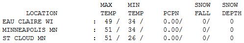
51 F. high in the Twin Cities Wednesday.
42 F. average high for November 14.
52 F. high on November 14, 2011.
2.19" rain since September 1; 4.16" less than normal for that period.
Dry weather expected Thanksgiving Day, highs near 50 as clouds increase.
30s next Friday ("Black Friday"). You'll need a heavy jacket for power-shopping after Turkey Day.
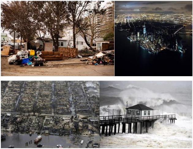
Misplaced Priorities. Maybe it's just me, but the
media's sudden obsession with "the Petreus affair" seems way off-base,
considering the carnage, heartache and loss on the east coast in the
wake of Sandy.
This web site
sums up the hypocrisy of leading with lurid tales of sex at high
levels, when hundreds of thousands of Americans are trying to put their
lives back together again. It's worth a look.
Lowered Expectations
"Hey Paul, will we see any more 70s anytime
soon?" Yes. Late March. Lower your expectations and you won't be
disappointed. For now be joyously content with 50s.
Maybe I'm turning into a hopeless curmudgeon,
but the national media's strange obsession with "The Petreus Affair", at
a time when hundreds of thousands of east coast residents are still
trying to pick up the pieces of their lives, in the wake of Sandy, seems
like a profound case of misplaced priorities. OK. I'm not shocked.
What is surprising is the lack of "big weather"
between now and Thanksgiving. After cooling off Friday the mercury tops
50 Saturday into Thanksgiving Day; the usually reliable ECMWF (European)
model is hinting at 60 F. next Wednesday.
Cue the chorus of angels.
It's a welcome break from the wicked winds of winter, a far cry from Monday's ice and wind chill.
But stating the obvious: our drought continues
to worsen. NOAA is predicting some long term improvement for central
Minnesota, but conditions may worsen over far southern counties.
Weather patterns will probably favor the biggest, wettest storms detouring south and east of Minnesota into December.
One silver lining: next week's Nor'easter will stay out to sea, a badly needed break.
A Quiet Week. ECMWF model data shows dry weather
lingering thru the end of next week. The only chance of a (rain) shower?
Monday. Highs nudge 50 over the weekend and Monday, again next
Wednesday and even Thanksgiving Day, followed by a significant cool-down
on "Black" Friday of next week. You may need a heavy jacket for power
shopping with highs in the 30s.
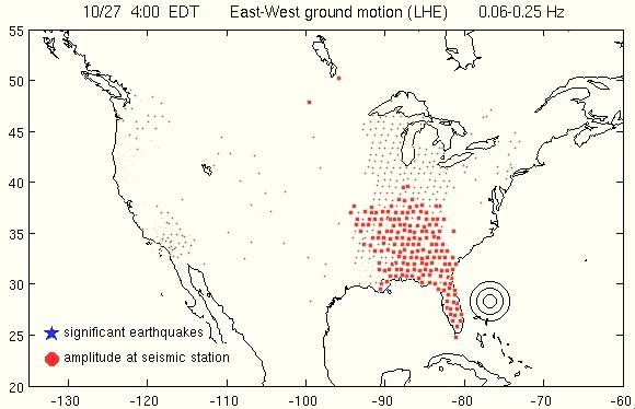
Sandy Shook U.S. Like An Earthquake. How severe was
Sandy? Powerful enough to physically shake the ground many hundreds of
miles away. Here's an excerpt of an amazing article and animation at
Our Amazing Planet: "
Hurricane
Sandy pummeled the United States from Florida to Wisconsin, and its
fierce winds caused a vast swath of ground to shake, a new
earthquake-monitoring animation shows. The visualization shows seismic
stations lit up as the storm approached Florida on Oct. 26. The
earthquake monitors detected rolling seismic waves
caused by Sandy's fierce winds out at sea. The earthquake-monitoring
network always "hears" a continuous hum of background noise generated
in the ocean, called microseism, said Alex Hutko, a seismologist at the
Incorporated Research Institutions for Seismology (IRIS) in Seattle,
and creator of the Hurricane Sandy animation..."
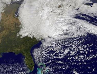
Surging Storms: Can The US Adapt In Time To Avert Coastal Damage.
I would hazard a guess that the short answer is an emphatic no. We're
allowing people to build homes in high-risk coastal areas, and rebuild
after major storms like Sandy on a consistent basis. Insanity is defined
as doing the same thing over and over, expecting different results.
Mandatory federal insurance is required for people living close to sea
level, and taxpayers indirectly contribute to this ongoing treadmill of
rebuilding. It's the third rail of politics - nobody wants to say it out
loud, but too many people are building in areas prone to repeated storm
surges from hurricanes and Nor'easters. Private insurance companies
won't touch these policies - and for good reason. Here's an excerpt of
an article at
The Christian Science Monitor: "...
Indeed,
damage from tropical systems such as Sandy are projected to multiply
by the end of the century as the population grows and people put more
assets in harm's way. That's true whether or not global warming, which
many researchers say is feeding extreme-weather events, is factored in.
Tropical-cyclone damage now runs about $26 billion a year globally,
according to a study published in January in the journal Nature
Climate Change. By 2100, increases in population and wealth as
economies grow could push that number to $56 billion a year, assuming
little or no effort to adapt to the hazard..."
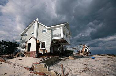
Photo credit above: "
Houses in Bayhead, N.J., showed
effects of Sandy Nov. 2. Rising populations and seas, and more severe
weather, may mean $100 billion a year in global damage by 2100." Tim Larsen/New Jersey Governor’s Office/Reuters.
We Survived Hurricane Sandy. Now What? Here's a clip from a first-person account of Sandy at
Huffington Post: "
I
live on the Texas Gulf Coast. I have lived through a lot of
hurricanes and tropical storms. Yet last month, I flew into New York
City for a hurricane. Why? Following my recent book launch, I had a lot
of important media events, including a potentially game-changing TEDx
talk, scheduled starting on October 30. This SQ work is my passion and
mission. I didn't want to miss these events because of cancelled
flights. So I left on the second-to-last flight out of Houston to
Newark, and arrived at my hotel hoping that Sandy would be more hype
than horror. As a storm veteran, I brought a flashlight, extra
batteries, boxes of granola bars, and other food with me. I verified
that the hotel had a backup generator just in case. I confirmed we were
not in the Zone A evacuation area. I stocked up on some bottled
water, filled the tub, and hunkered down. Over the next few days, the
local news crew became my primary companions..."
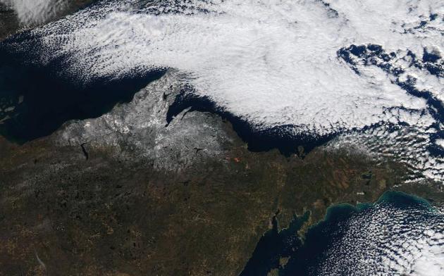
Lake Effect Snow From Space. The high-resolution ("MODIS") satellite from NASA boasts resolutions as good as 250 meters. Here's an excerpt from a recent
NOAA post describing favorable conditions for lake effect snow bands: "
Snowfall
reports from Cooperative Observers, Spotters, and Social Media
indicated anywhere from 2-6 inches of snow fell over Northwest Upper
Michigan as of the morning of 11/13. In addition, locations east of
Munising near Lake Superior received up to 3 inches of snow (seen
through the clouds from Pictured Rocks National Lakeshore to Newberry).
The widespread area of Lake Effect Snow highlights the areas that are
favored by West to Northwest winds, as the snow quickly diminished
after passing over the Huron Mountains (produced just a light dusting in
Marquette). This was due to the combination of downslope wind off the
higher terrain and the snow showers being removed from the influence of
Lake Superior. This lack of snow continued to the east of Marquette
until the Pictured Rocks National Lakeshore, where the West-Northwest
winds allowed a long enough residence time over Lake Superior to produce
lake effect snow. To see a listing of snowfall reports from this lake
effect snow, click here."
Thanksgiving Preview. ECMWF model data (courtesy of
WSI) shows unusually mild, dry weather across most of the USA next
Thursday. The only rain in the extended outlook: Pacific Northwest,
around Seattle and Tacoma. A colder front plows southward across the
Dakotas into Minnesota late Thursday, resulting in a more wintry sting
by Friday of next week.
Thanksgiving Preview. Our friends at
Planalytics
have put together a good graphic, showing how weather next Thursday
compares with a year ago: cooler over the eastern half of the USA,
considerably wetter over the west coast.
Mellow November. Were we really slipping and sliding
Monday morning, after a whopping 2/10ths of an inch of snow? Yesterday
was easy on the soul, under a mostly-blue sky highs ranged from 46 at
Alexandria to 51 St. Cloud and the Twin Cities to 54 at Redwood Falls.
Paul's Conservation Minnesota Outlook for the Twin Cities and all of Minnesota:
TODAY: Partly sunny, pleasant. Winds: NW 10. High: near 50
THURSDAY NIGHT: Mostly clear and chilly. Low: 25
FRIDAY: Bright sun, cooler. High: 44
SATURDAY: Periods of sun, milder again. Low: 31. High: 53
SUNDAY: Mix of clouds and sun, still quiet. Low: 33. High: 52
MONDAY: More clouds, passing shower or sprinkle? Low: 36. High: 51
TUESDAY: Sun returns, October-like. Low: 34. High: 54
WEDNESDAY: Hints of Indian Summer. Very nice! Low: 39. High: near 60
THANKSGIVING DAY: Clouds increase, still milder than average - probably dry. High: 51
"BLACK FRIDAY": Bright sun, a cold wind - feels like November again. High: 35
Climate Stories....
Obama Says He Will Elevate National Climate Change "Conversation". Here's an excerpt from a story at
Climate Science Watch: "
A
New York Times reporter asked President Obama at his White House news
conference today: "What specifically do you plan to do in a second term
to tackle the issue of climate change?" The President's reply included
this: "What I'm going to be doing over the next several weeks, next
several months, is having a conversation, a wide-ranging conversation
with scientists, engineers, and elected officials to find out what can
-- what more can we do to make a short-term progress in reducing
carbons, and then working through an education process that I think is
necessary -- a discussion, a conversation across the country about what
realistically can we do long term to make sure that this is not
something we're passing on to future generations that's going to be very
expensive and very painful to deal with."
"Time To Do Something About The Weather". Here's an excerpt of a timely Op-Ed at Milwaukee's
Journal Sentinel: "
There
was precious little discussion of climate change during the
presidential campaign and most other political races this year. That may
strike some as a little surprising, given the weather that's been
plaguing much of the nation over the past couple of years, which has
cost billions of dollars of damage and taken hundreds of lives. Maybe
politicians think that climate change has become the new third rail of
politics (it used to be Social Security, but these days everyone's
talking about Social Security), but on this issue they're way behind
everyone else. They need to catch up and start making some real
proposals on how to mitigate both the trend and the effects - and they
need to start doing so as soon as new members are seated in Congress and
President Barack Obama renews his oath in January. The people are
paying attention. According to a national survey released Tuesday, a
large majority of Americans (77%) say global warming should be a "very
high," "high" or "medium" priority for the president and Congress..."


No comments:
Post a Comment