45 F. high in the Twin Cities Tuesday.
31 F. average high for December 4.
29 F. high on December 4, 2011.
.8" snow has fallen so far this winter season in the metro area.
11.5" should have fallen at KMSP since September 1.
7.8" snow had fallen last winter, as of December 4.
Minnesota Snow Lotto
A few hardy snowbirds are extending their stay
in Minnesota, while my e-mails from snow lovers become increasingly
indignant. "I demand some snow. I want it now!" I hear you.
Sadly, Mother Nature doesn't care.
According to NOAA 7 percent of the lower 48
states have snow on the ground. Last year at this time: 29 percent was
snow covered. No, this doesn't mean another wimpy winter is imminent,
but I suspect another compressed, abbreviated winter for the USA.
Canadian air laps southward in waves, each push
of chilled air spinning up a scrawny clipper. Enough cold air may be in
place for a slushy accumulation Sunday - too early to speculate about
amounts, but I doubt this will be "The Big One".
Ignore the calendar: "Meteorological Winter",
marking the start of the coldest 90 days of the year, kicked off last
Saturday, December 1.
Expect 40s again by Thursday, a weekend near freezing,
then 20s early next week. Seasonably cold, but nothing that will make
you put your travel agent on speed dial.
According to State Climatologist Greg Spoden
Monday's 55 degree high was rare for December at MSP. Weather records
kept since 1872 show a total of 20 December days with highs above 55 F.
Where's The Snow? According to
NOAA
a little over 7% of the Lower 48 have snow on the ground. You have to
drive up into far northern Minnesota to see a covering of white, which
is a bit off for early December, a little more than 2 weeks from the
Winter Solstice. Last year at this time snow was reported over 29% of
the USA (exclusing Alaska and Hawaii).
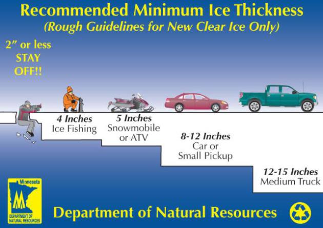
Stay Off The Ice. As we stumble into another
potentially anemic winter, with sub-freezing temperatures alternating
with thaws, the quality and quantity of ice will be problematic, at
least until we get a few (sustained) weeks below freezing. Remind your
kids (and spouses) that the ice is far from safe. More details from the
Minnesota DNR.
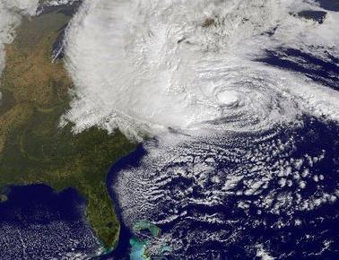
Another Close Call. We just can't buy a storm this
winter season - as expected most storms are detouring south/east of
Minnesota, symptoms of a mild El Nino pattern, which tends to favor big
storms for the west coast, and the southern and eastern USA. The drought
signal continues to be powerful over the northern Plains. The predicted
map for midday Sunday shows a little wet snow over southern Minnesota,
the best chance of a light, slushy accumulation from Rochester into
central Wisconsin. Right now I can't get too excited about amounts here
in the Twin Cities. ECMWF map above: WSI.
A Little Weekend Slush? No, I doubt it'll be enough
to ski on, or fire up the snowmobile, but a "nuisance" slush event is
possible Saturday and Sunday, the most significant surge of moisture
sailing just south and east of MSP. ECMWF guidance above for the Twin
Cities (temperatures in Celsius). Don't panic.
Warm Bias To Continue. The map above shows an
experimental (NAEFS) temperature outlook for December 12 - 18,
indicating a milder than normal bias for much of the USA and eastern
Canada into mid December. A couple of clippers will pull cold air into
the northern tier states, but no (savage) cold is in sight - yet. Image:
NOAA.
Tracking Powerful "Atmospheric River" Winter Storms.
Water vapor has increased by 4-5%, especially over the tropics,
providing more fuel for storms. When weather patterns become locked or
"blocked" these streams of concentrated water vapor, dubbed "atmospheric
rivers" can focus a fire-hose of moisture on the west coast, as
described in this story from
NOAA:
"...“With satellites, we can see the tell-tale water vapor signature
of an incoming atmospheric river over the ocean. However, NOAA’s
offshore observing systems do not measure another key factor — strong
low-altitude winds,” said Martin Ralph, Ph.D., a research
meteorologist and branch chief in NOAA’s Earth System Research
Laboratory in Boulder, Colo. “With our new sensors, we’ll be able to
measure those winds and more, to understand just how much moisture is
moving in, which largely controls how extreme the precipitation inland
will become. This information will ensure that meteorologists and
emergency managers have additional information to keep the public
informed about these potentially destructive storms.” (Image: KQED).
The four coastal observatories will include:
- A Doppler wind profiling radar, which reveals the speed and direction of winds at several altitudes aloft;
- A technique for extracting critical information from wind
profiler data — the level in the atmosphere where falling snow turns to
rain;
- Global positioning system (GPS) water vapor instruments, which measure the total amount of water vapor above the site; and
- Standard meteorological instruments (relative humidity, temperature, pressure, rain gauge)."
Physicist Happens Upon Rain Data Breakthrough.
I love these stories of accidental discoveries and serendipity, but this
is how the (sometimes awkward) arc of science works. Here's a snippet
from
Science Daily: "..."
It's
not often that you're studying lunar dust and it ends up producing
benefits in weather forecasting," said Phil Metzger, a physicist who
leads the Granular Mechanics and Regolith Operations Lab, part of the
Surface Systems Office at Kennedy. Lane said the additional piece of
information would be useful in filling out the complex computer
calculations used to determine the current conditions and forecast the
weather. "We may be able to refine (computer weather) models to make
them more accurate," Lane said. "Weather radar data analysis makes
assumptions about raindrop size, so I think this could improve the
overall drop size distribution estimates." (Photo courtesy of Mike Hall).
UI Researcher Predicts More Intense North Atlantic Tropical Storms.
Even if I had the money, I wouldn't dream of buying a beach house on
the ocean. No, Minnesota's lakes are looking like a safer bet, long
term. Here's an excerpt of an article from
The University of Iowa: "
Tropical
storms that make their way into the North Atlantic, and possibly
strike the East Coast of the United States, likely will become more
intense during the rest of this century. That’s the prediction of one
University of Iowa researcher and his colleague as published in an
early online release in the prestigious Journal of Climate, the
official publication of the American Meteorological Society. The study
is a compilation of results from some of the best available computer
models of climate, according to lead author Gabriele Villarini,
assistant professor of civil and environmental engineering and
assistant research engineer at IIHR-Hydroscience & Engineering, and
his colleague Gabriel Vecchi of the National Oceanic and Atmospheric
Administration, Princeton, N.J...."
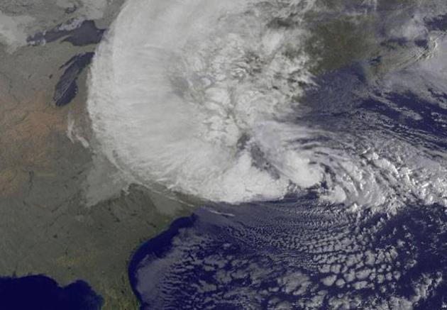
Image credit above: "NOAA's
GOES-13 satellite captured this visible image of Hurricane Sandy
battering the U.S. East coast on Monday, Oct. 29 at 9:10 a.m. EDT.
Sandy's center was about 310 miles south-southeast of New York City.
Tropical Storm force winds are about 1,000 miles in diameter. Image
courtesy of NASA GOES Project."
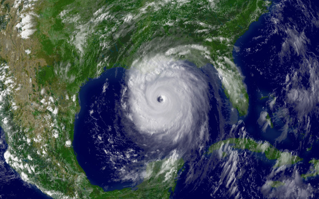
NASA Study Could Improve Hurricane Strength Forecasts. Phys.org has the story
here. Katrina image courtesy of NOAA.
Global Water Crisis: Too Little, Too Much, Or Lack Of A Plan? Here's a clip from an illuminating story at
Yahoo News: "...
But superstorm Sandy's deluge and flooding, says Geoff Dabelko, an environmental expert at Ohio University in Athens,
is an example of how the term "global water crisis" can be misleading.
It tends to imply that there's just one kind of crisis – a water
shortage. "The kind of dead-cow-carcass-in-the-desert image that global 'water crisis'
evokes is very real for some people," Professor Dabelko says. "But
there are so many dimensions." Too much water – whether from flooding,
sea level rise, or more extreme storms – can be just as deadly as too
little. While the balance between water supplies and the demands of a
burgeoning population are further complicated by the effect of climate change
on delicate hydrological margins, there are those who say there is
enough water, if nations learn to plan for a different future – one in
which past abundance is no guide..."
Top 5 Weather And Climate Challenges Facing White House. Meteorologist Andrew Freedman has the story from
Climate Central; here's an excerpt:
1) Building a More Weather and Climate Resilient Society
Hurricane Sandy, which killed 85 people in the U.S. and caused at least $72 billion in damage in New York and New Jersey alone,
highlighted the need to bolster the resilience of coastal cities so
that they can withstand the increasing threat posed by the 1-2 punch of
global warming-related sea level rise and major storms. Steps that may
need to be taken include installing sea walls or storm surge barriers
to better protect populated areas, as well as potentially retreating
from some vulnerable locations that are almost certain to flood again,
given current sea level rise projections. It could also involve
reforming the federal flood insurance program, which currently provides
incentives to rebuild in vulnerable areas..."
Satellite image credit: NASA.
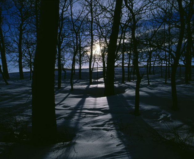
Not Bad For Early December. We continue to limp into
winter; highs reached the 40s across much of central and southern
Minnesota yesterday. Maximum temperatures ranged from 21 at
International Falls (no snow on the ground, which is remarkable for
December 4) to 41 St. Cloud and 46 in the Twin Cities.
Minnesota Weather History on December 4. Information courtesy of the
Twin Cities NWS:
2001: Warm December day with a
high of 63 degrees at the Twin Cities. Summer-like thunderstorms
developed and dropped quarter-sized hail at the Eyota Post Office in
Olmsted County.
1979: December warmth: 52 at St. Cloud, 54 at Browns Valley.
1928: Canby received three inches of snow or greater for the third consecutive day.
Paul's Conservation Minnesota Outlook for the Twin Cities and all of Minnesota:
TODAY: Sunny start, clouds increase. Winds: SE 10-20. High: 38
WEDNESDAY NIGHT: Mostly cloudy, sprinkle or light shower possible. Low: 35
THURSDAY: Clouds, passing shower or two. High: 43
FRIDAY: Mostly cloudy and colder, few flurries. Low: 28. High: 35
SATURDAY: Seasonably cold. Cloudy with a chance of flurries or very light snow. Low: 26. High: 33
SUNDAY: A little wet snow. Slushy roads south and east of MSP? Low: 28. High: 31
MONDAY: Sun returns, better travel weather, but colder. Low: 17. High: 27
TUESDAY: Potential for a Chicago snowstorm? Gray, dry here. Low: 18. High: 28
Climate Stories...
Treat Climate Change As A "Waste Management Problem". Spoken
like a true engineer, and absolutely true. But we've never had a waste
management problem of this scale and severity. Everything we do,
everywhere we go, all things manufactured and consumed hinges on carbon,
the extraction and burning of fossil fuels. But maybe this guy is onto
something. Here's an excerpt from
Consumer Energy Report: "...
The
debate for me is over because I believe we have the technology
available to us today to develop hydrocarbons and to use those
hydrocarbons in ways in which we can use them fully and clean up after
ourselves; with respect to physical waste, liquid waste, and gaseous
waste. So if we approach the issue of global warming/climate change as
an issue of waste management – which I would prefer to do – rather than
some kind of global crisis which remains undefined and unresolved.
Let’s deal with what we know how to deal with. We know how to deal with
waste..."
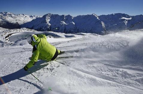
How Has Climate Change Affected Your Winter Sports?
What winter sports? Oh yeah - it's meteorological winter out there, at
least on paper. Lately it seems like Minnesotans experience all or
nothing winters. Either we get buried under 70" or more of snow (once
every 4 or 5 winters, on average) or we see dribs and drabs of snow
(last winter comes to mind). Here's a clip from
The PBS NewsHour: "
The
winter of 2011 was so unusually warm and dry, it left some ski resorts
struggling to create enough powder to sustain their season. Winter
sports enthusiasts are now facing the possibility of another warm, dry
winter, which means more snow machines and fewer skiers, snowboarders
and outdoor skaters. We want to hear from you -- how have the changing
seasons affected your favorite winter pastimes? Are you a skier,
snowboarder or ice-skater who has had to travel farther to find snow
and ice? Have fewer snow days meant less time sledding? Have winter
tournaments or outdoor games been cancelled or rescheduled due to
unseasonably warm weather?"
Photo credit above: "
A skier glides down a slope in
Austria. Climate change threatens to alter winter weather patterns,
which would affect beloved outdoor pastimes." Photo by Dominic Ebenbichler/Reuters.
U.S. Price Tag For Allergies Will Rise Because Of Climate Change.
Scientific American has the story; here's an excerpt: "
Researchers are probing the health and economic fallout from this year's record allergy season to understand how warming weather
and shifting rainfall may lead to more widespread and costlier allergy
problems in the future. Already, doctors are seeing climate change alter
how allergens disperse. "It played out in the form of the duration of
the pollen season," said Leonard Bielory, an attending physician and
allergist at the Robert Wood Johnson University Hospital and a
professor at Rutgers University's Center for Environmental Prediction..." (Photo: Tricia Frostad).
Why Seeing Is Believing - Usually - When It Comes To Climate Change.
Wait. Climate change requires connecting the dots and a concept known
as "thinking"? Uh oh. We're in trouble. Here's an excerpt from an
interesting article at
Time Magazine:
"One possible explanation for these low levels of belief
certainty and perceptions of the threat as distantis that climate change
is difficult to perceive directly; `climate’ itself is a statistical
abstraction, even though its impacts can be quite tangible. Current
theories of cognitive science suggest that learning about abstractions
requires analytical information processing, which involves cognitive
efforta scarce commodity, which people expend sparingly. Both
low motivation to think about climate change and low ability
to comprehend scientific information can impede people’s processing of
the charts, graphs and models in the climate scientist’s toolkit.
In other words, climate change is hard to really see in one’s
daily life, and understanding it requires “analytic information
processing”—otherwise known as thinking. That’s not something people
have a lot of time, inclination (and perhaps ability) to do..."


Different machinery are introducing for measuring climatic conditions, similarly Temperature Recorders measures heat in temperature.
ReplyDelete