36 F. high in the Twin Cities Wednesday.
30 F. average high for December 5.
22 F. high temperature on December 5, 2011.
3" snow on the ground in the Twin Cities on December 5, 2011.
6" snow on the ground in the Twin Cities on December 5, 2010.
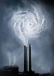
Snow Drought
"Paul, why can I still see my puke-colored lawn
on December 6?" Proving cause and effect with something as complicated
as the atmosphere is always problematic, but my gut? Drought. With a
dash of climate change thrown in for good measure.
Some numbers: we should have seen 11.5 inches of
snow by now. Last year 7.8 inches of fluff had already fallen. So far
in 2012? A whopping 8 tenths of an inch of snow.
Heating degree data from the National Weather
Service shows a warm bias since July; we've saved about 11 percent on
heating bills during that period. It feels like December in Tulsa.
Again.
Snowy rumors are filling the airwaves for this weekend. My advice?
Keep your expectations low. Saturday still appears to be the better
travel day; a streak of wet snow may drop an inch or two of slushy snow
Sunday; heavier snow north of the metro area. Plowable up north?
Perhaps. Here at MSP? Enough slush to stare out the window and pretend
it's winter.
Significantly colder air arrives by mid-December; highs in the 20s.
Another storm late next week may drop a light accumulation; once again
the best chance north of the cities.
At this rate Santa may have to ditch the sleigh for a big, red SUV. But don't give up on a white Christmas just yet...
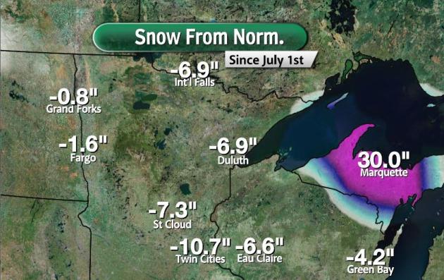
Snowfall Departure From Normal. The MSP metro area
is running a 10.7" snowfall deficit, to date. Even Duluth and
International Falls are seeing a snowfall slump; the only (reliable)
snow coming from lake effect downwind of Lake Superior.
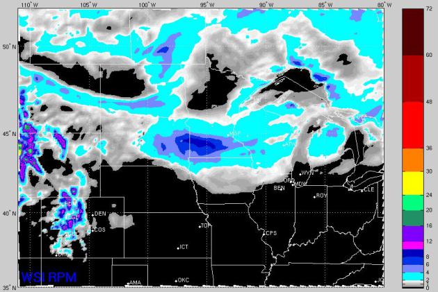
72 Hour Snowfall Prediction. WSI's high-res "RPM"
model is printing out some 2"+ amounts over central and southern
Minnesota by Saturday night, maybe as much as 3-5" south and west of the
Twin Cities. Not buying it just yet, but there's certainly a chance of
accumulating snow this weekend.
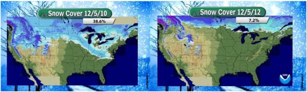
USA Snowcover Comparison. The (NOAA) map in the
upper left is from December 5, 2010, snow on the ground as far south as
the Carolinas, significant snowcover over Minnesota and Wisconsin. 38%
of the USA had snow on the ground 2 years ago. The map in the upper
right shows a thin gruel of snowcover from Montana and North Dakota into
Minnesota's BWCA and the U.P. of Michigan, resembling something out of
early October, rather than early December, with snow reported over just
7% of the Lower 48.
Where's The Snow? According to
NOAA
a little over 7% of the Lower 48 have snow on the ground. You have to
drive up into far northern Minnesota to see a covering of white, which
is a bit off for early December, a little more than 2 weeks from the
Winter Solstice. Last year at this time snow was reported over 29% of
the USA (exclusing Alaska and Hawaii).
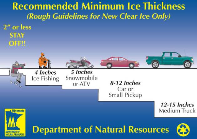
Stay Off The Ice. As we stumble into another
potentially anemic winter, with sub-freezing temperatures alternating
with thaws, the quality and quantity of ice will be problematic, at
least until we get a few (sustained) weeks below freezing. Remind your
kids (and spouses) that the ice is far from safe. More details from the
Minnesota DNR.
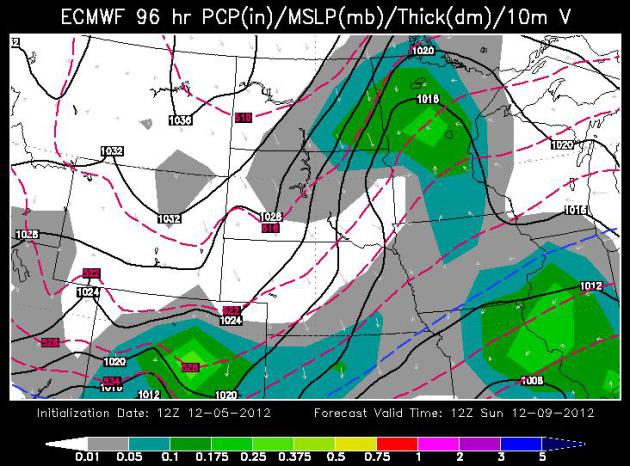
Sunday Slush? The ECMWF forecast for 12z Sunday
(courtesy of WSI) shows the best chance of a fast-moving burst of snow
over central and northern Minnesota; a potentially
"plowable" accumulation up north. It's still too early to go into
specifics, but if you're traveling this weekend you'll want to stay up
on the latest forecast.
Accurate Flood Forecasting Gets Closer. Flash
flooding and river flooding is a short-fuse meteorological challenge.
Predicting flooding severity is literally a science within a science.
Phys.org has an interesting story on new technology that may help to pinpoint extreme rainfall amounts and subsequent flooding.
Tracking Powerful "Atmospheric River" Winter Storms.
Water vapor has increased by 4-5%, especially over the tropics,
providing more fuel for storms. When weather patterns become locked or
"blocked" these streams of concentrated water vapor, dubbed "atmospheric
rivers" can focus a fire-hose of moisture on the west coast, as
described in this story from
NOAA:
"...“With satellites, we can see the tell-tale water vapor signature
of an incoming atmospheric river over the ocean. However, NOAA’s
offshore observing systems do not measure another key factor — strong
low-altitude winds,” said Martin Ralph, Ph.D., a research
meteorologist and branch chief in NOAA’s Earth System Research
Laboratory in Boulder, Colo. “With our new sensors, we’ll be able to
measure those winds and more, to understand just how much moisture is
moving in, which largely controls how extreme the precipitation inland
will become. This information will ensure that meteorologists and
emergency managers have additional information to keep the public
informed about these potentially destructive storms.” (Image: KQED).
The four coastal observatories will include:
- A Doppler wind profiling radar, which reveals the speed and direction of winds at several altitudes aloft;
- A technique for extracting critical information from wind
profiler data — the level in the atmosphere where falling snow turns to
rain;
- Global positioning system (GPS) water vapor instruments, which measure the total amount of water vapor above the site; and
- Standard meteorological instruments (relative humidity, temperature, pressure, rain gauge)."
Physicist Happens Upon Rain Data Breakthrough.
I love these stories of accidental discoveries and serendipity, but this
is how the (sometimes awkward) arc of science works. Here's a snippet
from
Science Daily: "..."
It's
not often that you're studying lunar dust and it ends up producing
benefits in weather forecasting," said Phil Metzger, a physicist who
leads the Granular Mechanics and Regolith Operations Lab, part of the
Surface Systems Office at Kennedy. Lane said the additional piece of
information would be useful in filling out the complex computer
calculations used to determine the current conditions and forecast the
weather. "We may be able to refine (computer weather) models to make
them more accurate," Lane said. "Weather radar data analysis makes
assumptions about raindrop size, so I think this could improve the
overall drop size distribution estimates." (Photo courtesy of Mike Hall).
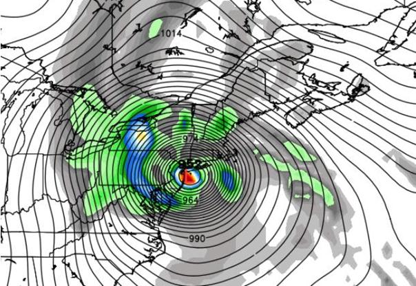
Hurricane Warning Definition Modified By NHC In The Wake Of Sandy.
NOAA received a fair amount of criticism for dropping hurricane
warnings as Sandy's warm core center became absorbed into a massive
extra-tropical storm, a classic Nor'easter, but one on a gargantuan
scale. Here's an excerpt from Accuweather and
Huffington Post: "
Following
the criticism of the National Hurricane Center's handling of Hurricane
Sandy and the non-issuance of hurricane warnings north of North
Carolina, it has been decided that the NHC will now have more
flexibility in their policy regarding the issuance of advisories.
Beginning in 2013, the NHC will have the flexibility to issue multiple
advisories on post-tropical cyclones for landfalling systems or close
bypassers. According to the NHC, this required a revision of the
Hurricane Warning definition, which will now be as follows:
An announcement that sustained winds of 74 mph or higher
are expected somewhere within the specified area in association with a
tropical, sub-tropical, or post-tropical cyclone. Because hurricane
preparedness activities become difficult once winds reach tropical storm
force, the warning is issued 36 hours in advance of the anticipated
onset of tropical-storm-force winds. The warning can remain in effect
when dangerously high water or a combination of dangerously high water
and waves continue, even though winds may be less than hurricane force."
UI Researcher Predicts More Intense North Atlantic Tropical Storms.
Even if I had the money, I wouldn't dream of buying a beach house on
the ocean. No, Minnesota's lakes are looking like a safer bet, long
term. Here's an excerpt of an article from
The University of Iowa: "
Tropical
storms that make their way into the North Atlantic, and possibly
strike the East Coast of the United States, likely will become more
intense during the rest of this century. That’s the prediction of one
University of Iowa researcher and his colleague as published in an
early online release in the prestigious Journal of Climate, the
official publication of the American Meteorological Society. The study
is a compilation of results from some of the best available computer
models of climate, according to lead author Gabriele Villarini,
assistant professor of civil and environmental engineering and
assistant research engineer at IIHR-Hydroscience & Engineering, and
his colleague Gabriel Vecchi of the National Oceanic and Atmospheric
Administration, Princeton, N.J...."
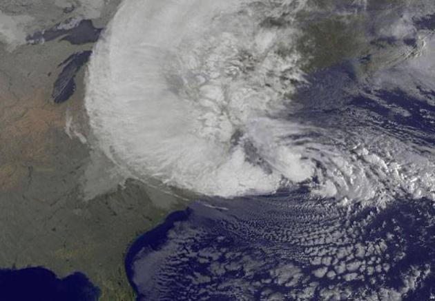
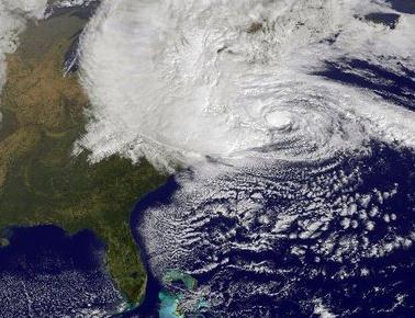
Image credit above: "NOAA's
GOES-13 satellite captured this visible image of Hurricane Sandy
battering the U.S. East coast on Monday, Oct. 29 at 9:10 a.m. EDT.
Sandy's center was about 310 miles south-southeast of New York City.
Tropical Storm force winds are about 1,000 miles in diameter. Image
courtesy of NASA GOES Project."
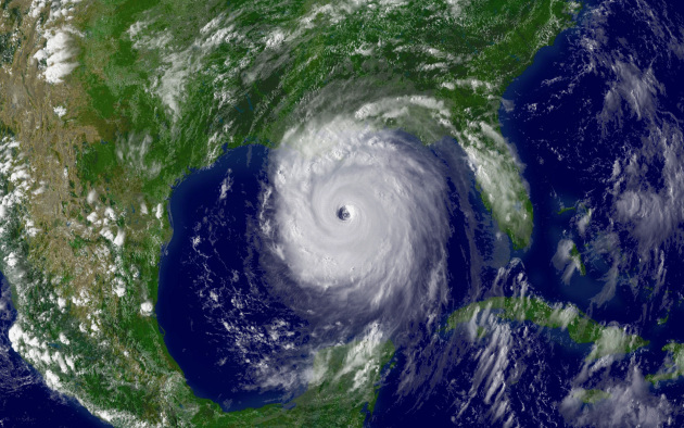
NASA Study Could Improve Hurricane Strength Forecasts. Phys.org has the story
here. Katrina image courtesy of NOAA.
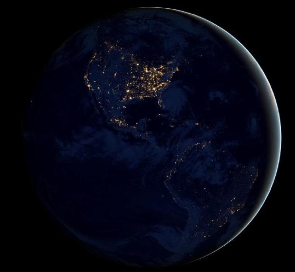
Earth At Night. Here's a look at how these new nighttime images were created, courtesy of
NASA: "
This
new global view of Earth's city lights is a composite assembled from
data acquired by the Suomi National Polar-orbiting Partnership (NPP)
satellite. The data was acquired over nine days in April 2012 and 13
days in October 2012. It took 312 orbits to get a clear shot of every
parcel of Earth's land surface and islands. This new data was then
mapped over existing Blue Marble imagery of Earth to provide a realistic
view of the planet. The image was made possible by the satellite's
"day-night band" of the Visible Infrared Imaging Radiometer Suite,
which detects light in a range of wavelengths from green to
near-infrared and uses filtering techniques to observe dim signals such
as city lights, gas flares, auroras, wildfires and reflected moonlight..."
Global Water Crisis: Too Little, Too Much, Or Lack Of A Plan? Here's a clip from an illuminating story at
Yahoo News: "...
But superstorm Sandy's deluge and flooding, says Geoff Dabelko, an environmental expert at Ohio University in Athens,
is an example of how the term "global water crisis" can be misleading.
It tends to imply that there's just one kind of crisis – a water
shortage. "The kind of dead-cow-carcass-in-the-desert image that global 'water crisis'
evokes is very real for some people," Professor Dabelko says. "But
there are so many dimensions." Too much water – whether from flooding,
sea level rise, or more extreme storms – can be just as deadly as too
little. While the balance between water supplies and the demands of a
burgeoning population are further complicated by the effect of climate change
on delicate hydrological margins, there are those who say there is
enough water, if nations learn to plan for a different future – one in
which past abundance is no guide..."
Top 5 Weather And Climate Challenges Facing White House. Meteorologist Andrew Freedman has the story from
Climate Central; here's an excerpt:
1) Building a More Weather and Climate Resilient Society
Hurricane Sandy, which killed 85 people in the U.S. and caused at least $72 billion in damage in New York and New Jersey alone,
highlighted the need to bolster the resilience of coastal cities so
that they can withstand the increasing threat posed by the 1-2 punch of
global warming-related sea level rise and major storms. Steps that may
need to be taken include installing sea walls or storm surge barriers
to better protect populated areas, as well as potentially retreating
from some vulnerable locations that are almost certain to flood again,
given current sea level rise projections. It could also involve
reforming the federal flood insurance program, which currently provides
incentives to rebuild in vulnerable areas..."
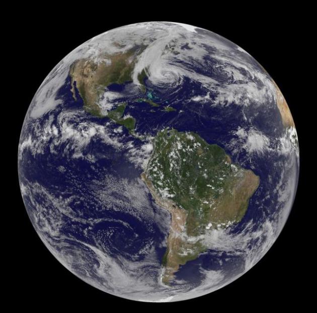
Satellite image credit: NASA.
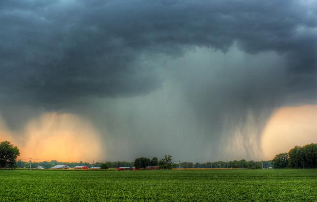
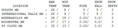
 Closer To Average
.
After 55 Monday and mid-40s Tuesday, Wednesday saw a return of
seasonable chill, daytime highs ranging from 27 at Hibbing to 35 St.
Cloud, 36 in the Twin Cities, and 42 at Redwood Falls.
Minnesota Weather History on December 5. Information courtesy of the
Twin Cities NWS:
1950: A snowstorm hits Duluth with 23.2 inches of snow in 24 hours, and a storm total of 35.2 inches.
1939: December heat wave. High temperature hits 62 at New London.
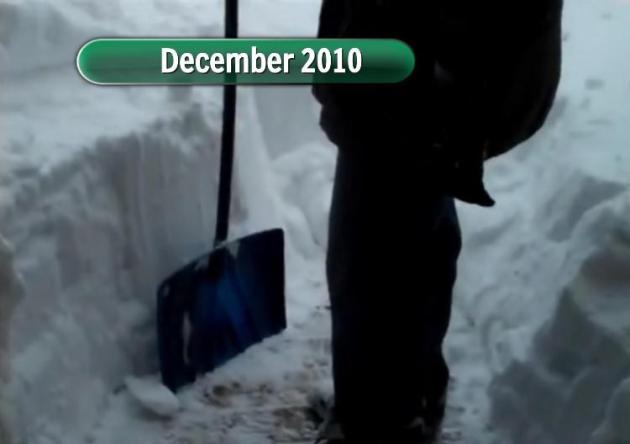
* photo above courtesy of WeatherNation TV meteorologist Todd Nelson,
who was the one doing the heavy-duty shoveling 2 years ago. It's
amazing (at least to me) how Decembers can vary so much from year to
year.
Paul's Conservation Minnesota Outlook for the Twin Cities and all of Minnesota:
TODAY: Morning shower or sprinkle possible. Mild start, then turning cooler. Winds: NW 10-15. High: 44
THURSDAY NIGHT: Partly cloudy and chilly again. Low: 24
FRIDAY: Mostly cloudy, a coating of wet snow possible late. High: 33
SATURDAY: Gray, but dry much of the day. Low: 21. High: 35
SATURDAY NIGHT: A mix of rain and snow, an inch or two of slush possible. Some icy roads. Low: 29
SUNDAY: Snow tapers to flurries in the metro - a few inches possible up north. Some roads may be slick. High: 33
MONDAY: Gradual clearing, drying out. Cold wind. Low: 17. High: 26
TUESDAY: Clouds increase, still chilly. Low: 16. High: 28
WEDNESDAY: Some sun, breezy. Thawing out late. Low: 19. High: 33
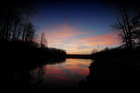
* photo above taken near Westerville, Ohio, courtesy of Brian Gustafson.
Climate Stories...
Forecasting Denial: Why Are TV Weathercasters Ignorning Climate Change? Here's an excerpt of a
Rolling Stone
story, focused on denial within the TV meteorology community. Why are
some TV forecasters still leaning on ideology vs. acknowledging
legitimate scientific trends? Here is what I told R.S. environmental
writer Jeff Goodell: "...
It's not always a matter of ideology,
though. Many broadcasters are simply afraid that any talk of global
warming will dampen ratings and scare off advertisers. "Talking about
climate change is kryptonite for TV meteorologists," says Paul Douglas, a veteran TV weathercaster and reformed climate skeptic who is now the chief meteorologist at Alerts Broadcaster,
which specializes in severe weather alerting services. "They tend to
abhor anything that might turn viewers off and make it harder for them
to renegotiate a big, fat, six-figure salary. By even bringing up the
topic, you know you're going to alienate the percentage of the audience
who still link global warming with Al Gore and conspiracy theories. Why
run into the buzz saw of denial? It's easier to stick to safe topics,
like dew point and hot weather survival tips...."
Climate Out Of Control. Why are so many TV
meteorologists reluctant to talk about climate change during their
weather reports? There's a long list of reasons, some legitimate. I was
recently interviewed by Jim Poyser (along with TV meteorologists in
Orlando) for an article that appeared in
Orlando Weekly. Here's an excerpt:
"JP: When did you begin to actually talk about climate change as part of your job as a broadcast meteorologist?
PD: In the late '90s I began including it in my weather statements.
JP: Was anybody else doing it at that time?
PD: No, no. The pervasive feeling at the time was that … if you
even mention the term global warming or climate change you will
instantly alienate 30 percent of your audience and they will tune out.
So, you know, it's kryptonite.
Every day I would get scores of emails like, "Flaming liberal.
You crazy crackpot. Why are you buying into this Al Gore conspiracy?
You're going to cripple our economy." It is the equivalent of sticking
your finger in the electrical socket. Most of us are conditioned to
avoid pain, to avoid controversy. Everybody on television wants to be
loved and your contract – whether you're renewed – really depends on
your ability to attract an audience. Just by reporting on this you know
that you're alienating people with a certain ideology...."
* Hurricane Sandy satellite image above courtesy of NASA.
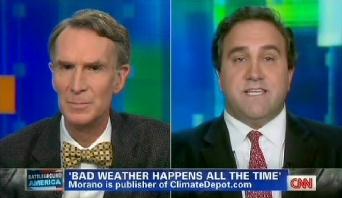
CNN Gives Climate Change Denial A Platform. I
watched this spectacle Tuesday evening. Bill Nye (the science guy) did
an admirable job, but why they didn't have a climate scientist to talk
about the trends is baffling. The media wants "balance"? Then CNN should
have had a panel of 98 peer-reviewed scientists debating 2 fossil-fuel
industry shills. That would have been journalistically balanced. But a
TV food-fight makes for better ratings, right?
Media Matters has the story; here's an excerpt: "...
If
the role of the media is to inform its audience, anchors must
recognize how people are informed and misinformed. When people are
repeatedly exposed to a myth, it becomes more familiar
and they are more likely to believe it. By giving Morano a platform to
claim that average temperatures have not warmed in nearly 20 years,
Morgan enabled him to familiarize CNN's audience with climate myths.
It's not surprising that Morano seized the opportunity to spread
confusion about climate change. His website is sponsored
by the Committee for a Constructive Tomorrow, an organization that has
received funding from oil companies. As New York Times reporter Andrew
Revkin explained,
"industry-funded groups have used the media's tradition of quoting
people with competing views to convey a state of confusion even as
consensus on warming has built." Morano has promoted extreme attacks on
climate scientists and those that accept global warming. His website
often publishes
the email addresses of scientists, leading to a barrage of hate mail,
and he defended a billboard campaign comparing those who accept climate
science to the Unabomber, saying it was "edgy."
Bill Kurtis On Global Warming. One of the (few) good
things to come out of my brief stint in Chicago was working with Bill
Kurtis, a legendary anchor, reporter and award-winning journalist. And a
decent human being, the kind of guy you'd want to have a beer with.
Here is his take on climate change, an excerpt of a recent Op-Ed at
The Chicago Sun Times: "...
A
small number of skeptics have managed to take the adrenaline out of
the global warming movement; and by creating the impression that there
are actually two sides to the issue, they have stalled efforts to do
something about it. I’ve been producing documentaries on global warming
for 20 years and have seen the early warnings of extreme weather
events come true. Predictions of stronger hurricanes now have names
—
Katrina and Sandy. Greater forest fires recall the Colorado Springs fire
last June. More droughts — this year’s drought in the Midwest is the
worst in more than 50 years. The prediction that glaciers will be gone
from Glacier National Park has been moved up by 10 years to 2020, the
same year it’s predicted the Arctic Sea will be ice-free in the summer..."
Treat Climate Change As A "Waste Management Problem". Spoken
like a true engineer, and absolutely true. But we've never had a waste
management problem of this scale and severity. Everything we do,
everywhere we go, all things manufactured and consumed hinges on carbon,
the extraction and burning of fossil fuels. But maybe this guy is onto
something. Here's an excerpt from
Consumer Energy Report: "...
The
debate for me is over because I believe we have the technology
available to us today to develop hydrocarbons and to use those
hydrocarbons in ways in which we can use them fully and clean up after
ourselves; with respect to physical waste, liquid waste, and gaseous
waste. So if we approach the issue of global warming/climate change as
an issue of waste management – which I would prefer to do – rather than
some kind of global crisis which remains undefined and unresolved.
Let’s deal with what we know how to deal with. We know how to deal with
waste..."
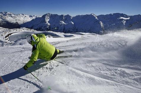
How Has Climate Change Affected Your Winter Sports?
What winter sports? Oh yeah - it's meteorological winter out there, at
least on paper. Lately it seems like Minnesotans experience all or
nothing winters. Either we get buried under 70" or more of snow (once
every 4 or 5 winters, on average) or we see dribs and drabs of snow
(last winter comes to mind). Here's a clip from
The PBS NewsHour: "
The
winter of 2011 was so unusually warm and dry, it left some ski resorts
struggling to create enough powder to sustain their season. Winter
sports enthusiasts are now facing the possibility of another warm, dry
winter, which means more snow machines and fewer skiers, snowboarders
and outdoor skaters. We want to hear from you -- how have the changing
seasons affected your favorite winter pastimes? Are you a skier,
snowboarder or ice-skater who has had to travel farther to find snow
and ice? Have fewer snow days meant less time sledding? Have winter
tournaments or outdoor games been cancelled or rescheduled due to
unseasonably warm weather?"
Photo credit above: "
A skier glides down a slope in
Austria. Climate change threatens to alter winter weather patterns,
which would affect beloved outdoor pastimes." Photo by Dominic Ebenbichler/Reuters.
U.S. Price Tag For Allergies Will Rise Because Of Climate Change.
Scientific American has the story; here's an excerpt: "
Researchers are probing the health and economic fallout from this year's record allergy season to understand how warming weather
and shifting rainfall may lead to more widespread and costlier allergy
problems in the future. Already, doctors are seeing climate change alter
how allergens disperse. "It played out in the form of the duration of
the pollen season," said Leonard Bielory, an attending physician and
allergist at the Robert Wood Johnson University Hospital and a
professor at Rutgers University's Center for Environmental Prediction..." (Photo: Tricia Frostad).
Why Seeing Is Believing - Usually - When It Comes To Climate Change.
Wait. Climate change requires connecting the dots and a concept known
as "thinking"? Uh oh. We're in trouble. Here's an excerpt from an
interesting article at
Time Magazine:
"One possible explanation for these low levels of belief
certainty and perceptions of the threat as distant as that of climate
change is difficult to perceive directly; `climate’ itself is
a statistical abstraction, even though its impacts can be
quite tangible. Current theories of cognitive science suggest
that learning about abstractions requires analytical
information processing, which involves cognitive effort...a
scarce commodity, which people expend sparingly. Both low motivation to
think about climate change and low ability to comprehend scientific
information can impede people’s processing of the charts, graphs and
models in the climate scientist’s toolkit.
In other words, climate change is hard to really see in one’s
daily life, and understanding it requires “analytic information
processing”—otherwise known as thinking. That’s not something people
have a lot of time, inclination (and perhaps ability) to do..."


No comments:
Post a Comment