By Paul Douglas
"May you live in interesting times." No kidding. Top national weather story of 2012? Sandy. Or was it the warmest year ever observed for the USA? 4 times more record highs than record lows? Maybe the record derecho that swept from Indiana to D.C. Record Arctic ice loss? That may have been a factor in America's weather getting stuck, with blast-furnace heat much of the summer. We went from record floods in 2011 to record drought in 2012, the worst, nationwide, since 1956. So no, I'm not really sure what the top story of 2012 was. Take your pick.
El Nino may be nudging the storm track south of Minnesota; New York City cleaning up from heavy rain & more coastal flooding, with blizzard conditions from Indianapolis to Cleveland and Syracuse. While we sit up here on the cold, crusty tundra, watching cobwebs form on the Doppler.
A cosmetic snowfall is possible from tonight into Friday, an inch or two not out of the question. Just enough to cover up the gently used snow-stubble in your yard. 20 F will feel good today. A family of clippers keep us chilly into New Year's Eve, but milder days are ahead. I see a January Thaw in just over a week.
Yes, we're getting off easy.
____________________________________________________________________________________
Todd's Conservation MN Outlook for the Twin Cities and all of Minnesota:
THURSDAY: Clouds increase, late flurries. High: 21 Winds: E 5-10mph
THURSDAY NIGHT: Snow develops, light dusting by morning. Low: 16
FRIDAY: Light snow continues. Light shoveling duties by the evening. High: 24
SATURDAY: Mostly cloudy, good travel weather. Low: 12. High: 20
SUNDAY: More sun, chilling breeze. Low: 7. High: 19.
NEW YEAR'S EVE: Intervals of sun. So long 2012. Low: 4. High: 20
NEW YEAR'S EVE NIGHT: Mostly Cloudy during the countdown. Low: 12
NEW YEAR'S DAY: More sun. Welcome 2013! High: 18
WEDNESDAY: Moslty sunny. Still cool. Low: 10. High: 18.
____________________________________________________________________________
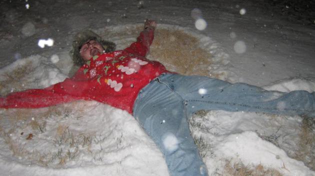
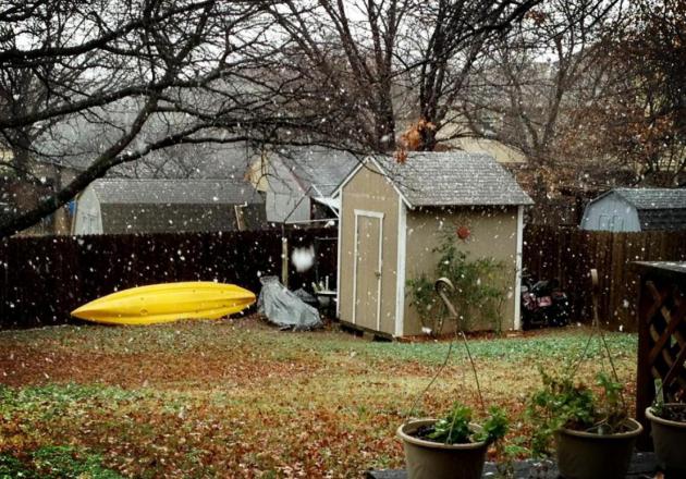
Texas Snow Angels
I've heard of the
Los Angeles Angels, but never Texas snow angels... Thanks to the
National Weather Service out of Amarillo, TX for the picture below. One
of their employees had a little fun on Christmas morning.
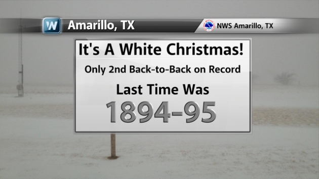
Amarillo, TX White Christmas
By the way, last
year was a "White Christmas" in Amarillo and it was again this year
making it only the 2nd back-to-back white Christmas in recorded
history. The last time it happened was in 1894-95!
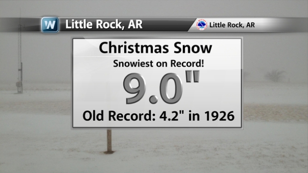
Little Rock Snow
Heavy snow blanketed parts of Arkansas on
Christmas and Little Rock ended up with their snowiest Christmas ever
in recorded history! (Image below courtesy NWS Little Rock, AR)
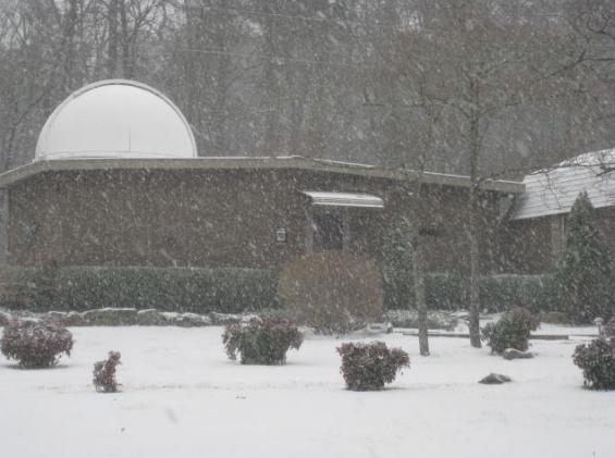
Record Snow in Little Rock on Christmas Day!
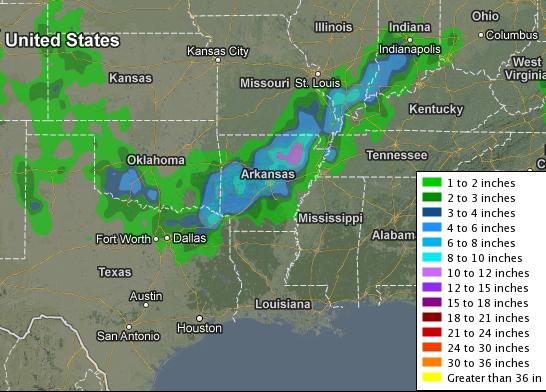
Deep South Snow
Take a look at the snowfall analysis from
earlier this week. Note how far south the snow is! Dallas/Ft. Worth,
TX even had snow on Christmas Day!
Texas Snow
Thanks to @TripleG25 for the picture below... Snow in Arlington, TX
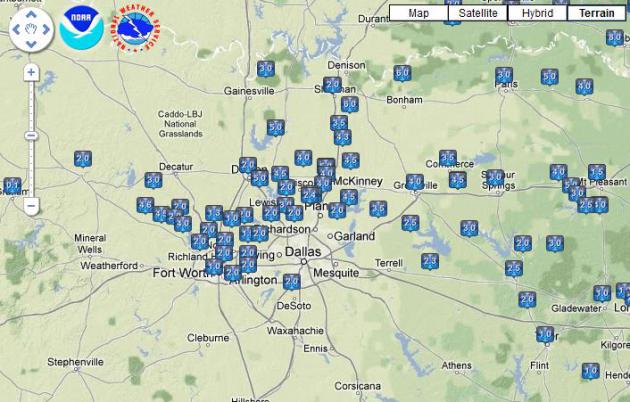
Dallas/Ft. Worth TX Snow Reports
Here are some of the snow reports from the Dallas/Ft. Worth, TX area from Christmas Day.
Heaviest Snow Tallies (Central U.S.)
Here are some of the snow tallies, there were several reports of over 12" with more to come in the Northeast through Thursday!

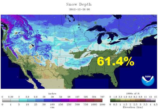
Massive U.S. Snow Cover
Take a look at the U.S. snow cover from early Wednesday. According to NOAA, 61.4% of the nation was covered in snow!
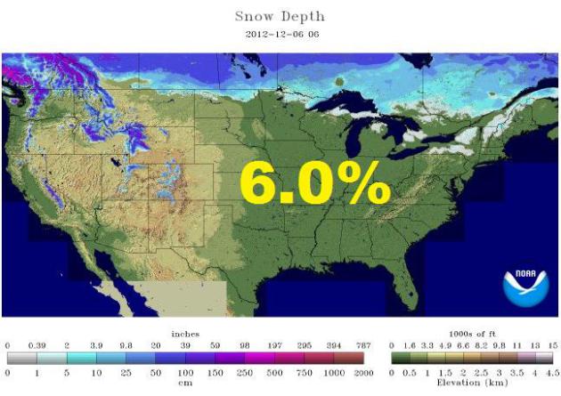
Early December 2012 Snow Pack
According
to NOAA, on December 6th only 6.0% of the nation was covered in snow!
That's a HUGE difference in just a matter of weeks!
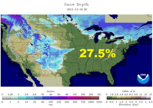
2011 U.S. Snow Cover
Last year at this time, only 27.5% of the nation was covered in snow...
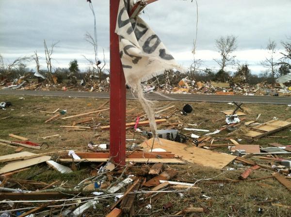
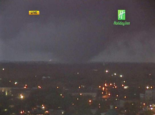
December Twisters
Crazy day
in the weather department on Christmas Day. Not only were we tracking
heavy snow/blizzard-like condtions, but we were also tracking severe
weather and tornadoes! Take a look at this picture out of TX.
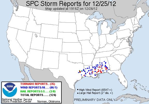
Christmas Day Storm Reports
Take a look
at the storm report map from Christmas Day. As of midday Wednesday,
there were 35 preliminary tornado reports with several injuries from
Texas to Alabama.
"Worst Christmas Tornado Outbreak Ever? Storms Slam The U.S. During 2012 Holiday Season"
"A
far-reaching storm system tore across the South on Tuesday, causing what
is likely to go into the record books as the worst Christmas Day
tornado outbreak on record. The storm responsible for the severe weather
also spread a swath of snow and ice from Texas to Indiana, and the
whole mess of extreme weather slid east on Wednesday, with a string of
blizzard warnings that stretched at least 700 miles across seven states
as of midday Wednesday."
"In this
image from video provided by WALA-TV in Mobile, Ala. a tornado touches
down in Mobile on Tuesday, Dec. 25, 2012. The tornado hit some areas of
downtown Mobile Tuesday, causing severe damage in the area before moving
north, officials said. (AP Photo/WALA-TV) MANDATORY CREDIT: WALA-TV"
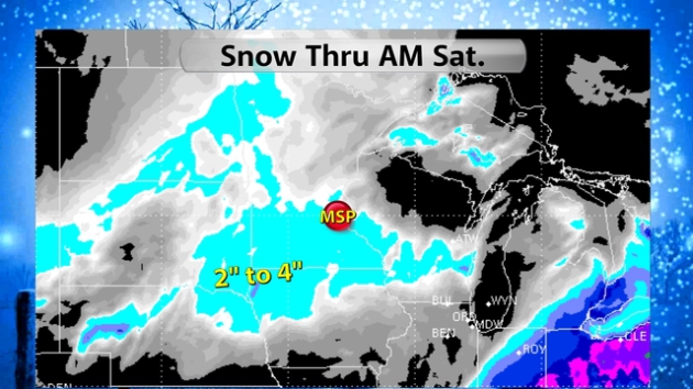
More Snow on the Way...
A fairly
week wave will move through the High Plains and Upper Mississippi Valley
by the end of the week with light accumulation potential. I could see
some light shoveling duties by PM Friday.
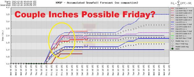
Minneapolis MN Meteogram
Here's a
meteogram from Minneapolis, MN for the upcoming wintry event. Several
models suggest at least a couple of inches through PM Friday.
Thanks for checking in and have a great rest of your week!
Don't forget to follow me on Twitter @TNelsonWNTV

No comments:
Post a Comment