0 F. low temperature in the metro area Christmas morning.
13 F. high in the Twin Cities Christmas Day.
25 F. average high on December 25.
42 F. high temperature on December 25, 2011.
No significant storms brewing thru the first week of January.
The Great Escape
I once mocked snowbirds. No more. The secret to
surviving a Minnesota winter intact? Good shoes, a warm coat, and a few
trips to thaw out your soul.
My dear wife of 28 years and I have a December
tradition: every year we pick a destination we haven't been to,
preferably far away (to rack up Delta MQM Skymiles). This year:
Istanbul. With any luck we won't show up on CNN.
At least the weather is quiet; a little too
quiet, as storms slam into the west, then parade across the southern and
eastern USA.
"Too cold to snow?" There's some truth to this
old adage. When temperatures are in single digits or teens the main
storm track is usually too far south for heavy accumulations. Christmas
Day was as cold as it's going to get, in fact I'm tracking a thaw by the
second week of January. Spring is NOT right around the corner, but I
see no evidence of bitter air invading the Gopher State anytime soon.
A coating of flakes may grease up a few roads Friday. That's about as exciting as it gets into early 2013.
While we enjoy chilly & boring Europe is
seeing jaw-dropping extremes: record cold in Russia & severe floods
in the U.K. My relatives in Germany reported 72 F. in Munich on Sunday!
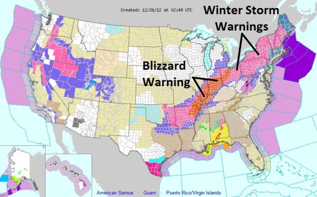
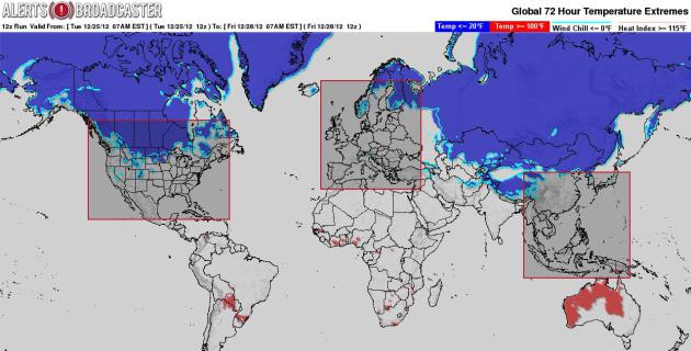
Another Day in Paradise: Blizzard, With A Risk of Tornadoes.
Post-Christmas travelers heading south or east of Minnesota will be
tormented by foul weather today, a stripe of heavy snow from Texas to
New England; blizzard conditions from Arkansas to Indianapolis to
Toledo. A few isolated tornadoes are possible across the Carolinas. NOAA
has the latest watches and warnings
here.
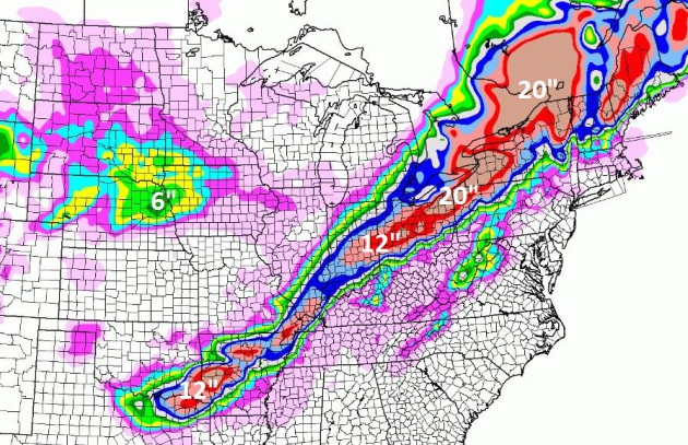
84 Hour Snowfall Potential.
Here is the NAM model solution for snowfall amounts into early Saturday.
A foot of snow for northeastern Texas? Travel-crushing snows are
possible from Indianapolis to Toledo, Columbus and Cleveland, Buffalo,
Syracuse and Rochester, New York.
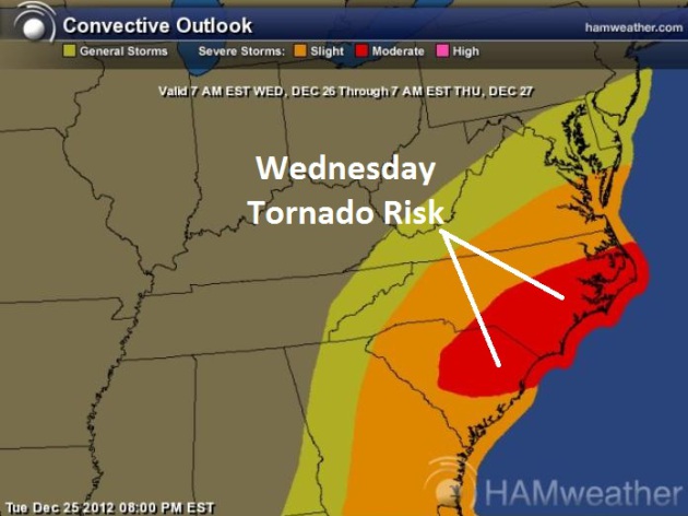
Tornado Potential. As of 9 pm
yesterday 17 confirmed tornadoes from SPC. An intense storm may spawn
more supercell thunderstorms later today, a few more large, violent,
long-lasting tornadoes possible from Columbia, South Carolina to
Charlotte, Raleigh and the Outer Banks of North Carolina.
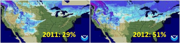
2012: A Whiter Christmas Nationwide.
NOAA
data shows 51% of the lower 48 states had snow on the ground yesterday,
compared with only 29% of the USA a year ago. Does that mean a tougher,
rest-of-the-winter? It remains to be seen.
2012 MSP Review, Month by Month. Yes, it was a warm
year - possibly the warmest ever recorded across most of Minnesota.
After a wet spring precipitation fell off a moisture cliff by late
summer. Here is a summary of temperatures and precipitation departures
(above or below normal) from the
Minnesota Climatology Working Group:
January + 7.7 F (.54" drier)
February: +6.9 F (.94" wetter)
March: +15.5 F (.49" drier)
April: + 2.5 F (.38" wetter)
May: + 4.6 F (5.98" wetter)
June: +3.5 F. (.66" drier)
July: + 6.4 F (.86" wetter) * second hottest month on record for KMSP.
August: + .8 F (2.92" drier)
September: + 1.9 F (2.78" drier)
October: -1.4 F. (1.13 drier)
November: +3.4 F. (1.14" drier)
December: + 5.9 F (.57 wetter) * first 24 days of this month.
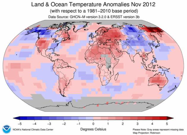
November 2012: The Warming Trend Continues. Here's an excerpt from
NOAA NCDC: "
The
globally-averaged temperature for November 2012 marked the fifth
warmest November since record keeping began in 1880. November 2012 also
marks the 36th consecutive November and 333rd consecutive month with a global temperature above the 20th century average..."
More Than 4 Times More Record Highs Than Record Lows In 2012. The chart above shows
NOAA NCDC
records as of yesterday: 66,094 record highs (daytime highs and record
warm nighttime lows) vs. 15,264 record lows for 2012, to date.
2012: Second Costliest Year For Weather Disasters On Record? According to
NOAA NCDC it
now looks like Sandy, the growing drought, record June derecho and
other factors will probably make 2012 even costlier than 2011, when 14
separate billion dollar weather disasters were observed; second only to
2005, when 4 hurricanes (including Katrina) hit the USA. Details: "
NOAA
is announcing preliminary information that the U.S. experienced 11
disasters each costing over a billion dollars in losses in 2012. Of
these 11 events, seven were severe weather or tornado events, and two
were related to hurricanes/post tropical cyclones. The remaining two
were the year-long drought and associated wildfires....Economic losses
for two events, Sandy and the year-long Drought, are the big drivers
this year in terms of costs and are still being calculated. It will
take months to develop a final reliable estimate for each. Given how
big these events are likely to be, NCDC estimates that 2012 will surpass 2011
($60.6 billion, CPI-adjusted to 2012 dollars) in terms of aggregate
costs for annual billion-dollar disasters, even with less number of
disasters. The greatest annual loss was 2005 ($187.2 billion,
CPI-adjusted to 2012 dollars)...."
Photo credit: Glenn Stubbe, Star Tribune.
Insert Yawn Here. On some level I'm happy for the
quiet weather. Great news for holiday travelers, and seniors (myself
included) who don't have to worry quite as much about traffic messes and
slipping on ice. The ECMWF guidance (above) shows a coating of flurries
Friday - otherwise dry weather into next week. No weather drama for New
Year's festivities this year, with temperatures within a few degrees of
average.
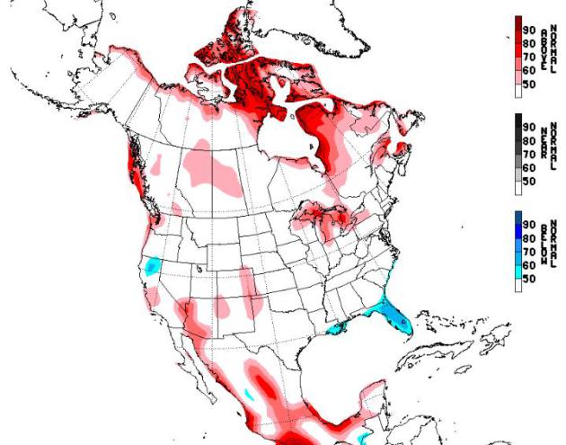
Where's The (Really) Cold Air? Yes, most Minnesotans
would grudgingly admit that it's "cold enough" out there - but I'm
wondering where the (typical) January subzero blast is? NAEFS long-range
guidance from NOAA CPC shows much of North America trending warmer than
average from January 2-8, 2013. Still can't get used to seeing 2013 in
print. Where's my 'dang flying car and robotic butler?
Extreme Weather In Europe Stuns Scientists - "Unusual Configuration Of The Jet Stream". Here's an excerpt from an article at
beforeitsnews.com: "...
The
cold has claimed 90 lives in Russia since mid-December and 83 in
Ukraine, with eastern Eurasia in the grips of an unusually icy month
that has seen temperatures drop to as low as minus 50 degrees C in
eastern Siberia. Another 57 people have died from the cold in Poland
this month, and officials say the icy front is probably “the most severe
of the last 70 years,” according to Regis Crepet, a forecaster with
Meteo-Consult. While the former Eastern bloc shivers and Britain fights
severe flooding after heavy rains, holiday-makers and residents in the
south of France and in Italy have dug out their shorts and swimwear to
welcome an unexpected blast of beach weather. Temperatures on Sunday
climbed to 24.3 degrees C in Biarritz on the Atlantic coast, nearly 12
degrees hotter than the seasonal average, and nudging the 1983 record of
24.4 degrees C. “These are remarkable temperatures that we do not see
every year,” French weather forecaster Patrick Galois said..."
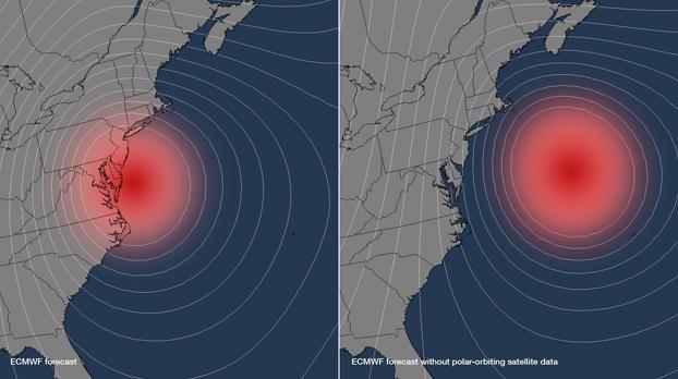
Polar-Orbiting Satellite Data Was Key To Pinpointing Sandy's Track And Time Of Landfall.
I did not realize this, but these low-orbiting (polar) satellites are
critical to initializing models with the best data available. Here's an
excerpt of an article from China National Space Administration and
Space Ref: "
According
to a new study by the European Centre for Medium-Range Weather
Forecasts (ECMWF), the NOAA forecasts of Hurricane Sandy's track could
have been hundreds of miles off without information from polar-orbiting
satellites. Rather than identifying the New Jersey landfall location
within 30 miles five-days before landfall, the models would have shown
Sandy remaining at sea. "This study shows the value of polar-orbiting
satellites in developing life-saving forecasts with longer lead times,"
said Dr. Kathryn Sullivan, assistant secretary of commerce for
environmental observation and prediction, and deputy NOAA
administrator. "Had we thought the brunt of the storm was going to stay
out in the Atlantic, or if residents had only a day to prepare or
evacuate, the results would have been even more devastating." The ECMWF
is an independent, intergovernmental organization supported by 34
European nations, providing global medium-to-extended range forecasts..."
Image credit above: "
This image uses the model output from
the ECMWF experiment, showing where Sandy was predicted to be located
five-days out with the normal satellite data inputs into the model
(left) and without any polar-orbiting satellite data (right). Both
position and intensity forecasts were affected - Sandy stays out to sea
without the polar-orbiting satellite data, and the closer isobar lines
encircling the storm also imply a more organized and stronger system."
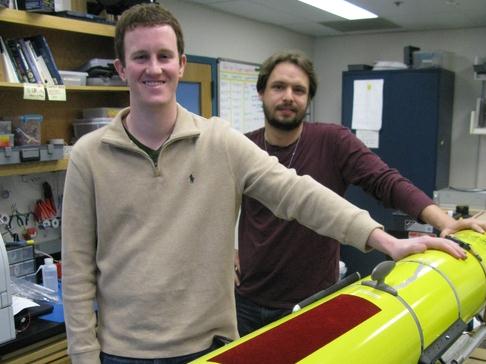
Rutgers Robot's Sandy Mission May Aid Hurricane Forecasts. Picking up on the Sandy theme, here's a snippet from an article at
The Daily Record: "
While
everyone at the Jersey Shore was putting gasoline in their cars and
tying down patio furniture the weekend before superstorm Sandy, Rutgers University graduate students Greg Seroka and Travis Miles tracked their robot
swimming around in the storm's path. In the days that followed, they
got a rare glimpse into erupting undersea conditions as the storm swept
ashore. Data the probe collected - including currents and sharp drops
in sea surface temperature - might help scientists reconstruct Sandy's
behavior and better predict how hurricanes change in the critical hours
before landfall..."
Photo credit above: "
Rutgers University graduate students
Greg Seroka, left, and Travis Miles launched a Slocum electric glider
robot probe like this one to record ocean temperatures, currents and
other information from the heart of superstorm Sandy." (Gannett, Kirk Moore - Asbury Park (N.J.) Press.
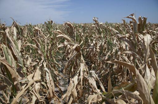
2012 Agriculture Review: Crop Production, Drought Conditions. Here's a good national recap of the crazy extremes farmers had to deal with in 2012 from
Corn and Soybean Digest. What, you don't read Corn and Soybean Digest? You should give it a try - here's an excerpt: "
As
we reach the end of the year, it is a good time to reflect on what
happened agriculturally in the region and across the United States in
2012. This will be a two-part article, with a review of 2012 crop
production and weather conditions this week, and a review of livestock
production, input costs and grain prices next week.
Crop Production
2012 will be remembered as the year of the drought,
and a crop year with weather extremes and highly variable crop
conditions in many areas of Minnesota. The year started out with
earlier-than-normal corn planting
in most of the state, with a large majority corn planted in April or
very early May. Warmer-than-normal temperatures, along with adequate
topsoil moisture, resulted in excellent crop germination and allowed the
2012 corn and soybean crop to get off to a good start. The month of
May had 150-200% of normal rainfall in much of the southern half of
Minnesota, which allowed for restoration of stored soil moisture levels
to near capacity levels in many areas..."
Photo credit above: AP/Nati Harnik.
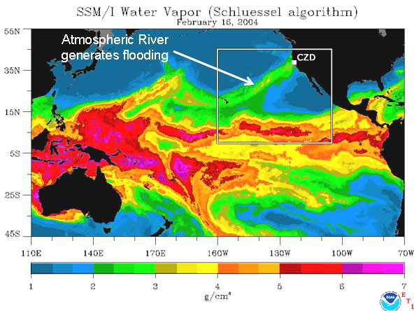
Forget Earthquakes And Tsunamis: Research Into Atmospheric Rivers Finds California's Next "Big One" May Be Megastorm. Here's a clip from a story at
The Daily Breeze that caught my eye: "
Most
North Coast residents have come to accept the likelihood of a major
earthquake or tsunami striking at any moment. But new scientific
research into powerful winter weather systems -- called atmospheric
rivers -- has revealed that California's next “big one” might actually
be a powerful rainfall event that could trigger extensive flooding and
millions of dollars in damage across the state. As the National Oceanic
and Atmospheric Association works to install four permanent
observatories to study atmospheric rivers -- one of which will be
located near Eureka -- weather scientists are hoping the new science
into atmospheric rivers may prompt the public to better prepare for the
likelihood of a wide-scale flooding event. Michael Dettinger, a
research hydrologist with the U.S. Geological Survey, co-authored a
recent Scientific American article which raised the possibility that
California might be overdue for what is being called an atmospheric
river “megastorm.”...
Image above: NOAA.
The Biggest Tech Disappointments Of 2012. I tend to agree with most of these;
Gizmodo has the honors: "
Lots
of fun, good, and exciting things happened in our world this year. But
there were still so many things that could've been truly great, but
flopped. Broken promises. Awful gadgets. Here's what broke Gizmodo's
heart in 2012."
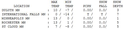
Jingle Bells Weren't Jingling. Because they were
frozen solid. It was the coldest day of the winter so far across
Minnesota, International Falls experiencing a daytime max of 0, after
waking up to -14. St. Cloud saw a low of -8, but recovered to 7 above.
Highs ranged from 3 at Alexandria to 13 Twin Cities to 21 at Grand
Marais (a "warmer" breeze off Lake Superiod). Go figure.
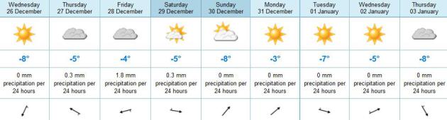
Paul's Conservation Minnesota Outlook for the Twin Cities and all of Minnesota:
TODAY: More clouds than sun. Winds: NE 10. High: 16
WEDNESDAY NIGHT: Mostly cloudy. Low: 8
THURSDAY: Intervals of sun, still quiet. High: 23
FRIDAY: Few flurries. Dusting possible. No big deal. Low: 14. High: 26
SATURDAY: Mostly cloudy, good travel weather. Low: 13. High: 23
SUNDAY: More sun, chilling breeze. Low: 8. High: 19
NEW YEAR'S EVE: Dry with some sun. Low: 12. High: 26
NEW YEAR'S DAY: More sun. Welcome 2013! Low: 7. High: 18
Climate Stories...
"
Be loyal to what you love, be true to the earth, fight your enemies with passion and laughter." - Edward Abbey
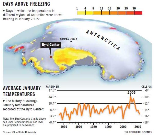
OSU Study: Antarctica A Lot Hotter Than In '58. Here's an excerpt of a story at
The Columbus Dispatch: "
New
research from Ohio State University shows that the average annual
temperature in West Antarctica has increased 4.3 degrees since 1958 —
three times faster than the global-warming trend that climatologists
have recorded. The discovery raises troubling new questions about the
future of the West Antarctic Ice Sheet, which is part of an area that is
roughly the size of Greenland. As it melts, the effect on sea levels
could be dramatic. The new results show it’s more common now for high
temperatures to surpass 32 degrees in Antarctica, something unheard of
in the past..."
Image credit: Ohio State University and The Columbus Dispatch.
Warming In West Antarctica Proves Global Warming Is Real. Here's a clip from a story at
Science Recorder: "
Increasingly
warm temperatures in West Antarctica is likely the latest sign that
global warming is here to stay, according to a team of climate
scientists. In a paper released Sunday by the journal Nature Geoscience,
Andrew J. Monaghan of the National Center for Atmospheric Research in
Boulder, Colorado, and David H. Bromwich of Ohio State University,
note that a recent analysis of the Antarctic Peninsula shows it is
warming significantly faster than other regions around the world.
According to their analysis, temperatures at a research station in West
Antarctica have warmed by 4.4 degrees Fahrenheit since 1958 — roughly
twice the rate predicted by climate scientists..."
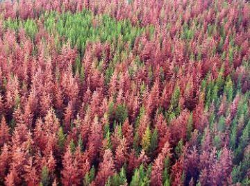
Warming Alaska Interior Forcing Some Trees To Slowly Migrate Across State. Details from
The Alaska Dispatch: "
In
almost every patch of Interior Alaska boreal forest that Glenn Juday
has studied since the 1980s, at least one quarter of the aspen, white
spruce and birch trees are dead. “These are mature forest stands that
were established 120 to 200 years ago,” said Juday, a professor of
forest ecology at the University of Alaska Fairbanks’ School of Natural
Resources and Agricultural Sciences. “Big holes have appeared in the
stands.” At his presentation during the Fall Meeting of the American
Geophysical Union held in San Francisco earlier this month, Juday spoke
of a “biome shift” now underway in Alaska — the boreal forest is
suffering in the Interior and flourishing in western Alaska..."


No comments:
Post a Comment