18 F. high in the Twin Cities Monday.
25 F. average high for December 24.
42 F. high on December 24, 2011.
1" snow on the ground in the Twin Cities (at least at MSP International, where all things official take place).
Christmas Magic
"Christmas waves a magic wand over this world, and behold, everything is softer and more beautiful" wrote Norman Vincent Peale.
Science has its limits. It rarely captures the
true wonders of the universe, and will never unwrap the mysteries of
enduring faith. Science has its place, but Christmas reminds us we
believe in things we can't measure or observe. Bigger, far more
important things.
My jingle bells are frozen, but at least the sun
is out. No freak snow or ice storms are brewing, looking out 2 weeks.
Yes, we're in a drought. My hunch: The period through January 2 will be
one of the colder weeks of winter; what I suspect will be a compressed,
somewhat abbreviated winter for Minnesota.
After waking up near zero this morning today's
"high" may hold in single digits. 20s will feel like a blessing by the
end of this week, then colder again for the first few days of 2013. No
records, hardly bitter, and this cold dome a). keeps the sun out, and
b). shoves the storm track well south of MSP. I already see signs of a
January Thaw.
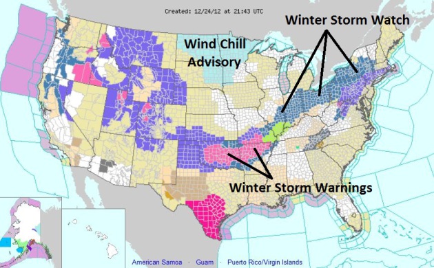
Traveling tomorrow? Big snows are likely from
Little Rock to Cleveland & Syracuse - windswept rain for New York
City. Check the blog below for details.
A Chilly, Dry Week.
No weather drama expected through the first few days of January; a
slight warming trend by the end of the week - another clipper drags a
fresh infusion of (fresh) air into Minnesota by Sunday, highs stuck in
the teens the first few day sof 2013. ECMWF forecast data above.
Christmas Day Weather Story. Merry Christmas!
Welcome to the coldest day of winter (so far) with highs struggling to
nick 10 above. At least the sun will be out. This is about as chilly as
its going to get - 20s returning by the end of the week. Big shock: no
accumulating snow is in sight looking out 2 weeks. If your travels take
you into the Ohio Valley or East Coast you will run into foul weather
tomorrow and Thursday; a swath of heavy snow from Little Rock to
Cleveland and Syracuse, a few tornadoes over the Deep South (today) and
heavy, windswept rain (and severe storms) from Atlanta to D.C. tomorrow,
minor flooding may spread into New York City and New England Wednesday,
mixing with snow inland before tapering. The cold is annoying, but for
the near term all this Canadian air will inoculate us from major storms.
A small price to pay.
Travel Update Wednesday- Thursday. I prepared the
briefing below for our corporate clients; wanted to share it with you.
No problems across the Upper Midwest, but this latest push of Canadian
air will whip up a band of heavy snow, a few tornadoes over the Deep
South, and a wind/rain storm out east capable of minor flooding and even
a few power outages by Wednesday night. NOAA has the latest details on
this
clickable, interactive map. Details:
This storm will affect major population centers of the Northeast (including New York City)
with very heavy rain and high winds Wednesday; the peak of the storm
coming Wednesday evening, when winds gust to 50 mph and heavy rain
creates minor flash flooding risks and sporadic power outages. I
expect the storm to impact metro New York travel Wednesday PM, snarling
commutes and leading to delays and possible cancellations at LGA, EWR and JFK.
Farther inland heavy snow is likely from Little Rock to Cleveland, with some 15-20" snowfall amounts possible from upstate Pennsylvania to Buffalo, Rochester, Syracuse and Albany by Thursday. No accumulating snow is expected from D.C. to Philadelphia and New York.
Christmas Day Tornado Outbreak? Meteorological ingredients are converging for possible tornadoes tomorrow, from near New Orleans to Jackson and Montgomery. An enhanced risk of damaging thunderstorms exists from Birmingham and Huntsville to Mobile, Pensacola and Atlanta.
I realize that offices are closed tomorrow, but precautions should be
considered for facilities within the "moderate risk" (red) zone, where
the threat of tornadoes is greatest.
Wednesday Severe Storm Risk. The risk of large, violent tornadoes diminishes (slightly) by Wednesday, but a few severe thunderstorms from Macon and Charleston to Raleigh and the Tidewater region of Virginia may see damaging winds and isolated tornadoes Wednesday afternoon.
High Wind Potential Wednesday.
Some of our weather models are suggesting winds in the 30-50 mph range
Wednesday PM hours, capable of minor damage and potential power outages
for the Northeast. Right now the risk of major storm surge flooding for
coastal New Jersey and New York appears quite small - the storm is
moving too quickly to churn up a major surge.
Peak Of The Storm. One silver lining: the storm is moving quickly, but I expect heavy rain, high winds, and possible thunderstorms from the Delaware Valley into New York City by Wednesday evening/night, capable of minor flooding of poor drainage areas and light wind damage.
Significant Snows.
Although no accumulating snow is expected for major population centers
from D.C. to New York to Boston, as much as 12-20" of snow may
accumulate from Altoona and State College, PA northward to Buffalo, Rochester, Syracuse and Albany. As much as 10-12" may impact Cleveland and Toledo, closer to 6" for Columbus.
Summary: We're
tracking a potential Christmas Day tornado outbreak for the Deep South
(Louisiana and Mississippi most impacted), but this storm will be
pushing up the East Coast Wednesday with strong/severe T-storms, heavy
rains and high winds. Expect maximum impact Wednesday PM hours, with
conditions improving Thursday. Heavy snows may temporarily disrupt
operations from Little Rock (10" snow) into the Ohio Valley, portions of Pennsylvania, upstate New York and interior New England.
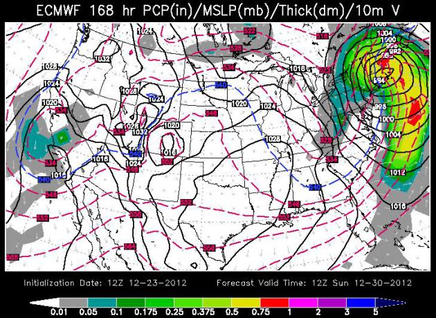
Weather Trends: Storms Buffeting Deep South and East Coast.
The ECMWF model above, valid Sunday morning (WSI) shows yet another
storm sweeping up the east coast, mostly rain for the major population
centers, but a changeover to heavy wet snow over New England. Boston may
pick up a few inches of wet snow from the system next Sunday/Monday,
while Minnesota warms up to near freezing.
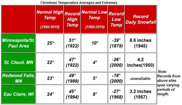
Christmas Numbers.
The average high for Christmas Day is in the low to mid 20s across
most of southern and central Minnesota. Climate info courtesy of the
Twin Cities
National Weather Service.
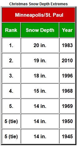
Very White Christmases. NWS historical data shows a whopping 20" on the ground back in 1983, 19" as recently as 2010.
Biggest Minnesota Weather Stories of 2012? Here is an excerpt from a recent post by Greg Spoden and Pete Boulay at
The Minnesota Climatology Working Group:
#5 Non-Winter of 2011-12
Some of the predictions were dire. Possibly a winter more snowy than
2010-2011 was in the cards. It didn't happen. One of the most wimpy
winters ever seen in the Twin Cities and Minnesota was the result with
mild temperatures and scant snowfall. 2011-12 wound up the tenth
least snowy winter on record for the Twin Cities and was the fourth
warmest winter on record.
#4 Hot July 2012
2012 was the second warmest month ever for the Twin Cities back to
1872 with 80.2 degrees. Only July 1936 was warmer with 81.4 degrees.
Duluth had its warmest July on record, although in 1936, the recording
station for Duluth was closer to Lake Superior. To escape the heat,
one had to go to International Falls where the average July
temperature was 69 degrees making 2012 only the 12th warmest July on
record there.
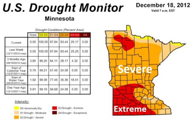
#3 Drought of 2011-2012
This could easily be #1 depending on where you live in Minnesota. The
heavy rains of May and June, 2012 helped to blunt the drought a
bit, but then it intensified by the late summer and continued into
the fall. By late November 80% of the state was under a severe or
extreme drought. By fall, soil moisture levels at the University of
Minnesota Southern Research and Outreach Center in Waseca were some
of the lowest on record.
#2 Northeast Minnesota Flood of June 19-20
The largest flash flood event in Minnesota for 2012 struck northeast
Minnesota on June 19-20. The largest two day total was 10.10 inches
just northeast of Duluth. There were so many roads flooded out in
Carlton County that the county rain out of signs and more had to be
trucked from the Twin Cities. One of the iconic photos of the storm was
of Feisty the seal who escaped the Lake Superior Zoo and wound up on
a neighborhood street. The St. Louis River engulfed and nearly
destroyed the Jay Cooke State Park Swinging Bridge, but it will reopen
in the summer of 2013. As for Feisty? She found refuge at Como Zoo
and now has over 800 followers on
Twitter.
#1 Outrageously Mild March 2012
Imagine if you will a March that was so warm it would break six
record high temperature records in the Twin Cities, have four days with
muggy dew point temperatures that reached 60 and wound up warmer
than October! To top it off the Twin Cities had its earliest 80
degree temperature ever with 80 degrees on St. Patrick's Day, March
17. The old record was March 23 back in 1910. March 2012 will go down
in history as one of the most bizarre months temperature-wise,
finishing 15.5 degrees above normal. The only other month in the
historical record for the Twin Cities that matches this feat was
January 2006 that also finished 15.5 degrees above normal. As a
consequence, spring phenology was exceedingly early with lilacs
blooming the earliest on record in the Twin Cities, with many in full
bloom by mid April.
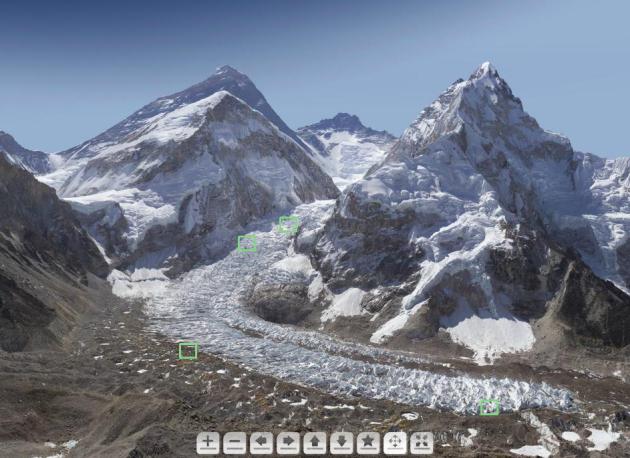
 A 3.8 Billion-Pixel Tour Of Mt. Everest
. This is pretty amazing; definitely worth a look. Here's an excerpt from
NPR: "
Photographer David Breashears of GlacierWorks
was on All Things Considered Monday to talk about a new way of
photographing the Himalayan region: By stitching together 400-plus
images into one giant, zoomable, interactive image — or a "gigapan"
containing more than a billion pixels. He and his team just sent us
something even cooler that they're currently working on: a Mount Everest you can explore, containing an estimated 3.8 billion pixels!"
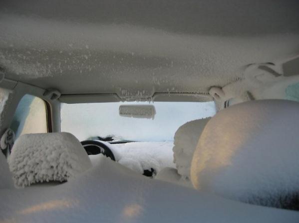
Nice Interior Trim. Thanks to airjokeroo.com for passing this one along. Looks like someone forgot to roll up their windows. Ouch.
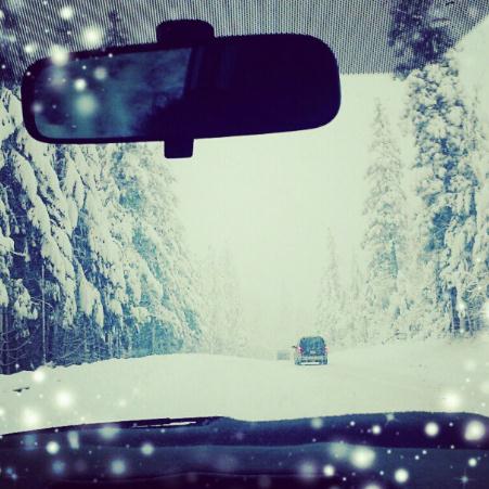
Snowy Magic. This photo was taken on Monday near Truckee, California - courtesy of WeatherNation TV.
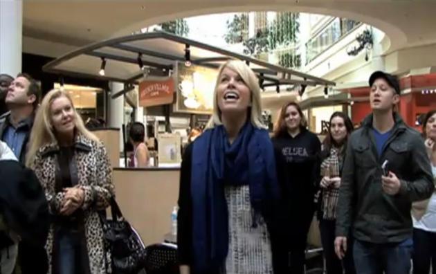
The Real Spirit of Christmas. It's easy to get
caught up in your "December Bubble", running around, focusing on gifts,
relatives, cooking, reunions. You should check out this
YouTube clip, apparently shot at the Mall of America recently. If you don't have the holiday spirit - you will after watching this.
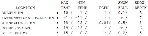
 Nippy Christmas Eve
.
Yes, it was brisk out there, a dusting of morning flakes giving way to
some afternoon sunshine. Highs ranged from -1 at International Falls to
15 St. Cloud and 19 in the Twin Cities.
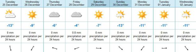
Paul's Conservation Minnesota Outlook for the Twin Cities and all of Minnesota:
CHRISTMAS DAY: Santa needs a hug. Cold sun. Winds: NW 10. High: near 10
TUESDAY NIGHT: Mostly clear, a bit nippy. Low: 0
WEDNESDAY: Patchy clouds, still brisk. High: 16
THURSDAY: Clouds increase, not as cold. Low: 9. High: 21
FRIDAY: Mostly gray, few flakes - probably no accumulation. Low: 13. High: 24
SATURDAY: Mix of clouds and sun. Low: 11. High: 22
SUNDAY: Blue sky, lack of kinetic energy. Low: 7. High: 18
NEW YEAR'S EVE: Cold, dry New Year's Eve parties. Low: 3. High: 16
Climate Stories...
Climate Change Is Big Business (For The Insurance Industry). The world's largest industry is taking climate change very seriously. Here's an excerpt of a story at
arstechnica.com that caught my eye: "
Although
many industries have fought to prevent action on climate change,
there's at least one major business that's taking it seriously,
according to a recent perspective in Science. Climate change is
estimated to cost the world economy $1.2 trillion annually, which is
proving to be a stress test for the insurance industry. Lest you think
that's a niche concern, insurance accounts for seven percent of the
global economy and is the world’s largest industry. Increasingly,
weather and climate related catastrophes are costing insurers. The
number of weather-related loss events in North America has nearly
quintupled in the past three decades, according to a recent report from
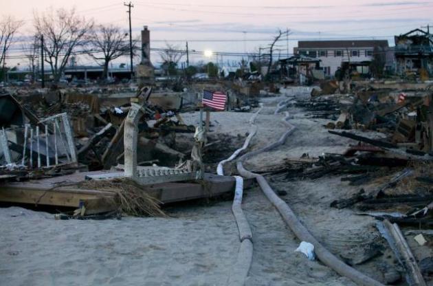
MunichRe. Sandy alone cost New York and New Jersey $80 billion,
affecting individuals and business, and impacting health. Claims have
more than doubled each decade since the 1980s (adjusted for inflation)
and paid claims now average $50 billion a year worldwide...." (Photo: Allie Wilkinson).
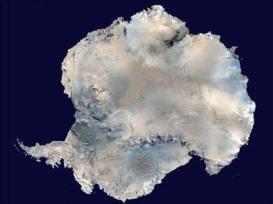
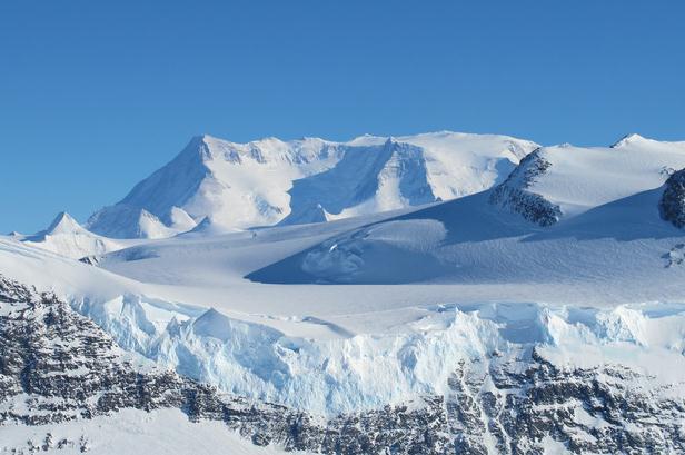
Western Antarctic Warming Confirmed. Contrary to the climate denier meme that "Antarctica is getting colder!"
USA Today reports; here's an excerpt: "
Western
Antarctica has warmed unexpectedly fast over the last five decades,
weather records confirm, adding to sea-level rise concerns in a warming
world. Temperatures in West Antarctica have increased at a rate nearly
twiceas large as the global average, a 4.3 degree Fahrenheit increase
since 1958, conclude meteorologists in the journal, Nature Geoscience,
out Sunday.The finding adds Western Antarctica to the list of hot
spots most affected by global warming, the century-long increase in
global average temperatures largely driven by greenhouse gas emissions
from burning oil, gas and coal..."
Scientists Report Faster Warming In Antarctica.
The New York Times has the story; here's an excerpt: "
West Antarctica has warmed much more than scientists had thought over the last half century, new research
suggests, an ominous finding given that the huge ice sheet there may
be vulnerable to long-term collapse, with potentially drastic effects
on sea levels. A paper released Sunday by the journal Nature Geoscience
reports that the temperature at a research station in the middle of
West Antarctica has warmed by 4.4 degrees Fahrenheit since 1958. That
is roughly twice as much as scientists previously thought and three
times the overall rate of global warming, making central West Antarctica one of the fastest-warming regions on earth..." (Photo: James Yungel, NASA).
Harvard Scientist Proposes Refreezing Arctic To Prevent Global Warming Disaster. Not sure this is a great idea - I hope we never reach the point where this is deemed a necessity.
Mashable reports; here's an excerpt: "
Harvard
University geoengineer and environmental scientist David Keith has a
"plan B" in case of an environmental emergency. Keith's unusual proposal
is this: Force reflective particles into the Earth's upper atmosphere
-- the stratosphere -- to reverse global warming. "One approach is to
disperse particulates at high altitude to reduce the effective solar
flux entering the atmosphere," Keith and his fellow researchers report
in the Nature Climate Change journal and Environmental Research Letters..."
Image above:
coolsydney.net.au.
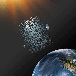
Texas Bird Count Gives Scientists Alarming Climate Change Clues.
Huffington Post has the story - here's an excerpt: "...
Similar
changes in bird behavior could be seen this year in the Midwest and
parts of the South, areas that have been gripped by a massive drought
that covered two-thirds of the nation at its height. The drought's
severity is unusual, but scientists warn that such weather could become
more common with global warming. Birds — as well as other animals —
will have to adapt, and the data collected in the Christmas count gives
crucial insight on how they might do that. The dataset is notable for
its size and the decades that it covers. Along with showing how birds
adapt to climate change, it reveals the impact of environmental
changes, such as habitat loss, which has contributed to a 40 percent
decline in bird numbers during the past 40 years, said Gary Langham,
vice president and chief scientist for the National Audubon Society..." (Photo above: AP)
"...America's contributions to global climate change and our oil
dependence are endangering our national security, our economy and our
environment. But the global climate crisis is more than an urgent
scientific emperative; it is also a tremendous economic opportunity to
secure America's leadership in creating the low-carbon global economy
and our future prosperity..."
- Senator Bob Kerry, quoted in an article at
Ars Technica. Image: Wikipedia.
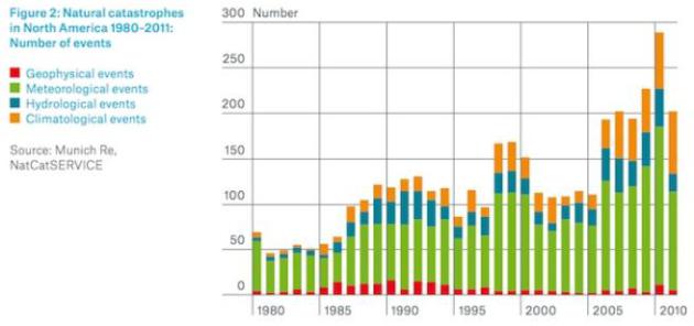
Troubling Trends. 14 separate billion dollar weather disasters in 2011, at least 11 more in 2012. Graph: Munich Re and NatCatSERvice.
With Climate Change, Winter Isn't What It used To Be. Here's an excerpt of an article at
The Seattle Times: "...
One
of the biggest surprises in the technical report on biodiversity and
ecosystems is how much winter has already changed, said Bruce Stein,
director of climate-change adaptation with the National Wildlife
Federation, in a conference call this week. "The bottom line is that
these impacts aren't just going to happen in 50 to 100 years; many of
them are already here, and are only going to get worse over time,"
Stein said. "There has already been more effect on winter than we
thought, and that affects what happens in summer." In the Northwest,
forests already show the effect of warmer winters in beetle-killed
trees. The pests thrive without the killing cold. That, in turn, means
summertime wildfires stoked with dead conifers..."
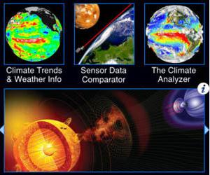
An Apps-Eye View Of Global Warming And Climate Change. Here is an excerpt of a good review of a few climate change related apps you can download for IOS and Android from
MercuryNews.com: "
Drought
in the Midwest; forest fires in the Southwest; blizzards and
hurricanes on the East Coast; rising ocean levels on both coasts. If
you're wondering what to make of the crazy weather of the past few
years, maybe it's time to check out some of the iPhone and Android apps
you can use to study climate change and global warming. Quite a few
are devoted to the still-contentious issue. Many are for the Apple (AAPL)
operating system, but there are some in the Android app store too. By
making the science visual, some of these apps let the
nonprofessional see historic trends without having to wade through
thousands of spreadsheets and databases..."


No comments:
Post a Comment