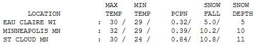
32 F. high yesterday in the Twin Cities.
29 F. average high for December 9.
17 F. high on December 9, 2011.
10.2" snow fell as of 7 pm yesterday at MSP
International, a new snowfall record for December 9. The old record was
7.4" on December 9, 1961.
Winning the Snow Lotto
Snow lovers are joyous, like a little kid with a new puppy at Christmas. Commuters? Not so much.
What happened? How did predicted snowfall amounts DOUBLE in the span of 12 hours Saturday?
Every storm is unique; there's no such thing as
an identical storm. Every scenario is different, unique. Early Saturday
it appeared the axis of heaviest snow would set up from Alexandria to
Brainerd and Duluth. But PM model runs kept shifting the smear of
heaviest snow ("deformation zone") farther south and east, running right
over the metro area. There was enough upward motion (vertical velocity)
for a sustained burst of moderate to heavy snow; temperatures just cold
enough for all snow.
I've discovered (the hard way) that it pays to
be skeptical about snow amounts. I'm always amazed the multitude of ways
Mother Nature can cheat us out of snow.
Every storm is uniquely humbling.
Not this time - it was the most snow in nearly 2
years for much of the metro. And it's not going anywhere soon. A
numbing Monday (wind chill dipping to -15 F gives way to 32 F by
midweek. I don't see any significant melting between now and a very
white Christmas. In fact a few more inches may fall next Saturday. Like
turning on a switch. Instant winter!
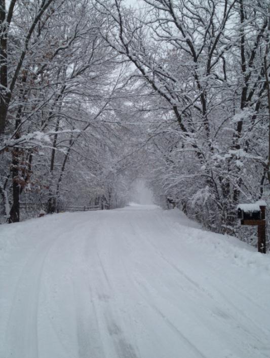
* photo above from Diane Baum, who snapped this photo up in Zimmerman.
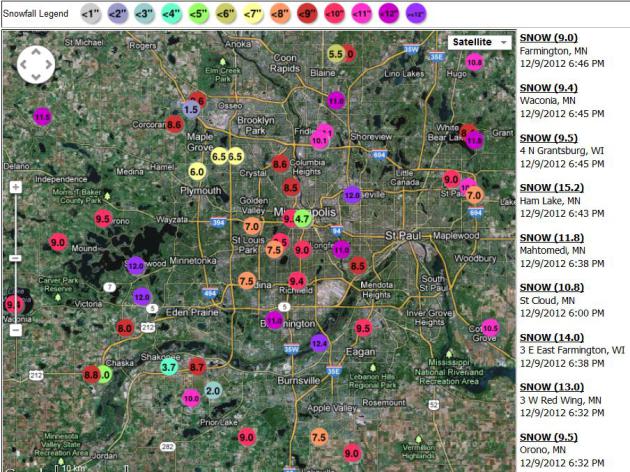
Impressive Amounts. Roseville, Inver Grove Heights,
Chanhassen and Shorewood all reported a foot of snow as of Sunday
evening - most metro locations in the 6-10" range. Yes, our snow drought
is over, a nearly 11.5" snowfall deficit since late September erased
with a single storm. To zoom into your county or town to get updated
snowfall totals from the Twin Cities NWS office
click here.
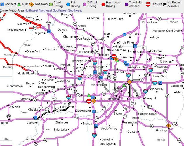 Current Travel Conditions
.
Before leaving the house (early?) this morning you may want to check
out 511mn.org, MnDOT's official web site, with information for the
Twin Cities metro and
greater Minnesota.
Even though the accumulating snow is over, temperatures in single
digits will make it nearly impossible to melt a pesky layer of ice.
Chemicals don't work nearly as efficiently when it's colder than 15 F.
Commute times may be double, or longer, a slightly better drive home
this afternoon.
Winter Wonderland. How did expected snowfall amounts
double in the span of 24 hours? Every storm is different, and this one
was especially fickle, for a number of reasons. Usually a thick layer of
cold air needs to be in place for a major snowfall. We didn't have that
with this storm, temperatures aloft fairly close to freezing this
morning. But the upward motion, the vertical velocities associated with
this storm are unusually intense. Not only does this create moderate to
heavy snow, but strong upward motion cools the column of air overhead,
preventing a changeover to ice or rain, which would keep final amounts
down. Saturday morning is still looked like the axis of heaviest snow
would set up from near Alexandria and Willmar to Little Falls, Brainerd
and the North Shore of Lake Superior. By afternoon models were shifting
that axis from southwest-northeast, to a more west-east configuration,
stretching from Willmar to the Twin Cities to Baldwin, WI. Yes, every
weather scenario is fluid - this one surprised me a little. I realize
the snow is a hardship, a bummer for many people. All it takes is one
good fall on ice to ruin your winter (or worse). I get it. But you live
in Minnesota - where snow is part of the landscape (some winters). If
you don't like it, be patient - this too shall melt (although no time
soon, certainly not before Christmas). No big thaws looking out 2 weeks.
If you happen to like snow - congratulations. We all just won
Minnesota's Snow Lotto.
For once.
** thanks to my friend Heidi Rusch for the photo above, taken in
front of her house in Minnetonka. Yes, it really is beautiful out there
right now, with snow sticking (to everything - including my dog).
A Very Respectable Snowman. Thanks to Charles Strinz (and family) - who hand-assembled a fine snowman in Eagan Sunday afternoon.
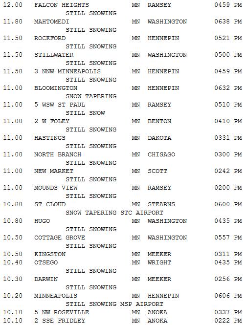
Snowfall Totals. 17.3" at Sacred Heart, unofficial
winner of the coveted Golden Snow Shovel Award. Ham Lake picked up 15",
with 13" at Anoka. MSP International had picked up just over 10" as of 6
pm, most metro locations seeing anywhere from 7-12" of snow. The latest
observed snowfall amounts are
here, courtesy of the National Weather Service.
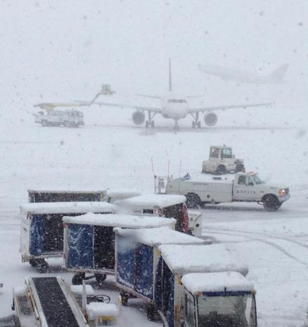
Testing The De-Icing Equipment. Yes, there were some
delays and cancellations yesterday. Any other airport in the USA would
have pretty much shut down after 10-11" of snow. Not MSP International. I
was there - and frankly amazed with how smooth things were running at
the height of the storm. Impressive. Photo: Deena Randolph.
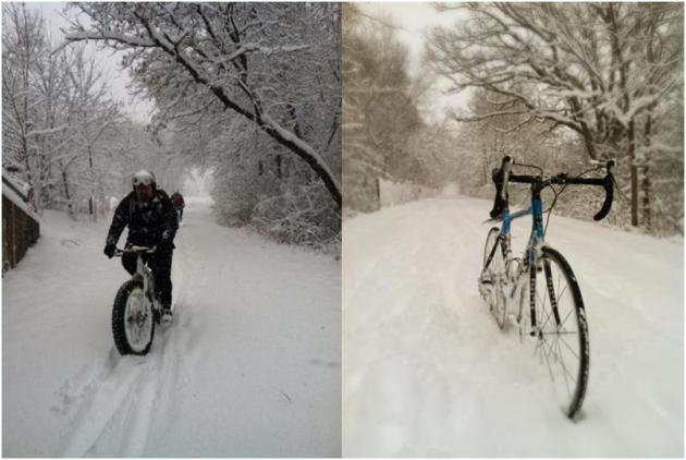
Good Biking Weather. That's Jason Gust (upper left) -
not letting snow slow down a little fat-bike-riding. Thanks to
WeatherNation TV meteorologist Todd Nelson for sending that one in.
Steve Burns sent me the pic in the upper right - a snowy kick-stand?
Nice.
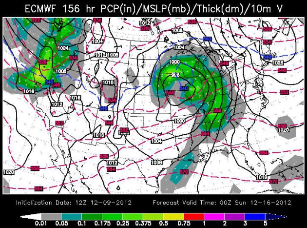
Snowy Mix Saturday? It's early - things will almost
certainly change over the next 5 days as new data comes in, but the
ECMWF forecast for Saturday evening shows the "540 line", the
approximate rain-snow line, very close to MSP. Another southern storm
may leave us with snow mixing with sleet or even rain by late in the day
Saturday. A light, slushy accumulation is possible Saturday - I doubt
we'll see anything to rival yesterday's snowy dumping. 00z Sunday
outlook above courtesy of WSI.
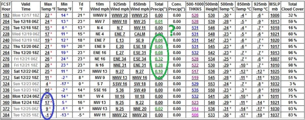
Fairly Safe Bet: A White Christmas. Although highs
may brush 32 F. by midweek I don't see any extended thaws over the next 2
weeks. Most of the snow in your yard now will still be there for
Christmas. In fact the GFS solution (above) is hinting at another storm
December 20-22. We'll see. Highs may reach the 20s Christmas Eve, but
the long (long!) range outlook for Christmas Day calls for highs in the
teens; lows may dip below zero. Santa will need his Thinsulate.
Instant Winter. We went from snow drought to nearly a
foot of snow, in the span of 24 hours. As of 7 pm 10.2" had fallen in
the cities, 10.8" at St. Cloud. Sunday highs ranged from 28 at
Alexandria to 30 St. Cloud, 32 Twin Cities and 33 at Redwood Falls.
“Faith is to believe what we cannot see, and the reward of this faith is to see what we believe.” - Augustine
Paul's Conservation Minnesota Outlook for the Twin Cities and all of Minnesota:
TODAY: Numbing sunshine. Coldest day yet. Wind chill: -10. Winds: NW 10. High: 10
MONDAY NIGHT: Mostly clear, bordering on bitter. Low: 6
TUESDAY: Partly sunny, not as cold. High: 23
WEDNESDAY: More clouds, a bit "milder". Low: 14. High: 31
THURSDAY: More clouds than sun, feeling a little better out there. Low: 16. High: 32
FRIDAY: Sunny start, clouds increase. Low: 19. High: 29
SATURDAY: More wet snow, possibly mixing with sleet or rain. Low: 20. High: 28
SUNDAY: Flurries taper, clouds linger. Low: 17. High: 26


No comments:
Post a Comment