20 F. high in the Twin Cities Monday (around midnight). The afternoon high was 17, but readings dropped to +2 F. by 9 pm.
29 F. average high for December 10.
27 F. high on December 10, 2011.
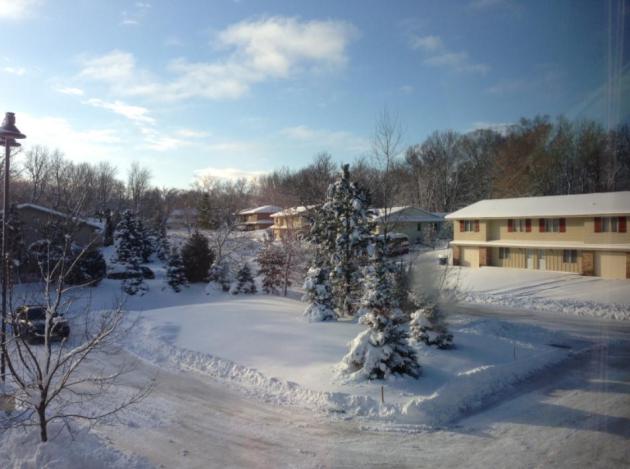
9" snow on the ground in the Twin Cities Monday.
Pro Snow?
So much for our snow drought. Yet 83 percent of
Minnesota is still in severe drought, or worse. Sunday's 8-14" storm,
the equivalent of turning on a snowy faucet, can't hurt, but early
spring rains will determine if we can salvage a promising growing season
in 2013. All or nothing.
After last winter's (pathetic) 22 inches I was
exuberant about the weekend snow-blitz. Some took me to task over a
"pro-snow" bias, pointing out the risk of traffic accidents &
injuries and seniors falling on icy sidewalks. I get it. And I'm
certainly not insensitive to the very serious problems that a big
dumping of snow can trigger. Winter is a blessing and a curse. But we
live in Minnesota. Snow is part of our DNA. It's a little like growing
up in San Diego and complaining about the ocean.
Yes, everyone has an opinion about the weather.
Santa is pleased: no long-lasting thaws are
brewing for the next two weeks. In fact this is as cold as it's going to
get for the next 10-15 days; highs mostly 20s and low 30s. We may hit
40F the weekend before Christmas, but most of the snow in your yard will
still be there on Dec. 25.
Details below: today the sun starts setting
later, due to the changing speed of Earth as it reaches its closest
point to the sun. By Dec. 31 the sun sets 10 minutes later than now!
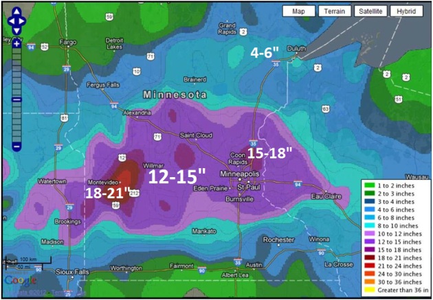
How Much Fell? Yes, it was a lot more than most of
us were thinking back on Friday. By midday Saturday models were
(finally) shifting the heaviest axis of snow from Montevideo and Willmar
into the Twin CIties metro. Not much lead time with this one. The local
National Weather Service has a good map showing snow totals
here.
* a whopping 13.6" of snow fell at
Twin Cities Headquarters in Chanhassen, Minnesota! 10.5" fell at MSP Airport.
* for much of central and southern Minnesota it was a "December's worth" of snow, falling in 24 hours or so.
* 4th largest December snow storm in modern-day Twin Cities weather records.
* keep in mind a total of 22.3" of snow fell last winter. The most from a single storm? 4.2" on December 3, 2011.
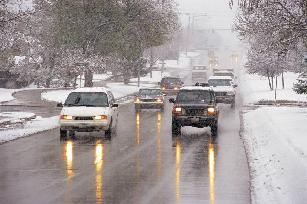
Temperature Matters. O.K. We picked up a healthy
8-14" of snow, but temperature was also a big factor after the storm.
Keep in mind that temperatures colder than 10-15 F. make it very
difficult for chemicals/sand to melt snow. A snow storm at 10 F. is far
more dangerous (on the highways) than a storm at 25-30 F, when it's
still possible to melt snow and ice and have (mostly) wet highway
surfaces. It's not just the amount of snow, but the air temperature that
determines how nasty the roads will be. Photo: NOAA.
Did Sunday's Snow Help Our Drought Situation? I posed
this question to Minnesota's State Climatologist, Greg Spoden. Here is
his response: "The snow storm will have some impact on drought
conditions. Three-quarters of an inch, to one and one-quarter inches of
precipitation, falling along a 125-mile-wide swath of Minnesota's
drought-stricken landscape is, of course, very welcome. In many locales,
the weekend precipitation totals were roughly the equivalent of
December's normal
monthly precipitation total. For quite a few places, 24-hour precipitation totals were the largest for a single day since July.
Bad news:
- Falling upon a mostly frozen landscape, only a portion of the
weekly precipitation will enter the soil profile. Soil moisture content
in many Minnesota counties was 4-6" short of the end-of-season
historical average. This is a lot of ground to make up. Winter
precipitation alone can't rescue us. We remain very dependent on
abundant early-spring rainfall.
- The storm provided only a glancing blow to northwest Minnesota and
the southern tier of Minnesota counties, two areas of MInnesota in the
Extreme Drought category.
Good news:
- If we can retain this snow cover through the heart of winter, the
insulating effect of the snow will keep frost depths shallow. A shallow
frost leaves the ground quicer in the late-winter, thus leaving the
soils more receptive to infiltration (from rain) in the early spring.
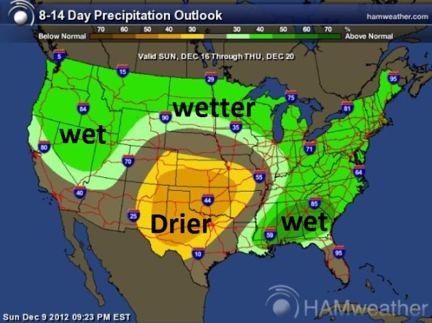
- I see that the CPC long-range outlooks (6 to 10 day, 8 to 14 day)
tilt towards above-normal precipitation. Will our high-albedo landscape
set up a baroclinic zone and thus impact the storm tracks? I'll defer to
you synopticians.
Greg Spoden, State Climatologist
Minnesota Department of Natural Resources - Division of Ecological and Water Resources
* Climate Prediction Center 8-14 day precipitation outlook above courtesy of
Ham Weather. Thanks Greg.
Sun Setting Later? I did a double-take when I got
this e-mail from consulting meteorologist Dean DeHarpporte in Eden
Prairie, but I suspect he's onto something here: "
We just got our
first taste of real winter, and the beginning of astronomical winter
(which is meaningful only for those who live their telescopes) is less
than 2 weeks away. Yet, we are very close to the first harbinger of
spring! What? Yes, on Tuesday, Dec. 11, the sun will start setting later
every day until the end of June. The reason for this happy happening is
complicated, having to do with the changing speed of the Earth as it
gets closest to the sun. Who cares why? Let's take heart from the news
that our dark evenings will soon begin to brighten - and by the end of
the month the sun will be setting a full ten minutes later than it is
now."
Thanks Dean! I needed that. See for yourself at
this web site
(plug in Minneapolis and you can get a custom calendar with
astronomical information for any month). Sunset today is 4:32 pm. By the
end of December sunset is 4:41.
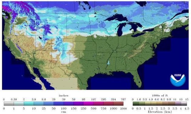
U.S. Snow Cover. As of Monday 31.9% of the Lower 48
States had snow on the ground, up from 20.6% on November 10. There's
some truth to the old adage that "snow breeds more snow". The
reason? Snow cools the air above, keeping temperatures at least 10-15 F.
cooler than they would be otherwise, which often tips (future) storms
over from a sloppy mix to snow. The process can feed on itself. It
remains to be seen if we'll see a treadmill of significant snow storms
(don't see it yet), but the way our weather has been lately - count on
anything. Map above:
NOAA.
Warming Trend. Monday was as cold as it's probably
going to get, looking out into the third week of December. Today will
still be "chilly", highs struggling to top 20, but you'll be amazed how
good 32 F. feels on Wednesday. The ECMWF (European) guidance above shows
a couple inches of sloppy snow on Saturday - temperatures aloft may be
warm enough for a rain/snow mix.
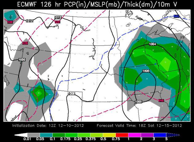
Another Southern Storm? The ECMWF guidance, valid
18z Saturday, shows a storm over Iowa throwing a shield of moisture into
Minnesota and Wisconsin. Temperatures aloft may be marginally warm
enough for snow to mix with sleet, even rain over southeastern Minnesota
- too early to tell. But no, right now I do not see a repeat of last
Sunday. Map: WSI.
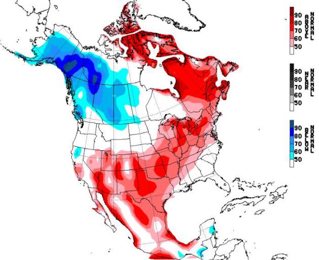
Slight Warm Bias. NOAA CPC's experimental NAEFS
long-range climate product shows a warm bias across much of the USA and
eastern Canada from December 18-24. Will we lose some of our
(precious) snow cover? Count on it. But with a little luck we may still
salvage a white Christmas. That's more of a hope than a forecast, by the
way.
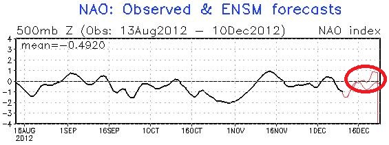
Positive NAO. The North Atlantic Oscillation, a
blocking pattern over North America, is forecast to become positive
again during the third week of December, implying a warming trend for
much of the USA - the coldest Canadian air bottled up north of the
border, at least temporarily. Graph: NOAA.
Unbelievably Poor Choices. "Hey Paul. I saw a young
lady driving on 494 in Bloomington Sunday morning. No headlights on,
rear window covered in snow AND TEXTING!!! Could you remind people to
turn ON their headlights and clear their own personal blizzard from the
vehicle BEFORE entering and driving. It is state law that your vehicle
lights must be “on” while there is any kind of precipitation falling. It
is because you will become more visible to other motorists. Drive
smarter and safer this winter."
Thank you,
Kent Smith in Eden Prairie
Amen brother. Thanks for sharing this Kent.
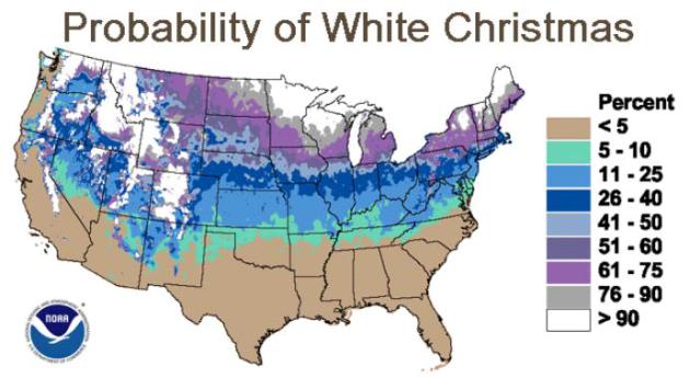
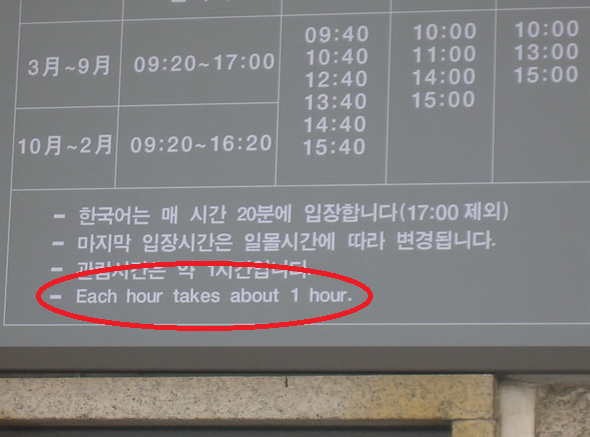
Odds Of A White Christmas. Here's an informative post from
NOAA and NCDC, highlighting those lucky towns in the USA where snow on December 25 is pretty much a forgone conclusion: "
Will
we have a white Christmas? It's an age-old question that occurs to
almost everyone this time of year. This report, created by the National
Climatic Data Center (NCDC), contains maps and tables showing the
percent probabilities for a snow depth of at least 1 inch on Christmas
morning, as well as the probabilities for a depth of at least 5 inches
and 10 inches. The "First Order" Summary of Day Dataset for the period
of 1961-1990 was used to compute these statistics. Only stations with
at least 25 years of data were used and the '61-'90 period was chosen
to coincide with the standard period for computing climatological
normals. Discussion Following is a brief summary of our findings:
Greatest probability for at least 1-inch snow depth (continental U.S.):
100% -
Marquette MI
Sault Ste Marie MI
Hibbing MN
International Falls MN
Stampede Pass WA
Greatest probability for at least 5-inch snow depth (continental U.S.): 100% - Stampede Pass WA."
December 25. Probability of... 1" 5" 10"
| ALEXANDRIA |
89% |
41% |
11% |
|
| DULUTH |
97% |
63% |
43% |
WISCONSIN |
| HIBBING |
100% |
66% |
41% |
|
| INTERNATIONAL FALLS |
100% |
73% |
53% |
EAU CLAIRE |
87% |
33% |
17% |
| MINNEAPOLIS |
73% |
30% |
13% |
GREEN BAY |
77% |
40% |
3% |
| REDWOOD FALLS |
62% |
27% |
8% |
LA CROSSE |
66% |
28% |
10% |
| ST CLOUD |
73% |
37% |
10% |
MADISON |
67% |
20% |
7% |
| |
MILWAUKEE |
60% |
10% |
3% | |
"Hurricane Sandy Was Not An Extreme Black Swan Hurricane".
Sandy was bad enough, but by no means a worst-case scenario. Here's an
interesting perspective, courtesy of Weather Underground's chief guru,
Dr. Jeff Masters: "
I was in San Francisco last week for the annual Fall Meeting of the American Geophysical Union (AGU),
the world's largest gathering of Earth Scientists. Over twenty
thousand scientists from all over the world, including many of the
world's top climate scientists and hurricane scientists, were in town
to exchange ideas to advance the cause of Earth Science. One of the
more intriguing talks was given by Ning Lin, a professor at Princeton
University. She and Dr. Kerry Emanuel of MIT are studying "Black
Swans"--tropical cyclones that are a surprise to the observer, and
cannot be anticipated based on the 162-year historical record. Very
rare extreme hurricanes that one might expect to occur naturally once
every 10,000 years are possible, and “climate change has increased the
probability of such storms,” Emanuel said at a press conference last week.
In terms of storm surge, Sandy was not a black swan, since the 1821
hurricane that hit New York City had a higher storm surge. Historical
records recount that the water rose thirteen feet in one hour at The
Battery on Manhattan during the 1821 hurricane. The water level did not
rise as high as during Sandy, though, since the 1821 hurricane hit at
low tide..."
Rebuilding The National Weather Service. Personally,
I think we have a terrific national weather service - but it pays to be
paranoid. In the spirit of full disclosure I wanted to include this
blog post from Cliff Mass. I'm not saying I agree with it, but it's food for thought. Here's an excerpt: "
As
noted in various publications, trillions of dollars of U.S. economic
activity are sensitive to weather (Dutton 2002), with nearly a
half-trillion dollars of variability in our economy due to weather (Lazo
et al., 2011). Furthermore, the U.S. experiences a wide range of
severe weather conditions (tornadoes, hurricanes, severe convection,
windstorms, snowstorms) that not only results in economic impacts, but
the loss of hundreds to thousands of lives a year from intense weather.
The U.S. should have the best weather prediction capability in the
world. We have the world's most extensive weather research community
and many key weather prediction breakthroughs have occurred here,
including the first numerical weather prediction. We also spend more
money on weather prediction than anyone else and our private sector
meteorological community is large and vigorous. But the sad truth is that we are lagging behind the world leaders, and
are even farther behind our inherent capabilities. The loss to the
nation, both in lives and economic value, is immense and unnecessary.
It is time to face up to the problems and fix them...."
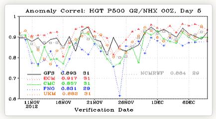
Image credit above: "Comparison between the
U.S. (GFS, black), European Center (red lines), and other modeling
systems over the northern hemisphere. The closer to one the better.
The ECMWF model (red) beats the U.S. model (black) for nearly all
days. The difference is even larger in the southern hemisphere."
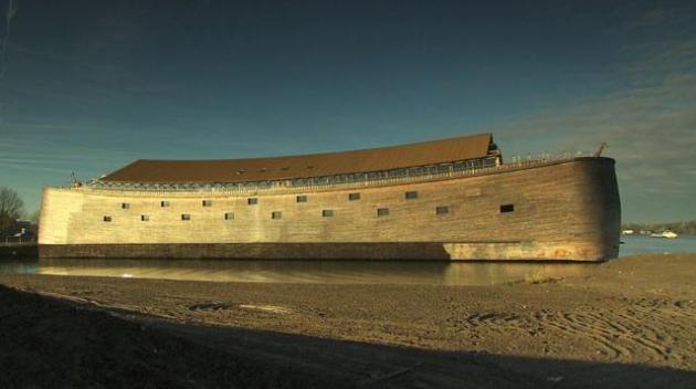
Evidence Noah's Biblical Flood Happened, Says Robert Ballard. Here's a clip from a fascinating article at
ABC News: "...
The
questions is, was there a mother of all floods," Ballard said.
According to a controversial theory proposed by two Columbia University
scientists, there really was one in the Black Sea region. They believe
that the now-salty Black Sea was once an isolated freshwater lake
surrounded by farmland, until it was flooded by an enormous wall of
water from the rising Mediterranean Sea. The force of the water was two
hundred times that of Niagara Falls, sweeping away everything in its
path. Fascinated by the idea, Ballard and his team decided to
investigate. "We went in there to look for the flood," he said. "Not
just a slow moving, advancing rise of sea level, but a really big flood
that then stayed... The land that went under stayed under....."
Photo credit above: "This ark, located an
hour south of Amsterdam, is a replica of Noah's Biblical boat.
Underwater archaeologist Robert Ballard is in Turkey, looking for
evidence that the Great Flood happened." (ABC News)
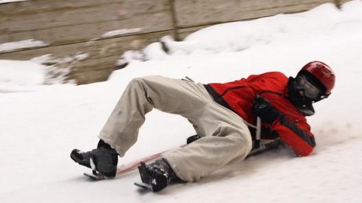
"Snowbull" Sled Takes Skiing Lying Down. I like the
lying down part. If I could put skis on my sofa I'd give that a try too.
If you're looking for a unique new snow-gadget check out this article
from
gizmag.com; here's an excerpt: "
Traditionally
the domain of small children celebrating a snow day, sledding is
slowly working its way up to a serious snow sport akin to skiing. About
a month ago, we covered the US$3,000 Snolo Stealth-X carbon fiber sled,
and now we have another high-tech sled built for serious downhillers.
The Snowbull is an Austrian-designed sled that uses high-tech
components for a sharp, fast ride...."
Top 10 Ways To Avoid Being Tracked Online. I get a lot of useful nuggets of information listening to "
Marketplace";
here's an excerpt of a story you might want to graze before plugging
your Visa number into some nameless, faceless online account:
"1. Read the agreements for all mobile phone apps
before you download them. Some of them are scary! They will track
your location using your GPS and some (like Facebook) will download ALL
OF THE CONTACTS IN YOUR PHONE. Can’t remember who you’ve handed your
data to? MyPermissions can help.
2. Read the Terms of Service Agreements for sites you give your information to. Especially
sites you give your financial information to. You maybe thinking:"I've
been on page 5 of Freedom for 8 months, HOW am I going to find the time
to read online agreements?" ToS;DR can help...."
"One Poodle Deep." How deep was the snow? About a 1-poodle storm. Who writes this stuff?
What's 111 Degrees Among Friends? Talk about extremes. Check this out, courtesy of NOAA and Chad Merrill at Earth Networks:
High Temperature for Monday, December 10, 2012
87 at Fort Pierce, FL
87 at Punta Gorda, FL
Low Temperature for Monday, December 10, 2012
-24 at Alamosa, CO
The Very Definition Of "Duh". I have no further information on this one...
 Nippy.
 Yesterday may have been one of the 2 or 3
coldest days of December - just a hunch. It sure did look and feel like
winter, with a "high" of 2 F. at Redwood Falls, after waking up to -10.
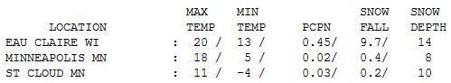
St. Cloud has 10" of snow on the ground, with 14" at Eau Claire.
Paul's Conservation Minnesota Outlook for the Twin Cities and all of Minnesota:
TODAY: Mostly cloudy, still brisk. Winds: W 10. High: 21
TUESDAY NIGHT: Patchy clouds, not quite as cold. Low: 17
WEDNESDAY: Some sun, risk of a (brief) thaw. High: 33
THURSDAY: Mix of clouds & sun. Average temps. Low: 21. High: 33
FRIDAY: Some sun, stll quiet (and dry). Low: 20. High: 31
SATURDAY: A little wet snow possible (brunt of the next storm passes east of Minnesota). Low: 19. High: near 30
SUNDAY: Clearing skies, drier day of the weekend. Low: 14. High: 27
MONDAY: Intervals of sun, seasonably cool. Low: 16. High: 29
Climate Stories...
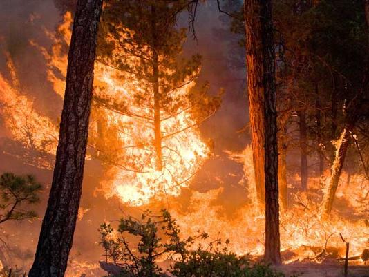
Climate Models Project Increase In U.S. Wildfire Risk.
NASA has the details; here's a clip: "
Scientists
using NASA satellite data and climate models have projected drier
conditions likely will cause increased fire activity across the United
States in coming decades. Other findings about U.S. wildfires,
including their amount of carbon emissions and how the length and
strength of fire seasons are expected to change under future climate
conditions, were also presented Tuesday at the annual meeting of the
American Geophysical Union in San Francisco..."
Photo credit above: "
The Whitewater-Baldy Complex wildfire in
Gila National Forest, New Mexico, as it burned on June 6th, 2012.
Scientists calculate that high fire years like 2012 are likely occur
two to four times per decade by mid-century, instead of once per decade
under current climate conditions."
Credit: Kari Greer/USFS Gila National Forest
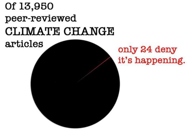
So You Think Man-Made Global Warming Is A Hoax, Eh? Here's a clip from a blog post at
The Rockford Register Star: "
The
graphic above is intended for the edification of those commenters here
at Applesauce who think there is lots of skepticism among climate
scientists about anthropogenic global warming. Take, for example, the
guy who referred just the other day to “the mountains of evidence on the
opposite side of the argument.” My response was this: “The truth is
that more than 95 percent of scientists working in the disciplines
contributing to studies of our climate accept that climate change is
almost certainly being caused by human activities. “Moreover, there are
no national or major scientific institutions anywhere in the world that
dispute the theory of anthropogenic climate change. Not one.”
Graphic credit above: "
From the Web of Science
peer-reviewed scientific articles with keyword phrases "global
warming" or "global climate change" published between 1991 and 2012." Research by JL Powell. Full article at DeSmogBlog (http://s.tt/1tBXZ)
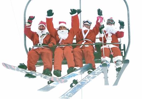
Global Warming Said To Cost Ski Resorts $1 Billion.
Theday.com
has the story; here's an excerpt: "Declines in snowfall because of
global warming are shortening the winter ski season in the United
States and harming the economy, according to a report from two
environmental groups. In poor snow seasons such as last winter, visits
drop to ski areas in states such as Colorado and New York, costing ski
resorts $1 billion in revenue over the past decade, the Natural
Resources Defense Council and Protect Our Winters said in the report
released Thursday. The winter sports industry contributes more than $12
billion a year to the U.S. economy, the study said. "Climate change
spells trouble for all businesses dependent on winter weather, from
snowmobiling, snowboarding, and ice fishing to snowshoeing and skiing,"
the groups said in the report..."
Photo credit above: Robert F. Bukaty AP Photo. "
Four
Santas ride a chairlift last Sunday at the Sunday River Ski Resort in
Newry, Maine. More than 250 skiers and snowboarders participated in the
annual Santa Sunday event to raise money to benefit the Bethel Rotary
Club's Christmas for Children program. A number of ski areas are open
now in New England, but environmental groups warn that more ski areas
throughout the Northeast and the rest of the country will have to make
their own snow and face shortened seasons because of rising global
temperatures."
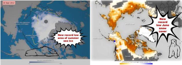
Yikes! Government Details 6 Most Terrifying Arctic Trends. The story (and graphics) from
Mother Jones; here's an excerpt: "
The National Oceanic and Atmospheric Administration (NOAA) published its seventh-annual Arctic Report Card this
week, and though they didn't hand out a grade as they have in the
past, it might as well be marked "G" for grim. Here are six of the
biggest problems up north..."
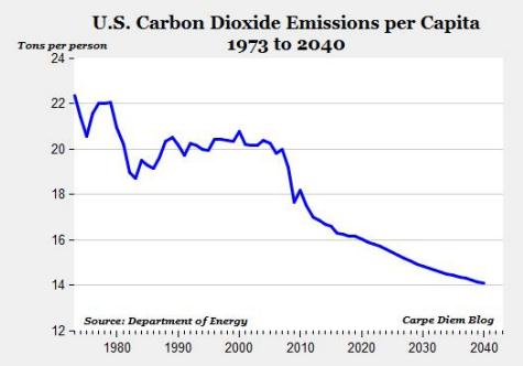
Natural Gas' Role In Combating Climate Change. Here's an excerpt of a post from David Frum at
The Daily Beast: "
The
chart above shows the Department of Energy’s estimates of CO2
emissions per capita from 1973 to 2040. Total energy-related carbon
emissions are expected to fall to a 20-year low this year, and on a
per-capita basis will be the lowest since at least 1973 when the
Department of Energy’s data begins. From the current level of 17 tons
per capita, we can expect CO2 emissions per capita to fall to 14 tons
per capita in 2040, a 25.2% decrease..."


No comments:
Post a Comment