20 F. high in the Twin Cities Tuesday.
28 F. average high on December 11.
39 F. high on December 11, 2011.
Trace of snow flurries Tuesday.
11.5" of snow so far in December.
12.3" snow so far this winter season.
8" snow on the ground (down from 10" early Monday,
due to compaction, not melting). No, there was precious little melting
yesterday. There will be some melting later today.
Temperature Matters
So how was your commute yesterday? Amazing how
nasty the roads are, more than 48 hours after The Big Dump. We're all
fixated on how many inches will fall, when we should be more focused on
the air temperature.
Wet snow falling at 25-30F is radically
different than powdery snow, with an air temperature of 10-15F. MnDOT's
de-icing chemicals work quickly and efficiently - unless - temperatures
drop below 15 F. or so. And repeated traffic on cold, freshly-fallen
snow can compress all that fresh fluff into a concrete-like sheet of
glare ice. Accumulation is important, but air temperature (at the
tail-end of a storm) is a better tip-off of how bad travel conditions
will be. Cold snows are much more problematic.
With that long, wheezy preamble - let me
reassure you that the drive will get easier today, with highs near 32F.
Yes, the ice may finally budge, even melt on dark, asphalt pavement.
ECMWF model guidance is hinting at a few inches
of (wet) snow Saturday into Sunday morning. A plowable amount is
possible, but with temperatures closer to freezing I expect less havoc
on the highways.
We may top 32 F late next week - before cooling down to the 20s for a very white Christmas.
* Photo above from Sunday's snow blitz in Minneapolis:
Brennan Jontz Photography.
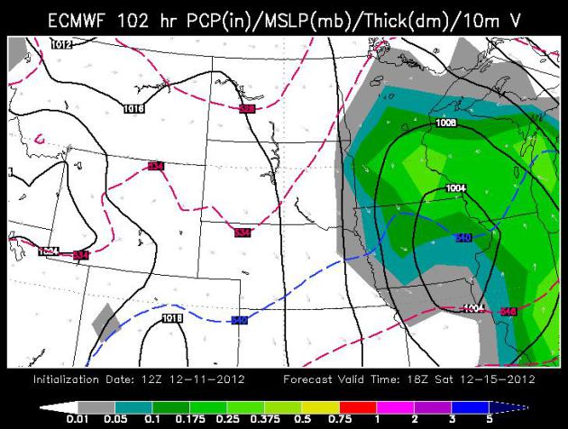
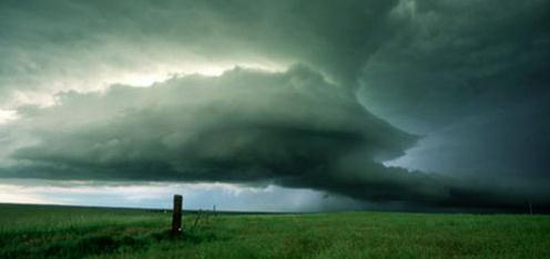
Saturday Snow? Another southern storm will make a
pass at Minnesota on Saturday. Although I don't expect anything as
severe as last Sunday, accumulating (plowable) snowfall amounts are
quite possible. The big difference? High temperatures Saturday should be
close to freezing, meaning a wet, slushy snow - and a better chance
that MnDOT de-icing equipment will be able to keep most roads ice-free
this time. In theory. ECMWF map above valid 18z Saturday, courtesy of
WSI.
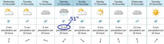
How Much? It's still early to be throwing around
inch-accumulation amounts for Saturday, but the ECMWF model is printing
out .51" liquid on Saturday, which could translate into a period of
moderate to heavy wet snow, a few inches of slush. Sunday looks drier
with some sun and highs in the low 20s.
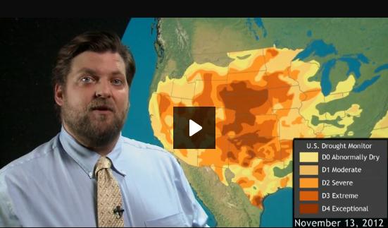
Water Waning Into Winter. Here's an update on the nagging drought from
NOAA's ClimateWatch: "...
Farmers
are feeling the pinch from all of this lack of water. We’ve already
seen damage to corn and soybeans. Now we’re beginning to see a
diminished winter wheat crop. Wheat is a staple grain, but in the winter
it often doubles as cattle forage. So it’s not just measured in loaves
of bread, but also in pounds of cow! As of November 27, the US
Department of Agriculture estimated that 65% of the winter wheat grown
in the United States was being affected by the drought. Nearly a
quarter of the winter wheat crop is categorized either in poor or very
poor condition. Across the Plains, winter wheat yields are below
average, especially in Nebraska and South Dakota, the epicenter of
drought conditions. The drought has also caused a serious water shortage
in two of the nation’s great rivers: the Missouri and the Mississippi.
Reservoir managers along the Missouri are holding water back to ensure
local supply. But less water from the Missouri means less water in the
Mississippi. If Mississippi water levels drop further, barge traffic
will be shut down. This would slow the delivery of commodities,
including fuel, and drive up prices for consumers..."
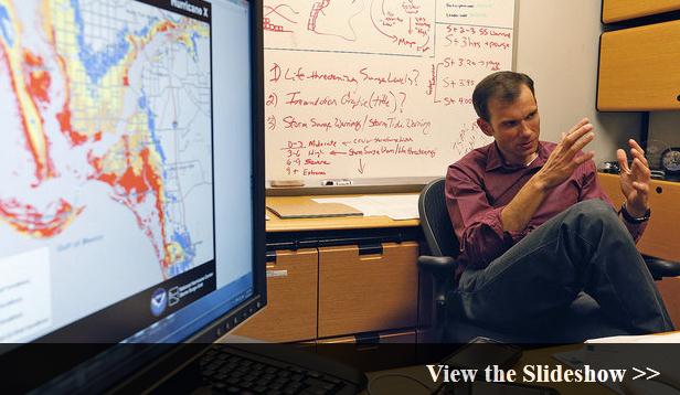
National Hurricane Center To Adopt New Storm Surge Map, Warning System Over The Next Three Years. New Orlean's
nola.com has a very interesting story - here's a clip: "
During the next three years, the National Hurricane Center
will roll out two new ways of warning the public of the risk of
hurricane storm surges. Forecasters hope the new warnings will
revolutionize the public's understanding and response to storm surge
flooding, while also quieting the growing chorus of coastal residents
who are concerned that traditional hurricane strength warnings don't go
far enough to protect them. National Hurricane Center Director Rick Knabb and Storm Surge Team Lead Jamie Rhome explained
the plans to upgrade storm surge warnings and public information
during a Wednesday meeting at the center that they requested in
response to NOLA.com | The Times-Picayune editorials urging the speedy adoption of new surge warnings..."
Photo credit above: "
(Gallery by Ted Jackson, NOLA.com | The Times-Picayune)"
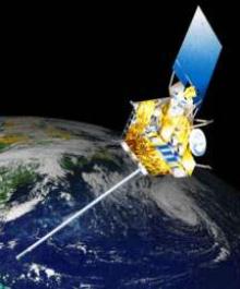
Bloomberg News: Keep Satellites Aloft To Track Bad Weather Below. Here's an excerpt of an Op-Ed from Bloomberg and
SunHerald.com: "...
Instead,
in a few years, weather predictions in the U.S. are in danger of
becoming less accurate. Why? Because the federal government is
unprepared, at least temporarily, to operate a full complement of
satellites. The gap could begin in October 2016, when a satellite put
in orbit a year ago reaches the end of its expected five-year life. A
replacement won't be ready to launch until at least March 2017, and
then it will take another year for its instruments to be checked out
and ready to operate. That would leave a 17-month gap, during which
three-to-five-day weather forecasts will be fuzzier..." Image above: NOAA
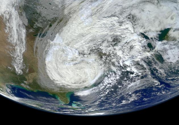
State Report Warned Of Storms As Big As Sandy.
Meteorologically, Sandy was a 2x4 across the head, at least for coastal
residents living in the Northeast. But scientists and city planners have
been warning of such a storm for many decades now. AP and
WABC-TV in New York has more: "
More
than three decades before Superstorm Sandy, a state law and a series
of legislative reports began warning New York politicians to prepare
for a storm of historic proportions, spelling out scenarios eerily
similar to what actually happened: a towering storm surge; overwhelming
flooding; swamped subway lines; widespread power outages. The Rockaway
peninsula was deemed among the "most at risk." But most of the warnings
and a requirement in a 1978 law to create a regularly updated plan for
the restoration of "vital services" after a storm went mostly
unheeded, either because of tight budgets or the lack of political will
to prepare for a hypothetical storm that may never hit..." Image above: NOAA.
Read more here: http://www.sunherald.com/2012/12/07/4346105/bloomberg-news-keep-satellites.html#storylink=cpy
An American Life, Made Better Through Big Data. Here's a clip of a fascinating article from
The Atlantic: "
Imagine
being told the storm of the century was going to hit in three
days--anywhere between New York City and Richmond, Virginia. That may
have been the scenario when superstorm Sandy turned toward the East
Coast last month. Thankfully, five years ago the National Hurricane
Center (NHC) began utilizing the Hurricane Weather Research and Forecasting model
that analyzes big data collected from satellites and airborne
observations, producing high-resolution computer-modeled forecasts every
six hours. As a result, the NHC was able to predict the storm's
landfall five days out within 30 miles of direct impact in New Jersey.
(Twenty years ago, even 72-hour forecasts were only accurate up to about
350 miles of landfall.) Big data was more than just a buzz word during
Hurricane Sandy; it saved lives. This is one clear example of the
growing role of big data in the public sector..."
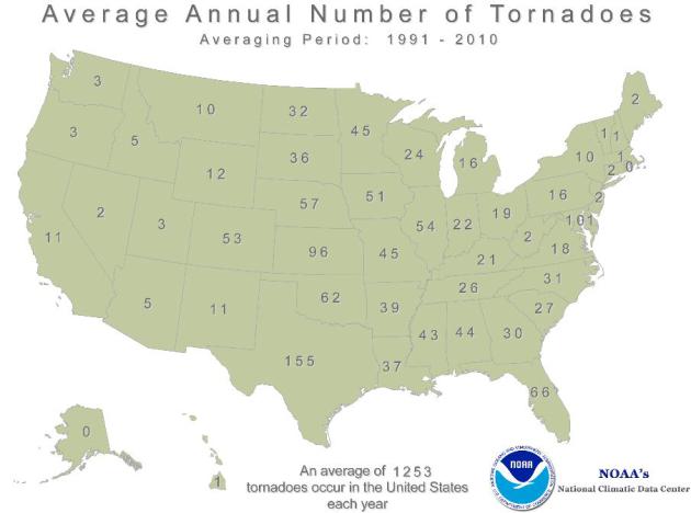
Minnesota: Twice As Many Tornadoes As Wisconsin? When did this happen? 20 year averages from
NOAA NCDC
show an average of 45 tornadoes/year in Minnesota vs. 24/year in
Wisconsin. No, we don't live in Tornado Alley, but we do live in Tornado
Cul desac. Better to hang out in Rhode Island, which has an average of
(0) tornadoes/year.
What Is The Weather Coalition? This caught my eye: "
The aim of the Weather Coalition
is to bring together industry, state and local governments, and
academia in an organized effort to urge Congress and the Executive
Branch to fund national initiatives to expand research collaborations
between these groups and federal agencies in the area of mesoscale
observations and predictions. This effort will improve the country’s
weather prediction and warning capabilities and provide assessments of
the nation’s socioeconomic vulnerability to weather. The results will
be enhanced competitiveness for U.S. industry, improved support for
national defense, and increased protection of life and property..."
Absence Of A Farm Bill Threatens Agriculture's Resilience To Extreme Weather.
Agri-Pulse has the story; here's an excerpt: "...
Congress'
inability to pass a farm bill this year, however, puts the future at
risk. Crop insurance and risk management options moving into next year -
a recovery year for food and feed stocks - are uncertain at best.
Research programs for more resilient crops are left unfunded and
incomplete. And conservation programs that implement scientifically
based best practices for managing stressed cropland and water resources
are unavailable to farmers and ranchers. Without the farm bill, program
enrollment has been halted. Necessary resources are inaccessible. with
the extreme, unpredictable weather we have been experiencing, we can't
afford not to have a farm bill. Much scientific evidence suggests that
unstable weather may become the norm...."
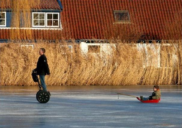
1% Sledding. Way to work up a sweat on the ice!
Reminds me of when I was 13, using my mini-bike to deliver newspapers.
Everyone is looking for an easier way to get it done. Then again, using a
Segway on what looks like fairly thin ice is one effective way to get
Nearer My God To Thee. Be careful out there. Image: Reddit and
Imgur.com.
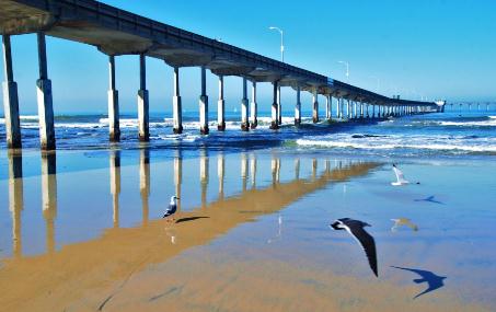
Best Weather In The USA? If you're a snow lover the
best weather is right here, in this zip code (cherish the moment). But
if you like sun, warmth and gentle breezes might I suggest San Diego,
which does have the distinction of having America's best overall
climate. Photographer Jim Grant agrees.
The Shill Becomes A Journalist. I now have even more respect for Bob Costas. Check out this article (and video) from
slate.com; here's an excerpt: "...
Sunday afternoon, in a 90-second editorial during the halftime of the Sunday night NFL game on NBC, Costas quoted from a FoxSports.com column by Jason Whitlock:
“Handguns do not enhance our safety. They exacerbate our flaws, tempt
us to escalate arguments, and bait us into embracing confrontation
rather than avoiding it.” Costas then paraphrased from earlier in
Whitlock’s column: “If Jovan Belcher didn’t possess a gun, he and
Kasandra Perkins would both be alive today...."
Twitter - Instagram Photo War Reveals New Business Realities Of Social Networks.
Poynter.org
takes a look at the new reality with social media. Consumer-first? No,
now it's monetization-first, making investors happy. Here's an
excerpt: "
The photo-sharing turf war is escalating, with Twitter copying Instagram-like features and Instagram (owned by Facebook) no longer making its photos viewable
within tweets. No matter which company wins, users will lose. It seems
time to just accept that Facebook and
Twitter’s forget-about-money-and-put-users-first startup phase is
over. Both companies are pivoting hard toward monetization and
market-share protection as their primary goals...The networks have
shifted focus from creating value to capturing value. And to capture
value, they each feel the need to lock users into their own platforms
and reduce integration, thus limiting competition..."
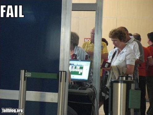
TSA Fail. No idea what airport this is - seriously doubt it's MSP. Thanks to failblog.org for passing this one along.
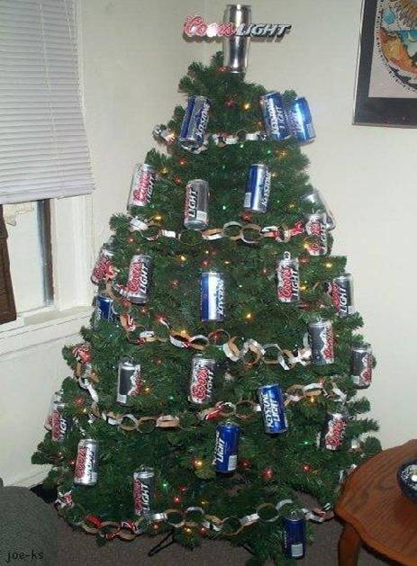
Redneck Christmas. Decorations? I don't need no
stinking decorations! Let me just finish some cans out of the recycling
bin - that will due. This is like a bad commercial for Coors Light.
Weather History on December 11, courtesy of the Twin Cities
National Weather Service:
2004: A strong cold front pushed
through Minnesota during the early morning hours. By dawn, winds
turned to the northwest and increased to 25 to 40 MPH with gusts as
high as 70 MPH. The windiest part of the day was from mid morning
through mid afternoon when many locations suffered sustained winds in
the 30 to 45 MPH range. The highest wind gusts recorded in southern
Minnesota during this time included 71 MPH in Welch and 62 MPH near
Albert Lea, St. James, Winthrop and Owatonna. Other notable wind gusts
included 59 MPH at New Ulm, 58 MPH in Mankato, 55 MPH in St. Cloud and
Morris, 54 MPH at Redwood Falls, and 52 MPH at the Minneapolis/St. Paul
International Airport. Scattered trees were downed and a few buildings
received minor roof damage across the region.
1939: December gale at north shore; winds clocked at 48 mph at Duluth.
Paul's Conservation Minnesota Outlook for the Twin Cities and all of Minnesota:
TODAY: Milder. Patchy clouds. Commutes should get a little easier. Winds: S 10-15. High: 32
WEDNESDAY NIGHT: More clouds. Low: 23
THURSDAY: Mostly gray, roads turn to slush. High: 33
FRIDAY: Dry sky. Peeks of sun. Low: 20. High: 31
SATURDAY: Period of wet snow expected - potential for a couple inches of slush. Low: 23. High: 32
SUNDAY: Partial clearing, better travel conditions. Turning colder. Low: 18. High: 23
MONDAY: Colder with blue sky. Low: 10. High: 19
TUESDAY: Mix of clouds and sun, still chilly. Low: 8. High: 21
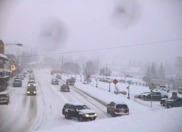
* photo above courtesy of Randy Peterson, who snapped this photo up in Champlin.
Climate Stories...
Climate Change Consensus Is Virtually Unanimous. Are
you researching peer-reviewed science, or just forwarding blog posts
from deniers (often funded by fossil fuel companies?) Here's an excerpt
of a story from
Huffington Post: "
A recent analysis
of papers appearing in peer-reviewed science journals shows published
scientists to be virtually unanimous in their agreement that
human-produced carbon dioxide emissions are a significant cause of
global warming. You are free to disagree with my characterization of the
consensus as "virtually unanimous," if you feel 99.83 percent doesn't
qualify. There are, after all, almost two-tenths of one percent who
dissent from the majority assessment. Oberlin College geologist Dr. James L. Powell
reviewed 13,950 papers published between January, 1991 and early
November, 2012, and found that a mere 24 of them dissented. That's .17
percent. 1 out of every 581. Powell further makes the point that those
24 were, on average, the least cited of the papers, saying, "Of one
thing we can be certain: had any of these articles presented the magic
bullet that falsifies human-caused global warming, that article would be
on its way to becoming one of the most-cited in the history of
science..."
Wind And Solar Power Paired With Storage Could Power Grid 99.9% Of The Time. Forget
plastics - consider investing in high capacity battery storage
technologies that can "save" power generated by wind and solar, and
release it onto the grid when needed over time.
Science Daily has the story; here's an excerpt: "
Renewable
energy could fully power a large electric grid 99.9 percent of the time
by 2030 at costs comparable to today's electrical expenses, accorduing
to new research by the University of Delaware and Delaware Technical
Community College..."


I want have to know more and more, on your blog just interesting and useful information. Keep it up! Affordable Life Insurance
ReplyDelete