38F. afternoon high in the Twin Cities Thursday (warmer than predicted, yes).
27 F. average high for December 14.
38 F. high on December 14, 2011.
6" snow on the ground in the metro area Thursday morning.
Rain/Snow mix on Saturday, potential for a slushy 1-2" late Saturday and Saturday night.
Saturday Slop-storm
How are you holding up during the joyously stressful month of December? Tree. Gifts. Cookies. Relatives. Credit cards. Aspirin.
Check.
If it's any consolation foul weather won't add to your merry agitation between now and Christmas.
Yesterday I wore a light spring coat to the
office ("mid 30s - hooray!") which may be an omen for Saturday's
precipitation event. Another big surge of southern moisture will push a
shield of mixed precipitation into the state. Models print out nearly a
half inch of liquid, but BUFKIT (a 3-D temperature analysis of the
future atmosphere draped over Minnesota) shows enough warm air for rain
changing to wet snow; maybe a few sloppy inches by Saturday afternoon.
Some of that rain may freeze on cold surfaces early Saturday; watch for
glaze ice on bridges and side streets early in the day.
Rain 6 days
before the Winter Solstice? Why not.
In spite of uncertainties spinning around the
Mayan calendar, we will have Christmas this year - another burst of
light snow arrives next Thursday, followed by a cold spell into
Christmas week.
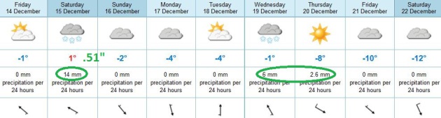
Last winter was brown; under 1" on the ground. This year I expect a healthy 3-5" of (crusty) snow for Santa's arrival.
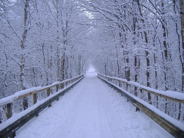
* image above courtesy of Loveland Ski Resort (and Santa, of course)
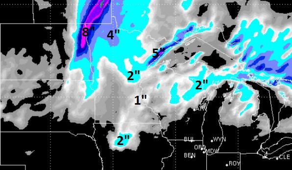
More Rain Than Snow? The latest 72 hour
WSI RPM solution shows a whopping inch of slushy snow in the metro,
closer to 2" near Mille Lacs and Sandstone, maybe 4-5" along Lake
Superior's North Shore. This will NOT be like Sunday - I expect a messy
storm with rain and freezing rain slowly changing over to wet snow late
Saturday and Saturday night, the best chance of a sloppy inch or two
north/west of MSP.
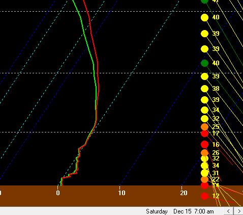
Skew T. The predicted sounding (vertical temperature
and wind profile) at 7 am Saturday shows a layer of warm air in the
lowest 4,000 feet of the atmosphere with temperatures just above 32 F,
probably warm enough for a period of rain and sleet, ending as wet snow
later in the day and Saturday night as the column of air overhead begins
to cool.
Saturday Mix - But Feeling Better About A White Christmas.
Although we may only wind up with an inch or two of slushy snow late
Saturday, the ECMWF solution (above) shows a few more inches of snow
possible late Wednesday into early Thursday of next week, followed by
colder weather as we sail into the weekend of December 21-22, highs in
the upper teens and low 20s. Notice there will be weather on Saturday,
December 22, in spite of what some people believe the Mayan calendar
portends.
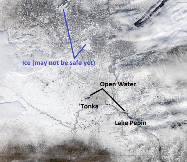
Unstable Ice. I can't stress enough to outdoor
enthusiasts of all ages that ice in and around the Twin Cities, even St.
Cloud, is still not even close to being "safe". Mille Lacs, Gull and
the Whitefish Chain is mostly ice-covered, but you should absolutely
check with local authorities before dragging your ice house out. NASA's
1,000 meter
MODIS satellite still showed open water on metro lakes yesterday, extending south to Mankato and Lake Pepin. Be careful out there.
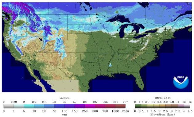
Slight Shrinkage.
NOAA
data shows snow on the ground over 27.6% of the lower 48 states,
compared with 31% of the same area a month ago, on November 13, 2012.
Many northern tier cities will see a white Christmas. The rest of the
USA? Not so much.
A Cold (Dry) Christmas 2012. Canadian long-range
(NAEFS) model guidance above shows a cooling trend into Christmas for
the Twin Cities, relatively light winds, a trend toward increasing
sunshine, with little in the way of precipitation once we get past
Saturday night.
The Weather Cliff? New Study Warns Of Sequestration Impacts To NASA, NOAA Programs. Here's an excerpt from a post at the
Second to None web site: "
A new economic impact analysis
concludes that over 20,000 NASA contractor jobs and over 2,500 NOAA
jobs related to weather satellites could be lost in 2013 if the Budget
Control Act’s sequestration mandate takes effect on January 2, 2013.
“This report demonstrates that the biggest single threat to our space
programs’ continued success are arbitrary and capricious budget cuts,”
said AIA President and CEO Marion C. Blakey. “NASA and NOAA are
responsible for cutting edge activities that expand the boundaries of
knowledge and discovery, lead to economic innovation and save lives. We
can’t afford not to invest in these sources of American scientific and
technological greatness...”
The Geminid Meteor Shower Is Underway. Interested in astronomy, or curious about what's in the nighttime sky on any given night? You can't do much better than
spaceweather.com, which has more on the Geminids: "
International observers are counting
as many as 50 meteors per hour as Earth
plunges into a stream of debris from rock comet
3200 Phaethon. Rates could double, or
more, when the shower peaks on Dec. 13th and 14th.
The best time to look is during the dark hours before
dawn on Thursday and Friday." [
sky map] [
meteor radar] [
video]
* NASA has a live stream of the Geminid Meteor Shower
here.
I have some great readers tuning in on a consistent basis - I can
assure you I don't take that for granted. It's been a rough couple of
weeks for me and my family, and I wanted to share an e-mail and poem
sent in to the Star Tribune by Lydia Holsten. I wanted to thank her for
reaching out - and dedicate this to anyone who has lost a friend or
loved one in 2012:
Dear Paul - I
have had your Nov. 29th column on my desk and am sorry it has taken me
this long to send you a note of sympathy on your Amazing Grace's
passing. Please know Ted and I are so sorry. We never have our moms
long enough, dear Paul. Our prayers are with you during this Christmas
season for a peace that passes understanding. The
lessons Grace taught you DO come through in well writen columns. Paul
Douglas is the first thing discussed over coffee in our home on
Smithtown Bay. I'm not sure if you know the Philip Levine poem "Snow",
but I love the last lines that call snow frozen tears from heaven.
Maybe the beautiful snow that fell on Sunday was a reminder from your
Mom - "There, there, Paul. All is well with me." (I'll copy the poem
below.)
Blessings, dear Paul Douglas, to you and your family.
Lydia Holsten
"Snow"
by Philip Levine
Today the snow is drifting
on Belle Isle, and the ducks
are searching for some opening
to the filthy waters of their river.
On Grand River Avenue, which is not
in Venice but in Detroit, Michigan,
the traffic has slowed to a standstill
and yet a sober man has hit a parked car
and swears to the police he was
not guilty. The bright squads of children
on ther way to school howl
at the foolishness of the world
they will try not to inherit.
Seen from inside a window,
even a filthy one like those
at Automotive Supply Company, the snow
which has been falling for hours
is more beautiful than even the spring
grass which once unfurled here
before the invention of steel and fire,
for spring grass is what the earth sang
in answer to the new sun, to
melting snow, and the dark rain
of spring nights. But snow is nothing.
It has no melody or form, it
is as though the tears of all
the lost souls rose to heaven
and were finally heard and blessed
with substance and the power of flight
and given their choice chose then
to return to earth, to lay their
great pale cheek against the burning
cheek of earth and say, There, there, child.
"To live long it is necessary to live slowly..." - Cicero
" You can't reason someone out of a position they didn't reason themselves into..." - Anonymous
Paul's Conservation Minnesota Outlook for the Twin Cities and all of Minnesota
TODAY: Dim sun. Clouds increase. Winds: E 10. High: 35
FRIDAY NIGHT: Cloudy, dry evening. Rain or freezing rain (glaze ice) possible late. Low: 29
SATURDAY: Ice possible early. Rain/snow mix, 1-2 inches of slush (best chance north/west of MSP) High: 34
SATURDAY NIGHT: An inch or so of wet snow. Low: 23
SUNDAY: Partial clearing, better driving conditions statewide. High: near 30
MONDAY: More clouds than sun - brisk. Low: 16. High: 27
TUESDAY: Intervals of sun, still dry. Low: 15. High: 28
WEDNESDAY: Clouds increase, light snow late. Low: 20. High: 31
THURSDAY: Flurries taper, slow clearing. Cold. Low: 14. High: 23
*
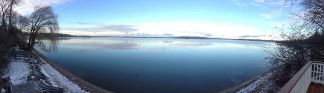
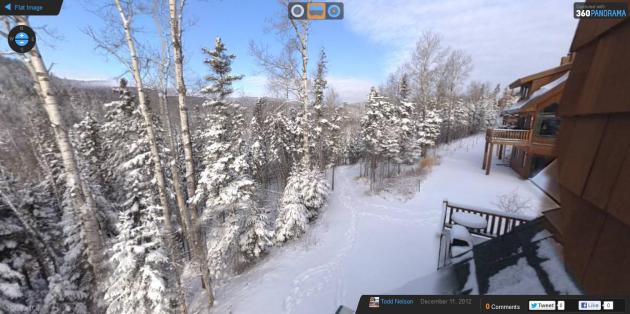
3-D panorama of Lutsen above courtesy of WeatherNation TV meteorologist Todd Nelson.
Climate Stories...
Rising Temperatures Threaten Fundamental Change For Ski Slopes. Here's a snippet of an article at
The New York Times: "...
Whether this winter turns out to be warm or cold, scientists say that climate change
means the long-term outlook for skiers everywhere is bleak. The threat
of global warming hangs over almost every resort, from Sugarloaf in
Maine to Squaw Valley in California. As temperatures rise, analysts
predict that scores of the nation’s ski centers, especially those at
lower elevations and latitudes, will eventually vanish. Under certain
warming forecasts, more than half of the 103 ski resorts in the
Northeast will not be able to maintain a 100-day season by 2039,
according to a study to be published next year by Daniel Scott, director
of the Interdisciplinary Center on Climate Change at the University of
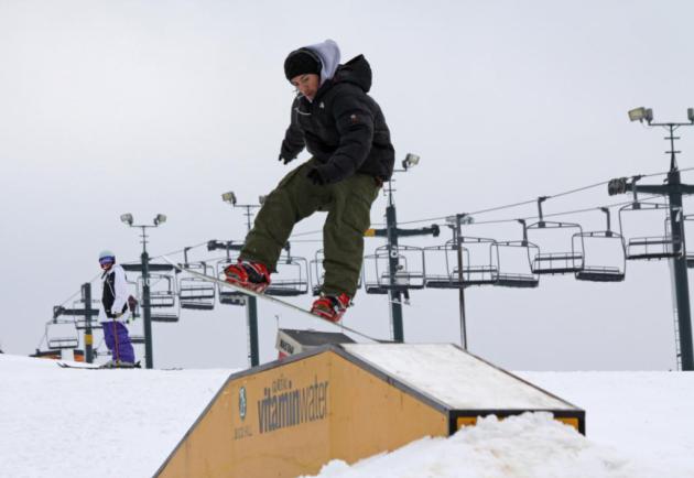
Waterloo in Ontario..." Photo courtesy of Buck Hill.
A Conservative, Small-Government Strategy For Fighting Climate Change. Here's an excerpt of a
Forbes Op-Ed from Bob Ingliss, a former Republican Congressman from South Carolina: "...
Conservatives
have the answer to energy and climate and it doesn’t grow government.
We need to leave behind the science denial of the past few years and
the knee-jerk embrace of fossil fuels. We need to rally around a
superior solution. That solution would look at the real costs and the
real benefits. As part of tax reform in this year’s fiscal fix or next
year’s bigger fiscal fix, let’s empower our energy economy with free
enterprise:
- Do a revenue-neutral tax swap that reduces taxes on income
and shifts the tax onto carbon dioxide, thereby attaching to fossil
fuels an approximation of the cost of their negative externalities.
[Note: Make sure to keep this revenue-neutral. You may have to add
revenue elsewhere in a grand bargain, but the goal of this tax swap is
the correction of a market distortion, not the raising of revenue.]
- Eliminate all subsidies for all fuels, thereby correcting yet another market distortion called government failure."
Big Oil's Pipe Dream. Greg Laden has a thought-provoking Op-Ed at
MN Progressive Project; here's an excerpt: "
Unconventional
oil exploitation matters to Minnesotans. Not only are many Minnesotans
off in some Fracking field somewhere collecting nest eggs, but
Fracking and other extraction techniques can be done here, or near
here, and may have significant influences on the environment. Also,
Minnesotans are in a special situation when it comes to the use of
fossil fuels. Because of the current configuration of supply lines and
refineries, we happen to have cheap fuel in the North Star State, but
that relies partly on the use of Canadian sources which would be shunted
to other locations with the construction of certain pipelines, and
that all has to do with efforts by the industry and government to keep
the flow of fuel fast and furious..."


No comments:
Post a Comment