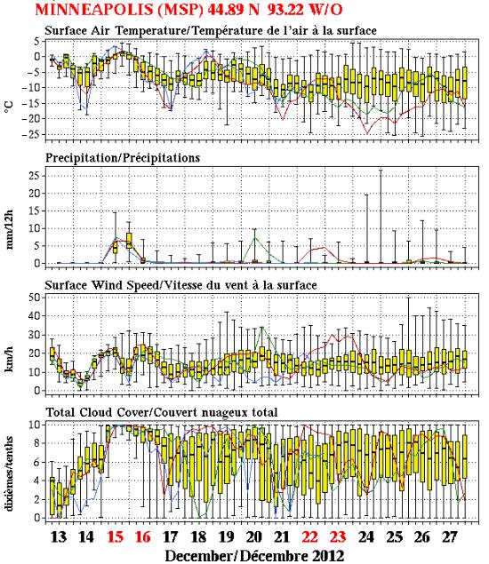
37 F. high in the Twin Cities Friday.
27 F. average high on December 14.
39 F. high on December 14, 2011.
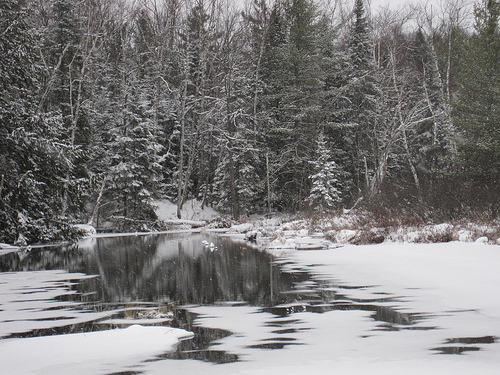
6" snow on the ground in the metro area.
+7.2 F. The first 2 weeks of December are running more than 7 F. warmer than average in the Twin Cities.
Rain Dear
My 8 year old niece told me not to sweat
Christmas this year. "It doesn't matter whether it snows or not" she
whispered. Say what? "We're OK, because Santa has RAIN DEER!" Amen.
I've heard a few wild rumors about 8 to 12
inches of snow for the metro. That's simply not going to happen. To get
(all) snow the temperature profile of the lowest mile of the atmosphere
has to be colder than 32 F. That won't be the case today; snow melting
into rain drops, possibly freezing into a little glaze ice early today
(watch the bridges).
A changeover back to wet snow is likely tonight;
a couple inches of slush may complicate the drive to church tomorrow
morning, but this will NOT be a repeat of last Sunday. Not even close.
Models show a few inches of snow next Thursday,
probably enough to assure a bright-white Christmas this year, with highs
stuck in the teens under blue sky.
The weather blog includes updates on the Geminid
meteor shower, our drought, and estimates that only 25-35 percent of
the USA will have snow for Christmas.
From State Climatologist Greg Spoden: December
is 7F warmer than average. If we finish 4.3F warmer - 2012 will be the
Twin Cities' warmest year on record. Details below.
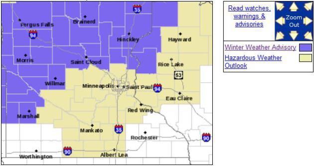
Winter Weather Advisory. The NWS has issued a Winter
Weather Advisory from Marshall, Willmar and Morris and Alexandria to
St. Cloud and Brainerd for a little ice this morning, followed by rain
ending as a couple inches of snow. Details:
...A WINTRY MIX OF PRECIPITATION FOR LATE TONIGHT AND SATURDAY...

.THE WINTER WEATHER ADVISORY HAS BEEN EXPANDED EAST ACROSS MUCH OF
CENTRAL MINNESOTA AND A SMALL PART OF WEST CENTRAL WISCONSIN. THE
ADVISORY IS NOW IN EFFECT...NORTH AND WEST OF A LINE FROM GRANITE
FALLS...TO ST CLOUD AND BALSAM LAKE...FROM 3 AM TONIGHT TO 3 PM
SATURDAY. THIS IS FOR THE POTENTIAL COMBINATION OF FREEZING RAIN
FOLLOWED BY ACCUMULATING SNOW.

PRECIPITATION IS EXPECTED TO QUICKLY SPREAD INTO THE REGION LATE
TONIGHT AND MOVE OUT SATURDAY EVENING. FOR THE FIRST FEW HOURS
AFTER PRECIPITATION STARTS...IT IS EXPECTED TO COME DOWN AS
LIQUID. SURFACE TEMPERATURES WILL BE NEAR FREEZING AS THIS OCCURS...
AND WHERE TEMPERATURES CAN REMAIN BELOW FREEZING...THE PRECIPITATION
WILL BE IN THE FORM OF FREEZING RAIN. AFTER SUNRISE SATURDAY...
THE PRECIPITATION WILL TRANSITION OVER TO RAIN AND SNOW...WITH 1
TO 3 INCHES OF SNOW POSSIBLE DURING THE DAY.

BE PREPARED FOR SLIPPERY ROADS AND LIMITED VISIBILITIES...AND USE
CAUTION WHILE DRIVING.

Somewhere Between Nuisance and Plowable The latest
72 hour WSI RPM model suggests an inch or two of slush tonight into
Sunday morning for the Twin Cities metro, maybe 2"+ over the western
suburbs, as much as 4" near Redwood Falls and Marshall.
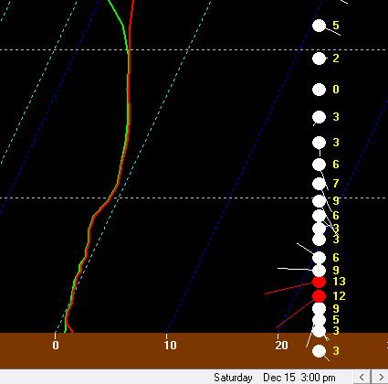
Skew T. The predicted sounding (vertical temperature
and wind profile) at 3 pm shows temperatures overhead falling below 32
F aloft, with rain changing to sleet and then wet snow by late
afternoon or evening. Precipitation should fall as mainly rain during
the morning and midday hours. Roads may become slushy and slick tonight.
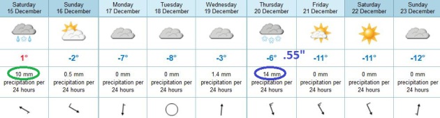 ECMWF Trend: Colder and Snowier
.
The latest European model shows mostly rain today for the Twin Cities,
ending as an inch or two of wet snow tonight; dry weather from midday
Sunday into Wednesday. A half inch of liquid is predicted for next
Thursday, with temperatures cold enough for (all snow). The result may
be several inches of accumulation, perhaps 4"+, before considerably
colder weather returns late next week, highs in the teens to near 20.
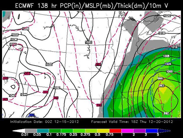
Close Encounter.
The 00z ECMWF model shows the bulk of any snow next Thursday sliding
off south/east of MSP, maybe brushing far southeastern Minnesota. Too
early to say right now, but this may be a big snowstorm from Des Moines
to Madison, Milwaukee and Chicago. WSI model guidance above valid 18z
next Thursday.
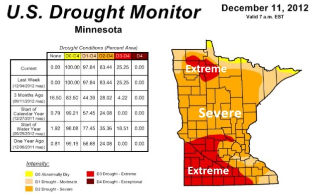
Drought Details. Dr. Mark Seeley has more details about Minnesota's ongoing drought in this week's edition of
Minnesota WeatherTalk; here's an excerpt: "
The weekly Drought Update from Brad Rippey with the USDA World Agricultural Outlook Board includes the following comments:
-The portion of the contiguous U.S. in the worst category – D4, or
exceptional drought – remained virtually unchanged at 6% (rounded) for
the eighteenth consecutive week (August 14 – December 11).
-Hay in drought fell slightly to 64%, but has been at or above 60% for 23 consecutive weeks – since July 10.
-Cattle in drought was unchanged at 73%, and has been greater than
two-thirds of the domestic inventory for 23 consecutive weeks (July 10 –
December 11).
-Winter wheat in drought was down slightly to 63%, although the hard
red winter wheat belt – especially from South Dakota to Texas – remains
deeply entrenched in drought."
* the latest Minnesota Drought Monitor from NOAA is
here.
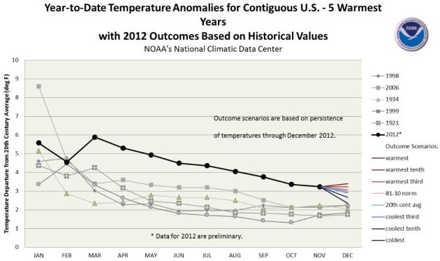
2012: Probably The Warmest Year In Recorded U.S. History. Here are a few bullet points from
NOAA NCDC:
- The January-November period was the warmest first 11 months of
any year on record for the contiguous United States. The national
temperature of 57.1°F was 3.3°F above the 20th century average, and
1.0°F above the previous record warm January-November of 1934. During
the 11-month period, 18 states were record warm and an additional 24
states were top ten warm.
- It appears virtually certain that 2012 will surpass the current
record (1998, 54.3°F) as the warmest year for the nation. December 2012
temperatures would need to be more than 1.0°F colder than the coldest
December (1983) for 2012 to not break the record.
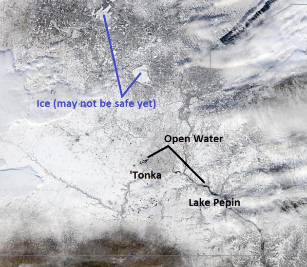
Unstable Ice. I can't stress enough to outdoor
enthusiasts of all ages that ice in and around the Twin Cities, even St.
Cloud, is still not even close to being "safe". Mille Lacs, Gull and
the Whitefish Chain is mostly ice-covered, but you should absolutely
check with local authorities before dragging your ice house out. NASA's
1,000 meter
MODIS satellite still showed open water on metro lakes yesterday, extending south to Mankato and Lake Pepin. Be careful out there.
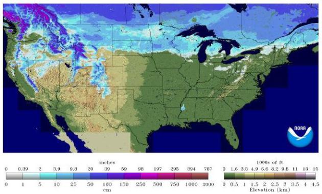
Slight Shrinkage.
NOAA
data shows snow on the ground over 27.6% of the lower 48 states,
compared with 31% of the same area a month ago, on November 13, 2012.
Many northern tier cities will see a white Christmas. The rest of the
USA? Not so much.
A Cold (Dry) Christmas 2012. Canadian long-range
(NAEFS) model guidance above shows a cooling trend into Christmas for
the Twin Cities, relatively light winds, a trend toward increasing
sunshine, with little in the way of precipitation once we get past
Saturday night.
The Weather Cliff? New Study Warns Of Sequestration Impacts To NASA, NOAA Programs. Here's an excerpt from a post at the
Second to None web site: "
A new economic impact analysis
concludes that over 20,000 NASA contractor jobs and over 2,500 NOAA
jobs related to weather satellites could be lost in 2013 if the Budget
Control Act’s sequestration mandate takes effect on January 2, 2013.
“This report demonstrates that the biggest single threat to our space
programs’ continued success are arbitrary and capricious budget cuts,”
said AIA President and CEO Marion C. Blakey. “NASA and NOAA are
responsible for cutting edge activities that expand the boundaries of
knowledge and discovery, lead to economic innovation and save lives. We
can’t afford not to invest in these sources of American scientific
and technological greatness...”
Editorial: Why No Hurricane Warnings For Sandy? Here's a portion of an Op-Ed from
USA Today: "
When Sandy clobbered the Northeast on Oct. 29, it carried torrential rains, record flooding — and hurricane-force winds.
Gusts reached 90 mph in New York and New Jersey, 86 mph in Rhode
Island, 85 mph in Connecticut, 83 mph in Massachusetts and 81 mph in
Pennsylvania. Despite these clear-cut Category 1 conditions, however, no
hurricane watches or warnings were posted in any of those states.
OPPOSING VIEW: Our warnings were clear and effective
Why not? In the six weeks since Sandy struck, a lot of people in
the forecasting community have been asking that question. The emerging
answers suggest that, faced with a pair of unusual challenges from
Sandy, government forecasters rose to one test and bungled the other..."
Hurricane Sandy Relief Aid Already In Jeopardy In Congress. Nice of our elected representatives to turn Sandy's recovery into another political freak show; details from
MSNBC: "
President Obama has submitted a $60.4 billion relief package for areas affected by Hurricane Sandy, which is actually below the total aid request from the governors of New York, New Jersey, and Connecticut, but as promised, Congress is not in a generous mood.
House lawmakers don't intend to introduce an emergency funding
bill anywhere near as large as the $60 billion the Obama administration
is seeking to help rebuild the Northeast after superstorm Sandy,
saying the administration hasn't provided sufficient details to justify
spending that amount, two senior GOP aides said Wednesday.
If the Republican-controlled House doesn't take up the measure
this year, it would push debate on a large rebuilding bill into next
year -- something New York and New Jersey officials have said they want
to avoid..."
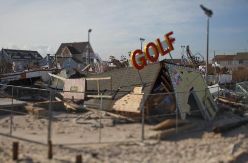
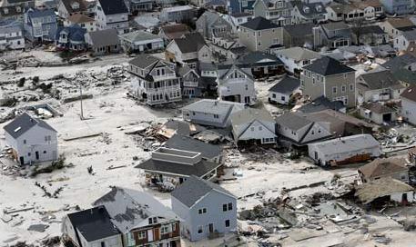
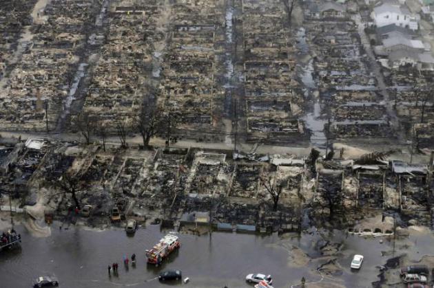
Photo credit: " A miniature golf course destroyed by Hurricane
Sandy at Jenkinson's Boardwalk in Point Pleasant Beach, N.J., Nov. 28,
2012. A month after Hurricane Sandy wreaked havoc along the Jersey
Shore, the area is slowly starting to recover. (Fred R. Conrad/The New
York Times)
The Geminid Meteor Shower Is Underway. Interested in astronomy, or curious about what's in the nighttime sky on any given night? You can't do much better than
spaceweather.com, which has more on the Geminids: "
International observers are counting
as many as 50 meteors per hour as Earth
plunges into a stream of debris from rock comet
3200 Phaethon. Rates could double, or
more, when the shower peaks on Dec. 13th and 14th.
The best time to look is during the dark hours before
dawn on Thursday and Friday." [
sky map] [
meteor radar] [
video]
* NASA has a live stream of the Geminid Meteor Shower
here.
TODAY: Icy patches early. Mostly rain. Winds: E/SE 10-15. High: 35
SATURDAY NIGHT: Changeover to wet snow, 1-2" possible. Low: 31
SUNDAY: Light snow tapers to
flurries. Some sun possible by afternoon. Slick spots as temperatures
fall below 32 F. High: 31 (falling into the 20s by midday and afternoon)
MONDAY: More clouds than sun. Dry and chilly. Low: 19. High: 25
TUESDAY: Clouds increase, PM flurries possible. Low: 13. High: 29
WEDNESDAY: Fading sun, a bit milder. Low: 18. High: 34
THURSDAY: Cloudy with a chance of snow (latest models keep heaviest amounts south/east of Minnesota). Low: 23. High: 28
FRIDAY: Sun returns, better travel. Colder, with wind chills dipping below zero. Low: 13. High: 18
Climate Stories...
Extreme Weather More Persuasive On Climate Change Than Scientists.
Some people may not believe peer-reviewed science, but it appears they
do believe their own eyes (and personal experiences). Here's an excerpt
from
The Guardian: "
As
one of the Marx brothers famously said: who do you believe, me or your
own eyes? Climate sceptics, it turns out, are much more likely to
believe direct evidence of a changing climate in the form of extreme
weather events than they do scientists, when it comes to global
warming. A poll released on Friday by the Associated Press-GfK found rising concern about climate change
among Americans in general, with 80% citing it as a serious problem
for the US, up from 73% in 2009. Belief and worry about climate change
were rising faster still among people who do tend not to trust
scientists on the environment..."
Photo credit: "
Homes left in the wake of superstorm Sandy in Seaside Heights, New Jersey." Photograph: Mike Groll/AP
AP-Gfk Poll: Belief In Climate Change Rises With Thermometers, Even Among US Science Doubters. Here's an excerpt from an
Associated Press Gfk poll: "
Nearly
4 out of 5 Americans now think temperatures are rising and that global
warming will be a serious problem for the United States if nothing is
done about it, a new Associated Press-GfK poll finds. Belief and worry
about climate change are inching up among Americans in general, but
concern is growing faster among people who don’t often trust scientists
on the environment. In follow-up interviews, some of those doubters
said they believe their own eyes as they’ve watched thermometers rise,
New York City subway tunnels flood, polar ice melt and Midwestern farm
fields dry up...."
IPCC Draft Report Leaked: Shows Global Warming Is NOT Due To The Sun.
More on the leaking of the upcoming IPCC report, how it's being spun by
the Climate Denial Machine, and what it really says, at
Skeptical Science; here's an excerpt: "
Alec Rawls,
an occasional guest poster on the climate contrarian blog
WattsUpWithThat who signed up to review the upcoming Intergovernmental
Panel on Climate Change (IPCC) Fifth Assessment Report (as anyone can), has "leaked" a draft version of the report and declared that it "contains game-changing admission of enhanced solar forcing." This assertion was then repeated by James Delingpole at The Telegraph
(with some added colorful language), and probably on many other climate
contrarian blogs. If the IPCC were to report that the sun is a
significant player in the current rapid global warming, that would
indeed be major news, because the body of peer-reviewed scientific literature and data clearly show that the sun has made little if any contribution to the observed global warming over the past 50+ years..."
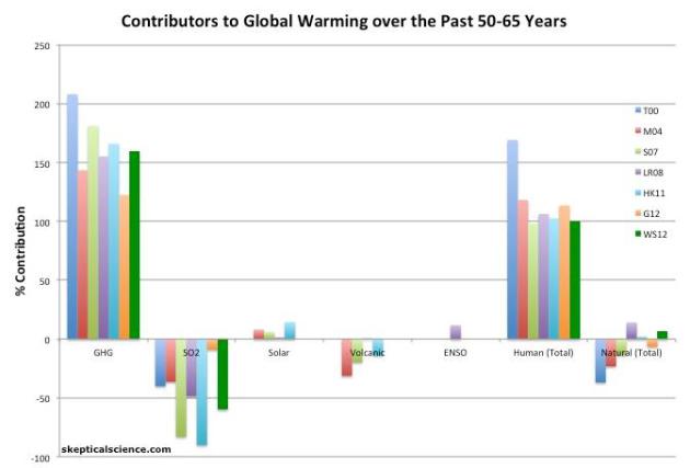
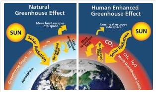
Image credit above: "
Percent
contributions of greenhouse gases (GHGs), sulfur dioxide (SO2), the
sun, volcanoes, and El Niño Southern Oscillation (ENSO) to the observed
global surface warming over the past 50-65 years according to Tett et al. 2000 (T00, dark blue), Meehl et al. 2004 (M04, red), Stone et al. 2007 (S07, green), Lean and Rind 2008 (LR08, purple), Huber and Knutti 2011 (HK11, light blue), Gillett et al. 2012 (G12, orange), and Wigley and Santer 2012 (WS12, dark green)."
Early Draft Of International Climate Science Report Posted Online. More on the apparent leak of a (preliminary) IPCC report, due out next September, from
The Union of Concerned Scientists; here's an excerpt: "
Yesterday,
a blogger who had signed up to review a forthcoming Intergovernmental
Panel on Climate Change (IPCC) report on climate science posted unauthorized drafts online.
Below is a statement by Peter Frumhoff, Science and Policy Director at
the Union of Concerned Scientists and a lead author for the IPCC’s
2007 report: “The report is a draft and will change. Overall, scientific
groups like the IPCC recognize that climate change is happening faster
and with greater consequences than previously anticipated. Whether
it’s the National Academy of Sciences or the United States Global
Change Research Program, there is, and will remain a strong scientific
basis to inform and motivate policymakers to reduce the serious risks
that climate change poses for our nation and the world..."
* Global Warming is not due to the sun, according to leaked IPCC report. The U.K. Guardian has
details.
Insurance Industry Paying Increasing Attention To Climate Change. The data is the data - the trends are the trends, as described in this excerpt from
Science Daily: "...
Weather
and climate-related insurance lossses today average $50 billion a year.
These losses have more than doubled each decade since the 1980s,
adjusted for inflation," says the study's author Evan Mills, a scientist
in Lawrence Berkeley National Laboratory (Berkeley Lab's Environmental
Energy Technologies division). "Insurers have become quite adept at
quantifying and managing the risks of climate change, and using their
market presence to drive broader societal efforts at mitigation and
adaptation...."
Libertarians, Engineers, and Climate Disruption Denial: Part 1. The psychology of denial is examined in this post at
Scholars and Rogues; here's an excerpt: "...
Ever
since I encountered my first example of a climate disruption denier
I’ve wondered what kind of person could deny the reality that is
industrial climate disruption. Over the years of writing on climate,
however, it became clear that there were two groups of people who made
up the majority of the serious deniers – libertarians and engineers of
various stripes. As an electrical engineer myself, however, I didn’t
understand how individuals trained in mathematics, science, and logic
could fail to see glaring scientific, mathematical, physical, or logical
flaws in their own arguments. Eventually, though, something clicked:
most of the engineers I work with today and have worked with since
earning my MSEE are either libertarians themselves or have some
libertarian leanings. This is the first part of a series of posts
exploring the personality traits and moral values of libertarians,
engineers, and the relationship of those traits and values to the
denial of industrial climate disruption..."
Image credit above: National Park Service, Will Elder
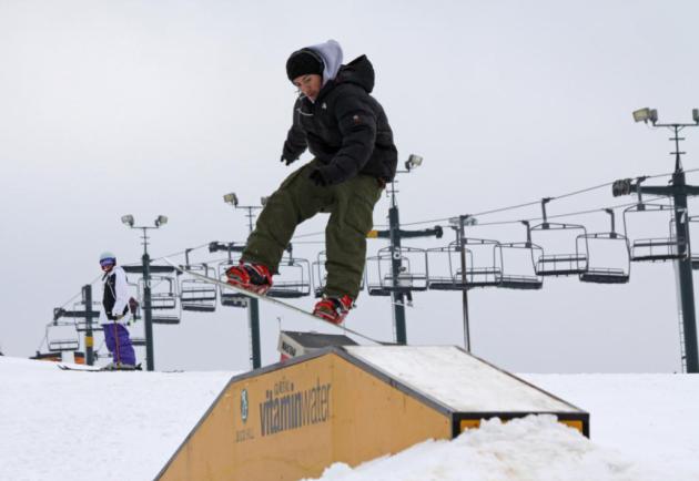
Rising Temperatures Threaten Fundamental Change For Ski Slopes. Here's a snippet of an article at
The New York Times: "...
Whether this winter turns out to be warm or cold, scientists say that climate change
means the long-term outlook for skiers everywhere is bleak. The
threat of global warming hangs over almost every resort, from
Sugarloaf in Maine to Squaw Valley in California. As temperatures
rise, analysts predict that scores of the nation’s ski centers,
especially those at lower elevations and latitudes, will eventually
vanish. Under certain warming forecasts, more than half of the 103 ski
resorts in the Northeast will not be able to maintain a 100-day season
by 2039, according to a study to be published next year by Daniel
Scott, director of the Interdisciplinary Center on Climate Change at
the University of Waterloo in Ontario..." Photo courtesy of Buck Hill.
A Conservative, Small-Government Strategy For Fighting Climate Change. Here's an excerpt of a
Forbes Op-Ed from Bob Ingliss, a former Republican Congressman from South Carolina: "...
Conservatives
have the answer to energy and climate and it doesn’t grow government.
We need to leave behind the science denial of the past few years and
the knee-jerk embrace of fossil fuels. We need to rally around a
superior solution. That solution would look at the real costs and the
real benefits. As part of tax reform in this year’s fiscal fix or next
year’s bigger fiscal fix, let’s empower our energy economy with free
enterprise:
- Do a revenue-neutral tax swap that reduces taxes on income
and shifts the tax onto carbon dioxide, thereby attaching to fossil
fuels an approximation of the cost of their negative externalities.
[Note: Make sure to keep this revenue-neutral. You may have to add
revenue elsewhere in a grand bargain, but the goal of this tax swap is
the correction of a market distortion, not the raising of revenue.]
- Eliminate all subsidies for all fuels, thereby correcting yet another market distortion called government failure."
Big Oil's Pipe Dream. Greg Laden has a thought-provoking Op-Ed at
MN Progressive Project; here's an excerpt: "
Unconventional
oil exploitation matters to Minnesotans. Not only are many
Minnesotans off in some Fracking field somewhere collecting nest eggs,
but Fracking and other extraction techniques can be done here, or
near here, and may have significant influences on the environment.
Also, Minnesotans are in a special situation when it comes to the use
of fossil fuels. Because of the current configuration of supply lines
and refineries, we happen to have cheap fuel in the North Star State,
but that relies partly on the use of Canadian sources which would be
shunted to other locations with the construction of certain pipelines,
and that all has to do with efforts by the industry and government to
keep the flow of fuel fast and furious..."


No comments:
Post a Comment