32 F. high temperature at KMSP Friday.
30 F. average high for December 7.
29 F. high on December 7, 2011.
1/2" snow fell in the Twin Cities yesterday.
Today: better travel day of the weekend.
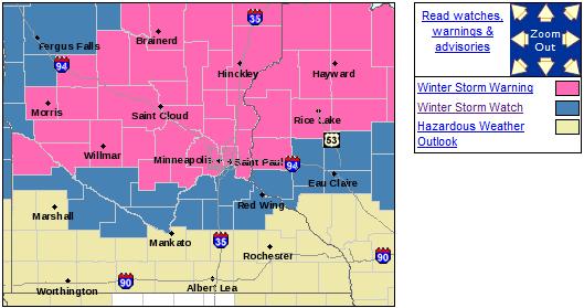
Winter Storm Warning posted for tonight and Sunday.
"Plowable" snowfall likely in the metro; right now I'm thinking 2-5" from late tonight into midday Sunday.
Probably "Plowable"
"Paul, spare me the weather-babble. How many
inches of snow in my yard by noon Sunday. Please be precise." Right. The
only thing harder than pinpointing a tornado touchdown is calculating,
down to the inch, how much snow will fall.
My favorite college professor bemoaned the utter
futility of giving inch amounts. He suggested 3 flavors of snowfalls:
nuisance (enough to slow things down a bit), "plowable"
(self-explanatory), and crippling, where everything shuts down.
I would put Sunday morning's snow in the
plowable range. And for purists who need their diet of inches, I'm
thinking 2-4 inches in the immediate metro, 5 inches north metro, maybe 8
inches Brainerd and over a foot for Duluth. Hey, it's human nature: if I
predict 2-4, you'll probably remember 4. Yes, we all like to round up.
Today will be the better travel day; a 7-10 hour burst of snow from late tonight through midday Sunday.
Leave extra time to get around tomorrow. This is
the first legitimate "storm", and we're all a wee bit rusty driving on
snow.
We may get our white Christmas after all; no big thaws in
sight thru December 25. A couple more inches may fall in 7 days.
Models, maps and alibis on the blog.
Winter Storm Warning. The watch has been upgraded to
a warning, which pretty much means it's imminent. What can possibly go
wrong? I know you're skeptical. I don't blame you. We'll get some snow -
not sure we'll see 6", but 2-4" seems like a fairly sure bet, with the
best chance of 5" or more north metro. Details from the local National
Weather Service:
URGENT - WINTER WEATHER MESSAGE
NATIONAL WEATHER SERVICE TWIN CITIES/CHANHASSEN MN
839 PM CST FRI DEC 7 2012

...LIGHT SNOW TAPERING OFF THIS EVENING...THEN A LARGER WINTER
STORM EXPECTED SATURDAY NIGHT INTO SUNDAY EVENING...

.THE FIRST OF TWO SYSTEMS HAS BEEN PRODUCING LIGHT SNOW ACROSS
MOST OF SOUTHERN MINNESOTA...BUT THE SNOW WAS TAPERING OFF. ACCUMULATIONS
THE REST OF THE NIGHT IN SOUTH CENTRAL MINNESOTA WILL BE LESS
THAN ONE INCH.

IT APPEARS THE SECOND SYSTEM FOR THE WEEKEND WILL DEVELOP INTO A
WINTER STORM. A WINTER STORM WARNING IS IN EFFECT NORTH OF A LINE
FROM MADISON MINNESOTA TO THE TWIN CITIES AND LADYSMITH WISCONSIN SATURDAY
NIGHT THROUGH SUNDAY EVENING. SNOW WILL SPREAD INTO WESTERN
MINNESOTA BY EARLY SATURDAY EVENING...AND THEN PUSH EAST...ACROSS
EASTERN MINNESOTA INTO WEST CENTRAL WISCONSIN BY LATE SATURDAY
EVENING. THE SNOW COULD BE HEAVY AT TIMES. SNOWFALL ACCUMULATIONS
IN THE WINTER STORM WARNING AREA WILL RANGE FROM 5 TO 8
INCHES...WITH THE HIGHEST TOTALS NORTHEAST OF INTERSTATE 94.

A WINTER STORM WATCH REMAINS IN EFFECT FOR A PORTION OF SOUTHERN
MINNESOTA INTO WEST CENTRAL WISCONSIN...FROM GRANITE FALLS AND REDWOOD
FALLS TO RED WING...THEN TO EAU CLAIRE AND CHIPPEWA FALLS WISCONSIN.
SNOWFALL AMOUNTS IN THE WINTER STORM WATCH AREA COULD REACH 6
INCHES...IF THE STORM SLIDES A LITTLE SOUTH.
* near blizzard conditions possible over parts of western and southern Minnesota Sunday.
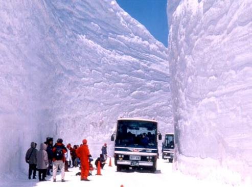
Prediction: We Will Not See This Much Snow. This
file photo was taken in northern Japan. Surreal. Yes, this would qualify
as a crippling snowfall. And no, we won't see quite this much. Not yet.
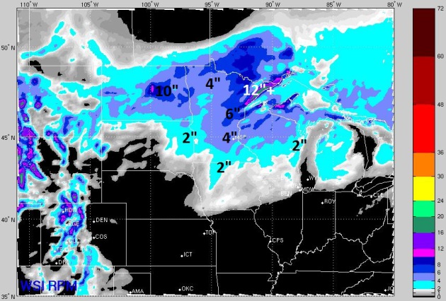
WSI RPM Model. The high-res 12km RPM model from WSI
Corporation continues to show some 4" amounts near MSP, with 6-8"
possible from Lake Mille Lacs to the Iron Range, maybe a foot of snow
along the North Shore of Lake Superior.
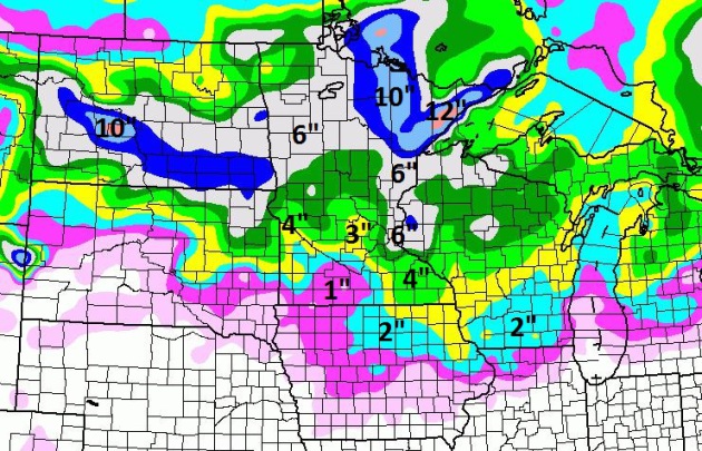
12z NAM Model:
More Impressive.
NOAA's latest NAM model is hinting that the eastern suburbs may pick up
almost twice as much snow as the far western suburbs; some 3-6" amounts
predicted across the metro area, lake effect and orographic lifting
spiking snowfall amounts up near Two Harbors and Lutsen. Gentlemen (and
women), start your snowmobiles.
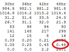
NAM Guidance. The 00z model shows a total of .48", which would translate into about 3-5" of snow by midday Sunday.
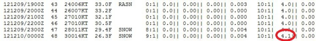
Bufkit Analysis.
NOAA's Bufkit tool, which does a good job of isolating snowfall
amounts, shows a couple hours of rain mixing in at the height of the
storm Sunday morning. That would obviously keep amounts a bit lower.
Bufkit shows a storm total of 4.1" in the MSP metro area.
ECMWF Model. I keep wondering: what can possibly go
wrong, and what time? Will the storm track farther north, pushing the
moderate snow shield toward Mille Lacs and Hinckley? Will dry air get
sucked into the circulation (the dreaded "dry tongue"?) We're still in a
nagging drought, and that's always in the back of my mind. The
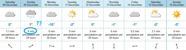
ECMWF (European) prints out only 6 mm. of liquid Sunday, about .26
inches of precipitation, which would imply closer to 2 or 3" of slushy
snow on the metro. Place your bets. I'm still thinking 2-5" by midday
Sunday, just enough to shovel and plow.
Record Snow Drought For Chicago? WGN-TV weather
legend Tom Skilling reports that, as of Sunday, Chicago will have gone
280 days without measurable snow, an all-time record for the Windy City.
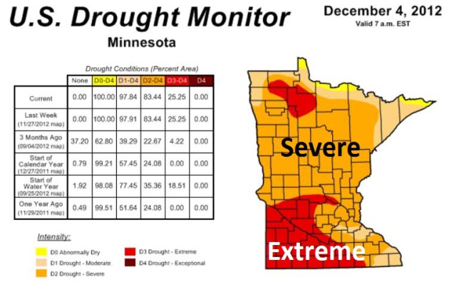
Growing Concern About Minnesota's Drought. Here's an excerpt from a recent update from Greg Spoden, Minnesota State Climatologist:
- Across Minnesota, snow cover is sparse to
nonexistent. At all locations, the present snow depth is below the
historical median.
- Stream discharge values are very low at a
number of Minnesota reporting locations. At many sites, stream flow
ranks below the 10th percentile when compared with historical data for
this time of year.
- Soil moisture measurements made during
November at University of Minnesota Research and Outreach Centers
indicate extraordinarily dry conditions in the soil profile. Ample
early-spring rains are critically needed to replenish soil moisture
reserves before the commencement of the 2013 growing season.
-
It is reasonable to assume that the
present drought status will remain relatively unchanged throughout the
winter. The historical average precipitation over the next three months
is a meager two and one-half inches and the topsoil will soon be sealed
by frost. Without abundant spring rains, a number of critical drought
issues involving public water supply, agriculture, horticulture, and
tourism will rapidly emerge in the spring.
* updated (December 4) U.S. Drought Monitor is
here.
2/3rds of America remains in drought. The New York Times has a good overview
here.
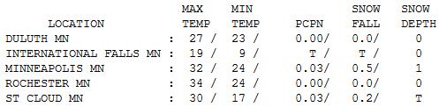
Flakey Appetizer. A half inch of snow fell yesterday
in the metro, just a light coating up in St. Cloud, from a weak
disturbance out ahead of the main storm. Highs were closer to average,
ranging from 19 at International Falls to 30 St. Cloud, 32 Twin Cities
and 34 at Rochester.
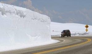
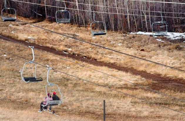
Very Plowable. No, we won't see this much snow either. But a guy can dream...
Paul's Conservation Minnesota Outlook for the Twin Cities and all of Minnesota:
TODAY: Clouds increase during the day, better travel day. Winds: SE 10-15. High: 35
SATURDAY NIGHT: Winter Storm Warning. Snow likely. Roads become slushy and slick late. Low: 30
SUNDAY: Treacherous travel into midday. Snow tapers to flurries. 2-5" metro snow, 5-10" possible up north. High: 32
MONDAY: Ah, winter! Numbing sun. Wind chill: -10. Low: 6. High: 15
TUESDAY: Partly sunny, not as harsh. Low: 8. High: 26
WEDNESDAY: Intervals of sun, "milder". Low: 17. High: 33
THURSDAY: Stubborn clouds, a bit cooler. Low: 25. High: 31
FRIDAY: Still drab and gray. Low: 18. High: 29
* a couple inches of additional snow may fall next Saturday, a week from today.
Climate Stories...
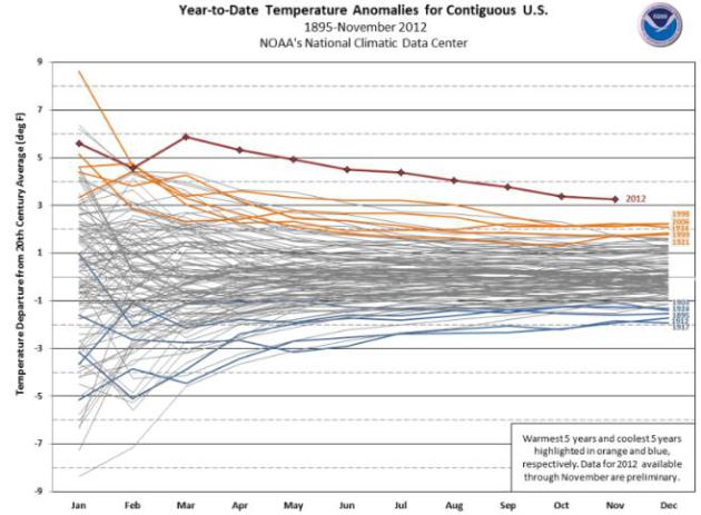
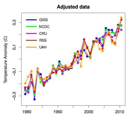
2012: Still Off The Scale. Here's an update from
NOAA NCDC on what will be the warmest year ever observed for the USA. I know - another coincidence. They're piling up: "
This
time series also shows the 2012 year-to-date temperature through
November. Outcome scenarios based on persistence of temperature for
December, the remaining month of 2012, are shown. The January-November
2012 contiguous U.S. average temperature was 57.1°F, 3.3°F above
average. The nationally-averaged temperature for December 2012 would
need to be more than 1.0°F colder than the coldest December (1983) for
2012 not to be the new record warmest year. The data for 2012 are
preliminary."
Global Warming Gives Ski Industry Chills.
Live Science has the story; here's an excerpt: "...
POW and the Natural Resources Defense Council have issued a report, "Climate Impacts on the Winter Tourism Economy in the United States,"
detailing the numerous effects that global warming is expected to have
on the $12.2 billion U.S.ski and snowmobile winter sports industry,
which supports an estimated 211,900 jobs nationwide. "Winter as we know
it is on borrowed time," Elizabeth Burakowski, a co-author of the
POW/NRDC report, told The New York Times. The 2011/2012 winter season was the fourth-warmest on record since 1896 and had the third-lowest snow cover since record-keeping began in 1966...."
Photo credit above: "
Ski resorts are expected to suffer from global warmng." Marcin Moryc, Shutterstock.
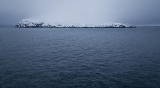
Global Warming Good News For Russian Shipping.
Marketplace has the story; here's the introduction: "
There's
been a breakthrough in the shipping industry, and a milestone in the
story of global warming. A large tanker named Ob River has just sailed
eastwards from Northern Europe to Japan through the Arctic Ocean. This
is the first time a ship of this type has completed the voyage. It's
bad news for the planet. It shows how far the north polar ice cap is
melting. But it also shows how climate change is creating new
commercial opportunities -- especially for the Russians. Ob River is not
the first cargo ship to make the crossing, but it is the first big
tanker to do so carrying Liquefied Natural Gas -- perhaps the first of
many. Gunnar Sandar of the Norwegian Polar Institute says global warming
is creating a viable new trade route through the Arctic Ocean..."
Photo credit: "
Melting ice means a Russian gas company can now send tankers to Japan through the Arctic Ocean, instead of the Suez Canal." Tim Lucas - Creative Commons.
Projection: The IPCC 2007 assessment projected a
worst-case temperature rise of 4.3° to 11.5° Fahrenheit, with a high
probability of 7.2°F.
Reality: We are currently on track for a rise of
between 6.3° and 13.3°F, with a high probability of an increase of
9.4°F by 2100, according to the Massachusetts Institute of Technology.
Other modelers are getting similar results, including a
study published earlier this month by the Global Carbon Project consortium confirming the likelihood of a 9ºF rise.
* excerpt above from
Scientific American. Details below.
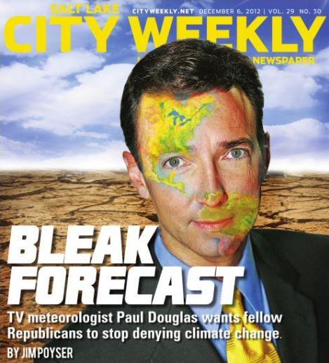
"Bleak Forecast". The recent interview I gave to Jim Poyser at NUVO in Indianapolis is being picked up by other publications, including Utah's
City Weekly.
Yes, my dermatologist is calling 911 right now. I've never had Doppler
on my face, even worse than egg on my face. Here's an excerpt: "...
I'm
not saying we don't take advantage of our natural resources. The
message I'm trying to get out is that by fixating exclusively on fossil
fuels, not only are we endangering future generations, we are
endangering our competitiveness downt he road. Because there is no
debate about climate change in Europe or China. They are moving forward
with clean alternatives to creating energy. If we totally focus on
mining and drilling and extracting ever last bit of carbon at the
exclusion of solar and wind and geothermal and battery technology and
everything else that's out there, we are going to be crippled as a
country, competitively..."
Report: Global Warming Hits Utah's Ski Industry Hard.
A preview of coming attractions here in Minnesota? I hope not, but
there's little doubt that snowfall is becoming increasingly fickle,
sporadic, and unreliable. No, it's not your father's or grandfather's
winter. Here's an excerpt from
The Salt Lake Tribune: "
Every
lean-snow winter batters Utah and its $1 billion-a-year ski industry,
according to an economic study on global warming released Thursday by
the Natural Resources Defense Council. Comparing snowfall to visitation
records since 1999, the NRDC report said Utah resorts attracted 14
percent fewer skiers in the driest winter compared to the snowiest.
That difference cost the state $87 million in revenue and 1,000 jobs,
it said..."
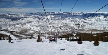
Photo credit above: (Steve Griffin | The Salt Lake Tribune) "
Skiers
ride the lower lift at Park City Mountain Resort on Thursday, Dec. 6,
2012. A new report warns that global warming will make low-snow years
more prevalent and batter the ski industry."
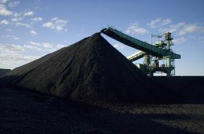
World's Largest Mining Company Admits Climate Change Is Real. Here's a clip from
theenergycollective.com: "
Sure,
those of us who call ourselves environmentalists take those as truths,
but a major coal company? Yet that’s exactly what the Australian BHP
Billiton, the world’s largest mining company,
has just copped to. Explaining the company’s decision to retrofit one
if its coal-exporting facilities against significant weather events,
BHP Billiton executive Marcus Randolph was quoted as
saying, “As we see more cyclone-related events ... the vulnerability
of one of these facilities to a cyclone is quite high. So we built a
model saying this is how we see this impacting what the economics would
be and used that with our board of directors to rebuild the facility
to be more durable to climate change....”
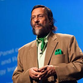
How The IPCC Underestimated Climate Change. "Those
alarmist scientists?" It turns out climate scientists, as a rule,
underestimated the rate of warming and subsequent outbreaks of severe
weather (intense rains, more severe hurricanes, etc). Here's an excerpt
from
Scientific American: "
Scientists
will tell you: There are no perfect computer models. All are
incomplete representations of nature, with uncertainty built into them.
But one thing is certain: Several fundamental projections found in
Intergovernmental Panel on Climate Change reports have consistently
underestimated real-world observations, potentially leaving world
governments at doubt as to how to guide climate policy..."
Photo credit above: "
Today, ice
loss in Greenland and Antarctica is trending at least 100 years ahead
of projections compared to IPCC's first three reports. Pictured:
Rajenda Pachauri, chair of the Intergovernmental Panel on Climate
Change (IPCC)."
Image: Flickr/kk+
Accelerating Warming Driving Arctic Into New Volatile State. Meteorologist Andrew Freedman at
Climate Central has the story; here's an excerpt: "...
Since
the report card effort began in 2006, each iteration has issued more
shrill alarms about the pace and extent of the changes taking place in
the Arctic. This year’s report is noteworthy for what it says about the
acceleration of climate change in the Far North. Despite air
temperatures that averaged nearly equal to the average for the past
decade -- which is warmer than the 30-year average -- 2012 saw the most
extensive loss of Arctic sea ice ever seen in the 33-year satellite record.
When the melt season finally ended in late September, the Arctic Ocean
managed to hold onto less than half of the average sea ice extent seen
during the 1979-to-2000 period..."
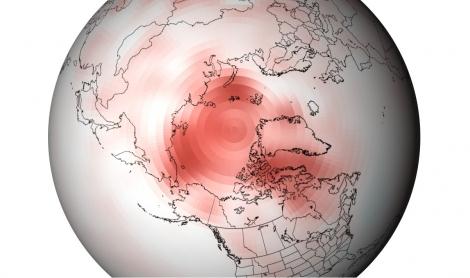
Image credit above: "
Departure
from average of Arctic surface temperatures during the first decade of
the 21st century, as compared to the 1971-2000 average. This map
illustrates that no part of the Arctic experienced cooler than average
conditions during this period." Credit: NOAA.
Arctic Climate Change's Unglacial Pace. The story is from
The San Francisco Chronicle; here's an excerpt: "
The
Arctic's sea ice is shrinking, Greenland's ice cover is melting
faster, areas of once-frozen tundra in Alaska are alive with plant
growth, and wildfires during Southern summer heat waves are carrying
soot to darken northern snowfields and speed the melting. And a
year-end report from more than 140 scientists around the world concludes
that climate change caused some of the strongest-ever environmental
effects on the Arctic this year and the pace of change is far
from slowing..."
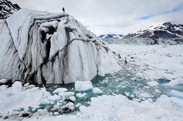
Photo credit above: "
A technician stands on an iceberg in
Columbia Bay, Alaska, during filming of "Chasing Ice," which follows a
photographer recording the changing Arctic." Photo: James Balog, Associated Press / SF
Climate Change Risk Looms As 2 Degree Limit Now Unlikely. Here's an excerpt from
The Energy Collective: "
With global greenhouse hitting a record high in 2011 and
2012 on track to break that record, the prospects of limiting average
atmospheric global warming to within a 2 degree Celsius rise from
pre-industrial is now considered unlikely according to the Emissions Gap Report
from the U.N. Environment Programme. The report warns that even if
nations adhere to their strickest current reduction goals, CO2 output
won’t be reduced in time to stop runaway global warming in the coming
decades.Scientists from the Global Carbon Project (GCP)
estimate CO2 emissions from burning fossil fuels in 2012 will exceed
1990 levels by as much as 58 percent. In 2011 38.2 billion tons of CO2
was pumped in the atmosphere – equal to 2.4 million pounds every second...."


No comments:
Post a Comment