46 F. high in the Twin Cities Thursday.
30 F. average high for December 6.
19 F. high temperature on December 6, 2011.
Trace of rain reported yesterday.
Coating - 1" slush possible tonight.
1-3" slushy snow possible Saturday night (most amounts north metro).
Breaking News?
What has happened to us? When I arrived back in
1983 a forecast of 6 inches of snow was "no big deal". Yes, there will
be school tomorrow. I bragged out loud about Minnesota's state of the
art snow removal. During the 90's three inches of snow was a lead story.
Really? When did we become Atlanta? Now a lousy inch leads the news.
"Uh oh, I smell a tough commute".
As old fashioned winters & big snows become
the equivalent of an albino squirrel - each feeble burst of snow takes
on new urgency. At this rate we'll become Washington D.C., where the
mention of "flurries" causes a run on grocery stores.
Someone call MnDOT, FEMA and The National Guard:
a coating of slush is possible tonight; a mix of rain, ice and snow may
drop 1-3" of oatmeal-like slush on our heads Saturday night. Looking
out 2 weeks - any snow will come in dribs and drabs.
Bitter air is building over Alaska and the Yukon. Maybe we'll get smacked before Christmas. Yes, we are due.
No moisture is bad news. Minnesota Climate Chief
Greg Spoden: "Without abundant spring rains a number of critical
drought issues involving public water supply, agriculture, horticulture,
and tourism will rapidly emerge in the spring".
There's your breaking news.
How much snow? Welcome to the
world of dueling models. Which one to believe, and when? Great question.
We look for continuity, some agreement from model to model, and run to
run. Are they converging on one solution? If so our confidence level
goes up. A quick half inch or inch of slushy snow is possible tonight, a
better chance of a couple inches of slushy snow Saturday night and
early Sunday; more north metro, less south metro.
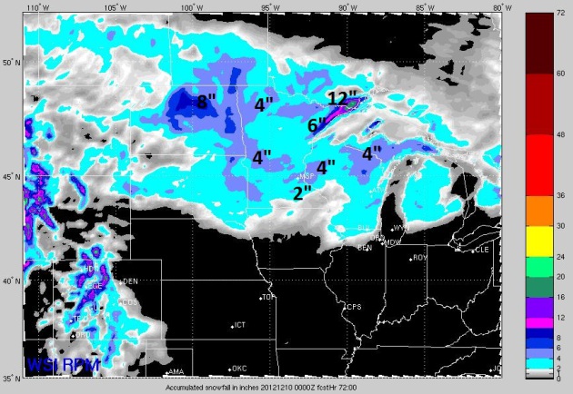
WSI RPM Model. Here is one of the more reliable
models we use; WSI's exclusive 12 km. RPM model. The latest guidance
shows some 2-4" amounts in the metro area, most of that coming Saturday
night and early Sunday. Temperatures may be just above freezing Saturday
night (lowest few hundred feet of the atmosphere), which should mean a
wet, slushy snow, possibly even a period of sleet, which would keep inch
amounts down somewhat. That said, my confidence level is increasing
that we may actually wake up to a coating of white Sunday morning. I
know. Shocking.
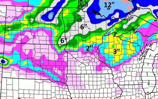
NAM Model. Another fairly reliable model: NOAA's
NAM, which shows less snow than the RPM. I'm not discounting this,
considering we're in a drought. My expectations (rain, ice and snow) are
unusually low, due to the dry rut we're stuck in. Sadly, the drought is
another factor to weigh. There's little doubt that snowfall amounts
will be higher north/west of the MSP metro Saturday night into early
Sunday.
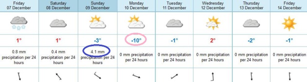
ECMWF Model. The fact that the usually reliable
European model is only printing out 4.1 mm of precipitation (early)
Sunday is another strike against significant snow. Don't you just love
metric? Me too. 4.1 mm translates into .16 inches of liquid. With
temperatures near 32-33 F late Saturday night that equates into a
whopping inch or two. With drought (and ECMWF) in mind, I'm discounting
the raw NAM numbers somewhat, going 1-3" of slush Saturday night, an
inch south metro, closer to 3" near Anoka, Elk River and Monticello.
Record Snow Drought For Chicago? WGN-TV weather
legend Tom Skilling reports that, as of Sunday, Chicago will have gone
280 days without measurable snow, an all-time record for the Windy City.
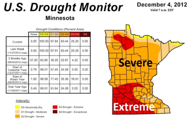
Growing Concern About Minnesota's Drought. Here's an excerpt from a recent update from Greg Spoden, Minnesota State Climatologist:
- Across Minnesota, snow cover is sparse to
nonexistent. At all locations, the present snow depth is below the
historical median.
- Stream discharge values are very low at a
number of Minnesota reporting locations. At many sites, stream flow
ranks below the 10th percentile when compared with historical data for
this time of year.
- Soil moisture measurements made during
November at University of Minnesota Research and Outreach Centers
indicate extraordinarily dry conditions in the soil profile. Ample
early-spring rains are critically needed to replenish soil moisture
reserves before the commencement of the 2013 growing season.
- It is reasonable to assume that the
present drought status will remain relatively unchanged throughout the
winter. The historical average precipitation over the next three months
is a meager two and one-half inches and the topsoil will soon be sealed
by frost. Without abundant spring rains, a number of critical drought
issues involving public water supply, agriculture, horticulture, and
tourism will rapidly emerge in the spring.
* updated (December 4) U.S. Drought Monitor is
here.
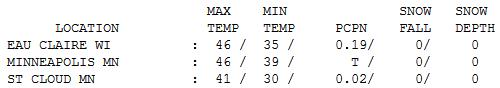
"Octember". 46 F. on the 6th day of December,
roughly 2 weeks away from the Winter Solstice, is nothing to sneeze at,
or shiver over, for that matter. Highs were 15-20 F. above average
statewide. Eau Claire picked up .19" of rain.
Paul's Conservation Minnesota Outlook for the Twin Cities and all of Minnesota:
TODAY: Clouds increase and thicken. Winds: NE 3-8. High: 33
FRIDAY NIGHT: A little light snow; slushy coating possible. Low: 26
SATURDAY: Mostly cloudy with sprinkles or flurries. High: 35
SATURDAY NIGHT: Snow may mix with a little sleet. 1-3 inches of slush? Low: 28
SUNDAY: Icy, slushy start. Snow quickly tapers to flurries, turning windy and colder. High: 31
MONDAY: A real December day. Some sun - numbing breeze. Low: 9. High: 19
TUESDAY: Patchy clouds, not as cold. Low: 11. High: 29
WEDNESDAY: Milder breeze. Snow far northern Minnesota. Low: 18. High: 34
THURSDAY: More clouds, no weather drama. Low: 21. High: 25
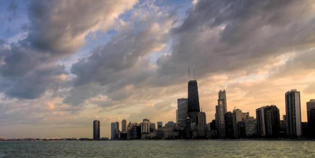
* photo above courtesy of Michael Busch.
Climate Stories...
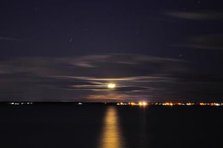
Projection: The IPCC 2007 assessment projected a
worst-case temperature rise of 4.3° to 11.5° Fahrenheit, with a high
probability of 7.2°F.
Reality: We are currently on track for a rise of
between 6.3° and 13.3°F, with a high probability of an increase of
9.4°F by 2100, according to the Massachusetts Institute of Technology.
Other modelers are getting similar results, including a
study published earlier this month by the Global Carbon Project consortium confirming the likelihood of a 9ºF rise.
* excerpt above from
Scientific American. Details below.
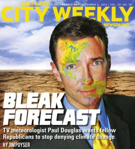
"Bleak Forecast". The recent interview I gave to Jim Poyser at NUVO in Indianapolis is being picked up by other publications, including Utah's
City Weekly.
Yes, my dermatologist is calling 911 right now. I've never had Doppler
on my face, even worse than egg on my face? Here's an excerpt: "...
I'm
not saying we don't take advantage of our natural resources. The
message I'm trying to get out is that by fixating exclusively on fossil
fuels, not only are we endangering future generations, we are
endangering our competitiveness downt he road. Because there is no
debate about climate change in Europe or China. They are moving forward
with clean alternatives to creating energy. If we totally focus on
mining and drilling and extracting ever last bit of carbon at the
exclusion of solar and wind and geothermal and battery technology and
everything else that's out there, we are going to be crippled as a
country, competitively..."
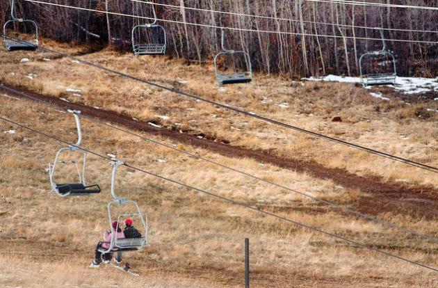
Report: Global Warming Hits Utah's Ski Industry Hard.
A preview of coming attractions here in Minnesota? I hope not, but
there's little doubt that snowfall is becoming increasingly fickle,
sporadic, and unreliable. No, it's not your father's or grandfather's
winter. Here's an excerpt from
The Salt Lake Tribune: "
Every
lean-snow winter batters Utah and its $1 billion-a-year ski industry,
according to an economic study on global warming released Thursday by
the Natural Resources Defense Council. Comparing snowfall to visitation
records since 1999, the NRDC report said Utah resorts attracted 14
percent fewer skiers in the driest winter compared to the snowiest.
That difference cost the state $87 million in revenue and 1,000 jobs,
it said..."
Photo credit above: (Steve Griffin | The Salt Lake Tribune) "
Skiers
ride the lower lift at Park City Mountain Resort on Thursday, Dec. 6,
2012. A new report warns that global warming will make low-snow years
more prevalent and batter the ski industry."
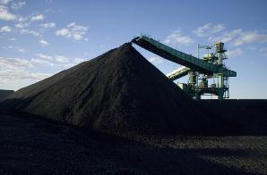
World's Largest Mining Company Admits Climate Change Is Real. Here's a clip from
theenergycollective.com: "
Sure,
those of us who call ourselves environmentalists take those as truths,
but a major coal company? Yet that’s exactly what the Australian BHP
Billiton, the world’s largest mining company,
has just copped to. Explaining the company’s decision to retrofit one
if its coal-exporting facilities against significant weather events,
BHP Billiton executive Marcus Randolph was quoted as
saying, “As we see more cyclone-related events ... the vulnerability
of one of these facilities to a cyclone is quite high. So we built a
model saying this is how we see this impacting what the economics would
be and used that with our board of directors to rebuild the facility
to be more durable to climate change....”
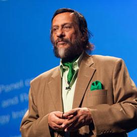
How The IPCC Underestimated Climate Change. "Those
alarmist scientists?" It turns out climate scientists, as a rule,
underestimated the rate of warming and subsequent outbreaks of severe
weather (intense rains, more severe hurricanes, etc). Here's an excerpt
from
Scientific American: "
Scientists
will tell you: There are no perfect computer models. All are
incomplete representations of nature, with uncertainty built into them.
But one thing is certain: Several fundamental projections found in
Intergovernmental Panel on Climate Change reports have consistently
underestimated real-world observations, potentially leaving world
governments at doubt as to how to guide climate policy..."
Photo credit above: "
Today, ice
loss in Greenland and Antarctica is trending at least 100 years ahead
of projections compared to IPCC's first three reports. Pictured:
Rajenda Pachauri, chair of the Intergovernmental Panel on Climate
Change (IPCC)."
Image: Flickr/kk+
Accelerating Warming Driving Arctic Into New Volatile State. Meteorologist Andrew Freedman at
Climate Central has the story; here's an excerpt: "...
Since
the report card effort began in 2006, each iteration has issued more
shrill alarms about the pace and extent of the changes taking place in
the Arctic. This year’s report is noteworthy for what it says about the
acceleration of climate change in the Far North. Despite air
temperatures that averaged nearly equal to the average for the past
decade -- which is warmer than the 30-year average -- 2012 saw the most
extensive loss of Arctic sea ice ever seen in the 33-year satellite record.
When the melt season finally ended in late September, the Arctic Ocean
managed to hold onto less than half of the average sea ice extent seen
during the 1979-to-2000 period..."
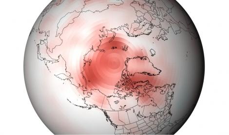
Image credit above: "
Departure
from average of Arctic surface temperatures during the first decade of
the 21st century, as compared to the 1971-2000 average. This map
illustrates that no part of the Arctic experienced cooler than average
conditions during this period." Credit: NOAA.
Arctic Climate Change's Unglacial Pace. The story is from
The San Francisco Chronicle; here's an excerpt: "
The
Arctic's sea ice is shrinking, Greenland's ice cover is melting
faster, areas of once-frozen tundra in Alaska are alive with plant
growth, and wildfires during Southern summer heat waves are carrying
soot to darken northern snowfields and speed the melting. And a
year-end report from more than 140 scientists around the world concludes
that climate change caused some of the strongest-ever environmental
effects on the Arctic this year and the pace of change is far
from slowing..."
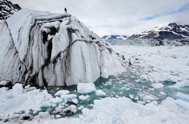
Photo credit above: "
A technician stands on an iceberg in
Columbia Bay, Alaska, during filming of "Chasing Ice," which follows a
photographer recording the changing Arctic." Photo: James Balog, Associated Press / SF
Climate Change Risk Looms As 2 Degree Limit Now Unlikely. Here's an excerpt from
The Energy Collective: "
With global greenhouse hitting a record high in 2011 and
2012 on track to break that record, the prospects of limiting average
atmospheric global warming to within a 2 degree Celsius rise from
pre-industrial is now considered unlikely according to the Emissions Gap Report
from the U.N. Environment Programme. The report warns that even if
nations adhere to their strickest current reduction goals, CO2 output
won’t be reduced in time to stop runaway global warming in the coming
decades.Scientists from the Global Carbon Project (GCP)
estimate CO2 emissions from burning fossil fuels in 2012 will exceed
1990 levels by as much as 58 percent. In 2011 38.2 billion tons of CO2
was pumped in the atmosphere – equal to 2.4 million pounds every second...."


No comments:
Post a Comment