39 F. high in the Twin Cities Saturday.
27 F. average high for December 15.
37 F. high on December 15, 2011.
.42" rain fell on KMSP Saturday.
1/10th of an inch of snow fell yesterday as of 7 pm.
27 F. average high for December 15.
37 F. high on December 15, 2011.
.42" rain fell on KMSP Saturday.
1/10th of an inch of snow fell yesterday as of 7 pm.
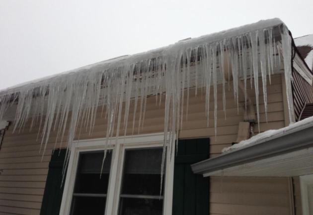
"March-ember"
With all the unsettling weather of recent years,
were you really surprised it rained yesterday, 6 days before the Winter
Solstice?
Me neither.
2012: probably the warmest on record for
Minnesota. Flowers blooming in March. July was the second warmest
month since 1872. Only one month the entire year was cooler than average
(October).
A foot of snow a week ago was reassuring (for winter fans) but the patient continues to run a low-grade
fever.
So what?
Think how a couple of extra degrees can leave you
feeling miserable, with flu and aches. 2012 may wind up 5 F. warmer than
average in the Twin Cities. The Symphony of The Seasons is still
playing slightly out of tune - that's why the snow in your yard yesterday
looked like week-old oatmeal.
Flurries taper; a few lucky towns having picked up 1-2 inches of snow overnight. Skies clear
later today; seasonably chilly weather into midweek. Thursday's storm will
probably track south and east of Minnesota, dumping heavy snow from the Quad Cities to Madison and Green Bay. Cold, dry weather
prevails from Friday into Christmas (teens and 20s for highs - lows in single
digits).
Here we go, stumbling into another abbreviated Minnesota winter.
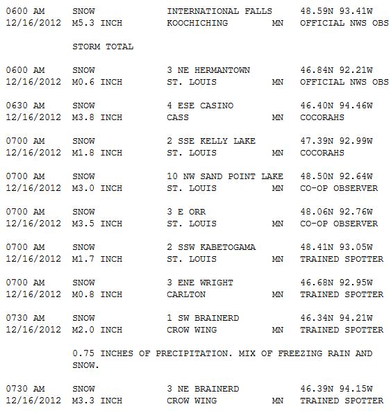
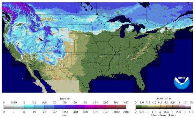
Saturday Snowfall.
Although just about all rain in the Twin Cities, Brainerd picked up a
2-4" icy mix of freezing rain followed by snow. Over 5" of new snow
caked International Falls. More details from NOAA here.

328 Days without a Sub-Zero Temperature in Rochester MN – All Time
Record in Jeopardy. Rochester International Airport has not fallen below
zero since January 21 2012 -12 degrees. This 328 day stretch ties a
similar stretch in 1999 January 26-December 19 for the third longest
stretch of days without falling below zero. This current streak is just 5
days from the record of 333 days set back in 1987 January 27 through
December 25. With no sub-zero temperatures in forecast for next week,
this record will likely bebroken on Thursday, December 20th. Source: NOAA.

ECMWF: Quiet Week.
The latest European model shows a few flurries by Wednesday,
substantially colder weather by next weekend with highs in the teens and
low 20s. Thursday's storm is a no-show, sliding off south/east of MSP.
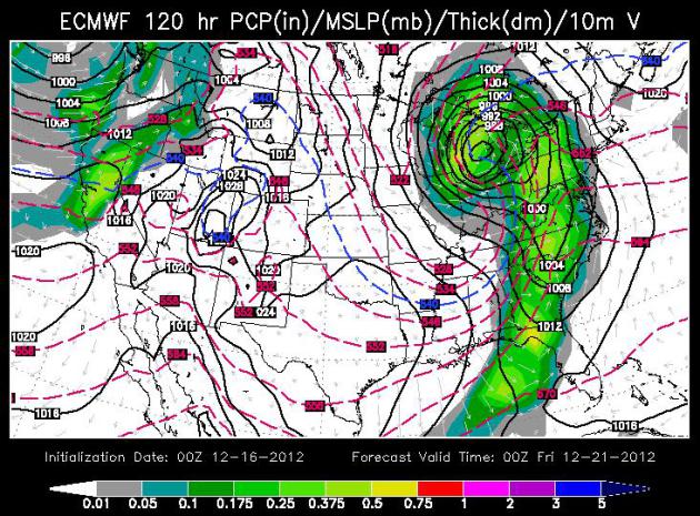
Big Snow for Chicago? Not Here.A
very significant storm spins up later this week, along the leading edge
of a colder surge. Heavy snow is possible from the Quad Cities to
Madison, Milwaukee and Chicago by Thursday, a warm rain (and a few
severe T-storms) pushing into the eastern seaboard? Like something out
of March. ECMWF Map: valid Thursday evening, courtesy of WSI
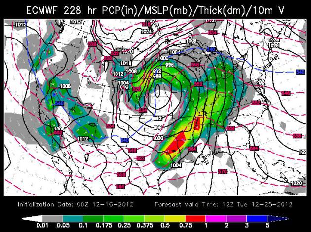
Christmas
Slush. It's pretty far out on the horizon, but just for laughs and
giggles I thought I'd include the outlook for Christmas Morning, showing
a possible severe T-storm outbreak from Dallas and Houston to Memphis,
with a storm winding up over the Upper Midwest, possibly a rain/snow mix
for much of Minnesota, with heavier snow (only) for the Dakotas - a
rather turbulent map,and if it verifies, weather will almost certainly
be a factor for Christmas travel. 12z December 25 ECMWF (European) map from WSI.
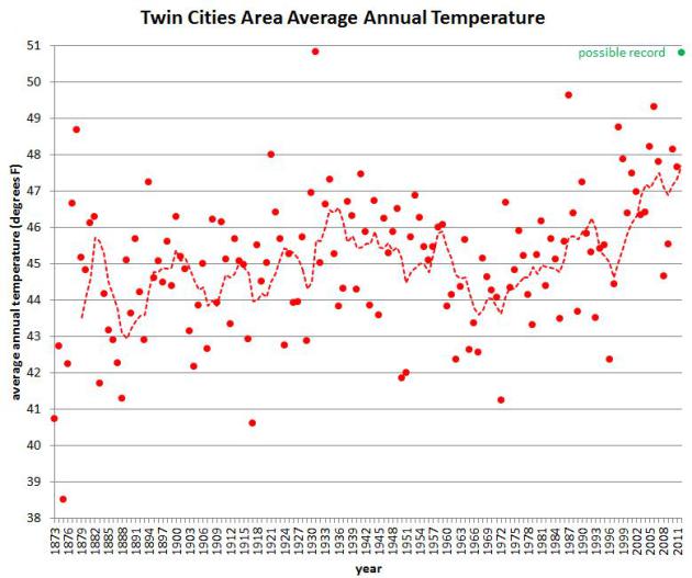
2012: Warmest Year On Record for the Twin Cities? Here's an excerpt of an e-mail I received from Minnesota State Climatologist Greg Spoden: "As
I'm sure you are aware, Twin Cities temperatures in 2012 have been
pervasively warm. March 2012 was the warmest March on record by a large
margin. July 2012 was the second warmest July (and the second warmest of
any month) of the modern record. October was the only below-normal
temperatures month of the year. As the calendar year comes to a close,
there exists the potential to break the record for the warmest annual
average temperature found in the modern Twin Cities climate data set
(1872-2012). Should the December monthly average temperature finish
above 24.0 degrees, a new calendar year average temperature record will
be established. This will require that the monthly average temperature
exceeds the December normal average temperatures (19.7 degrees) by more
than 4.3 degrees. Given December temperatures reported thus far, along
with the outlooks for the second half of December, such a scenario
appears to be plausible."
Graphic above: average Twin Cities temperatures since 1872, courtesy of the Minnesota Climate Office.
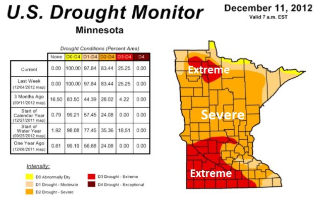
-The portion of the contiguous U.S. in the worst category – D4, or exceptional drought – remained virtually unchanged at 6% (rounded) for the eighteenth consecutive week (August 14 – December 11).
-Hay in drought fell slightly to 64%, but has been at or above 60% for 23 consecutive weeks – since July 10.
-Cattle in drought was unchanged at 73%, and has been greater than two-thirds of the domestic inventory for 23 consecutive weeks (July 10 – December 11).
-Winter wheat in drought was down slightly to 63%, although the hard red winter wheat belt – especially from South Dakota to Texas – remains deeply entrenched in drought."
* the latest Minnesota Drought Monitor from NOAA is here.
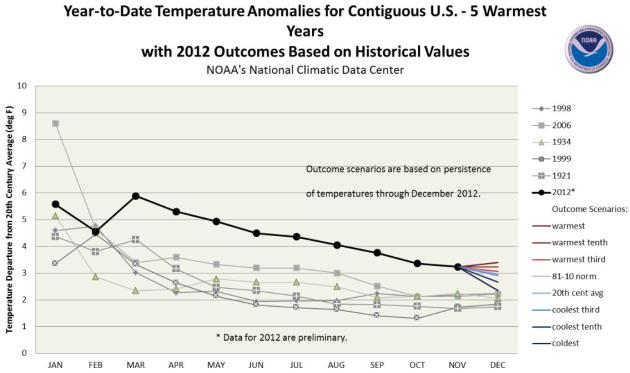
- The January-November period was the warmest first 11 months of any year on record for the contiguous United States. The national temperature of 57.1°F was 3.3°F above the 20th century average, and 1.0°F above the previous record warm January-November of 1934. During the 11-month period, 18 states were record warm and an additional 24 states were top ten warm.
- It appears virtually certain that 2012 will surpass the current record (1998, 54.3°F) as the warmest year for the nation. December 2012 temperatures would need to be more than 1.0°F colder than the coldest December (1983) for 2012 to not break the record.

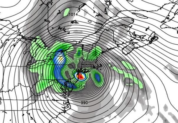
OPPOSING VIEW: Our warnings were clear and effective
Why not? In the six weeks since Sandy struck, a lot of people in the forecasting community have been asking that question. The emerging answers suggest that, faced with a pair of unusual challenges from Sandy, government forecasters rose to one test and bungled the other..."
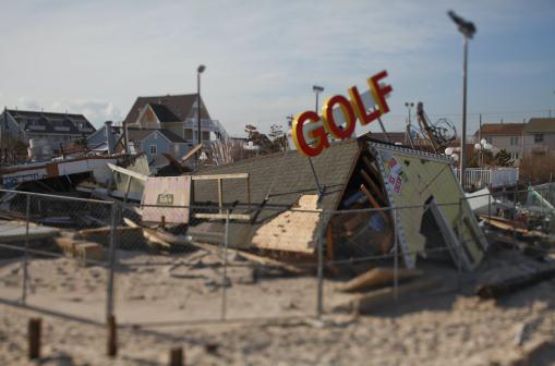
House lawmakers don't intend to introduce an emergency funding bill anywhere near as large as the $60 billion the Obama administration is seeking to help rebuild the Northeast after superstorm Sandy, saying the administration hasn't provided sufficient details to justify spending that amount, two senior GOP aides said Wednesday.
If the Republican-controlled House doesn't take up the measure this year, it would push debate on a large rebuilding bill into next year -- something New York and New Jersey officials have said they want to avoid..."
Photo credit: " A miniature golf course destroyed by Hurricane Sandy at Jenkinson's Boardwalk in Point Pleasant Beach, N.J., Nov. 28, 2012. A month after Hurricane Sandy wreaked havoc along the Jersey Shore, the area is slowly starting to recover. (Fred R. Conrad/The New York Times)
Paul's Conservation Minnesota Outlook for the Twin Cities and all of Minnesota
TODAY: Flurries taper early. Slow clearing by afternoon. Winds: NW 10-15. High: 32 (falling into the 20s)
SUNDAY NIGHT: Partly cloudy and chilly. Low: 18
MONDAY: More sun, cool breeze. High: 26
TUESDAY: Clouds, few flurries possible. Low: 15. High: 28
WEDNESDAY: Intervals of sun, a dry sky. Low: 18. High: 29
THURSDAY: Snow passes south/east of MN. Light snow or flurries possible over southeastern MN. Low: 17. High: 25
FRIDAY: Chilled sunlight - feels like December again. Low: 9. High: 21
SATURDAY: Cold blue sky. Good travel weather. Low: 7. High: 19
Climate Stories...
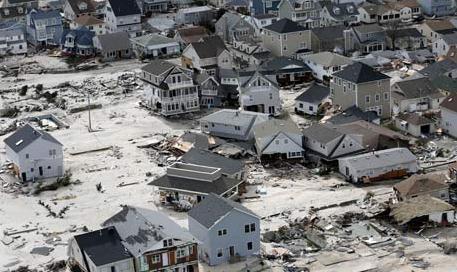
Photo credit: "Homes left in the wake of superstorm Sandy in Seaside Heights, New Jersey." Photograph: Mike Groll/AP
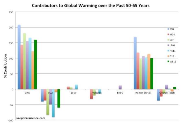
Image credit above: "Percent contributions of greenhouse gases (GHGs), sulfur dioxide (SO2), the sun, volcanoes, and El Niño Southern Oscillation (ENSO) to the observed global surface warming over the past 50-65 years according to Tett et al. 2000 (T00, dark blue), Meehl et al. 2004 (M04, red), Stone et al. 2007 (S07, green), Lean and Rind 2008 (LR08, purple), Huber and Knutti 2011 (HK11, light blue), Gillett et al. 2012 (G12, orange), and Wigley and Santer 2012 (WS12, dark green)."
* Global Warming is not due to the sun, according to leaked IPCC report. The U.K. Guardian has details.
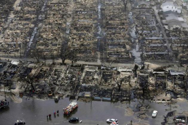
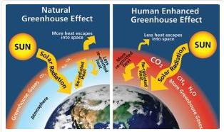
Image credit above: National Park Service, Will Elder
No comments:
Post a Comment