By Todd Nelson
I remember my late father telling me that time goes faster the older you get, but this seems ridiculous. I never really realized it until I had kids; you blink and their crawling, walking, talking and making their own decisions. I think I know what my New Year's Resolution will be this year: to stop and smell the roses a little more. "Yesterday's history, tomorrow's a mystery and today's a gift.
As we ring in the New Year, temperatures will bottom out at some of the coldest readings we've seen in nearly a year. The last time the Twin Cities (officially) went sub-zero was on January 21st, when the mercury dipped to -1F. We should have no problem surpassing that tonight as temperatures inch ever closer to the teens below zero.
Those who venture out around the stroke of midnight tonight will want to bundle up, the threat of turning into a frozen pumpkin has high probability for those who don't. Wind chill values will stay sub-zero for much of the day and settle in around the teens below zero as the calendar gets a new header: 2013!
A moisture-starved clipper arrives on Wednesday with a light coating of snow. Still no major shovel potential in sight. -Todd Nelson
________________________________________________________________________________________
Todd's Conservation MN Outlook for the Twin Cities and all of Minnesota:
NEW YEAR'S EVE: Cold as we round out 2012. High: 9. Winds: NW 5-10. Wind Chills: -5 to -10.
NEW YEAR'S EVE NIGHT: Fozen pumpkin potential as the clock strikes midnight. Low: -6. Wind Chills -10 to -20.
NEW YEAR'S DAY: Cold start to 2013! High: 13
WEDNESDAY: Clipper arrives, light coating of snow possible. Low: 5. High: 20.
THURSDAY: AM flurry. PM clearing trend. Low: 8. High: 17.
FRIDAY: Bright sun, quiet. Low: 5. High: 22.
SATURDAY: Good outdoor rink day. Low: 10. High: 24.
SUNDAY: Friday January thaw? Low: 14. High: 30.
______________________________________________________________________________________
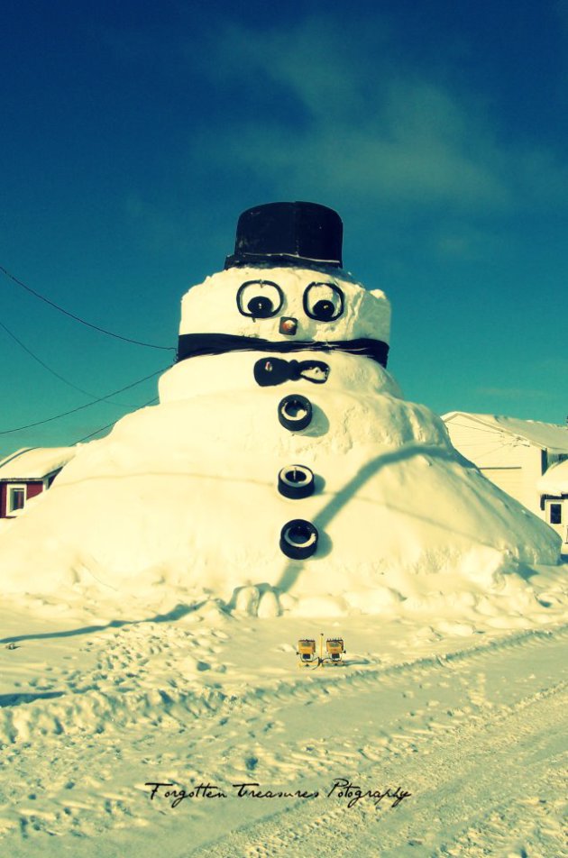
Champion, NY
Thanks to Forgotten Treasures Photography for the picture below. It's a monsterous snowman out of Champion, NY.
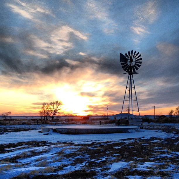
North Platte, NE
Thanks to @Hansen_77 for the beautiful sunset picture below out of North Platte, NE.
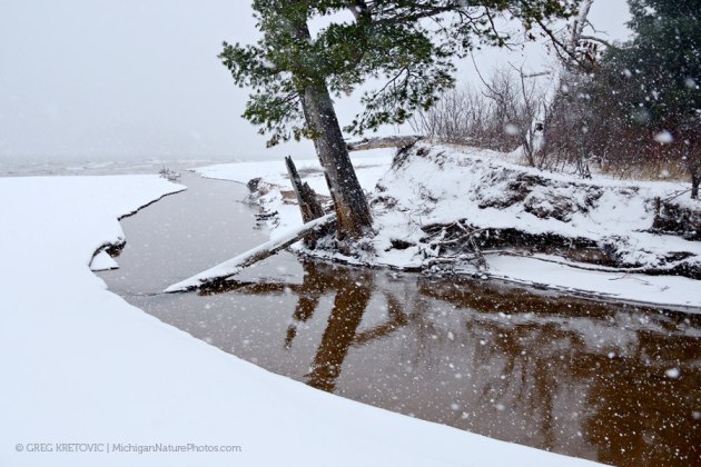
Marquette, MI
Thanks to Greg Kretovic for the picture below out of Marquette, MI during some recent lake effect snow.
The Big Ball Drop
New York City will be abuzz today/tonight with people looking for the best spot to ring in the new year. It'll be a little chilly, but festive with a chance of light snow around midnight.
Here's a look at all the events for New Year's from timessquarenyc.org HERE:

Festive Forecast
The forecast for the big event looks a bit cool, but also fairly festive! Look for a little light snow as countdown continues. Here's a look at the NYC forecast from the WeatherNation app available on Itunes.
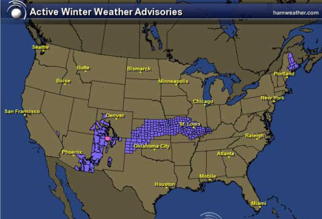
Shovelable Snow Event For Some
The next winter event will move across the mid-section of the nation today with shovelable snow potential for some. Winter Weather Advisories have been posted from the Texas Panhandle to the Ohio Valley with 2" to 4" possible and isolated 6" amounts possible as well.
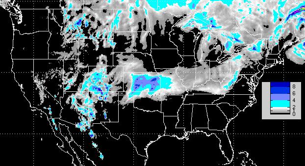
Snowfall Forecast
This is a look the RPM snowfall forecast through midday Wednesday, note the heavier tallies around central/eastern Kansas with up to around 6" possible in spots.
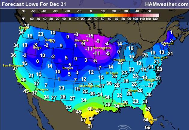
Cold Into the New Year
Here's a look at the forecast lows across the nation New Year's Eve... Brr!
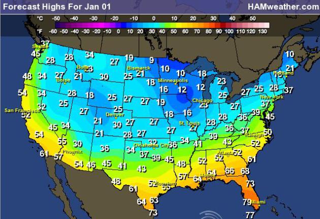
Cold Highs New Year's Day
It definitely looks cold into the New Year. Here are the forecast high temperatures for Tuesday, January 1st. Temperatures across the nation will be running several degrees below normal for many locations.
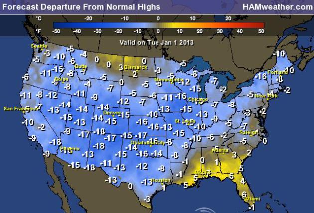
Highs From Normal on January 1st
Here are the highs from normal across the nation on Tuesday, note that most locations other than the southeast will be well below average temperatures for the first of the year.
Thanks for checking in and have a great rest of 2012 and New Year ahead!
Don't forget to follow me on Twitter @TNelsonWNTV

No comments:
Post a Comment