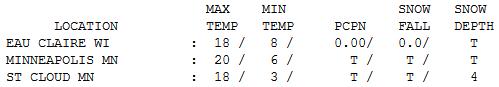
20 F. high on Thursday in the Twin Cities.
23 F. average high for January 17.
20 F. high on January 17, 2012.
Trace of flurries fell at KMSP yesterday.
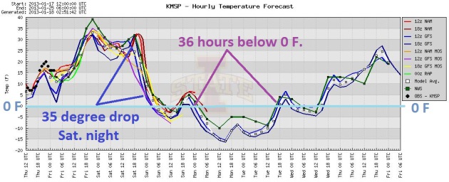
35-40 F. highs today and Saturday, then a 35 degree temperature drop Saturday night.
36 hours of subzero weather expected, from Sunday evening thru midday Tuesday, probably the coldest weather of the winter.
Boasting Rights
Not sure what to do. I'm tempted to drive to MSP
International, scan the departure screen and cash in some Delta
frequent flier miles. On the other hand, the (delightfully) insane voice
in my head is telling me to stay put. Tough it out. Embrace the burn.
Here's the deal: the Arctic Spanking setting up
for early next week doesn't look quite as forbidding as it did 2 days
ago. Highs hold just below zero Monday, but it won't be anything like
January, 2009, when we enjoyed 15 subzero nights (as cold as -21F) and 3
subzero days.
We're just not seeing the frequency &
intensity of polar air that was commonplace in the 70s and early 80s.
Many years Old Man Winter pulls his punch.
Although we're not tracking as warm as last
winter, based on heating degree data we've saved 9 percent on heating
bills since autumn in the Twin Cities. We've been so pampered most
winters that now "average" seems unreasonable.
We may hit 40 (above!) today, a Saturday thaw
gives way to cold, howling winds by Saturday night. Expect 36 hours of
negative numbers between Sunday evening and midday Tuesday; Monday
should be the coldest day, probably of the entire winter season.
By the way, just for the record, if we had a few
inches of "snow" on the ground (remember snow?) we'd be a good 10-15F
colder than we will be Sunday into Tuesday. Subzero with brown ground,
more evidence of a persistent drought, will be something of a
disconnect.
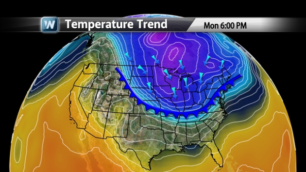
The Mother Lode. At least for this winter, coming
about 3-5 days after what is (historically) the coldest day of winter,
right around January 16 or so. By Monday at 6 pm subzero wind chills
will impact a large chunk of the USA, from the Rockies to the Great
Lakes and Ohio Valley, pushing into New England. Time to dig out your
heaviest winter coat.
Big Changes. Highs should reach the mid to upper 30s
today and Saturday, followed by a sharp drop in temperature Saturday
PM. At this point Monday may be the only day in sight where high
temperatures hold (just) below zero, a wind chill dipping to -20 to -25
at times. Temperatures rebound next week, the ECMWF printing out
accumulating snow next Thursday as temperatures thaw out a bit and a
storm tracks south/east of Minnesota. Too early for specifics.
A Fresh (Yukon) Breeze. Make the most of one more
January Thaw today into the first half of tomorrow. A 30-35 F.
temperature tumble is likely during the PM hours tomorrow, "highs" in
the low single digits Sunday, holding below zero Monday (for the first
time in about 4 years). I think we'll struggle above zero Tuesday
afternoon, after roughly 36 hours of subzero air temperatures. 20s will
feel like a dream by Thursday of next week. Really. Graph: Iowa State.
Recovery. No 50s showing up - not a hint of spring
fever in sight, but here in The Land of Low Weather Expectations we'll
be just fine with 20s and a few 30s the last week of January. We'll see
more cold fronts, but I suspect the outbreak shaping up for early next
week will be the coldest of winter, a winter I still expect to trend
(slightly) warmer than average, overall.
Snowfall This Winter, To Date:
1.1" Chicago
1.1" Philadelphia
1.7" Jackson, Mississippi
2.8" San Angelo, Texas
3.1" El Paso, Texas
"Wake-Up Call": Chicago Set To Break 73-Year-Old Snowless Record.
As bad as it is for snow-lovers in Minnesota, it could be worse. Much
worse. Chicago has seen just over 1" of snow so far this winter season,
which has a lot of people scratching their heads in wonder.
NBC News has more details: "
Chicago
residents have managed to avoid one winter chore almost altogether
this year: shoveling. The city perched on the shores of Lake Michigan,
ever braced for a harsh winter, is set to break a decades-old record
for lack of snow. On Wednesday, assuming forecasts hold, the city will
have its 320th day without an inch of snow, breaking a record set in the
winter of 1939-1940, according to Accuweather.
A dusting in Chicago on Sunday brought the snow total for the whole
winter to a meager 1.3 inches. "This is a wake-up call of how we may
have to adapt," said Brant Miller, chief meteorologist at NBC's Chicago affiliate, referring
to the process of climate change that contributes to the unusual
weather. "It’s not going to be business as usual going forward..." (photo credit above: AP).
Winters Aren't What They Used To Be. In today's segment of "
Climate Matters"
we take a look at a developing snow drought over northern tier states
(more snow in Jackson, Mississippi and El Paso, Texas than Chicago so
far this winter), and what is driving increasingly erratic winters: "
Meteorologist
Paul Douglas offers perspective on some of this season's winter
weather. Is the predicted arctic blast in the Midwest considered
unusual? Plus, the snow surprises this season."
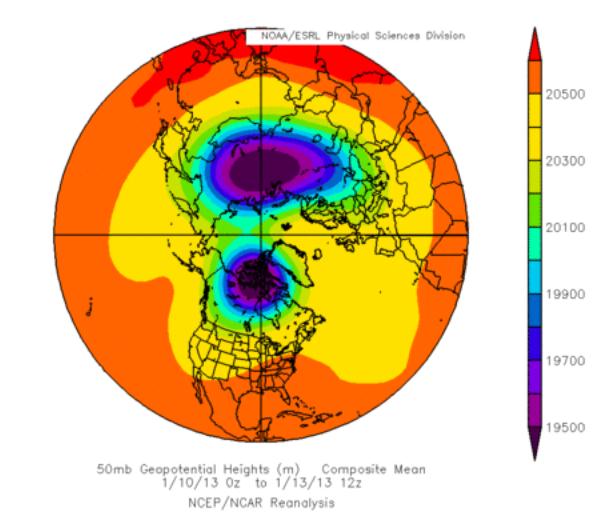
Sudden Stratospheric Warming Split The Polar Vortex In Two. Here's an article at
The Daily Kos
that caught my attention. Extreme storms are bearing down on Hawaii,
and much of Europe in the coming days - this sudden intensification may
have something to do with a sudden upward spike in temperatures in the
upper atmosphere. Here's an excerpt: "
Sudden stratospheric warming
has split the polar vortex in two. The polar vortex, which forms and
deepens as the atmosphere looses heat to space in the darkness of the
long Arctic winter night, was split in two by massive heating from
below. A series of intense storms in the far north Pacific intensified a
very long wave in the lower atmosphere. Energy on that planet sized
wave went upwards from the lower atmosphere around the Himalayas and
Tibetan Plateau and broke into the stratosphere, causing major sudden
warming. It rapidly reversed the strong cyclonic winds in the
stratosphere around the pole, creating a central dome, breaking the
vortex into two smaller vortices..."
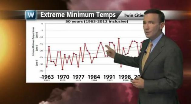
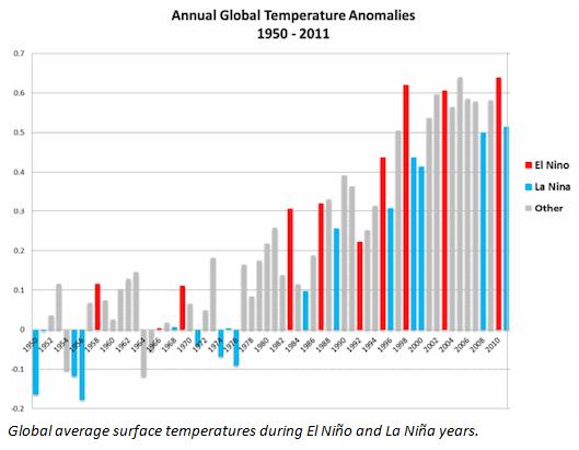
2012: 9th Warmest Year on Record. It was also the warmest La Nina year ever recorded, according to NOAA.
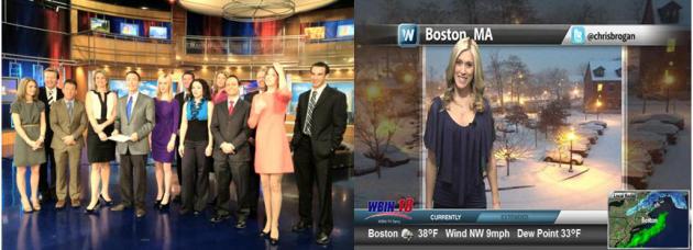
That's A Lot Of Meteorologists. We've teamed up with
KARE-11 to bring WeatherNation TV, our new 24/7 headline weather and
meteorology channel, to Minnesota. The service just launched in Boston,
other major markets to follow. Thanks to everyone who has tuned into
KARE-11.2, or tuned in on cable around the state. All weather - no
excuses.
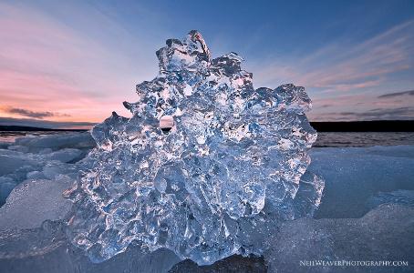
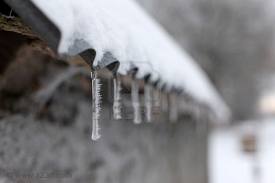
Wild Ice Formations. Thanks to Neil Weaver Photography and
WeatherNation TV
for sending in this photo, unlike anything I've ever seen before.
Weaver shot this pic on Lake Superior, from a vantagepoint on the U.P.
of Michigan.
How Can You "Vogue" Your Way Thru Hurricane Aftermath?
Tasteless..or edgy? You be the judge. For some inexplicable reason the
editors at Vogue felt the need to send their models into Sandy's debris.
Check out the slide show
here. More from
Huffington Post.
Jodie Foster's Guide To Life At 50 And Beyond. I found this to be an interesting post, courtesy of PBS's
nextavenue.org; here's an excertp: "...
It
should come as no surprise that what is good advice for those who are
50 and older is also good advice for those who are younger. Here’s my
interpretation of Foster’s guidance:
1. Don’t be afraid to claim your age; own it and the body that goes with it.
She started off her speech by announcing “I’m 50! I’m 50!,” setting
the stage for heartfelt resolutions about how to live life in the
second stage of adulthood. She had a light-hearted view of her age and
quipped, “You know, I was going to bring my walker tonight but it just
didn’t go with the cleavage.”
2. Be exceptionally grateful all the time, especially for those who are often unsung — and tell them often. We’re all used to award recipients ticking off a long-winded list of people we’ve never heard of who need to be thanked...."
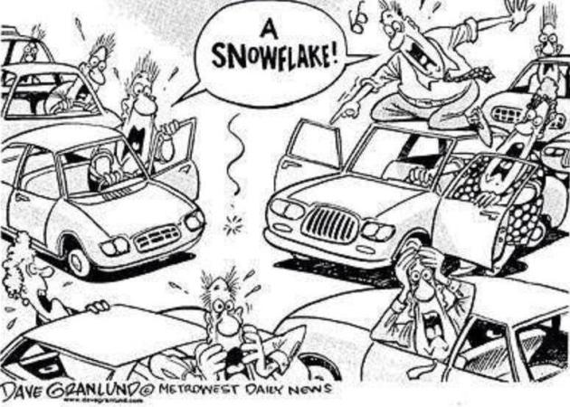
One Cartoon Sums It Up. Thanks to Dave Grandlund at
the Midwest Daily News for summing up, so eloquently, the perils of a
single snowflake. Looks like winter in Washington D.C., where the mere
mention of "flurries" can trigger a run on grocery stores. I'm not
exaggerating.
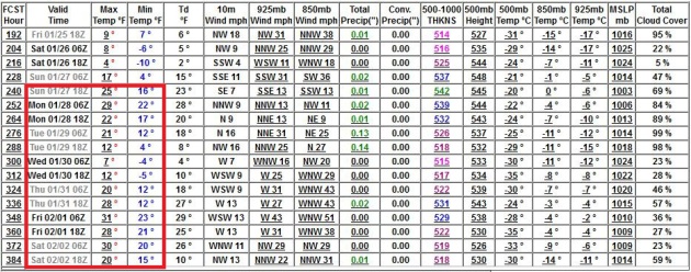
Implications Of Little Snow. All the models
suggested a high today around 16-18 F. It turns out the metro area saw
highs closer to 20. It turns out a lack of snow is decreasing albedo
(less white lurking out there - more brown), which allows the sun to
warm up the air near the ground a few extra degrees. After morning
flakes the sun came out, highs ranging from 15 at Alexandria to 18 St.
Cloud, 20 Twin Cities and 24 Redwood Falls.
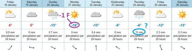
Paul's Conservation Minnesota Outlook for the Twin Cities and all of Minnesota:
TODAY: Light snow tapers, slick roads early. Another January Thaw. Pleasant. Winds: SW 15. High: 36-40
FRIDAY NIGHT: Clouds and patchy fog, relatively mild. Low: 30
SATURDAY: Mild start. Bitter winds late with flurries. High: 35, falling thru the 20s and teens late (winds gust 20-40 mph).
SATURDAY NIGHT: Bitter with highs winds and a wind chill of -20F. Low: -3
SUNDAY: Sunny start, PM coating of fluff. Bitter. High: 4
MONDAY: Yukon-like. Coldest day of winter. WC: -20. Wake-up: -9. High: -2
TUESDAY: Mostly cloudy, comfortably numb. Wake-up: -13. High: 5
WEDNESDAY: Fading sun, not quite as Nanook. Low: -1. High: 17
THURSDAY: Potential for accumulating light snow. Low: 15. High: 23
Climate Stories...
6 Ways Climate Change Will Affect You. This is a
slow-motion transformation, and yet we're seeing some of the impacts of a
warmer atmosphere (more extreme rainfall amounts, an uptick in weather
disasters, rising sea level, dry areas getting drier, the list goes on
and on).
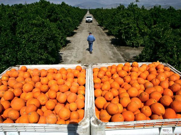
National Geographic does a good job summarizing why we should all be engaged on this subject; here's an excerpt: "
The planet keeps getting hotter, new data showed this week. Especially in America,
where 2012 was the warmest year ever recorded, by far. Every few
years, the U.S. federal government engages hundreds of experts to
assess the impacts of climate change, now and in the future. From
agriculture (pictured) to infrastructure to how humans consume energy,
the National Climate Assessment Development Advisory Committee spotlights
how a warming world may bring widespread disruption. Farmers will see
declines in some crops, while others will reap increased yields. Won't
more atmospheric carbon mean longer growing seasons? Not quite..."
Photo credit above: AP Photo/Marcio Jose Sanchez
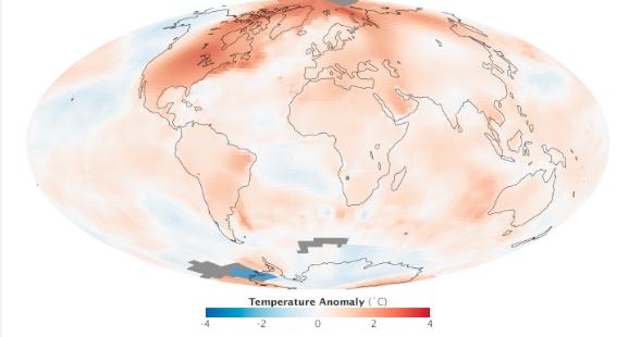
Long Term Global Warming Trend Continues. Here's the intro to a good summary of 2012 from
EarthSky.org: "
Scientists
report that 2012 was the ninth warmest year since 1880, continuing a
long-term trend of rising global temperatures. The ten warmest years in
the 132-year record have all occurred since 1998. The last year that
was cooler than average was 1976. This map, from NASA Earth Observatory,
depicts temperature anomalies, or changes, by region in 2012. Reds and
blues show how much warmer or cooler each area was in 2012 compared to
an averaged base period from 1951–1980..." (graphic above: NASA).
Earliest Blooms Recorded In U.S. Due To Global Warming. Here's an excerpt from
National Geographic: "
You could call them early bloomers: In 2010 and 2012, plants in the eastern U.S.
produced flowers earlier than at any point in recorded history, a new
study says. This result, according to the research team, has a bit of a
literary twist: It comes from data collected by U.S. environmental
writers Henry David Thoreau and Aldo Leopold. Thoreau began observing bloom times in Massachusetts in 1852, and Leopold began in Wisconsin
in 1935. Scientists compared this historical data with modern,
record-shattering high temperatures in Massachusetts and Wisconsin
during 2010 and 2012. (See "Heat Waves 'Almost Certainly' Due to Global Warming?")
They discovered that those two recent warm spells triggered many
spring-flowering plants to blossom up to 4.1 days earlier for every 1
degree Celsius rise in average spring temperatures, which translates to
2.3 days for every 1 degree Fahrenheit..."
Photo credit above: "
Forget-me-nots bloom during springtime (file picture)." Photograph by
Darlyne A. Murawski, National Geographic.
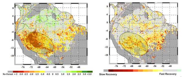
Study Finds Severe Climate Jeopardizing Amazon Forest.
NASA JPL has the story; here's an excerpt: "
At
left, the extent of the 2005 megadrought in the western Amazon
rainforests during the summer months of June, July and August as
measured by NASA satellites. The most impacted areas are shown in
shades of red and yellow. The circled area in the right panel shows the
extent of the forests that experienced slow recovery from the 2005
drought, with areas in red and yellow shades experiencing the slowest
recovery."
Image credit: NASA/JPL-Caltech/GSFC
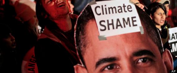
Obama On Climate Change Faces High Expectations, And High Hurdles, In Second Term. Here's a snippet from an article at
Huffington Post: "...
If
past is prologue, Obama is unlikely to make anyone fully satisfied.
While many conservatives spent much of the last four years condemning the president
as an environmental zealot bent on sacrificing jobs and economic
growth to the altar of green, Obama also took substantial heat from his
environmental base. A broad collection of conservation groups and
climate activists have argued that the president was walking an equivocal line at best, championing emissions reductions, for example, while also embracing expanded oil and gas drilling, including in the delicate Arctic, and continuing his support for so-called clean coal technology, which many environmentalists consider an oxymoron..." (Image above: AP).
Global Warming Opening Up Russia's Arctic Oil.
The UPI has the story; here's an excerpt: "
Russian
state-owned energy firms are preparing to move into the country's
offshore polar regions. On Jan. 15 Russian Deputy Prime Minister Arkady
Dvorkovich's told journalists that the state-controlled Rosneft and
Gazprom energy companies are to receive licenses to develop the 12 and
17 arctic continental shelf sectors. The decision is raising concerns
among the country's private energy companies that they will be locked
out of developing the country's potentially vast arctic hydrocarbon
reserves. Russia's natural resources ministry proposed on Jan. 15 that
offshore oil and gas fields on the country's Arctic shelf that isn't
wanted by state-controlled firms should be explored and developed by
non-state companies..."


No comments:
Post a Comment