36 F. high in the Twin Cities yesterday.
23 F. average high for January 16.
32 F. high on January 16, 2012.
.3" snow fell at KMSP yesterday.
Subzero weather likely from Sunday evening into midday Tuesday, possibly the coldest in 4 years.
-20 to -25 F. wind chills possible Monday.
30 F. highs return by Thursday of next week.
A (Brief) Siberian Swipe
7 of the 10 warmest years in recorded Minnesota
history have taken place since 1998. Last winter brought only 3 nights
below zero (the latest 30-year running average is 22.5 nights of subzero
fun every winter at MSP). The trends are undeniable.
But Earth is still tilted on its axis, nights
are still long over the Northern Hemisphere. Cold fronts will still
surge southward into the USA.
Saying that a couple of numbing days refute a
warming atmosphere is like judging Adrian Peterson from one play, and
not looking at his entire career as an NFL running back.
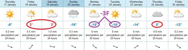
The rumor is true: 2 days with highs below zero
next Monday & Tuesday. We may wake up to -15F Tuesday morning. Air
temperature.
The coldest outbreak in 4 years. Increasingly
rare, but not unprecedented. And hardly the week after week of subzero
pain back in the 1970s.
Sunny teens today give rise to a thaw tomorrow. A
mild start Saturday, and then we fall over the temperature cliff
Saturday night; single digits by Sunday. We probably won't climb above
0F. from Sunday evening into early Wednesday.
We'll make the national news. Your Aunt Ethel will call to make sure you're OK. We'll get thru this, as winter "bottoms out".
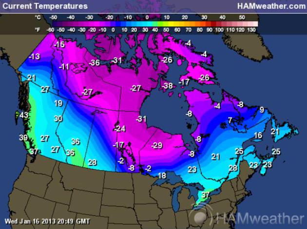
Wednesday "Highs". I grabbed this map from 3 pm
yesterday, showing the core of the Arctic air pushing slowly south
across Canada. We'll get to enjoy some of this fresh air from Sunday
into Wednesday morning of next week, probably the coldest spell of
winter. Map:
Ham Weather.
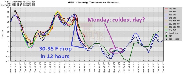
Thaw, Then Awe. Models show low to mid 30s Friday
and the first half of Saturday, followed by a 35 degree temperature drop
Saturday night; temperatures hovering just above 0 F. Sunday, then
dropping below zero from Sunday evening into at least Tuesday morning.
ECMWF keeps us (just) below zero on Tuesday as well, but we finally pull
out from under the worst of the chill by Tuesday night and Wednesday.
Two Days Of (Minor) Pain. We've seen worse, in fact
the outbreak in January, 2009 was probably colder/longer than what we'll
experience early next week. ECMWF guidance shows highs below zero
Monday and Tuesday, then recovering by the middle of next week, coming
close to freezing by Thursday of next week. A coating of snow is
possible Saturday and Sunday as the leading edge of polar air arrives.
You'll be shocked to hear no big storms are in sight.
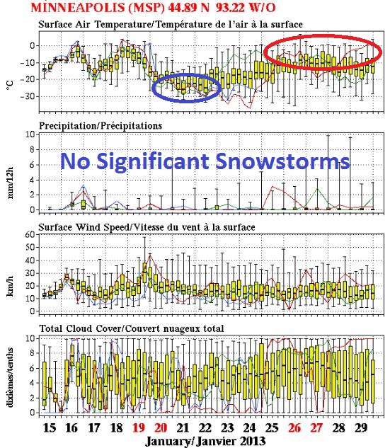
Next Week: Probably The Coldest Of Winter. Could we
see a similar subzero blast in February? Possible, but not terribly
likely. Historically our coldest day of the year is January 15-16; the
best chance of subzero cold often comes 3-4 weeks after the Winter
Solstice. The extended NAEFS trends (courtesy of Environment Canada)
show temperatures bottoming out early next week, then recovering into
the 20s and 30s the last week of January. No significant snow is in
sight thru the end of the month.
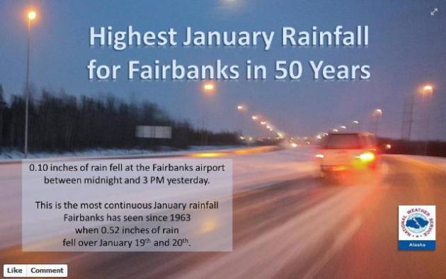
Rain In Fairbanks? When Alaska is unseasonably mild,
Minnesotans usually shiver. Such will be the case early next week. A
tenth of an inch of rain, in the dead of winter, in Fairbanks, Alaska,
is very unusual. Details from the Alaska office of the
National Weather Service: "
The
anomalous rainstorm that glazed interior roads yesterday, causing
school and business closures, produced the most rain Fairbanks has seen
from a single January storm in half a century."
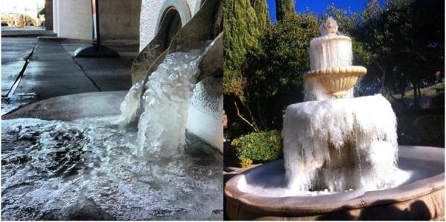
Vegas Freeze. While it rains in the interior of
Alaska, tourists and locals in Las Vegas are freezing their butts off.
The photo in the upper left is courtesy of Amy Jo Martin and
Instagram, the frozen fountain pic in the upper right was snapped by
nickcrsvr. Thanks to both of our weather contributors today - sorry about the untimely cold front.
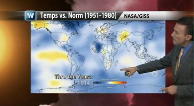
Top 10 Global Weather/Climate Events of 2012. Here is
NOAA NCDC's list of top events; frankly I was surprised by what they picked as the #1 event of last year. Sandy was third on the list: "
Meteorologist
Paul Douglas takes a close look at a NASA animation showing global
temperature trends over the last 100 years. Plus, the National Climatic
Data Center (NCDC) ranks the Top 10 Global Weather/Climate Events of
2012, with input from both weather and climate experts. See what topped
the list."
A Real Snowbird. O.K. Like most Minnesotans, I plan
on weathering next week's Arctic front first-hand. I'm tempted to
evacuate for a warmer climate, but part of me (the insane part) wants to
experience this first-hand. Thanks to Jeff Edmonson for this photo of a
pint-size bird at Twin Cities International Wednesday. Hoping to catch a
southbound flight along with everyone else?
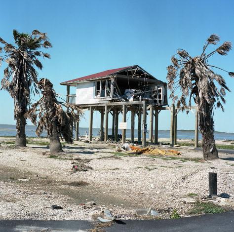
The Long Tail Of A Hurricane. Here's an excerpt of an excellent story at NPR: "
The House just approved
a $50 billion assistance package to victims of Hurricane Sandy —
months after the storm wrecked much of the East Coast — although the
Senate is yet to vote. Securing relief funds after natural disasters
has traditionally been noncontroversial, but with the recent deficit
debates, this has been an unusual struggle. And sometimes, funding
doesn't seem to be enough. Take Galveston, Texas, for example. In 2008,
the city was rocked by Hurricane Ike. And when Sandy Carson went to
photograph it a few years later, what he found was a city, in many
ways, still in shambles..."
Photo credit: Sandy Carson.
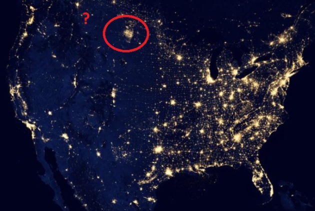
A Mysterious Patch Of Light Shows Up In The North Dakota Dark.
Notice the smudge of light in North Dakota? No, those aren't the lights
of Bismarck, but a very visual symptom of the scale of fracking going
on just to our west. Robert Krulwich has a story at
NPR; here's an excerpt: "...
What
we have here is an immense and startlingly new oil and gas field —
nighttime evidence of an oil boom created by a technology called
fracking. Those lights are rigs, hundreds of them, lit at night, or
fiery flares of natural gas. One hundred fifty oil companies, big ones,
little ones, wildcatters, have flooded this region, drilling up to
eight new wells every day on what is called the Bakken formation.
Altogether, they are now producing 660,000 barrels a day, double the
output two years ago, so that in no time at all, North Dakota is now
the second largest oil producing state in America. Only Texas produces
more, and those lights are a sign that this region is now on fire ...
to a disturbing degree — literally..."
Image courtesy of
ihasahotdog.com.
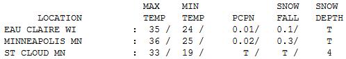
Welcome Thaw. It felt pretty good out there thru
midday, with highs in the 30s statewide. Highs ranged from 33 at St.
Cloud to 36 in the Twin Cities (37 at Eden Prairie and St. Paul).
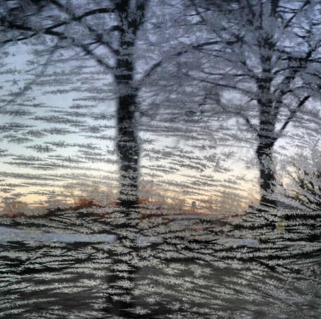
Frosted Glass. Thanks to Imara Hixon (and
Instagram) for this wintry photo taken in Golden Valley.
Paul's Conservation Minnesota Outlook for the Twin Cities and all of Minnesota:
TODAY: Partly sunny and colder. Winds: W 8-13. Wake-up: 2. High: 18
THURSDAY NIGHT: Clouds, a few flurries, rising temperatures.
FRIDAY: Mostly cloudy, welcome thaw. High: 34
SATURDAY: Mild start, turning
sharply colder late. Coating of flurries expected. Winds: NW 15-30 (by
late afternoon). Wake-up: 22. High: 33, falling thru the 20s by
afternoon.
SUNDAY: Bitter. Snowy coating-2" possible late. Wind chill: -15 F. Wake-up: 0. High: 3
MONDAY: Coldest day. Bitter sun. Wind chill: -25 F. Wake-up: -8. High: -4
TUESDAY: Character-building. Still numb with intervals of sun. Wake-up: -14. HIgh: -1
WEDNESDAY: Worst is over. Temperatures rise. Low: -7. High: 10
* Low 30s (above zero!) return by Thursday of next week. Deep breaths.
Climate Stories...
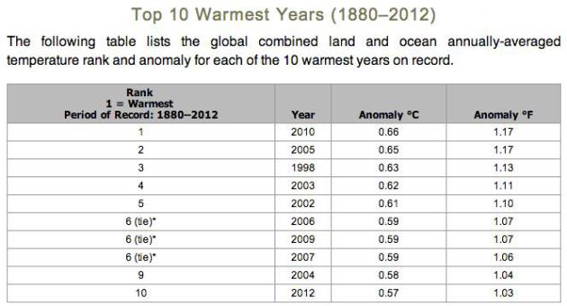
Top 10 Warmest Years Worldwide. All 10 of the
warmest years ever measured, worldwide, have occurred since 1998. We've
gone 36 consecutive years with global temperatures warmer than the 20th
century average, according to NOAA.
Black Carbon Ranks As Second-Biggest Human Cause Of Global Warming.
The Washington Post has the story; here's an excerpt: "
Soot ranks as the second-largest human contributor to climate change, exerting twice as much of an impact as previously thought, according to an analysis released Tuesday. The four-year, 232-page study of black carbon,
published in the Journal of Geophysical Research: Atmospheres, shows
that short-lived pollution known as soot, such as emissions from diesel
engines and wood-fired stoves, has about two-thirds the climate impact
of carbon dioxide. The analysis has pushed methane, which comes from
landfills and other forces, into third place as a human contributor to
global warming..."
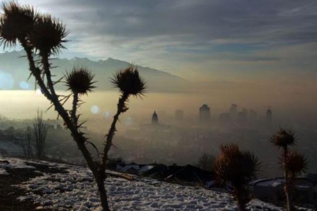
Photo credit above: "
Smog and haze hover over Salt Lake
City. The thick layer of smog lingering over Utah has fouled the
state's mountain air so badly that health officials have warned people
not to exercise outside and schools are keeping children inside for
recess and sports. The smog is blamed on a weather phenomenon that pins
pollution to the valley floors.
" Brian Nicholson / AP
Burning Fuel Particles Do More Damage To Climate Than Thought, Study Says.
The New York Times has more details on new research showing the risks posed by black carbon; here's a snippet of a recent article: "...
Although
some scientists have long believed that black carbon is a major force
in climate change, the vast majority of previous mathematical models
had predicted that the particles had only a modest impact. That view
should now change, said Mark Z. Jacobson, an atmospheric scientist at
Stanford University and one of the study’s authors, calling the old
models “overly simplistic.” He said that many of his co-authors had
previously hewed to the lower estimates. Veerabhadran Ramanathan, a professor of climate science at the Scripps Institution of Oceanography
in San Diego who has long campaigned to control black carbon,
described the study as highly authoritative. “The fact that it’s
written by a very large group of modelers gives it enormous
credibility,” he said. “It was lonely before. I’m now glad to be right
in the middle...”
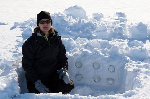
File Photo credit above: "
Patricia Quinn, a research
chemist at NOAA's Pacific Marine Environmental Laboratory in Seattle,
stands in a snow pit at a scientific research area on an island in the
Svlabard islands in Arctic Norway. Quinn lead a team of Seattle
scientists who studied the role of the black carbon, or soot, in the
changing Arctic climate."(Courtesy NOAA/MCT)
Climate Change Series: Where Science And Ethics Meet. Here's an excerpt of a
WBUR article that resonated with me: “
Global
warming,” which sounds gradual and reversible, does not begin to
describe the challenge we face today. The obstacle ahead is unstable
and irreversible – it is climate change. “Unstable” because the warming
of the earth’s atmosphere can set up feedback loops that dramatically
change the earth’s fundamental climate patterns. “Irreversible” because
once these changes take place, we know of no way to undo them and
return to the climate patterns that have existed throughout human
civilization...."
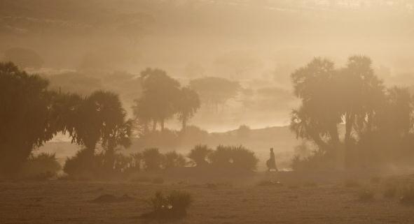
Photo credit above: "
In this Nov. 2, 2012 photo, a woman
walks toward a well through clouds of dust raised by cattle in the Mao
region of Chad. For generations, the people of this bone-dry region
lived off their herds, but climate change has meant that the normally
once-a-decade droughts are now coming every few years." (Rebecca Blackwell/AP)


No comments:
Post a Comment