23 F. average high on January 15.
40 F. high on January 15, 2012.
1" snow so far in January in the Twin Cities.
Subzero weather likely from Sunday evening into Wednesday morning of next week; probably the coldest of winter.
Couple inches of powdery snow possible Sunday; roads may be very icy.

Outlook: a Little Pain
Is this your first Minnesota winter? You arrived with a light jacket and a confident smirk? "How bad can it be - bring it on!"
(Insert sinister laughter-track here.)
Old Man Winter is about to rock your world; 2-3
days worth of world-rocking, to be precise. A burst of Siberian air will
keep daytime "highs" below zero next Monday & Tuesday. Lows may
reach -15 F. in the metro, maybe -35F up north.
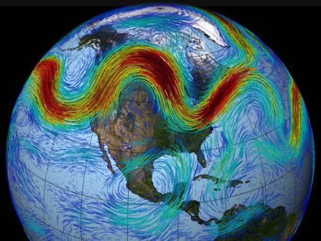
Why the big difference from last winter? A year
ago jet stream winds blew from the Pacific, consistently, keeping the
coldest air of winter bottled up over northern Canada. This year winds
aloft are light & erratic, allowing polar air to surge south. A lack
of significant snow on the ground will temper the chill (slightly), but
by Monday there will be NO doubt in your mind that you live in one of
the coldest major metro areas on Earth.
The atmosphere is warming worldwide, but every
now and then our weather will take a turn for the Nanook. In fact last
year's record melting of Arctic ice may be influencing the configuration
of the jet stream, something called "polar amplification", nudging
bitter air farther south.
A thaw is expected today & Friday, maybe 1-2 inches of snow Sunday as brutal air arrives.
BTW, we haven't seen a subzero high at MSP in 1,462 days.
* photo above: AP.
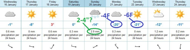
Arctic Smack.
Nothing subtle about the cold front shaping up for Sunday, marking the
leading edge of what will probably be the coldest air of winter. With an
air temperature from 0 to 6 F. Sunday snow ratios may be close to 40 to
1, meaning that 2.9 mm. of forecast precipitation may equate into 2-4"
of very light, fluffy, powdery snow - capable of blowing and drifting.
Roads may be VERY icy Sunday as the coldest air drills south. ECMWF data
predicts a high of -4 F. on Monday, -6 F. on Tuesday - some recovery in
temperature likely by the latter half of next week. Yes, this too shall
pass.
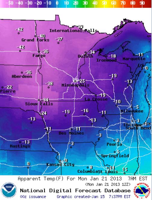
Ouch. The NOAA map
above shows the predicted wind chill at 7 am next Monday, ranging from
-25 F. in the Twin Cities to -38 F. at Windom, -34 F. at Duluth and -40
F. Seriously cold. This looks like the Mother Lode of cold air, in all
probability the coldest air of the winter. I pray.
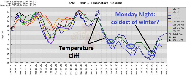
The Temperature Cliff.
After moderate temperatures today, again Friday and the first half of
Saturday, temperature drop like a (Siberian) rock Saturday afternoon and
night, holding in single digits Sunday (with some snow) before dipping
below zero from Sunday evening into midday Wednesday. This should be the
coldest outbreak in 4 years. Graph: Iowa State.
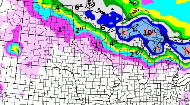

Family Of (Increasingly Cold) Alberta Clippers.
A coating of light snow is possible today (best chance early this
morning). The best chance of accumulating snow: Sunday, as the leading
edge of subzero air cascades south. Duluth may pick up as much as 6" of
snow; the GFS model above is only printing out an inch Sunday in the metro area, but I suspect amounts may be considerably higher: a light, fluffy, powdery snow, maybe enough to shovel Sunday.
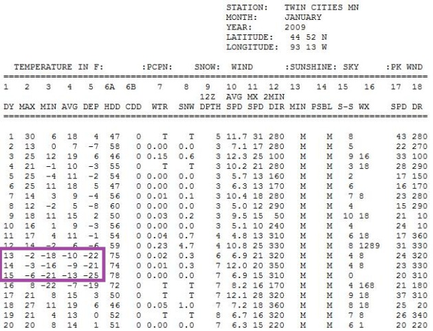
Last Subzero Highs In The Twin Cities?
You have to go back to January 15, 2009, to enjoy (?) a subzero daytime
high in the metro area (-6F, after waking up to -21F). That's 1,462
days ago. My hunch: we'll see 2, possibly 3 days below zero early next
week, rivaling the cold spell of January, 2009. Map above courtesy of
the Minnesota Climatology Working Group.
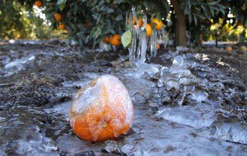
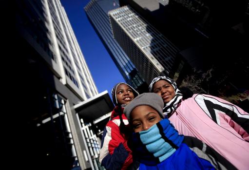
Photo credit above: "Anthony (in blue), Damarionna (pink) and Anthony Brown all wait for the bus to go home. All wore hats because it was only 12 degrees above zero in Minneapolis, MN on January 14, 2013." Source: Star Tribune.
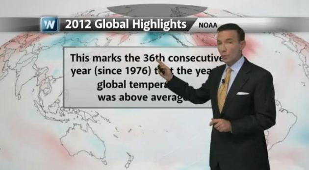
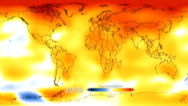
Global Warming Shown In NASA Computer Model. ABC News has a good time-lapse animation showing warming since the late 1800s; according to NASA 2012 was the 9th warmest year, worldwide. Yes, there is a slight discrepency with NOAA, which has 2012 as the 10th warmest.
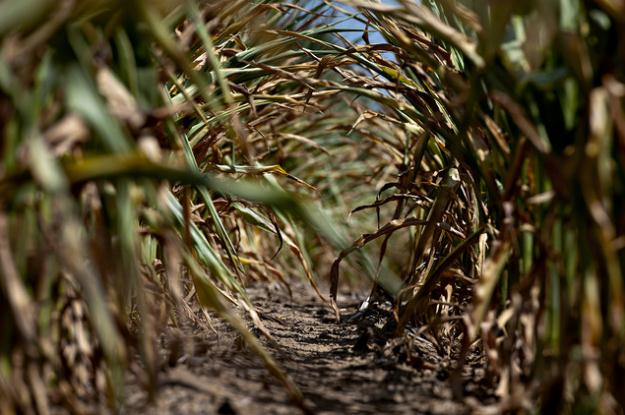
Photo credit above: "Dried corn plants in Idaville, Indiana." Photographer: Daniel Acker/Bloomberg
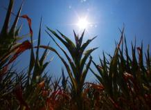
Drought-Tolerant Corn Advances Beginning To Show. With the specter of drought lingering into 2013 the timing couldn't be better; here's an excerpt of a story at The High Plains/Midwest Ag Journal: "There's nothing like a couple years of drought to help determine the advances being made in drought-tolerant corn. And Qingwu Xue, Ph.D., a Texas A&M AgriLife Research scientist, says there are some significant differences starting to show up. Xue, AgriLife Research crop stress physiologist in Amarillo, said drought and water issues have been very relevant in the last two years, especially the historic drought for Texas in 2011 and for the Corn Belt in 2012. Some of the drought-tolerant corn hybrids introduced since 2011 include: AquaMax by Pioneer, AgriSure Artesian by Syngenta and DroughtGard by Monsanto. "The question is, how have these drought-tolerant hybrids performed in our environment in the Texas Panhandle?" Xue said..." (Photo: madison.com).
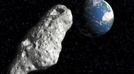
Image credit above: "An asteroid passing close to Earth next month will provide stargazers with a rare viewing opportunity." (Image: Shutterstock)

Image credit above: "Sony's prototype 56-inch OLED TV boasts 4K (3,840 x 2,160) resolution."
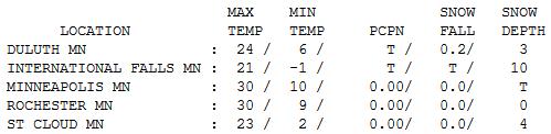
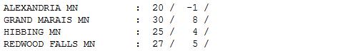
Grilling Weather. I hope you enjoy the current warm front, because 30s will seem unimaginable by early next week. Tuesday highs ranged from 21 at International Falls (10" snow on the ground) to 23 St. Coud (4" of snow) to 24 at Duluth (only 3" snow on the ground) to 30 in the Twin Cities, Rochester and Grand Marais.
Paul's Conservation Minnesota Outlook for the Twin Cities and all of Minnesota:
TODAY: Alberta Clipper: coating - 1/2" snow possible. Mainly wet roads. Winds: W 10-15. High: 32
WEDNESDAY NIGHT: Flurries taper, turning windy and colder. Low: 4
THURSDAY: At least the sun's out. Colder. High: 19
FRIDAY: Patchy clouds, welcome thaw. Wake-up temperature: 14. High: 34
SATURDAY: Turning windy & colder. Wake-up temperature: 13. High: 22 (falling by afternoon).
SUNDAY: Snowy clipper. Bitter winds. Couple inches of powdery snow? Wake-up temperature: 2. High: 7 (windchill dipping to -15)
MONDAY: Sunny and Arctic. Coldest in 4 years. Feels like -25F Low: -9. High: -4
TUESDAY: Yukon breeze, probably the coldest day of winter. Still bitter. Fading sun. Wake-up temperature: -14. High: -5
Climate Stories...
"It is difficult to get a man to understand something when his salary depends upon his not understanding it."
- Upton Sinclair
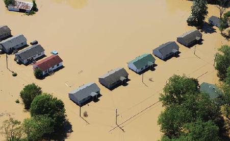
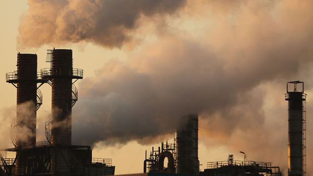
"...The draft Third National Climate Assessment, issued every four years, delivers a bracing picture of environmental changes and natural disasters that mounting scientific evidence indicates is fostered by climate change: heavier rains in the Northeast, Midwest and Plains that have overwhelmed storm drains and led to flooding and erosion; sea level rise that has battered coastal communities; drought that has turned much of the West into a tinderbox. "Climate change, once considered an issue for a distant future, has moved firmly into the present," the report says. "Americans are noticing changes all around them. Summers are longer and hotter, and periods of extreme heat last longer than any living American has ever experienced. Winters are generally shorter and warmer." - from a draft of the Third National Climate Assessment, as reported in the L.A. Times. (Photo: David Fine, FEMA).
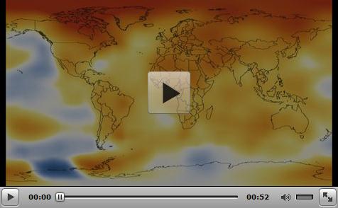
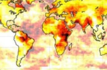
Graphic credit above: "NASA's analysis of Earth's surface temperature found that 2012 ranked as the ninth-warmest year since 1880. NASA scientists at the Goddard Institute for Space Studies (GISS) compare the average global temperature each year to the average from 1951 to 1980. This 30-year period provides a baseline from which to measure the warming Earth has experienced due to increasing atmospheric levels of heat-trapping greenhouse gases. While 2012 was the ninth-warmest year on record, all 10 of the warmest years in the GISS analysis have occurred since 1998, continuing a trend of temperatures well above the mid-20th century average. The record dates back to 1880 because that is when there were enough meteorological stations around the world to provide global temperature data."
Data source: NASA Goddard Institute for Space Studies
Visualization credit: NASA Goddard's Scientific Visualization Studio
Download this video and related materials in HD formats
Federal Forecast For Climate Change: It's Getting Hot In Here. Time Magazine takes a look at the latest National Climate Assessment, and how we've gone from climate change theory to reality. Americans are seeing the consequences of a warming atmosphere. Here's an excerpt: "...But the warming and weather disruption we’ve seen so far will just be the beginning. Late last week a team of more than 300 federal scientists released a draft of the National Climate Assessment, which gathers the latest research on how climate change is likely to affect the U.S. The semi-regular report — the third such published — is a product of the Global Change Research Act of 1990, which required a national climate assessment to be conducted every four years. This is the point at which you’re probably wondering why, if a 1990 law mandated that a national climate assessment be produced every four years, we’re only getting around to releasing the third one in 2013, or 23 years after the original legislation was passed. That’s in part because of the usual slow workings of the federal bureaucracy — complicated by the fact that the report is complied by an inter-governmental body involving 13 separate federal agencies and departments — but also because conservatives have repeatedly attacked the assessment for supposedly exaggerating the effects of climate change..."
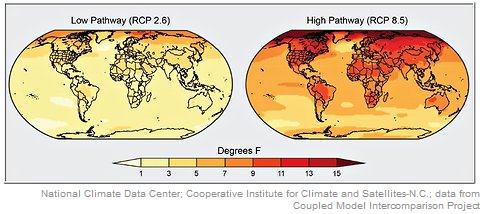
Image credit above: "Left, the projected change in annual average temperatures in 2071 to 2099 (compared with 1971 to 2000) if rapid reductions in emissions are achieved; right, the projected change if increases in emissions continue."

Obama Faces Dilemma On "Mother Of All" Climate Change Regulations. Will President Obama make good on a pledge to finally get serious about climate change, or will he kick the can down the road? Having the EPA shut down the dirtiest greenhouse gas sources (coal-fired power plants, older oil refineries) would be a good start, but there is huge political calculus involved. Here's an excerpt of a thought-provoking story from The National Journal: "On the night he won reelection, President Obama told a cheering crowd, “We want our children to live in an America that isn’t … threatened by the destructive power of a warming planet.” He has since said that climate change will be one of the top three priorities of his second term. This week, Obama heard a wailing siren warning him to stick to his pledge: On Monday, the National Oceanic and Atmospheric Administration reported that 2012 was by far the hottest year on record in the contiguous U.S. It was also the nation’s second-most-extreme year for destructive weather events, with 11 disasters sustaining $1 billion each in economic losses. On Friday, a new draft report by 13 U.S. federal agencies concluded that rising temperatures caused by fossil fuel emissions have directly contributed to increased wildfires, the spread of insect-transmitted disease, rising sea levels, melting glaciers and decreasing water supply across the U.S. Scientists said the evidence is unequivocal that the heat and catastrophic weather are linked to climate change caused by fossil-fuel pollution—and that without governmental action to stop that pollution, worse destruction is on the way..."
No comments:
Post a Comment