24 F. high temperature Sunday in the Twin Cities.
23 F. average high for January 6.
46 F. high on January 6, 2012.
1" snow so far in January.
3" snow on the ground at KMSP.
Feeling Less "SAD"
The dark days of winter can throw many of us
into a soul-sucking funk. A lack of sunlight can trigger anxiety, even
depression. Seasonal Affective Disorder is a medical reality for as many
as 1 in 10 Minnesotans. Taking melatonin supplements and sitting in
front of full spectrum light bulbs (that mimic the sun) can help. So can
a good travel agent.
"The best thing I did was order a new car with a
sunroof!" said meteorologist Katie Ferrier, one of a dozen weather
pros I have the pleasure of working with.
Katie reminded me of the benefits of snow and
"albedo" - more light reflected by 3 inches of crusty snow on the
ground. It's brighter out there now than it was back in snow-less
November, the cloudiest month of the year on average. That, and we've
picked up a 11 entire minutes of daylight since Dec. 21. Expect another
48 minutes of daylight by Jan. 31.
Our January Thaw is still on track; highs at or
above freezing into Friday. Light rain or drizzle (?) late Thursday
gives way to a burst of snow Saturday as colder air muscles into the
state.
Enjoy our midwinter siesta, because the coldest air of winter arrives the 3rd week of January; maybe a few days of pain.
I'm getting junk mail with swimsuit ads. And hey, the Minneapolis Boat Show is only 18 days away!
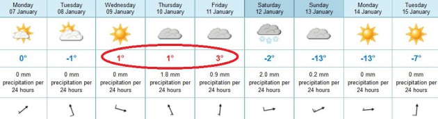
A Welcome January Thaw. Temperatures should come
close to freezing in the Twin Cities metro area, for the first time
since December 19. A clipper cools us off a few degrees Tuesday, and
then we warm up again Wednesday into Friday, probably 3 days in a row
with highs just above 32 F.
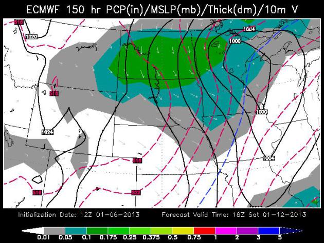
Fleeting Saturday Snow "Burst"? The European ECMWF
model, courtesy of WSI, shows a brief period of light snow Saturday, as
colder air plows southward into the state, maybe a quick inch or two.
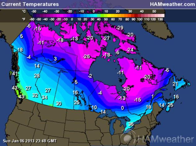
Preview Of Coming Attractions.
Here are Sunday evening air temperatures over Canada, readings in the
minus teens and minus twenties over northern provinces. This airmass
will modify (slightly) as it oozes south and east over the next 1-2
weeks, but I'm expecting the coldest air of winter between January 17
and 25, give or take - even a potential for a few record lows. Map
courtesy of
Ham Weather.
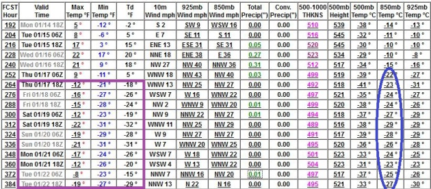
How Do You Say OUCH in Minnesotan? The models have
been flip-flopping - not every GFS run is this cold, but the trend lines
seem pretty clear. After enjoying a relatively mild week this week the
bottom drops out of your backyard thermometer by the third week of
January; what I suspect will be the coldest air of winter after January
17 or so. We may see a week of subzero lows, maybe 2-3 days of subzero
highs. Too early to say with confidence, but yes, it's going to get
seriously cold.
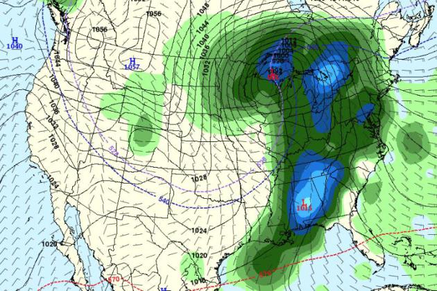
Hints of a White-Out. The arrival of (frigid) air
around the 17th may be preceded by a major storm over the Upper Midwest
and Great Lakes, some of the long-range guidance hinting at a plowable
snowfall by the middle of next week. Again, it's too early to offer
specifics - something we're watching carefully at this point. But keep
in mind that most outbreaks of bitter air are preceded by significant
snow. Most.
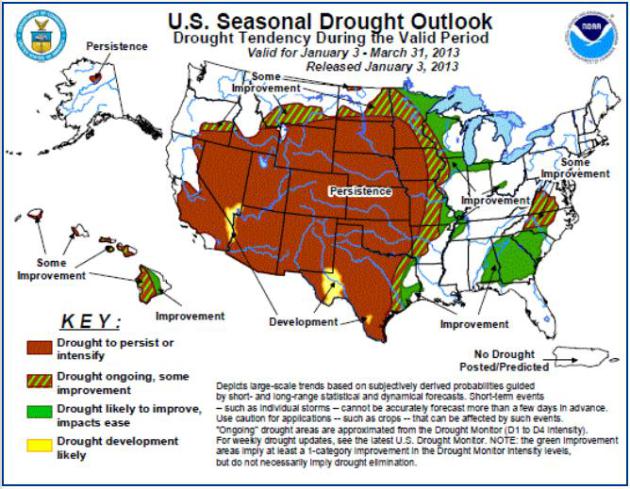
Drought Prediction. Here is
NOAA's drought forecast
into late March, showing "persistence" - or no real improvement from
southwestern Minnesota south to Texas and west to California. Some
improvement is possible from the Red River Valley to St. Cloud and the
Twin Cities, as well as southeastern Minnesota. We'll see.
Panorama. Here's the latest pic from one of my favorite (and prolific) photographers,
Mike Hall - snapped near Lewisport, Kentucky over the weekend.
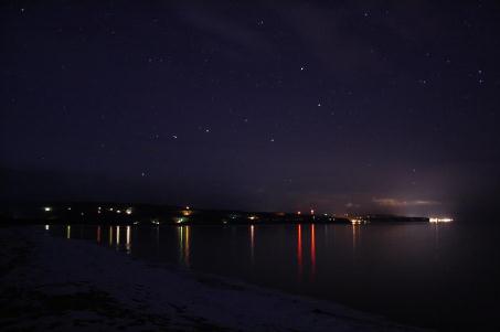
Big Dipper. Another weather enthusiast (and very
capable photographer) is Migizi Gichigumi, another regular contributor,
who snapped this photo of the Big Dipper near his home in Bayfield,
Wisconsin.
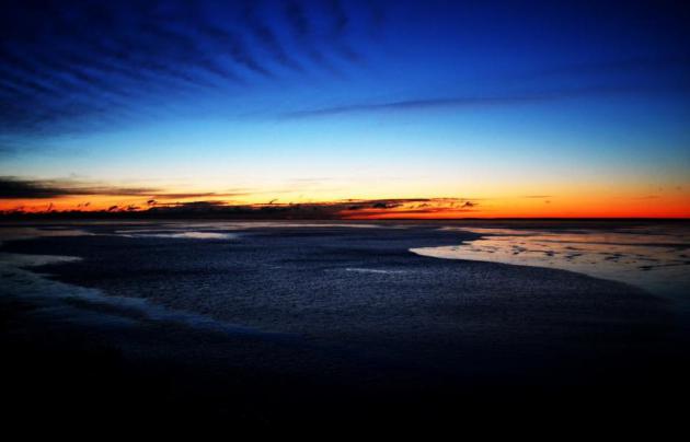
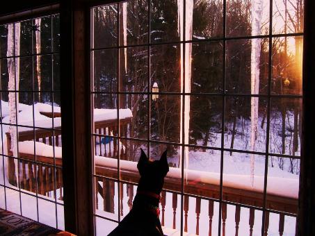
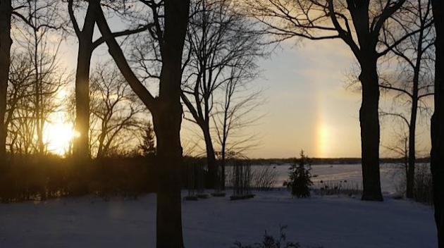
Curious Pooch. Yes, dogs are curious about the
weather too. Thanks to Rose Moore, who snapped this sunset photo at her
home in northeastern Ohio, courtesy of WeatherNation TV.
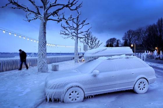
"Can I Borrow An Ice Scraper?"
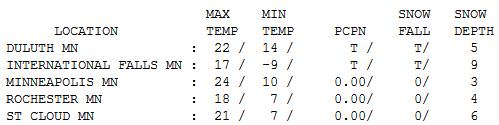
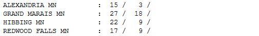
A Typical January Day. In spite of a stinging
breeze - temperatures Sunday were pretty close to normal for January 6;
afternoon highs ranging from 15 at Alexandria to 21 St. Cloud, 24 in
the Twin Cities and 27 at Grand Marais.
Paul's Conservation Minnesota Outlook for the Twin Cities and all of Minnesota:
TODAY: Partly sunny, slushy on the side streets by afternoon. Winds: SW 15. High: 33
MONDAY NIGHT: Partly cloudy, not as chilly. Low: 21
TUESDAY: Clouds increase, flakes up north from a weak clipper. High: near 30
WEDNESDAY: Plenty of sun, not bad for January. Low: 22. High: 33
THURSDAY: Clouds thicken, late drizzle or every light rain. Low: 24. High: 33
FRIDAY: Mostly cloudy, last "mild" day for some time. Low: 26. High: 35
SATURDAY: Burst of light snow, turning colder. Low: 22. High: 28
SUNDAY: Cloudy with a cold wind. Low: 8. High: 13
Climate Stories...
"A man should look for what is, and not for what he thinks should be." - Albert Einstein
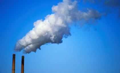
Pulling Carbon Dioxide Out Of Thin Air. Can
technology mitigate some of the mess we're in, even remove CO2 from the
atmosphere? Here's an excerpt of an interesting article at
The New York Times: "...
Now
a Canadian company has developed a cleansing technology that may one
day capture and remove some of this heat-trapping gas directly from the
sky. And it is even possible that the gas could then be sold for
industrial use. Carbon Engineering,
formed in 2009 with $3.5 million from Bill Gates and others, created
prototypes for parts of its cleanup system in 2011 and 2012 at its
plant in Calgary, Alberta. The company, which recently closed a $3
million second round of financing, plans to build a complete pilot
plant by the end of 2014 for capturing carbon dioxide from the
atmosphere, said David Keith, its president and a Harvard professor
who has long been interested in climate issues..."
Nature: Limiting Climate Change Will Become Much Harder "And More Expensive If Not Taken Soon". Here's a clip from a story at
Think Progress: "
Limiting
climate change to target levels will become much more difficult to
achieve, and more expensive, if action is not taken soon, according to a
new analysis from IIASA, ETH Zurich, and NCAR. The new study,
published this week in the journal Nature, examined the probability of
keeping average global temperatures from rising more than 2°C above
preindustrial levels under varying levels of climate policy stringency,
and thus mitigation costs. In addition, the study for the first time
quantified and ranked the uncertainties associated with efforts to
mitigate climate change, including questions about the climate itself,
uncertainties related to future technologies and energy demand, and
political uncertainties as to when action will be taken..."

No comments:
Post a Comment