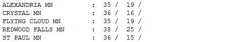
18 days/row with temperatures below freezing at MSP (December 19 to January 6).
36 F. high in the Twin Cities Monday, the first day at or above freezing since December 19.
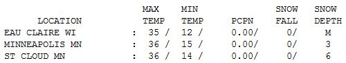
23 F. average high on January 7.
37 F. high on January 7, 2012.
Coating of snow possible Saturday (about as exciting as it gets looking out 2 weeks).
-10 F. wind chills possible in the metro area by Sunday.
Big Swings
The rumors are true: we may pick up a third of
an inch of rain on Thursday; coming 5 days before what is (historically)
the coldest day of the year. Mark Seeley reports a 4X increase in
midwinter rain and ice across Minnesota since 2000. Yes, this seems to
be a trend.
Soak up the relative warmth: 4 more days above freezing this week; 40 F. possible by Thursday and Friday.
Our 3 inches of snow on the ground may shrivel
to a dirty inch by late week. We are still marooned in an amazingly
persistent (snow) drought.
Take advantage of this week's break from wind
chill, because the coldest air of winter bullies its way into Minnesota
in 1-2 weeks. Models are flip-flopping on how cold (and how long) but
2-4 days of subzero fun seems imminent, starting late next week.
In spite of a rising sun angle; temperatures don't start to budge much until late January and early February.
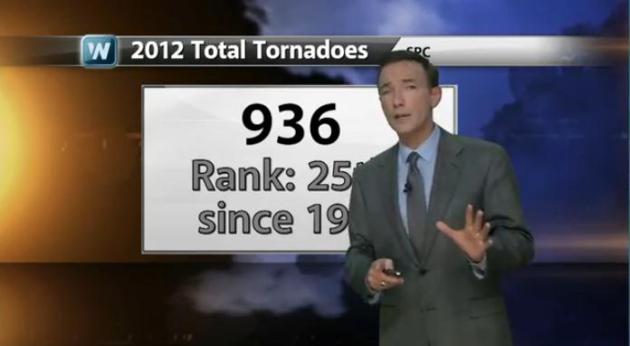
Today's blog includes a record heatwave for
Australia; snow on the ground over 66 percent of the USA; and only 936
tornadoes in 2012 - a result of stubborn heat and drought.
For now, dig out your second-string
(slush-proof) shoes and help me welcome an odd meteorological hiccup of
warmth - the January Thaw!
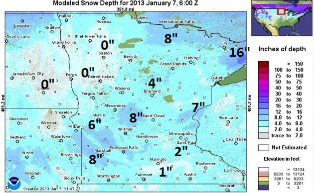
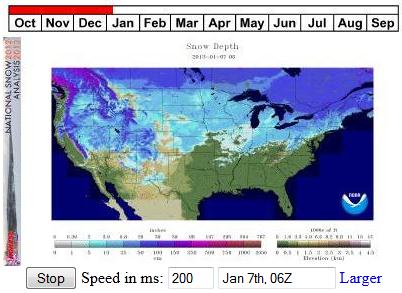
Where's The Snow? NOAA's latest
modeled snowcover map
shows some 4-9" amounts from near Sandstone and Taylors Falls to Sauk
Rapids, Benson, Marshall and Granite Falls, but I was struck by how
little snow there is on the ground over the Red River Valley and eastern
North Dakota.
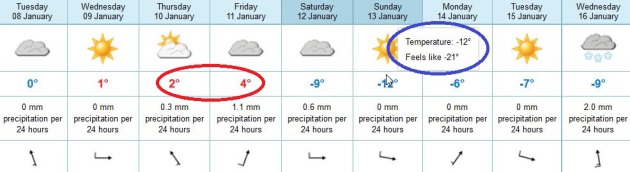
Mildest Week Of January? Yes, I have a hunch this is
about as good as it's going to get until the very end of January or
early February - 5 days in a row with daytime highs above freezing,
maybe mid to upper 30s by Friday. By Sunday highs will be stuck in the
low teens with a wind chill ranging from -5 to -10 F, based on ECMWF
data.
A Hiccup of Pacific Air. This relatively mild spell
is coming as a relief to most (but not all) Minnesotans, a chance to
thaw out for a few afternoons, do some yard work without fear of
frostbite or numb toes. Afternoon highs should reach or exceed 32 F.
every day into Friday; expect a BIG temperature tumble by Saturday.
Graph above: Iowa State.
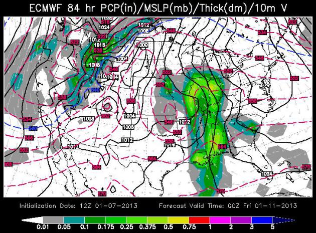
Warm Enough For...Rain? The ECMWF model, valid
Thursday evening, shows the main surge of rain pushing across the
Midwest toward St. Louis and Chicago, a little very light rain or
drizzle may brush parts of Minnesota, but the European model is whisking
most of the moisture to our south and east. Again. If it does
precipitate - it should be warm enough for light rain.
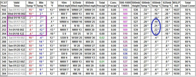
Dueling Model (Runs). I'm going to shows you 2 runs
of the same weather model, initialized with slightly different (current)
data. The 12z run Monday shows a sharp, concentrated burst of numbing
air between next Wednesday and Friday, January 16-18, maybe 3 nights
below zero. The 12z morning run has been consistently warmer than the
evening 00z run:
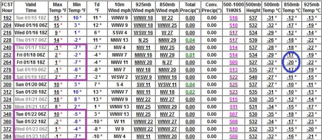
Two Waves Of Numbing Air? The 00z run of the GFS
isn't quite as cold, but it sustains the polar breeze longer with 2
distinct surges of bitter air, the first late next week, a second shot
of bitter air after Monday, January 21. So there's some debate as to how
long the chill will last, but little doubt it's going to be plenty cold
by the end of next week.
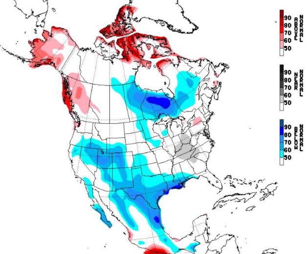
Temperature Trends. It appears that the Mother Lode
of bitter air may pass just to our north across Ontario, between January
15-21, according to NOAA NAEFS experimental temperature forecasts. Yes,
when Alaska is unusually warm we tend to be unreasonably cold.
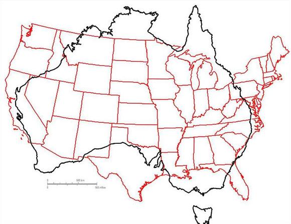
USA Snow Cover. At least report 66.6% of the lower
48 states - two thirds of America, reported snow on the ground. For a
NOAA loop showing how the snow cover has changed since October
click here.
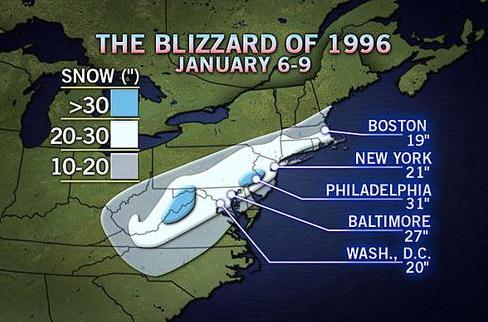
Remembering The Epic Blizzard of '96. AccuWeather takes a walk down memory lane - a storm that won't soon be forgotten in the northeast: "
A
powerful nor’easter unloaded 2 feet of snow and more from Virginia to
southeastern New England on Jan. 6-8, 1996. Up to 4 feet of snow was
unleashed. Philadelphia was at the heart of the storm, getting buried by
31 inches of snow. The Blizzard of ’96 still stands as the all-time
biggest snowstorm for Philadelphia. High winds howled across the
region, causing massive drifting and blowing of snow that significantly
reduced the visibility...."
* The Capital Weather Gang takes a nostalgic look back at the Infamous Blizzard of '96
here.
936 Tornadoes Nationwide In 2012. That's a low
number (25th greatest number since 1959) and that is due largely to
record heat and drought gripping much of American for much of late
spring and summer - reducing wind shear, pushing the zone of favorable
tornado conditions way north, into Canada. Here are a few statistics
from Greg Carbin at
NOAA SPC:
First Tornado.....................................8:45 AM CST, 9-Jan (EF0-TX)
Last Tornado......................................5:00 PM EST, 26-Dec (EF1-NC)
2012 Total Tornadoes..............................936 (Ranked 25th since 1950)
Record Annual Total..............................1817 in 2004
Greatest 2012 Monthly Total........................206 in April
Greatest Monthly Total on Record...................759 in April 2011
2012 Tornado Days..................................170
Annual Average.....................................178 (50-years, 1962-2011)
Record Tornado Days in Any Year....................211 in 2000
Why So Few Tornadoes Last Year? I created a 2:30
YouTube clip
explaining why the tornado count was so low in 2012 - just about the
only silver lining to a year of record heat and debilitating drought.
Video courtesy of WeatherNation TV.
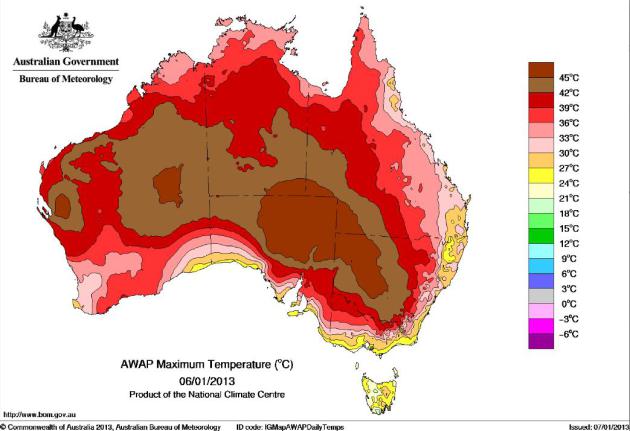
Record Heat Wave Grips Australia. Intense, historic
heat is gripping Australia, sparking water shortages and raging
wildfires. From climate scientist (and Australian resident) Stephan
Lewandowsky: "
Never before in recorded history has Australia
experienced 5 consecutive days of national-average maximum temperatures
above 39C. Until today. And this heat is expected to continue for another 24-48 hours, extending
the new record run to 6 or even 7 days. For context, the previous
record of 4 days occurred once only (1973) and 3 days has occurred only
twice (1972,2002)."
Map above courtesy of the Australian Bureau of Meteorology. The latest observations for southern Australia are
here. Most thermometers in Australia don't go above 50 C.
Perspective. Australia is nearly as large as the
lower 48 states of the USA - what is unusual is the extent (and
intensity) of 100 degree plus heat Down Under. More on the unprecedented
heat at
scienceblogs.com.
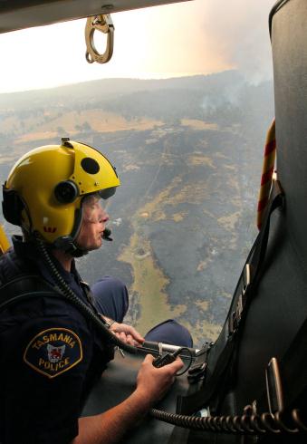
Tasmania's Fires Prompt PM's Grim Climate Warning. Here's an excerpt from Australia's
The Age: "
Prime
Minister Julia Gillard underscored the dangers facing Australia this
summer from climate change as she saw Tasmanian bushfire ruins, and
warned people to expect more. Ms Gillard said New South Wales faced
potentially catastrophic conditions on Tuesday, and the crisis was not
over in Tasmania. While the south-east fires that devastated Dunalley
were easing, the island faced a new emergency warning in north-west
dairy country near Mawbanna, where a fast-running fire threatened the
community..."
Photo credit above: "
Westpac Police rescue helicopter
crewman Sgt. Matthew Drumm surveys the fire near Dunalley, east of the
Tasmanian capital of Hobart, Australia, on Saturday, Jan. 5, 2013.
Australian officials battled a series of wildfires amid scorching
temperatures across the country on Saturday, with one blaze destroying
dozens of homes in the island state of Tasmania." (AP Photo/Chris Kidd, Pool)
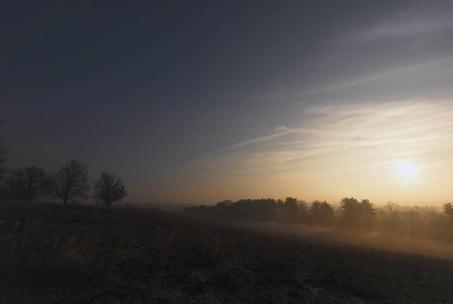
A Reluctant Sun.
Yes, the sun is still low in the sky, but we've picked up nearly 13
minutes of daylight since December 21. This photo was taken near King of
Prussia, Pennsylvania at the Valley Forge National Historical Park.
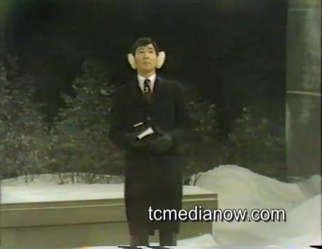
Nice Ear Muffs. What was I thinking? Here's a clip
from January 24, 1985, when a major blizzard was pushing across
Minnesota - courtesy of Tom Oszman and his remarkable library of local
TV clips going back decades, which you can access (for free) at
tcmedianow.com.
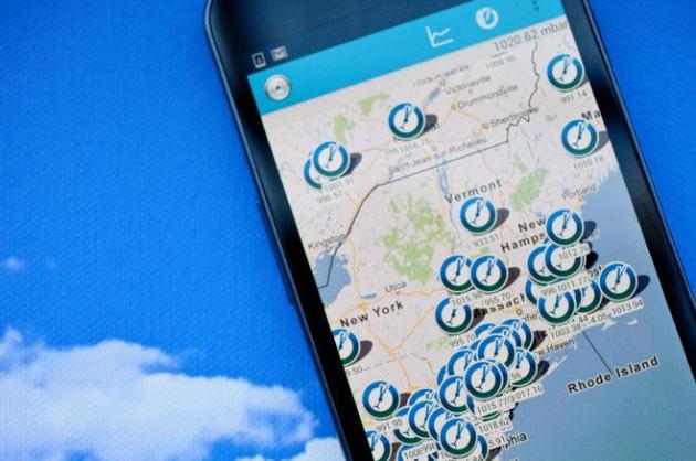
Your Android Phone Could Help Scientists Predict Your Weather.
Although measuring air temperature could be problematic (with that
fancy Samsung Galaxy III in your pocket most of the day) extracting air
pressure information seems to make more sense - can it really help
better initialize weather models?
Wired.com takes a look; here's an excerpt: "
The
Android phone in your pocket could help scientists do a better job of
predicting the weather — exactly where you are. Atmospheric scientists
are working with an app developer
to take air pressure information that is already being collected from
thousands of Android phones and feed it into sophisticated new climate
models. If they get enough buy-in from Android owners, you may be able
to receive warning hours in advance about thunderstorms and tornadoes
coming to your precise location with far more certainty than you can
today..."
The 13 Safest Cars For 2013.
Gizmag.com has the story; here's an excerpt: "
The
Insurance Institute for Highway Safety (IIHS) has released its list of
safest vehicles for the 2013 model year. In all, the list includes 117
cars that were awarded a Top Safety Pick. Thirteen cars were given the
Top Safety Pick+ award, which is an even higher award for vehicle
safety. These vehicles go deeper to bring a safer ride to drivers and
passengers, and we're going to take a quick look at each one..."
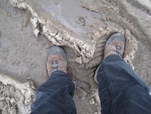
Aaaaah. Few other places on Earth would greet 30s
with relief. But in Minnesota, in early January, we call 36 F. a "warm
front". Admit it, it really did feel good out there yesterday; afternoon
highs in the 30s statewide. Old Man Winter will take the rest of the
week off, but return with a vengeance on Saturday.
Paul's Conservation Minnesota Outlook for the Twin Cities and all of Minnesota
TODAY: Mostly cloudy, above average temperatures. Winds: S 10. High: 33
TUESDAY NIGHT: Partly cloudy and cool. Low: 23
WEDNESDAY: Partly sunny, still milder than average for mid-January. High: 33
THURSDAY: Almost March-like. Rain or drizzle possible later in the day. Low: 25. High: 35
FRIDAY: Last mild day. Mostly cloudy. Low: 28. High: 36
SATURDAY: Burst of light snow. Windy & colder. Low: 15. HIgh: 19
SUNDAY: Partly sunny, feels like -10 F. Low: 8. High: 13
MONDAY: Lot's of sun - brisk. Low: 5. High: near 20
* image above courtesy of
The Burlington Free Press in Burlington, Vermont.
Climate Stories...
"....
And I can say right now, this very day we can look out the
window and there's CO2, carbon dioxide, pouring out of tailpipes,
pouring out of buildings, pouring out of smokestacks. And yet we can't
see it, it's invisible. The fundamental causes of this global problem
are invisible to us. And likewise the impacts are largely invisible to
us as well unless you know where to look. So it's a problem that
first of all we can't see. And secondly it's a problem that is
seemingly faceless. It's not like terrorists who we can imagine who
are coming after us trying to kill us and challenge our fundamental
values. It’s a problem that we can’t see, that’s going to have long
term impacts that aren’t going to just impact us now, but impact us
into the future; impact our children and our grandchildren"... - Anthony Leiserowitz, in an interview with
Bill Moyers.
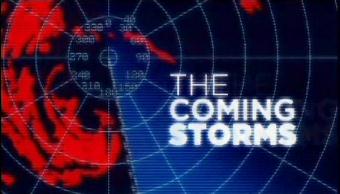
CNN's Hour-Long Climate Change Special Ignores Emissions. I watched the Sunday evening special on storm intensity and frequency, and I thought (overall) it was very well done.
Media Matters has a bone to pick - no direct attribution to man-made burning of fossil fuels - here's an excerpt of their critique: "
A
CNN special on the threat of more frequent extreme weather events
fueled by climate change ignored the role of manmade greenhouse gas
emissions in warming the atmosphere. The hour-long program, titled "The
Coming Storms," set out to examine
"the factors that made the impact of superstorm Sandy so devastating,"
featuring "insights from researchers and scientists on climate
change[.]" CNN did explore how climate change will amplify the impacts
of disastrous weather events like Hurricane Sandy. Given the network's track record of paying scant attention
to climate change even while reporting on its consequences, it was a
commendable effort. But CNN failed to make the distinction that climate
change is not a natural phenomenon; rather, it is driven by human
activity..."
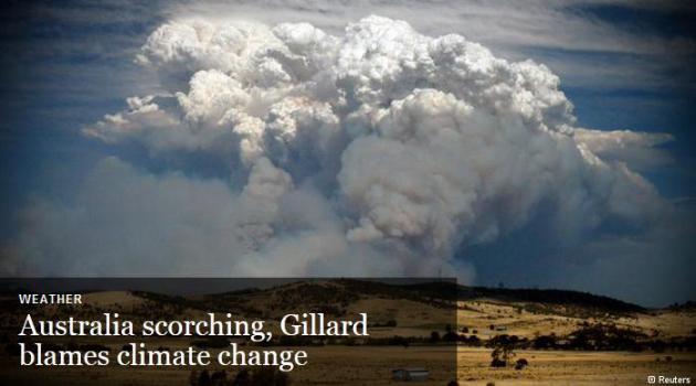
Australia Scorching, Gillard Blames Climate Change. Here's a snippet from
Deutsche Welle: "
Australian
has been bracing for near-record temperatures, with bushfires ablaze
in five out of six states. Police in Tasmania are still searching for
those reported missing after fire swept across the island last week.
Prime Minister Julia Gillard warned Australians of high bushfire risks
in coming days, highlighting global climate warming as the probable
cause. "We do know over time that as a result of climate change we are
going to see more extreme weather events and conditions." She urged
residents in vulnerable bush areas to decide in advance whether to
attempt to save their homes, if fire strikes, or opt to evacuate..." (photo courtesy of Reuters).
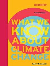
An Antidote For Climate Contrarianism. Here's a snippet from a
New York Times story: "...
Conservatives
will find a few points in the book that especially resonate. For
instance, while Dr. Emanuel assails the irrationality of dismissing an
entire branch of science as some kind of elaborate hoax — many
Republicans have done lately — as he also takes green groups to task on
certain points, including their skepticism about nuclear power. He sees
nuclear energy
as one of the few ways to reduce carbon dioxide emissions, which
contribute to global warming, on a large scale. And he is doubtful that
renewable energy sources like wind and solar power
can be ramped up fast enough to meet the challenge. If Dr. Emanuel has
been talking about his politics more lately, so have some of his
colleagues, like Richard Alley of Penn State, one of the country’s most notable explainers of climate science, who describes himself as a churchgoing Republican..."


No comments:
Post a Comment